Excellent!! I've been scouring the web for something like that!The Other Tom wrote:Maybe this will help.....
http://yosemitenews.info/forum/read.php ... #msg-52134" onclick="window.open(this.href);return false;
I think Parson's peak is on the right side of Parson's plateau in the picture.
Is this Vogelsang Peak?
-
Hikin Mike

- Founding Member
- Posts: 552
- Joined: Fri Oct 28, 2005 5:56 pm
- Experience: N/A
- Location: Atwater, CA
- Contact:
Re: Is this Vogelsang Peak?
-
maverick

- Forums Moderator

- Posts: 11853
- Joined: Thu Apr 06, 2006 5:54 pm
- Experience: Level 4 Explorer
Re: Is this Vogelsang Peak?
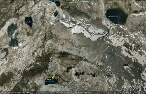
The peak in the middle in the last photo is Parson's Peak. In this snapshot from
Google Earth PP is located south of Ireland Lake and is marked by the green triangle
to the right of where the straight green line meets the Sierra Crest (marked by the
green curvy line).
VP is located by the green triangle at the far left edge of the snapshot in the middle.
Google Earth PP is located south of Ireland Lake and is marked by the green triangle
to the right of where the straight green line meets the Sierra Crest (marked by the
green curvy line).
VP is located by the green triangle at the far left edge of the snapshot in the middle.
Professional Sierra Landscape Photographer
I don't give out specific route information, my belief is that it takes away from the whole adventure spirit of a trip, if you need every inch planned out, you'll have to get that from someone else.
Have a safer backcountry experience by using the HST ReConn Form 2.0, named after Larry Conn, a HST member: http://reconn.org
Who is online
Users browsing this forum: No registered users and 9 guests