Photos or it didn't happen!oldranger wrote:The stretch of 5 days was broken by a strikingly beautiful naked lady!)
Mike
Kerrick / Matterhorn Canyon Loop (Cross Country Routes)
-
TehipiteTom

- Founding Member
- Posts: 953
- Joined: Thu Aug 24, 2006 8:42 am
- Experience: Level 4 Explorer
Re: Kerrick / Matterhorn Canyon Loop (Cross Country Routes)
-
mshields
- Topix Acquainted
- Posts: 61
- Joined: Fri Nov 19, 2010 8:40 pm
- Experience: N/A
- Location: Ojai, Ca
Re: Kerrick / Matterhorn Canyon Loop (Cross Country Routes)
Could I get the GPS coordinates to that spot! 
-
oldranger

- Topix Addict
- Posts: 2861
- Joined: Fri Jan 19, 2007 9:18 pm
- Experience: N/A
- Location: Bend, Oregon
Re: Kerrick / Matterhorn Canyon Loop (Cross Country Routes)
TT
Whatever!
mshields
I think she probably moved on and she is probably well into her 50s (which at my age is prime).
Mike
ask no more questions for a week as I enter the Eaglecap Wilderness tomorrow AM!
Mike
Whatever!
mshields
I think she probably moved on and she is probably well into her 50s (which at my age is prime).
Mike
ask no more questions for a week as I enter the Eaglecap Wilderness tomorrow AM!
Mike
Mike
Who can't do everything he used to and what he can do takes a hell of a lot longer!
Who can't do everything he used to and what he can do takes a hell of a lot longer!
-
mshields
- Topix Acquainted
- Posts: 61
- Joined: Fri Nov 19, 2010 8:40 pm
- Experience: N/A
- Location: Ojai, Ca
Re: Kerrick / Matterhorn Canyon Loop (Cross Country Routes)
You got it; I suppose I got my moneys worth out of you for a week.oldranger wrote:
ask no more questions for a week as I enter the Eaglecap Wilderness tomorrow AM!
Mike
On a side note I came across another very good trail report for this area. (Thank you LVRAY)
http://yosemitenews.info/forum/read.php?3,58544" onclick="window.open(this.href);return false;
-
phenocryst
- Topix Acquainted
- Posts: 20
- Joined: Mon Jul 16, 2012 11:11 am
- Experience: N/A
Re: Kerrick / Matterhorn Canyon Loop (Cross Country Routes)
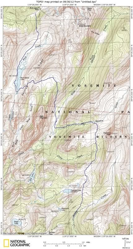
I have gone from Rock Island Lake to Slide canyon (10 yrs ago?) and from Slide to Rock Isl (last month). The route is straightforward in both directions but for me it was easier to find the best way going down (east). There was a little more decision-making involved going uphill... going down, the terrain just leads you.
I wondered if I would have trouble finding the ramp from the bottom but it is very obvious.
We approached via Wilson Creek and Tallulah and Doe. Again, routefinding is straightforward and hiking generally very easy. From the outlet of Doe Lake we headed northeast down an easy slope to Camp creek and down into Slide at the lower end of the meadows near the outlet of Big Meadow creek. The slope directly north of the outlet looked a lot less friendly.
I would strongly second the recommend to go via Rock Isl Lk rather than up Slide cyn... but The Slide is quite a sight and, if you have the time, worth a side trip to see.
-
mshields
- Topix Acquainted
- Posts: 61
- Joined: Fri Nov 19, 2010 8:40 pm
- Experience: N/A
- Location: Ojai, Ca
Re: Kerrick / Matterhorn Canyon Loop (Cross Country Routes)
Thanks for the input phenocryst.phenocryst wrote:I have gone from Rock Island Lake to Slide canyon ........The route is straightforward in both directions but for me it was easier to find the best way going down (east).
We approached via Wilson Creek.....
From the outlet of Doe Lake we headed northeast down an easy slope to Camp creek and down into Slide at the lower end of the meadows near the outlet of Big Meadow creek.
- I am thinking of coming down from RIL and camping at the open area near Big Meadow Creek; at this location I can do a day hike to the slide. (best of both worlds)
- How far up did you proceed on Wilson Creek before heading west?
- I am assuming you stayed on the west side of Camp Creek on your way down from Doe?
Last edited by mshields on Fri Sep 28, 2012 11:00 pm, edited 1 time in total.
-
mshields
- Topix Acquainted
- Posts: 61
- Joined: Fri Nov 19, 2010 8:40 pm
- Experience: N/A
- Location: Ojai, Ca
Re: Kerrick / Matterhorn Canyon Loop (Cross Country Routes)
Oldranger,oldranger wrote: ask no more questions for a week as I enter the Eaglecap Wilderness tomorrow AM!
Mike
I noticed you are back; I will have to come up with some questions
P.S. - Got "Splendid Mountains" in the mail today; am going to read the McClure section tonight.
mshields
-
Wandering Daisy
- Topix Docent
- Posts: 6753
- Joined: Sun Jan 24, 2010 8:19 pm
- Experience: N/A
- Location: Fair Oaks CA (Sacramento area)
- Contact:
Re: Kerrick / Matterhorn Canyon Loop (Cross Country Routes)
This is part of the trip I did in 2008, early season. Not saying it is the best route, but it worked. Just a warning- Slide Canyon meadow near Bath Mountain is FULL of mosquitoes. It was so bad that I could not even camp down there. However, Rock Island Lake was really pretty - still partly frozen and snow surrounding it. Dropping down the salbs to the meadow below Bath Mountain was quite steep. I had no previous information so I just winged it. I intersected the PCT near Benson Pass, then went back on the tril via Matterhorn Canyon, Burro Pass, Mule Pass, Robinson Lk.
-
mshields
- Topix Acquainted
- Posts: 61
- Joined: Fri Nov 19, 2010 8:40 pm
- Experience: N/A
- Location: Ojai, Ca
Re: Kerrick / Matterhorn Canyon Loop (Cross Country Routes)
Thanks for that bit of info; I have heard a few others also mention this general area as being problematic. Perhaps a late season trip would help increase my odds?Wandering Daisy wrote: Just a warning- Slide Canyon meadow near Bath Mountain is FULL of mosquitoes. It was so bad that I could not even camp down there.
I appreciate the topo. I noticed you went down Wilson Creek; do you recall how the navigation was through there?
Here is an interesting piece of history; that steep section you mentioned dropping down to the Slide Canyon meadows (below Bath Mountain) was navigated in 1895 by McClure on horseback. A couple HST members (TehipiteTom and OldRanger) gave me this piece of info. I just recently read McClures account in the "Splendid Mountains" book. Pretty cool stuff!
Thanks again
-
oldranger
- Topix Addict
- Posts: 2861
- Joined: Fri Jan 19, 2007 9:18 pm
- Experience: N/A
- Location: Bend, Oregon
Re: Kerrick / Matterhorn Canyon Loop (Cross Country Routes)
I know I've mentioned this before but my strategy for N. Yosemite is to limit my trips to Sept. of Wet years. Water available and no mosquitoes. We all know that mosquitoes early in the season doesn't necessarily translate to mosquitoes later in the season. Last year was an exception--plenty of water in september but also mosquitoes.
Mike
Mike
Mike
Who can't do everything he used to and what he can do takes a hell of a lot longer!
Who can't do everything he used to and what he can do takes a hell of a lot longer!
Who is online
Users browsing this forum: No registered users and 16 guests