I was just going to enquire whether anyone had visited Gorge of Despair and I saw this TR. Great photos of the valley segment! Has anyone visited the upper part of "The Gorge"?
cg
Upper Gorge of Despair
-
cgundersen

- Topix Fanatic
- Posts: 1338
- Joined: Sun Jul 16, 2006 1:07 pm
- Experience: N/A
-
vandman

- Topix Regular
- Posts: 283
- Joined: Wed Jul 15, 2009 1:08 pm
- Experience: Level 4 Explorer
- Location: Charlotte, NC
Re: tehipite to tunemah to ionian - trip report
These guys have been to the top of the gorge...http://www.summitpost.org/gorge-of-despair/152446" onclick="window.open(this.href);return false;
http://wildernessjournals.tumblr.com" onclick="window.open(this.href);return false;
http://vanmiller.tumblr.com" onclick="window.open(this.href);return false;
http://vanmiller.tumblr.com" onclick="window.open(this.href);return false;
-
TehipiteTom
- Founding Member
- Posts: 953
- Joined: Thu Aug 24, 2006 8:42 am
- Experience: Level 4 Explorer
Re: tehipite to tunemah to ionian - trip report
Here's the upper end of the Gorge of Despair from Harrington Pass:
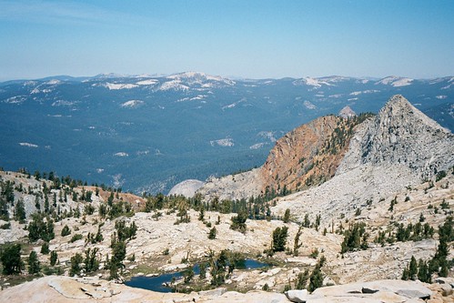
Looks like you could descend a ways without any technical climbing; looks pretty spectacular if you do.
Looks like you could descend a ways without any technical climbing; looks pretty spectacular if you do.
-
hal
- Topix Novice
- Posts: 7
- Joined: Fri Jul 01, 2011 2:37 pm
- Experience: N/A
Re: tehipite to tunemah to ionian - trip report
Sigh .... my last solo backpacking trip was to the Gorge of Despair, after a scramble over Harrington Pass, many years ago. It was one of my most memorable trips, and it was not technical descending in the gorge. I had the place to myself for a couple of days, and bagged one of western peaks, but I can't remember the name. It had a register on top, though. Also, I saw some piles of small quartz pebbles that looked like they were man-made, so I've always wondered if folks were checking out the place for gold. I think I followed the route as outlined by Secor.
Brian R
Brian R
-
TehipiteTom
- Founding Member
- Posts: 953
- Joined: Thu Aug 24, 2006 8:42 am
- Experience: Level 4 Explorer
Re: tehipite to tunemah to ionian - trip report
Sounds like a great trip. Any photos?hal wrote:Sigh .... my last solo backpacking trip was to the Gorge of Despair, after a scramble over Harrington Pass, many years ago. It was one of my most memorable trips, and it was not technical descending in the gorge. I had the place to myself for a couple of days, and bagged one of western peaks, but I can't remember the name. It had a register on top, though. Also, I saw some piles of small quartz pebbles that looked like they were man-made, so I've always wondered if folks were checking out the place for gold. I think I followed the route as outlined by Secor.
Brian R
-
hal
- Topix Novice
- Posts: 7
- Joined: Fri Jul 01, 2011 2:37 pm
- Experience: N/A
Re: tehipite to tunemah to ionian - trip report
I made the trek about 15 years ago, before digital cameras were the norm. I have transparencies, but no scanner. But photography was always a first and foremost activity in the morning and evenings, when shadows created depth. Back in the day when I lugged a Nikon F, Sekonic Spotmeter, 28mm, and 105mm lenses along for the ride. There was nothing ultralight about my solo trips.
Brian R
Brian R
-
cgundersen
- Topix Fanatic
- Posts: 1338
- Joined: Sun Jul 16, 2006 1:07 pm
- Experience: N/A
Re: tehipite to tunemah to ionian - trip report
Tehipite/Vandman,
Thanks guys; that looks like a great late season option. And, given the dearth of reports on that region, I'd guess it's peaceful even when other places are crawling. Well, another trip for the wisk list!
cg
Thanks guys; that looks like a great late season option. And, given the dearth of reports on that region, I'd guess it's peaceful even when other places are crawling. Well, another trip for the wisk list!
cg
-
maverick

- Forums Moderator

- Posts: 11853
- Joined: Thu Apr 06, 2006 5:54 pm
- Experience: Level 4 Explorer
Re: Upper Gorge of Despair
Hi CG,
Split this topic so not to piggyback of the OP thread.
That whole place is pretty and relatively easy crosscountry. Swamp and Slide Lakes
are just gorgeous. The upper Slide Lake is surprisingly emerald green which was a
treat. Followed Slide Creek down to the its junction with Kennedy Creek where things
started to get pretty steep. Would love to revisit the area and see the lowest and western
most lakes of the Swamp Lake region.
Professional Sierra Landscape Photographer
I don't give out specific route information, my belief is that it takes away from the whole adventure spirit of a trip, if you need every inch planned out, you'll have to get that from someone else.
Have a safer backcountry experience by using the HST ReConn Form 2.0, named after Larry Conn, a HST member: http://reconn.org
-
cgundersen
- Topix Fanatic
- Posts: 1338
- Joined: Sun Jul 16, 2006 1:07 pm
- Experience: N/A
Re: Upper Gorge of Despair
Hi Mav,
Imagine my surprise when I saw this thread, but it all makes sense. It'll be a year or two before this area rises to the top of the heap, but I'm certainly looking forward to a part of the Sierra I've seldom visited. Great photo from the Harrington ridge!
Thanks,
cg
Imagine my surprise when I saw this thread, but it all makes sense. It'll be a year or two before this area rises to the top of the heap, but I'm certainly looking forward to a part of the Sierra I've seldom visited. Great photo from the Harrington ridge!
Thanks,
cg
-
maverick
- Forums Moderator
- Posts: 11853
- Joined: Thu Apr 06, 2006 5:54 pm
- Experience: Level 4 Explorer
Re: Upper Gorge of Despair
Make sure you include the Volcanic Lakes area too.
Professional Sierra Landscape Photographer
I don't give out specific route information, my belief is that it takes away from the whole adventure spirit of a trip, if you need every inch planned out, you'll have to get that from someone else.
Have a safer backcountry experience by using the HST ReConn Form 2.0, named after Larry Conn, a HST member: http://reconn.org
I don't give out specific route information, my belief is that it takes away from the whole adventure spirit of a trip, if you need every inch planned out, you'll have to get that from someone else.
Have a safer backcountry experience by using the HST ReConn Form 2.0, named after Larry Conn, a HST member: http://reconn.org
Who is online
Users browsing this forum: Google [Bot], Google Adsense [Bot], jefffish, RiseToADry and 35 guests