
Trip photos: https://flic.kr/s/aHBqjAUhH6
After about a year of planning, my wife Adrienne and I finally embarked on our grand Sierran voyage in mid August, to celebrate my 40th birthday. We first drove down to Chiloquin, OR to drop off our dog at my mom’s riverside dog resort. Ma grilled a delicious tri-tip and we sat out on her deck to watch the Perseids. The following day we continued on to Reno where we visited family and their tiny dogs while we waited for my sisters to arrive by air in the wee hours of the morning.
8/15
As my sisters prepped for the hike, I picked up the first of several incredible burritos we’d enjoy on our trip (shoutout to Chavo’s Mexican Grill aka Tortas Ebenezer). So fueled, the four of us hit the road on Highway 395. Having always lived and worked on the west slope of the Sierras, I’d actually never driven the stretch of 395 from Reno to Bishop—it lived up to its storied reputation. It afforded incredible views of the incredible amount of snow still remaining in the backcountry, not to mention the rain clouds towering above. We began discussing packing revisions (rain pants, etc.) and I began to regret not packing microspikes or encouraging others to bring any kind of traction devices. August snow had never been an issue in any of my three seasons in the Sierras.
The goal of our trip was to thru-hike from Piute Pass to Mono Pass, which would require stashing cars at the exit point, the Mosquito Flats trailhead. We met the rest of our enormous gang (13 people!) there and spent some time milling excitedly around in the parking lot and exchanging hugs. Jared and Lindsy gave me the high honor of a brand new Melanzana fleece (available by appointment only in Leadville, CO!). The folks leaving their cars behind took a little time to finalize their packing and then we squeezed into the remaining vehicles for the drive to our group camp at Bishop Park. We also gave a couple of Texans a ride down valley. An omen: they had been rained out of the high country.
We swung through Bishop to grab pizzas and do a bit of last minute shopping. I stood in a parking lot while the dramatic light on the peaks filled me with a mixed sense of wonder (that this setting used to be commonplace to me) and belonging (part of me never left?).
At last we all reconvened at our group camp to chow down and do a little itinerary/Leave No Trace/bear safety briefing. Michael (trail name = “Brown Cloud”) and Sara gifted me some whiskey (9-year-old knob) and brought out custom snot rags (emblazoned with a deep fake photo of me picking my nose) for the whole crew. Betty (trail name = “Mono Diggins”) also unveiled the decadent brownies she’d brought all the way from New Orleans. As a wall of people sheltered a candle from the wind, I got a rousing rendition of “Happy Birthday” and Erin learned for the first time that the trip was in any way birthday-related!
I tried to sleep out ‘neath the stars, but a few rain drops chased me into the tent. I did not sleep much in either location—I was too excited for the start of our adventure.
8/16
Piute Pass Trailhead to Desolation Lake — ~11.9 miles and 3300 feet (w/ the scouting mission to Puppet Pass)

We started each morning of the trip by gathering for a reading. Since we’d be hiking between Mount Emerson and Mount Thoreau on Day 1, I thought it appropriate to start that day with a passage that Thoreau wrote, describing a mountain he climbed in a dream:
- “I steadily ascended along a rocky ridge half clad with stinted trees, where wild beasts haunted, till I lost myself quite in the upper air and clouds, seeming to pass an imaginary line which separates a hill, mere earth heaped up, from a mountain, into a subterranean grandeur and sublimity. What distinguishes that summit above the earthy line, its that it is unhandselled, awful, grand. It can never become familiar; you are lost the moment you set foot there. You know no path, but wander, thrilled, over the bare and pathless rock, as if it were solidified air and cloud….It is as if you trod with awe the face of a god turned up, unwittingingly but helplessly, yielding to the laws of gravity.”
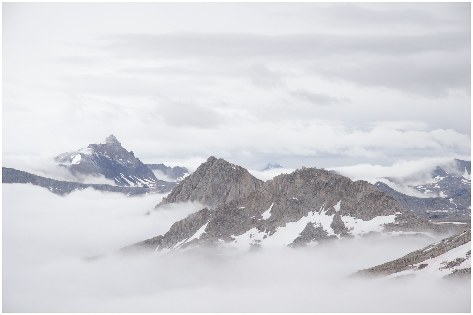
The Piute Pass trail starts out pretty high (9360 ft) and takes a stock-graded angle past Loch Leven and Piute Lake, up into what Kim Stanley Robinson calls “the God Zone” (above treeline), and then eases over the pass at 11420 feet. After spreading out along the trail, we reconvened at the pass and watched the clouds steadily build. We had a brief shower and heard some distant thunder on our way down from the pass, but it was sunny and splendid by the time we had to decide whether to descend to more lightning friendly/sheltered terrain or to continue on towards our target campsite at Desolation Lake, amid the high, flat, and very exposed expanse of Humphreys Basin. The clouds appeared to be skimming by us to the south and west, but we were quickly reminded of how fickle such weather can be in the mountains. We had just set up camp to the west of Desolation Lake when a heavy rain set in. Most folks chose to get in their tents and wait it out, but Adrie and I made the mistake of choosing to cook dinner first—we thought the rain might be long-lasting. Adrienne was quickly soaked through, so I encouraged her to get in the tent and warm up while I finished dinner.
I still needed to scout out Puppet Pass, which was kind of the “crux” of our trip. As planned, it was the only part of our itinerary that was supposed to be class 2. I wanted to make sure that our big, mixed-experience party could traverse it safely. I hoofed it up to the pass and was rewarded with a scene so beautiful it brought a tear to my eye. Post/mid-storm clouds swirled across a dusky scene. Directly below was Puppet Lake and a number of other perfectly perched lakes. In the distance rose Seven Gables, which I’d climbed 15 years earlier with Sami. Nearly the entirety of the day 2 route was laid out below and it all seemed so very attainable. I wanted to stay there until the spell broke, but I had a bit over a mile of off-trail travel to get back to camp. Turning around, I saw a beam of low-angle sunlight striking the ribbed flank of Mt Humphreys, presiding over the basin. I scouted a better way to the pass (via Mesa Lake) on my way back and also found some primo campsites near that lake, to file away for another time. I got back to Desolation just as it was getting dark and folks were starting to wonder if my bleached bones would be found the next summer. Spirits were still high among the crew and only got higher following my report that Puppet Pass looked doable. We added to our the positive vibes with spirits of a different nature and then retired to our tents.
Soon thereafter, the weather returned with a vengeance, including a fierce period of hail and some lightning within a few miles of us. The night was fairly sleepless for Adrie and me, but our tent held strong amid the onslaught.
8/17
Desolation Lake to Royce Lake #2 via Puppet Pass and direct approach from Pine Creek Pass (6.9 miles, 1900 feet)

A definition of breathing by Kevin Adonis Browne from Ordinary Notes by Christina Sharpe (Adrienne’s selection):
- “Breathing is the beginning. It is, for us, a first and final moment. In it, we find the prototype of all method, without which: nothing. Breathing, thus, is the foregrounding of all concept—its precursor and first condition, its resolution. Before and after language, and if all that comes and goes unuttered, it is that block of text in the negative space of the page, noticed from the corner of the eye. A premium in these times. Dear. Dearer still. It is how, through the movement of space, life is able to consider itself—and we, by holding it, are able to grasp a finitude that cannot otherwise be grasped, a meaning that cannot be held. Breathing is life delivered as soliloquy, but which echoes the vast chorus. A quiet—often rushed, sometimes heavy, sometimes as labored as the horizon, sometimes as rattled as stone in a half-emptied chest. But there, in the persistent “come hither” and “go forth” of its unseen stillness, is the microscopy of intention that—after bursting into ether and settling to engulf the heart—begins again."
After Adrienne (trail name = “Dream Weiner”) read her selected poem, the crew dropped down to Mesa Lake and then up a small side drainage to Puppet Pass. I found a fully rigged fishing pole stashed behind a boulder at Mesa Lake, only slightly rodent-gnawed.
After reaching Puppet Pass we paused to soak in the sights, snap a group photo, and strategize our descent (we found out later that Sara also took this moment to break a crown on a turgid electrolyte gummy proffered by Judas, er, Jared). We divided into 3 “pods” with 1 or 2 experienced folks in each, to minimize rockfall danger, then set out in a staggered start. We tried to avoid the areas with the largest, most unwieldy talus and bore steadily right towards a granite escarpment along which a use-trail descended towards Puppet Lake. With no cloud build-up (i.e., no thunderstorm danger), we had a casual lunch on the shores of the lake and dried our tents in the meadow. Lindsy passed out stickers she had made specially for the trip. They depicted a dramatic Sierran peak with rocks and a lake in the foreground (my name was hidden in cursive in the rocks). We were supposed to figure out which mountain it was! What a thoughtful gesture.
My dad (aka Da) revealed that he had brought along a soccer jersey from an Argentinian club team. He’d apparently given a Grand Canyon tour to the owner and promised to take some pictures while garbed in the kit. I asked if he wanted to take a photo there at Puppet Lake and he declined at first, saying it wasn’t “epic enough”. I stared dumbfounded at the vista of peaks and infinity-pool-esque lakes until he relented.
After lunch, we headed east around a narrow granite shoulder (encountering the first of many mountain lion tracks on our voyage) and skimmed by Star Lake before dropping down to intersect a social trail between Moon and Little Lakes. Erin and I discussed contouring over to French Lake to get to Pine Creek Pass, but decided that some trail-cruising might be nice after the off-trail start to the morning. We dropped through lovely Whitebark Pine woodland and past a solo hiker camped near Elba Lake. A brief encounter transformed into an inquisition as he intercepted us, transforming into the bridge keeper from Monty Python and the Holy Grail. He proceeded to grill us while we were devoured by mosquitoes. We finally extricated ourselves from his quizzing, but quickly paused again to marvel at Royce Falls on the opposite side of the valley. This is thought to be the highest-elevation large waterfall in the Sierras, starting at about 11,000 feet and dropping 700 ft. to the glacial “U” of French Canyon.
Inspired by the waterfall, we also dropped a few hundred feet into French Canyon, then continued up to the broad, flat approach to Pine Creek Pass. Shortly after returning to the “god zone”, we cut cross-country to the northwest, shooting for Royce Lakes. Each off us set our own pace and angle of attack up the slope, picking our way amid dry alpine fell-fields and tundra. The wildflowers continued to amaze. We crested the gentle slope south of Treasure Benchmark and picked out some lovely campsites amid the rocks on the east shore of Royce Lake #2. There were still ice bergs floating in the lake—the other paternoster lakes up the drainage were covered by progressively more ice. Here we confirmed that the peak on Lindsy’s stickers was Merriam Peak! Despite our best efforts at telekinesis, our combined mind powers were not sufficient to dislodge the absurd rock teetering on the nose of Merriam.
If I thought morale was high between rain showers and lightning strikes the night before, people were positively giddy in camp on night #2. Whiskey and rotgut, er, everclear were shared during and after dinner and a game of Jeopardy was completed between those “on the rock” and “off the rock”. As dusk fell, we walked down-valley slightly to watch the clouds and take a few hundred photos of the light changing on Merriam. Graydon (aka GRDI) nonchalantly asked if people wanted to “headlamp up to the ridge and look at the stars”. All those remaining outside of their tents instantly said yes and headed off. We swore at Musk’s Starlink launches and “ooo’d” at the Perseids (except for Michael, who somehow missed every one). Thus ended our one day without precipitation.
8/18
Royce Lake 2 to Lake Italy via Royce Pass and Italy Pass (6.1 miles, 1600 ft)

God's Grandeur By Gerard Manley Hopkins (Graydon’s selection)
- The world is charged with the grandeur of God.
It will flame out, like shining from shook foil;
It gathers to a greatness, like the ooze of oil
Crushed. Why do men then now not reck his rod?
Generations have trod, have trod, have trod;
And all is seared with trade; bleared, smeared with toil;
And wears man's smudge and shares man's smell: the soil
Is bare now, nor can foot feel, being shod.
And for all this, nature is never spent;
There lives the dearest freshness deep down things;
And though the last lights off the black West went
Oh, morning, at the brown brink eastward, springs —
Because the Holy Ghost over the bent
World broods with warm breast and with ah! bright wings.
We encountered a party of 8 (so tiny!) camped at Royce Pass, then continued just over the crest of the pass to take a brief break and take in the views. With a direct vantage down Pine Creek, we could see Owens Valley 6000 feet below and then 14200 ft. White Mountain Peak on the opposite side of the basin. In the foreground, we got our first look at the intrusion-striped bulk of Peppermint Peak.
We descended the other side via lovely class 1 granite-rambling and snow fields. Shortly after trumpeting the joys of Sierran granite, I promptly slipped on a water-slicked portion and knocked the wind out of myself. Rather than descend all the way to Honeymoon Lake to pick up the Italy Pass trail, we aimed for a tarn in a grove of Whitebarks at about 11,120 ft, then contoured around. After pole-vaulting the creek, we were back on trail. Though unmaintained, the trail up to Italy Pass was easy to follow whenever it mattered and then became more of a cairn-marked suggestion closer to the pass. Granite Park (a boring but appropriate name) was a wonderland of waterfalls, meandering streams, and meadows, all backdropped by Feather Peak, Bearpaw, and unnamed peaks that would be iconic tourist destinations in any other range. To the south, Mount Humphreys continued to glower over us.
We had “Pranzo” at Italy Pass, where Da pulled out a full tube of Pringles to share (still not sure how those fit in a bearcan!) and then posed for more photos in his soccer jersey. From the pass, we got a good look at Dancing Bear Pass, which still had snow on the northern approach. Not for the last time, I cursed myself for not bringing at least an ice axe to aid in exploration. We echo’d Kim Stanley Robinson in thinking that Toe Lake was a dumb name for a lake positioned at the kicking end of Lake Italy—clearly it should have been dubbed Lake Sicily. Not to mention, Lake Italy is backwards. We also decided to rename Mount Julius Caesar as Mount Pizza Pizza, since the cartoon pizza mascot is the only Caesar we thought worthy of such an honor.
Clouds were building rapidly as we descended past Jumble Lake, so we decided to establish camp on the south shore of Lake Italy rather than explore the route to the outlet as initially planned. On our first day, we had run into some fellows who had done this portion of our route in reverse. They had advised that there was steep snow between Jumble lake and the outlet and to “stay high” if we did not have traction devices, etc. We’d find out the nature of this hazard the following day.
In the meantime, we found some choice tent pads on a stubby peninsula near the inflow coming down from Jumble Lake. While the Roper guide (“The Sierra High Route”) describes Lake Italy as “not particularly interesting”, I was blown away by the dramatic views of Mount Abbott and Bear Creek Spire, all backdropped by ominously darkening clouds. The storm held off until everyone’s tents were assembled and this time Adrienne and I did not make the mistake of getting needlessly wet. After a brief downpour and lightning within less than a mile of us, the rain slacked off to a pleasant tip-tap on the rain fly and I enjoyed a glorious power nap.
The rain stopped and I poked my head out of the tent to find GRDI doing the same a short distance away. He hissed like a cornered feral cat and pretended to throw rocks at me to defend his territory.
Another dinner was prepared and I felt a deep comfort listening to people from different epochs of my life get to know one another (and then mercilessly crush each other at Jeopardy). GRDI also irrevocably established himself as the hero of the trail by recovering an IRREPLACEABLE bear-can-opening nickel that someone dropped in a crack between the rocks. He was the only one with the wingspan necessary to reach the critical currency.
The clouds departed before night fell. We were treated to another sea of stars, yet cursed by another string of Starlink launches. We lay on our silky smooth dinner rock and enjoyed the distantly burning gas balls and the utter quiet. Shortly after Michael went to bed, the remaining star-watchers saw what appeared to be a comet striking the earth and hastening a mass extinction event—or maybe it was just a very bright, long-lasting meteor that seemed to surge and change color as it approached the earth. I won’t soon forget that one.
8/19
Lake Italy re-route scouting (2.3 miles, 1000 ft)

John Muir on Mt Ritter, by Gary Snyder (Michael’s selection):
- After scanning its face again and again,
I began to scale it, picking my holds
With intense caution. About half-way
To the top, I was suddenly brought to
A dead stop, with arms outspread
Clinging close to the face of the rock
Unable to move hand or foot
Either up or down. My doom
Appeared fixed. I MUST fall.
There would be a moment of
Bewilderment, and then,
A lifeless rumble down the cliff
To the glacier below.
My mind seemed to fill with a
Stifling smoke. This terrible eclipse
Lasted only a moment, when life blazed
Forth again with preternatural clearness.
I seemed suddenly to become possessed
Of a new sense. My trembling muscles
Became firm again, every rift and flaw in
The rock was seen as through a microscope,
My limbs moved with a positiveness and precision
With which I seemed to have
Nothing at all to do.
This day was planned as a rest day / exploration day. The “explorers” planned to hike to Gabbot Pass, but first needed to scope out the snow that we’d been warned about on day 1. We could only see it imperfectly from camp. As we approached, we knew we had a challenge ahead of us. The angle was perhaps only a few degrees greater than the hard snow we’d crossed at Royce Lakes, but the runout was worse, terminating in a 10 ft drop into either the lake or onto broken ice—probably not fatal, but definitely not a good time. I thought we could do it late in the day, especially with the people with stiffer boots leading the way and kicking steps, but it would require a lot of commitment/confidence from the less experienced folks. In the end, Jeremy listened to his gut and wisely shared that he did not feel good about giving it a try, so we put our heads together and decided on the following course of action: A “high route” team (GRDI, Erin, and myself) would look for a route up and around the snow/ice that would get us back down to the outlet (or further down the Hilgard Branch of Bear Creek). Meanwhile, Michael, Jared, and Lindsy would explore the “long way ‘round” the lake to access the outlet via the north shore (this would require negotiating an infamously shitty section of unconsolidated talus between our campsite and the east tip of the lake). Finally, Jeremy would head to camp and let the “resters” know what was going on and that we might need to move camp that day after all. We would all reconvene in a couple of hours to decide on our course of action.
The “high” team hoofed it up to the ridgeline south of Lake Italy (east of point 11943) and quickly found two doable routes, one that descended fairly directly via a gully just south of the “nose” of the ridge, and another that headed more towards Teddy Bear Lake before intersecting with the trail. The route up to the ridge from Lake Italy was class 2 and was gonna take a while with our large group and varied experience levels, however. We headed to camp to share our findings. With clouds already building, we hoped that the “long way ‘round" explorers had found a route that might keep us less exposed to weather/lightning and be less stressful to the folks unaccustomed to scrambling.
Unfortunately, the “long way ‘round” group found loose, shifting boulder fields separated by steep snow gullies. That route was an immediate no-go. We estimated it would take 3-4 for hours for all of our group members to get up and over the route that the high team had scouted—the darkening skies did not seem like they would hold that long. If we waited until the following morning, we would have to do that fairly strenuous section in addition to what was already supposed to be a 15+ mile day. And if we shortened THAT day, it would turn the final day (also planned to be ~15 miles) into a true epic, after which some people would still need to drive all the way back to San Francisco or San Diego. A major revision to our itinerary was in order.
One idea was to backtrack over Italy Pass, then take Pine Creek Pass to French Canyon and essentially take the all-trail version of our inbound hike back to North Lake. However, the people who most needed to leave quickly after the hike had their cars stashed at Mosquito Flats, not at North Lake, so this would not do much to alleviate our time crunch. Da also remembered seeing a sign at the trailhead about a washout on the Pine Creek Pass trail, adding uncertainty about whether the route was even possible. We decided to go ahead and backtrack to Italy Pass and then down to Honeymoon Lake, but rather than head south over Pine Creek Pass, we would drop all the way down the valley to Pine Creek trailhead, then continue over Morgan Pass to Mosquito Flats. This would be 100% on trail, with manageable mileage, but with some big elevation gain. We also thought (I’m not sure why) that there was a campground at Pine Creek trailhead where some folks could crash if they didn’t want to do the final leg over Morgan Pass. I was a bit hesitant (though I didn’t voice this) to hike back through and then continue on from a trailhead, because from past experience I knew that there was a chance that a critical mass of the group would simply want to bail at that point of contact with civilization. All things considered, however, it seemed like our best option.
The rain showers rolled in and we all retreated to our tents for our afternoon naps…but then the rain didn’t stop. Eventually there was a break during which we were able to prepare dinner and agree on an early start time for the following morning (6:30 AM). It rained through the night (no lightning) other than another brief break which was apparently willed into existence by those who really needed to pee. We didn’t know that this was our first wave of weather from Tropical Storm Hilary.
8/20
Lake Italy to Pine Creek Trailhead (11 miles, 3300 feet of gain, 6000 feet of descent — includes climb of Mt Pizza Pizza).
The St. Crispin’s Day speech from From Henry V, Act IV, Scene III, by William Shakespeare (Sami’s selection):
- "What's he that wishes so?
My cousin Westmoreland? No, my fair cousin:
If we are mark'd to die, we are enow
To do our country loss; and if to live,
The fewer men, the greater share of honour.
God's will! I pray thee, wish not one man more.
By Jove, I am not covetous for gold,
Nor care I who doth feed upon my cost;
It yearns me not if men my garments wear;
Such outward things dwell not in my desires:
But if it be a sin to covet honour,
I am the most offending soul alive.
No, faith, my coz, wish not a man from England:
God's peace! I would not lose so great an honour
As one man more, methinks, would share from me
For the best hope I have. O, do not wish one more!
Rather proclaim it, Westmoreland, through my host,
That he which hath no stomach to this fight,
Let him depart; his passport shall be made
And crowns for convoy put into his purse:
We would not die in that man's company
That fears his fellowship to die with us.
This day is called the feast of Crispian:
He that outlives this day, and comes safe home,
Will stand a tip-toe when the day is named,
And rouse him at the name of Crispian.
He that shall live this day, and see old age,
Will yearly on the vigil feast his neighbours,
And say 'To-morrow is Saint Crispian:'
Then will he strip his sleeve and show his scars.
And say 'These wounds I had on Crispin's day.'
Old men forget: yet all shall be forgot,
But he'll remember with advantages
What feats he did that day: then shall our names.
Familiar in his mouth as household words
Harry the king, Bedford and Exeter,
Warwick and Talbot, Salisbury and Gloucester,
Be in their flowing cups freshly remember'd.
This story shall the good man teach his son;
And Crispin Crispian shall ne'er go by,
From this day to the ending of the world,
But we in it shall be remember'd;
We few, we happy few, we band of brothers;
For he to-day that sheds his blood with me
Shall be my brother; be he ne'er so vile,
This day shall gentle his condition:
And gentlemen in England now a-bed
Shall think themselves accursed they were not here,
And hold their manhoods cheap whiles any speaks
That fought with us upon Saint Crispin's day."
We followed a climbers trail just west of the ridgeline for a few hundred meters and then went straight for the summit over mostly stable talus. We stepped around some beautiful sky pilot (Polemonium eximium) and Alpine Gold (Hulsea algida) blooming amid the rocks. Snow began to fall about halfway up. Unnecessary cairns were strewn in all directions. We wrapped around to the east side of the ridge just below the summit blocks and then took turns standing on the summit boulder. We found the tiniest USGS benchmark piton hammered into the rock. Views were obscured to the east, but we had a cool angle looking down upon Toe/Sicily Lake a few thousand feet directly below us, to the northwest. Since the snow was sticking around, we decided not to. We retraced our route to the pass (finding a disguised trail cam just north of the pass) and grabbed our packs. We headed down valley in pursuit of the non-summiters and were happy to get a second trip through beautiful, misty Granite Park. The snow switched to rain at around 11,500 ft and fell steadily through the rest of the day. We set a brisk pace, with just a couple of < 5 minute breaks. My feet were already soaked through, so I simply walked through most of the creeks we encountered. I knew my down puffy and my sleeping bag were securely dry, so I was thinking pretty positively as we trucked along.
We did not catch up to the self-proclaimed JV squad until the Pine Creek crossing just down-valley of Lower Pine Lake. That was their first stop since Italy Pass. Everyone had been cold enough that they didn’t really want to stand around. Some folks (not unreasonably) had not brought rain pants, while others didn’t even have true rain shells—this was supposed to be the Sierras in August, after all! The spirt of the group was not dampened, though, and it felt great to all be back together.
The rain seemed to pick up a bit, and the visibility plummeted as we descended past 10,000 feet. The remarkably striped rock of the long ridgeline descending off of Peppermint Peak loomed back out of the mist at intervals and we had intermittent looks at some striking falls along Pine Creek. This valley has had a long history of mining and the trail soon began to follow the long switchbacks of a decommissioned mining road. The largest operation in this area had been the Pine Creek Tungsten Mine, which operated under various capacities from 1916 to 2001.
After reaching the first switchbacks, we came across some hunters and their pack goats who were also descending. This was their first big trip out with the young goats, and they had apparently bitten off more than they could chew. They had already taken as much weight off the goats as they could (they attested to an incredible 80 lbs each on their backs) so some of our gang volunteered to carry out the last bit equipment remaining on the poor, footsore goats. It was also at this point that some of our group began to discuss/inquire about car rides from the Pine Creek trailhead. My positive outlook turned sour at hearing this—I struggled to come to grips with a premature end to the trip. Still, I couldn’t help but marvel at the magnificent old Limber Pines and Sierra Junipers (both live and snags) along the trail and I lingered to run my hands over the spiraled, red grain of those that had fallen long ago.
I stayed back to hike with my dad while most of the rest of the crew spread out ahead of us at their own pace. The scenery was dramatic and rare in my experience of the Sierras, but my camera case had soaked through and my lens was as mist-shrouded as the peaks, so I made a concerted effort to secure the images in my memory. At one point near the Brownstone Mine, an improbable cliff appeared directly before us and stopped us in our tracks. “Holy ****”, my dad said simply. We tried to make out the upper reaches, where it disappeared in the rain. Failing that, we imagined what it looked like, then silently carried on.
Even with the beautiful scenery to enjoy, the long, long switchbacks on old mining roads began to wear on me by the time we reached the flats near the Tungsten mill and the homestretch to the trailhead. Now in denial about the imminent end of the trip, I began to note where there was dry litter that I could come back to for fire starter and began to look more closely at the map for likely places to camp, since there was not actually a campground in the valley. There was no way our wet crew was gonna start back up a long climb to Morgan Pass this day.
We caught up to the rest of the gang at the trailhead, amid a flurry of activity. As it turned out, the Morgan Pass trail/road had washed out in the winter storms. That route was not an option at all. This was the actual washout that my dad had read about at our departure trailhead, he’d simply misremembered which trail out of Pine Creek it was referring to. A decision had already been made to have Graydon hitch a ride with some travelers associated with the goat people and begin a jury-rigged car shuttle process. While I cast about for other possible ways to extend the trip, the facts eventually became clear to me (long after everyone else): we were standing in a parking lot with only dirtbag camping options, we were told the weather was forecast to be worse through the night and into the next day, and we had just hiked down the only non-washed out trail in the valley—It was time to call it and get a room in Bishop.
While we waited for GRDI to return, I made some coffee to share with Adrie and pouted a bit. We huddled under the overhang of a gooseneck mule trailer while a larger contingent of our party stood under an enormous Jeffrey Pine. Occasionally, sleeping-bag-draped emissaries from the pine people came over to try and cheer me up.
Faster than expected, GRDI came zooming back up the road in his car with a special delivery of chips and beer. The other Mosquito Flats car retrievers piled in (plus Sara, who joined for warmth) and, like a flash, were gone again. The remaining folks consolidated under the gooseneck and my mood improved in perfect correlation with the volume of chips and beer we consumed.
I don’t remember the exact timeline of events from here on, but we eventually learned that we were in the middle of the remnants of a hurricane, the first tropical storm to hit southern CA in 84 years. Kelly (Thomas’s partner) had been contacting everyone on our emergency contact list to see if we had any way of knowing (we did not). The historic nature of the weather helped to ease the blow of cutting short a trip that I had been thinking about nearly every day for a year.
We eventually completed the car shuttles (including retrieving the North Lake vehicles) and Thomas reserved rooms for everyone in Bishop. The rain picked up and was really pouring by the time we met back up at the Mountain Rambler Brewery in Bishop, a gathering that would not have been possible for everyone if we hadn’t been forced out early. We toasted to our favorite parts of the trip and the most common refrain (besides the stars!) was simply “the people”. What a simpatico group, particularly for one so large. The experienced folks helped out the relatively inexperienced and the inexperienced broke new ground without feeling pressured to do so. The vibes were impeccable. I feel so lucky to have such loving friends, originating from so many different eras, and family that have been there from the start.
And the mountains [swoon]. This range has been formative to me. In 2005, I was a follower on our silly college expedition to hike Mt Silliman (named for the same fellow as my Yale residential college/glorified dorm). I packed uncondensed canned soup. But that trip opened my eyes to the splendor of the hills, which I hadn’t really understood was accessible to mere mortals like me. I’d eventually return for my first real job after college, when I didn’t really know what I wanted to do, but figured I’d be in beautiful places while I figured it out. That’s basically what I’m still doing today…only now my soups are dehydrated.
8/21
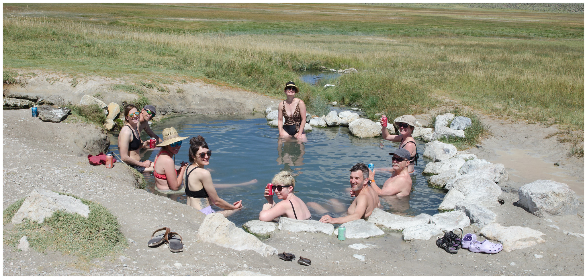
The next morning I woke to a motel room draped floor-to-ceiling with wet gear. We gathered for breakfast burritos at the most instagramable marketeria we’d ever been to and extended our streak of exquisite Mexican food. Feeling “planned out”, I ceded control of the day and was so happy to follow Erin and Jared to Willy’s Hot Springs, soundtracked by Usher. What was originally planned to be a long slog of >4000 feet up Mono Creek instead turned into a long soak in a perfect spring. Stories were told and, eventually, goodbyes were said, as our party started to peel off like the epilogue to Return of the King.
Da, Betty, Michael, Sara, Adrienne and I stayed one more night in Bishop, plotting what it would take to move to this town that we quickly grew to adore. We met some delightful local businesspeople (making us feel guilty about scheming to drive them out of business and steal their marketshare) and saw one of the worst movies (Meg 2) I’ve ever paid for at the local historic theater. Back at the hotel, we stayed up on the pool patio with the last of our beverages and a quest for the “perfect Jeopardy card” (i.e., no misses). I felt like I had found the fountain of youth when the night manager of the hotel came out to relay that he’d received a noise complaint. He also explicitly told us that he knew that the complaint was ******** and directed us to where we could continue with our revelry. That guy knew how to party. We capped the night…by completing a perfect Jeopardy card.
8/22
Betty and Da hit the road after a redux of our marketeria experience (this time we tried the breakfast quesadilla!). Sara, Michael, Adrie, and I then delved into the touristy-but-worth-it Erick Schat’s Bakery for some road trip provisions before also saying our goodbyes. And then there were two. Adrienne plotted a course for Great Basin National Park and proceeded to drive the width of Nevada. Adrienne alerted me to each ghost town we drove by, we crossed a couple of dozen mountain ranges, and I may have tapped the breaks three times over six hours of beautiful desert driving. Over the next few days we camped in an aspen grove, climbed Wheeler Peak (a new elevation PR for Adrienne, over 13,000 ft), took a limestone cave tour, watched storms build and dissipate into rainbows, and visited the oldest living non-clonal organisms on earth (Bristlecone Pines). Continuing our circuit of Nevada, we then drove back across the Great Basin (the ecoregion/drainage, not the park) to return to my mom’s house in Chiloquin. The next day we drove up to Crater Lake, which Adrienne hadn’t seen and I hadn’t been to since high school, and had an all-around wonderful visit with my Mom, including an incredible tag-team Carne Asada dinner. Jed’s fur had never been so soft, with his spa regimen of twenty dips in the river per day. We were on such a hiking roll that we stopped at Crater Lake again on our way north to hike Mt Scott (the high point in the park). A great trip. A great way to ring in 40 years.

