Hello! I am heading out on a 4 night trip in Ansel Adams Wilderness this weekend and am looking for any available intel on recent conditions. I'm starting from Agnew Meadows, taking the Shadow Creek trail, and staying at Ediza, Thousand Island, and Davis Lakes. I've been monitoring r/JMT, High Sierra Topix, AllTrails, and Sentinel but haven't seen any new reports within the last week. Can anyone share more recent conditions for these areas?
In particular, I've heard of some potential snow and sketchy conditions along Shadow Creek up near Ediza. Also a short but steep snow covered section on the JMT on the northeast side of Garnet with potential runout into the lake. That's pretty much all I've heard about as of the end of July. If anyone has recent reports on these sections, can you please share?
Also, I originally wanted to hit Marie Lakes Basin after Thousand Island but that area may still be covered in snow. It looks like the trail up to Marie Lakes is steep and on the north side of a ridge. For those reasons, I think Davis Lakes would be much easier but I'd appreciate thoughts on that as well.
Thanks in advance!
Recent conditions for Ediza, Garnet, Thousand Island?
-
amtoyama

- Topix Newbie
- Posts: 1
- Joined: Wed Jul 19, 2023 11:41 am
- Experience: Level 3 Backpacker
-
SSSdave

- Topix Addict
- Posts: 3524
- Joined: Thu Nov 17, 2005 11:18 pm
- Experience: N/A
- Location: Silicon Valley
- Contact:
Re: Recent conditions for Ediza, Garnet, Thousand Island?
Look at the latest Sentinel Hub satellite images to understand where snow still exists. And yes there still is a lot at higher, less sun exposed elevations.
-
mildandgreen
- Topix Novice
- Posts: 13
- Joined: Sat Aug 29, 2020 8:13 am
- Experience: Level 4 Explorer
Re: Recent conditions for Ediza, Garnet, Thousand Island?
I'll tag on to this regarding the same area to ask if anyone has crossed from Iceberg over to Cecile Lake - it looks very snowy. Even though the elevations aren't much over 10,000 there seems to be a lot more snow tucked up there.
-
vagabondmountainman
- Topix Novice
- Posts: 7
- Joined: Wed Aug 30, 2017 1:23 pm
- Experience: Level 4 Explorer
- Location: Monterey, CA
Minaret-Cecile-Iceberg-whitebark pass-garnet-1000 island
Hi I just got back from there last night. You won't have any trouble at all if you're on the trails. I did as much off trail/ Sierra high route as I could from the Minaret lakes trailhead north. Plan originally was Minaret lakes to Tuolumne Meadows via Cecile, Iceberg, Whitebark pass to Garnet, 1000 island lakes, then over N. Glacier pass to Twin Island Lake and Bench Canyon then over Blue Lake pass and down to Yosemite. I ended up only going to 1000 island lakes though due to snow. I will copy/paste this into a new heading for the area in case anyone is headed that way.
Going up the trail to Minaret lakes there were no issues other than a knee deep stream crossing along the JMT within the first couple miles of trail-- you would avoid this on the Agnew meadows trailhead. On the JMT an easy crossing was made anywhere upstream of the normal crossing--I went about 3/4 mile up just a bit below Johnston meadow and it was very cold but less than knee deep. The rest of the way up to Minarets was easy with just a couple of pretty flat grade snowfields. Up around Minaret lakes the snow fields were present in shady areas and on a lot of the steeper slopes going down into the lakes but it was still possible to navigate around lakes and there were plenty of good campsites. Fishing good as well. Wildflowers in the early stage of bloom around minaret lakes, and hummingbird moths were everywhere, really fun to watch. Waterfalls all high flowing and pretty
Going from Minaret up to Cecile and over to Iceberg was definitely more difficult than usual but doable. Rather than going up the slope along the waterfall from the West side of minaret lake, i usually go up the waterfall that goes from the North End of the lake down into the tiniest of the Minaret lakes and then cut left/ North west about halfway up the slope which takes you through an easy slot and comes out about a third of the way up the shore of Cecile rather than at the South end. That slot is just easier to navigate for me and seems to save time. I'm glad I went that route this trip because the South end of Cecile lake was completely snowbound and it looked like the slopes might have been steep and a little slippery coming up that way. The path might have even been blocked by snow at top, but I didn't walk around to look. From where I came out though it was an easy walk around Cecile on snow but it was careful route finding to get down to Iceberg lake from there. Very steep snow fields along the entire face down to Iceberg lake. If you take your time though and find the waterfall at the outlet of Cecile, there was a route down pretty much entirely on talus and screen down to the bottom by starting on the right side of the waterfall/outlet pointing down. I couldn't find the spot to go down there so I ended up going down starting on the left side of the waterfall and crossing it about 200 feet down, but I would recommend starting on the right side. From the top of the right side of the outlet you're able to pick your way down class 2/3 rock slopes and then take the zigzaggy trail down the loose scree and unstable talus to the bottom. At the bottom the snow was soft enough by around noon to cut over around iceberg lake. Iceberg lake was completely iced over though other than a couple of small sections along the shore and part of the outlet.
Iceberg-Garnet via Whitebark pass-- the route was not difficult on the Iceberg/Ediza lake side and I would still recommend it as a nice day hike but would not recommend going over the pass at the moment without crampons and an ice axe unless you are really comfortable on steep snow. The route up through the pass was very pretty with wildflowers just starting to bloom around all of the streams coming down from the top. More stream crossings than usual but no trouble getting across any of them on rocks without getting your too wet. Following the right side of the major stream coming down from the pass it was easy to get up to the top and there weren't too many snowfields until you get to the Nydiver Lakes area. From there it was intermittent snow all the way up to the pass. At the top of white mark pass was more snow than I've ever seen all the way across. I think the safest way to go down would have been to go one to 3 notches over and try to find a completely snow free route down to Garnet lake. I've never gone that way though and not sure if you would get cliffed out or not. I plan on exploring it next trip. I ended up trying a route down at the far right side of white bark pass which is usually snow free but not really this year. It was possible to scramble down a steep stretch of unstable tallus about six feet wide where the snow had partially melted away at the rock cliff on the right. The snow was overhead height to the left, so you can't get out except at the top or bottom once in there. That took me down the first 50-100 or so vertical feet, and from there I was able to climb out of the snow and then to a short snow crossing to another clump of boulders about 6 feet diagonally away and then do another crossing of about 20 or 30 feet down and diagonal to where I could take a talus field safely down about halfway down the slope to where the snow was manageable. The snow is still very steep up there and I would not recommend that route without an ice axe, spikes/crampons and lots of snow experience, because if you mess up it's a long way down a steep slope before you would stop and I think you would end up sliding a long way into rocks at high speed. It was too steep to stand up safely on that grade without ice/axe and crampons so I went on my butt, kicking steps and using my poles for support, but still ended up sliding about halfway across the last crossing. I had it lined up so that I would go into the rocks, and picked up a little bit of speed before shooting feet first into a couple big boulders at the top of the talus slope, bouncing over and ripping my pants on the rocks. From there I able to stand up and walk down the 1/2 stable/ 1/2 unstable talus slope that gets you down the rest of the steepest part of the slope. It was an easy diagonal walk from the bottom of the talus slopes over to the shore of Garnet lake.
Again I would not recommend the route to most people though or would do it again myself under those conditions. Much easier and safer to just take the trail from Ediza over to Garnet.
I camped on the Southeast side of garnet lake which had intermittent snowfields but plenty of good places to camp. North side of the lake was almost completely snow free. Fishing good there as usual. Lots of mosquitoes though.
Going from Garnet lake over the little pass offtrail to 1000 island lake was no problem. I took the route around the southwest part of the lake up the right side of the waterfall. From there it was an easy climb up the talus to the top and there was just a little bit of snow fields to cross before hitting the tower slopes down the other side but the snow fields there were not steep and were very easy to cross. It was also possible to do it almost entirely on rock if you wanted to but the snow was an easy crossing. 1000 island lake was completely thawed but lots of snow fields intermittently around the southeast side. Good camping though and decent fishing as well.
I climbed from the southwest side of 1000 island lake most of the way up to north glacier pass and saw a huge buck as well as a coyote with a young pup which was pretty cool. The approach to north glacier pass was entirely snow though for at least the last 1.5 miles and the snow going up to the pass on the final approach looked really steep from a distance. I was going to go up as far as it was safe and through the pass if possible, but a lightning storm came up just as I was starting on that last mile and turned me around back to the lake. The next day was predicted to have a lot of lightning as well so I ended up deciding not to attempt it again. My guess is the route down to and around lake Catherine would have been very difficult due to the steep snow slopes there which probably would have been icy. I'm guessing like Catherine would have been completely iced over but if not I definitely wouldn't have wanted to slip down the slopes into the lake. Also would not have attempted to go down the other side of the pass by the waterfall if snow/ice were present toward twin island lakes as that area is very slippery and steep even without snow or ice.
In summary, i don't think you have any trouble at all going from the trailhead to Ediza, and taking the trail over to garnet and 1000 island lakes. I ran into plenty of people who had came and gone that way and said there were no difficulties on the trail. I came out from 1000 island back on the river trail to Agnew Meadows. it was an easy walk as well. If you go to a Ediza I would recommend walking up and camping around Iceberg because it will be less boggy. I would not recommend going over white bark pass for at least a few more weeks though. Mosquitoes were ever present from the trailhead through the entire section. They were particularly bad at Garnet and 1000 island lakes. I think there was a hatch after the rain storm on Tuesday which made them even worse. I treated my clothing before the trip with Permethrin and sprayed some 100% deet on my exposed skin, otherwise just wore biteproof nyon everywhere and my beard and sunglasses kept them off my face. They were not an issue at all while hiking but swarms quickly surround you whenever you stop, especially near trees or without a breeze. I managed to get through the one week trip with only two bites--they got me on my butt when I was going to the bathroom. They were a constant annoyance though, always in your face and swarming around even if they weren't landing on you making cooking, eating, fishing and book reading a lot less fun than normal. The snow and mosquito conditions reminded me much more of a late June early July trip in a normal big snow year. I had planned on continuing on to Yosemite at least on the Muir Trail for a few more days, but decided to to end the trip early has it seemed to be raining at least twice a day and that mixed in with the mosquitoes and very muddy trail conditions and difficult cross country travel made me ready to take a break after a week. The scenery was beautiful though and definitely worth it, just be careful with you route choice. I did not need my headnet for mosquitos personally, but walking the trails it looked like I was headed to a beekeepers convention as pretty much everyone else was netted up all the time.
First time posting here--though I've been a member for a couple years. I'd add some pictures of the snow and lakes, but unsure how. Also sorry for punctuation/spelling errors. I dictated most of it.
-
sbennett3705

- Topix Acquainted
- Posts: 51
- Joined: Fri Feb 25, 2022 1:44 pm
- Experience: Level 3 Backpacker
Re: Recent conditions for Ediza, Garnet, Thousand Island?
Thanks vagabondmountainman, great report. Will finally there Monday with my Son, his first time in the Sierra. Ye hah!
-
jwaldrop71
- Topix Newbie
- Posts: 1
- Joined: Fri Aug 18, 2023 3:49 am
- Experience: Level 4 Explorer
Re: Recent conditions for Ediza, Garnet, Thousand Island?
Headed there Saturday, mildly worried about the weather from the hurricane - forecast is a little grim. Will report back how it goes. 

-
David_Caruso
- Topix Acquainted
- Posts: 25
- Joined: Fri Jun 26, 2020 5:30 pm
- Experience: Level 4 Explorer
Re: Recent conditions for Ediza, Garnet, Thousand Island?
Similar boat as others. Have a permit for this Sunday for Devils Postpile north JMT and had planned on similar routes as you all above.
Hopefully it hits the area mostly Sunday night into early Monday, just sleep in and bring a book if I'm stuck in the tent most of Monday.
I'm following this and they updated it at 11am today (Friday 8/18)
https://www.wpc.ncep.noaa.gov/#page=ovw
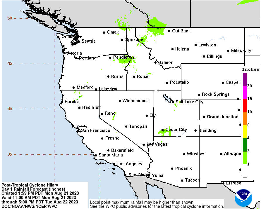
Looks like Mammoth Lakes/Ansel Adams in the line between pretty bad and bearable.
Hopefully it hits the area mostly Sunday night into early Monday, just sleep in and bring a book if I'm stuck in the tent most of Monday.
I'm following this and they updated it at 11am today (Friday 8/18)
https://www.wpc.ncep.noaa.gov/#page=ovw
Looks like Mammoth Lakes/Ansel Adams in the line between pretty bad and bearable.
Who is online
Users browsing this forum: No registered users and 50 guests