I've written a report on a three day trip through Kaweah Basin which is posted at: http://www.sierrahiker.com/KaweahBasin/index.html
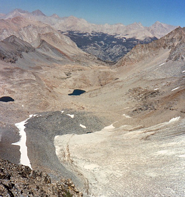
Some photos show the upper reaches of Picket Creek.
Taking the steep chute at the top of Kern Kaweah Col, aka Pants Pass, could result in death if you had a misstep.
Another photo of upper Picket Creek and its cool glacier is at: http://www.sierrahiker.com/TripleDivideLoopI/td12.jpg
The photo was taken from the top of the cirque headwall which is a cliff.
Even though the route from Nine Lakes Basin to Kaweah Basin over Pants Pass is remote and pretty cool, I've only taken it twice.
Trip Plan Feedback: Kaweah Group
-
sekihiker

- Founding Member
- Posts: 959
- Joined: Sun Dec 18, 2005 2:47 pm
- Experience: Level 4 Explorer
- Location: Fresno
- Contact:
-
shtinkypuppie

- Topix Acquainted
- Posts: 62
- Joined: Wed Jun 11, 2014 4:15 am
- Experience: Level 3 Backpacker
Re: Trip Plan Feedback: Kaweah Group
Maverick,maverick wrote: ↑Thu Jan 05, 2023 1:15 pm When going over Pants Pass to the lake below it and then heading south towards the glacier, I did find a route that put me to your proposed Camp 4, but it takes some route finding and some climbing, so I would not advise.
To me the highlight of the Kern-Kaweah River is the section where you are planning to start up to Camp 3, I would skip that whole section, maybe do as a day hike up it, if you really want to see it.
I would recommend instead, that you go up to the lower Kaweah Lake (Island Lake) from the Rock Slide Lake area by following the creek up, not to closely, and base camp.
The next day hike over and into the Pickett Creek drainage and down to lower Pickett Creek Lake.
The following day climb over the shoulder of Red Spur, directly south of your basecamp, into Red Spur Lakes Basin, beautiful lakes and scenery that are very rarely visited.
The following day make a decision to either go up higher into KB to set up camp or continue doing day hikes into different sections of upper KB for the rest of the time you have left.
If, this wet pattern continues and we end up having very high snow percentages, then you may not be able to do this trip till mid August or later, unless you are comfortable with some snow travel, but even if you are, it would slow you down and significantly cut back on the time you will have to visit some of these locations.
Thanks for that. I have seen conflicting reports about the ascent from Kern-Kaweah to Kaweah Basin, with some people calling it easy and others saying it's difficult and cliffy. Opinions seem to be unanimous on the 'diagonal' approach from a little higher on the Kern-Kaweah being relatively easy slab-walking. Do you have an opinion?
I have decided to add a Red Spur day hike to my itinerary, so thank you again!
"It is a wholesome and necessary thing for us to turn again to the Earth, and in contemplation of her beauties to know wonder and humility"
- Rachel Carson
- Rachel Carson
-
shtinkypuppie
- Topix Acquainted
- Posts: 62
- Joined: Wed Jun 11, 2014 4:15 am
- Experience: Level 3 Backpacker
Re: Trip Plan Feedback: Kaweah Group
Cameron,cgundersen wrote: ↑Wed Jan 04, 2023 8:43 pm Hi Shtinky,
From your proposed camp3, you really do not need to backtrack. Both those ridges to the south and southeast are perfectly "doable", but once you get into that basin to the south (Picket Guard basin?), there is absolutely no flat ground till you get down to the lakelet where you have camp4. It's incorrigibly rocky. OK hiking, just sucks for camping. From the camp 4 area into Kaweah basin is a snooze and there are gobs of ponds scattered all the way up Kaweah basin, so if you are not fishing, several of them offer adequate spots to park. I've seen some desultory comments about Kaweah basin, but I love the place, so it's worth finding out how it strikes you (some of the earliest posts I saw on HST were from Mav and Trailblazer/Greg Cope and their trips to Kaweah basin and they were very enthusiastic! Cameron
I have scrutinized the routes between the Kern-Kaweah headwaters and Picket Creek, but all of them seem a bit rich for my blood. I try to stick to Class 2 passes; probably the hardest passes I've done were Feather and White Bear and I'd like to keep it that way. If there's a good class 2 route from upper Kern-Kaweah into Picket, I'm all ears.
"It is a wholesome and necessary thing for us to turn again to the Earth, and in contemplation of her beauties to know wonder and humility"
- Rachel Carson
- Rachel Carson
-
shtinkypuppie
- Topix Acquainted
- Posts: 62
- Joined: Wed Jun 11, 2014 4:15 am
- Experience: Level 3 Backpacker
Re: Trip Plan Feedback: Kaweah Group
Thank you! I had actually stumbled upon your excellent photoessay while initially planning this trip. I have added the lower Kaweah Lake to my plan.CAMERONM wrote: ↑Wed Jan 04, 2023 11:02 pm From my trip in 2017, the Kaweah Basin and the last Picket Guard Lake were the highlights. I found the whole northern section around your camp 3 to be boring and stark. I did not find Picket Guard Pass to be scary or exposed, but it is certainly class 3. That lower lake in the Kaweah Basin you miss is a nice one. I would save a day or two and not bother with the north section. I was sorry that I did not climb Picket Guard Peak, but I was surgically focussed on a shorter trip which I cut back by two days when I learned of an impending storm. I remember Daisy posting about getting caught in that storm the next day. My trip:
https://www.trailnamebackstroke.com/kaweah-basin
In your website you say "The climb down proves to be straightforward, but these kinds of rocks can be tricky as there are huge vertical sections of smooth rock that are impassible." Above that passage is a picture of a very impassable-looking wall. Did you descend that? What class rating would you give your descent?
"It is a wholesome and necessary thing for us to turn again to the Earth, and in contemplation of her beauties to know wonder and humility"
- Rachel Carson
- Rachel Carson
-
Wandering Daisy

- Topix Docent
- Posts: 6691
- Joined: Sun Jan 24, 2010 8:19 pm
- Experience: N/A
- Location: Fair Oaks CA (Sacramento area)
- Contact:
Re: Trip Plan Feedback: Kaweah Group
Given the remaining snow at this point, it would not surprise me if snow lingers in the gullies both sides of Pants Pass or even a cornice. You did not say when you were going. I would try later, perhaps September. With all the road closures in SEKI, there will be a great demand on permits for the fewer trailheads. Good luck!
-
shtinkypuppie
- Topix Acquainted
- Posts: 62
- Joined: Wed Jun 11, 2014 4:15 am
- Experience: Level 3 Backpacker
Re: Trip Plan Feedback: Kaweah Group
Funny you should ask...Wandering Daisy wrote: ↑Fri May 26, 2023 9:06 am Given the remaining snow at this point, it would not surprise me if snow lingers in the gullies both sides of Pants Pass or even a cornice. You did not say when you were going. I would try later, perhaps September. With all the road closures in SEKI, there will be a great demand on permits for the fewer trailheads. Good luck!
I had planned this trip for June 10, hoping for a repeat of last year when I was wandering around Woods Lake on the 1st of June. I was able to bump it to another window of time off starting July 20. I am entering over Cottonwood Pass, and approaching from Junction Meadow and the Kern-Kaweah, so there are no high passes to cross - as long as the basins are melted out and the Kern isn't TOO raging, I am hopeful the trip will go... but realistic about it very possibly not.
"It is a wholesome and necessary thing for us to turn again to the Earth, and in contemplation of her beauties to know wonder and humility"
- Rachel Carson
- Rachel Carson
-
maverick

- Forums Moderator

- Posts: 11844
- Joined: Thu Apr 06, 2006 5:54 pm
- Experience: Level 4 Explorer
Re: Trip Plan Feedback: Kaweah Group
Here is a screenshot of that route. Personally, I would do this trip in late August or early September this year, unless we get a good monsoonal flow that would expedite the melt in the high country.
https://www.highsierratopix.com/communi ... w&id=37882
https://www.highsierratopix.com/communi ... w&id=37882
Professional Sierra Landscape Photographer
I don't give out specific route information, my belief is that it takes away from the whole adventure spirit of a trip, if you need every inch planned out, you'll have to get that from someone else.
Have a safer backcountry experience by using the HST ReConn Form 2.0, named after Larry Conn, a HST member: http://reconn.org
Who is online
Users browsing this forum: Bing [Bot] and 13 guests