Just learned about this 45-50 mile loop and sounds pretty cool summer trip option.
Anyone here ever do this loop? Any advice? And if so, few q's:
1 - Where is first few reasonable spot one can camp with water once out of Mist Falls area? It sounds like its more like 7-8 miles out and not just beyond the 4 mile limit. We may have a late start Day 1 so judging how far we will need to push it.
2 - Red Peak - anyone know the snow pack and how late it typically hangs on in an average year? When is reasonably safe to trek over in a given year? We're likely headed mid-July and I am not huge into snow trekking.
Happy Isles - > Illouette -> Red Peak -> Merced Loop Question
-
sambieni

- Topix Regular
- Posts: 303
- Joined: Sat Feb 13, 2016 11:24 pm
- Experience: Level 2 Backpacker
Happy Isles - > Illouette -> Red Peak -> Merced Loop Question
Last edited by sambieni on Mon Feb 07, 2022 8:08 pm, edited 1 time in total.
-
TehipiteTom
- Founding Member
- Posts: 953
- Joined: Thu Aug 24, 2006 8:42 am
- Experience: Level 4 Explorer
Re: Happy Isles - > Illouette -> Red Peak -> Merced Loop Question
I did Red Peak Pass on July 21, 2009 (an 82% of "normal" snow year, according to the April 1 SWEQ) and there was snow on the north side, but nothing I couldn't navigate comfortably (and I'm a snow wimp). A couple photos below to give a general feel. Just one data point, for whatever it's worth; you'll want to keep an eye on the SWEQ summary to see how this year compares. .
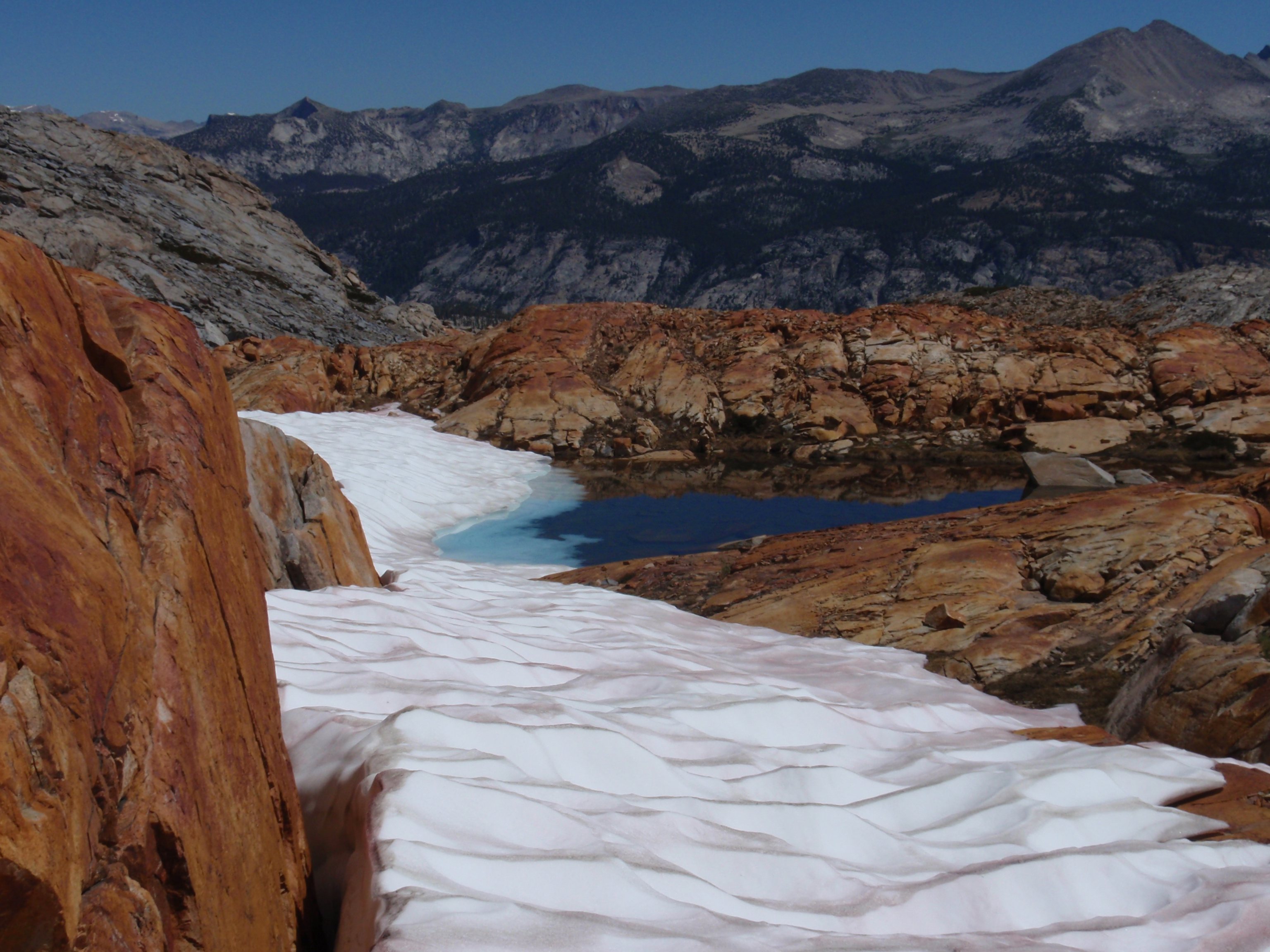 Icy Tarn
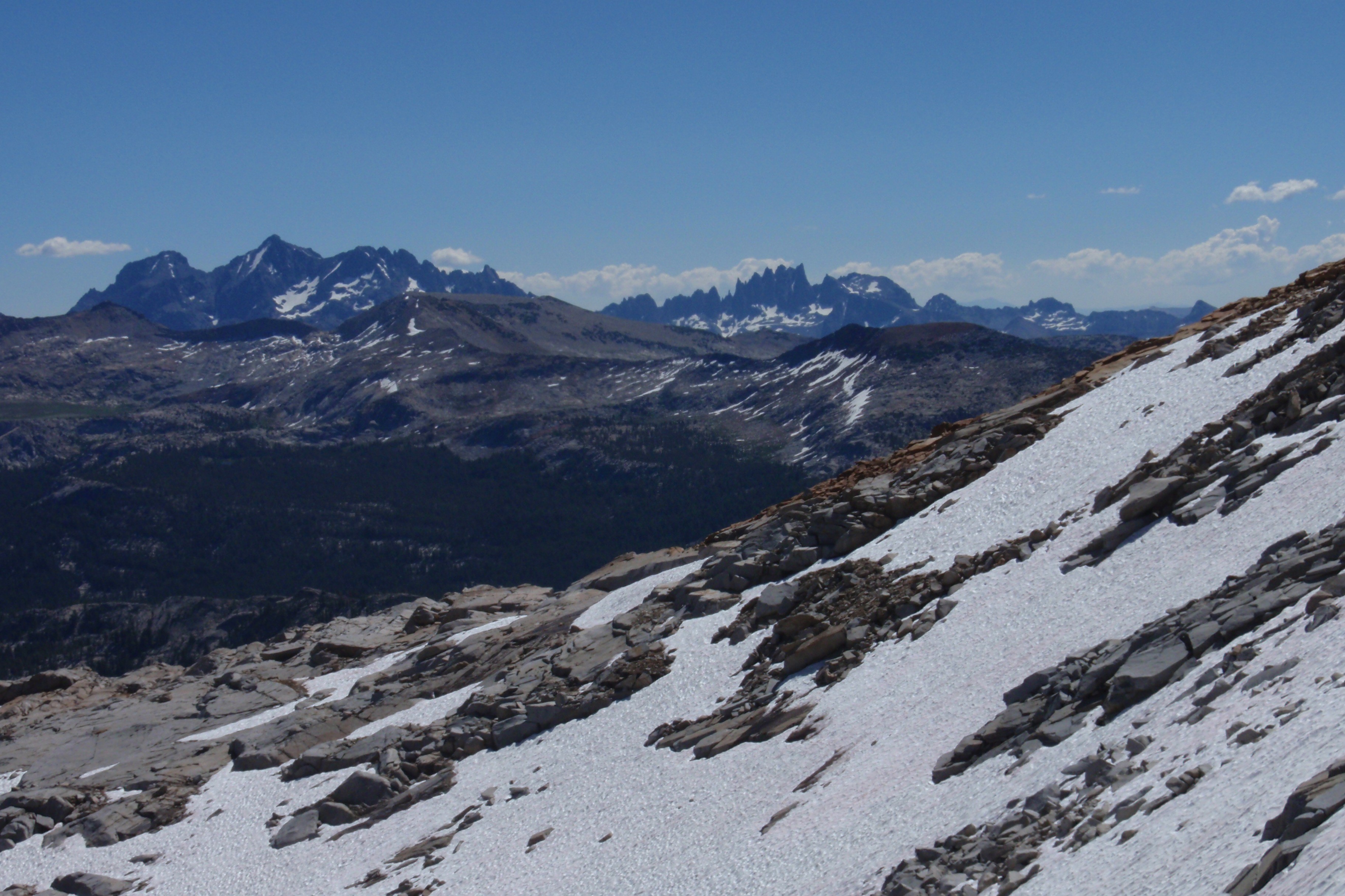 Minarets 01
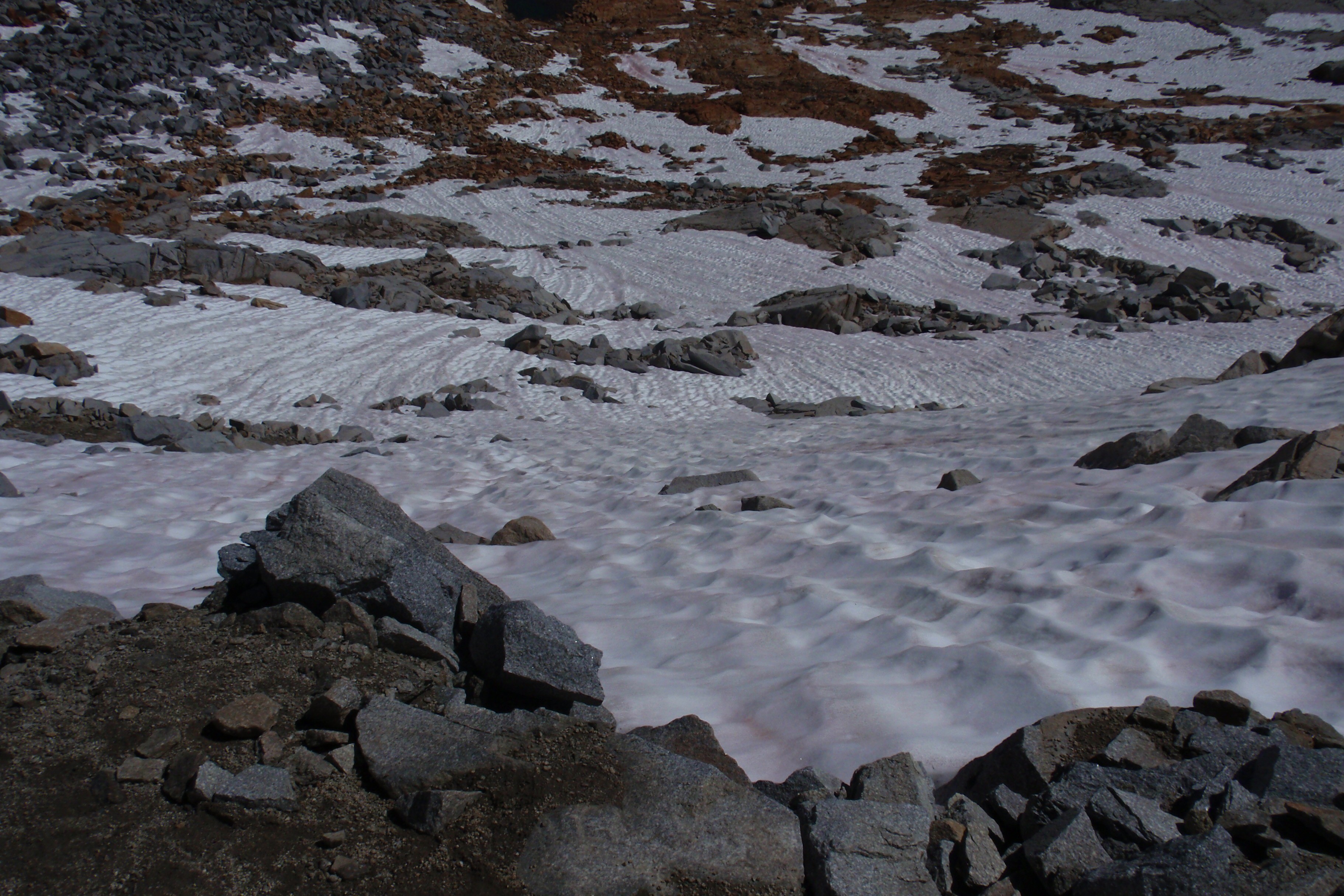 Snowfield
Icy TarnMinarets 01Snowfield-
druid
- Topix Regular
- Posts: 138
- Joined: Mon Aug 08, 2011 12:50 pm
- Experience: N/A
Re: Happy Isles - > Illouette -> Red Peak -> Merced Loop Question
Here are some pictures of the NE side of the pass from July 27, 2011 (a 162% SWEQ year on April 1). On the other hand, in a low-snow year, you might have to hunt around to find any snow at all by the end of July.
In short, it's too early to tell. Keep your eye on the monthly snow reports.
In short, it's too early to tell. Keep your eye on the monthly snow reports.
You do not have the required permissions to view the files attached to this post.
-
bobby49
- Topix Fanatic
- Posts: 1238
- Joined: Sat Nov 11, 2017 4:17 pm
- Experience: Level 4 Explorer
Re: Happy Isles - > Illouette -> Red Peak -> Merced Loop Question
I've been to or through Red Peak Pass a couple of times. If I was doing it again, I would time it to get to the pass just before the last snow melts off the trail from Ottaway Lakes. Why? The new grass is shooting up, and that's when the pikas come out to harvest grass. That's only good if you do wildlife photography and have a decently long camera lens.
-
robow8

- Topix Regular
- Posts: 343
- Joined: Wed Nov 13, 2013 5:17 pm
- Experience: N/A
Re: Happy Isles - > Illouette -> Red Peak -> Merced Loop Question
https://caltopo.com/m/UKN1R
I've camped at both of these spots. The Southernmost one is nicer, and where we camped had some obsidian flakes around. The Nothern spot was up on a spot above the trail. Water was fairly close for both of them.
I've camped at both of these spots. The Southernmost one is nicer, and where we camped had some obsidian flakes around. The Nothern spot was up on a spot above the trail. Water was fairly close for both of them.
-
Wandering Daisy
- Topix Docent
- Posts: 6694
- Joined: Sun Jan 24, 2010 8:19 pm
- Experience: N/A
- Location: Fair Oaks CA (Sacramento area)
- Contact:
Re: Happy Isles - > Illouette -> Red Peak -> Merced Loop Question
There are streams that come off the Star King ridge. They dry up later but should have water early to mid-season. Last resort late season is where the upper trail gets close the Illouette Creek.
The stretch from Panorama Trail to Ottoway Lakes is pretty boring. I walked this as approach to climbing Mt Clark. There are other ways to get to Red Peak.
You could go up to Washburn Lake, x-c up Red Devil Cr, overnight side trip over Red Peak Pass to Upper Ottoway, back on the trail to Echo Valley, cross trail to JMT and back. I went up Red Devil Creek as part of a longer trip in 2011. It is a bit gnarly. Main thing is you have to be able to cross the river, which means late season trip. I actually dropped down from Tuolumne Meadows. Again, another late season trip.
In 2006 I did a 7-day, 56-mile loop from Fernandez TH that included Ottoway Lakes and Red Peak Pass. 1) Stanford L 2) Breeze Lk 3) U Ottoway 4) Turner Lk w side trip Edna Lake 5)over Isberg Pass to Porphrey L 6) off-trail traverse past many lakes to Chittenden L 7) half day out to TH. Edna Lake is very stunning but no camping. Not sure what the recent fires have done to Fernandez TH area. Permits are no problem at this trailhead. And I encountered very few people.
Here is a nice camp at Upper Ottoway L on a grassy peninsula- a short off-trail distance.
You do not have the required permissions to view the files attached to this post.
Last edited by Wandering Daisy on Tue Feb 08, 2022 9:24 am, edited 3 times in total.
-
robow8
- Topix Regular
- Posts: 343
- Joined: Wed Nov 13, 2013 5:17 pm
- Experience: N/A
Re: Happy Isles - > Illouette -> Red Peak -> Merced Loop Question
Here's the Northernmost one:
And here's the Southernmost one:
You do not have the required permissions to view the files attached to this post.
-
sambieni
- Topix Regular
- Posts: 303
- Joined: Sat Feb 13, 2016 11:24 pm
- Experience: Level 2 Backpacker
Re: Happy Isles - > Illouette -> Red Peak -> Merced Loop Question
Thanks all. Very helpful.
My buddy and I are both 2/2 backpackers. We've done Mostly on trail backpacking trips w the very rare x-country. Done some passes.
We did Deadman Canyon a few years back so this feels like a good trail option if we think we can do the snow over Red Peak late July.
My buddy and I are both 2/2 backpackers. We've done Mostly on trail backpacking trips w the very rare x-country. Done some passes.
We did Deadman Canyon a few years back so this feels like a good trail option if we think we can do the snow over Red Peak late July.
-
kpeter

- Topix Fanatic
- Posts: 1450
- Joined: Mon Jan 04, 2010 1:11 pm
- Experience: Level 3 Backpacker
Re: Happy Isles - > Illouette -> Red Peak -> Merced Loop Question
I did a loop over Red Peak Pass but started from Glacier Point Road rather than from Happy Isles. This TR might help you. If you can arrange your trip around taking the park bus you can start high at Glacier Point and end low at Happy Isles.
https://www.highsierratopix.com/communi ... il#p110478
Glacier Point to Illouette and Panorama to Illouette was largely a brushy overgrown burn area. Unless they have trimmed the trails you will definitely want long pants.
It starts getting nicer the further along you go. There is good camping where the Clark Fork and Red Creek Cross the trail. I liked the hike from there along Illouette Creek up to Merced Pass Lakes and especially from there up to Ottoway. Personally I much prefer Lower Ottoway to Upper--there is a nice open canopy of treecover around parts of Lower Ottoway. But my favorite spot on the loop was Red Devil Lake and the headwaters of the Merced.
-
balzaccom
- Topix Addict
- Posts: 2970
- Joined: Wed Dec 17, 2008 9:22 pm
- Experience: N/A
Re: Happy Isles - > Illouette -> Red Peak -> Merced Loop Question
We should note that the Glacier Point Road will be closed all of 2022--at least, that is the situation for now.
Check our our website: http://www.backpackthesierra.com/
Or just read a good mystery novel set in the Sierra; https://www.amazon.com/Danger-Falling-R ... 0984884963
Or just read a good mystery novel set in the Sierra; https://www.amazon.com/Danger-Falling-R ... 0984884963
Who is online
Users browsing this forum: No registered users and 37 guests