Hello,
Planning a trip to the Tablelands this summer. Already got our permit for July and cant' wait to start heading back to the High Sierras. I will be taking some level 2 (out of 5) hikers alongside so I'm not sure if I'm overshooting it. Here is what the trip entails.
Day 1: Wolverton to Alta Meadow (possible side trip to Alta Peak)
Day 2: Alta Meadow to Lake 11,200
Day 3: Lake 11,200 to Big Bird Peak, down to headwall above Lonely Lake and then Horn Col. Back to 11,200 and then on to Moose Lake
Day 4: Moose lake back to Wolverton via Watchtower Trail
I'm wondering if i'm being too optimistic with Day 2. I figure if I give myself at least 4 hours to cross from Alta Meadow to Moose lake and then another 3 hours from Moose lake to lake 11,200 that should be plenty of daylight to set camp at lake 11,200. Is that realistic?
Also wondering how is the hiking from Big Bird Peak to Horn Col. Can we stay high alongside the headwalll above Lonely Lake so we don't lose too much elevation. Is that doable?
Tableland Navigation Guidance
-
Trailguru

- Topix Acquainted
- Posts: 78
- Joined: Tue Feb 06, 2007 9:46 am
- Experience: N/A
- Location: Southern Cal
-
Wandering Daisy
- Topix Docent
- Posts: 6693
- Joined: Sun Jan 24, 2010 8:19 pm
- Experience: N/A
- Location: Fair Oaks CA (Sacramento area)
- Contact:
Re: Tableland Navigation Guidance
Can you show a map of your route?
-
maiathebee

- Topix Expert
- Posts: 470
- Joined: Tue Jun 18, 2013 11:59 am
- Experience: Level 4 Explorer
- Location: Alpine Meadows, CA
- Contact:
Re: Tableland Navigation Guidance
I'm confused about your route, so I agree with Daisy that a map would be helpful. It's weird to me that you are hopping back and forth around so much on your described route. Like... hike past Moose to 11,200, then leave there for Lonely Lake area, then back to 11,200, then back to Moose... Seems like a lot of unnecessary effort to me.
You might find my trip report from this area helpful.
How much cross country / route finding experience do you have? That will determine a *lot* how efficient you are in this type of terrain. There are lots of microfeatures that make cross country travel in the Tablelands kind of a headache. Even a 10 foot cliff that you didn't see can make you turn around.
Getting to Moose from Alta will probably not take 4 hours. The terrain between Moose and 11,200 is very convoluted and you will probably find yourself backtracking and rerouting unless you are really good at route finding or just find an efficient route by luck. That part will be harder than the part from Alta to Moose.
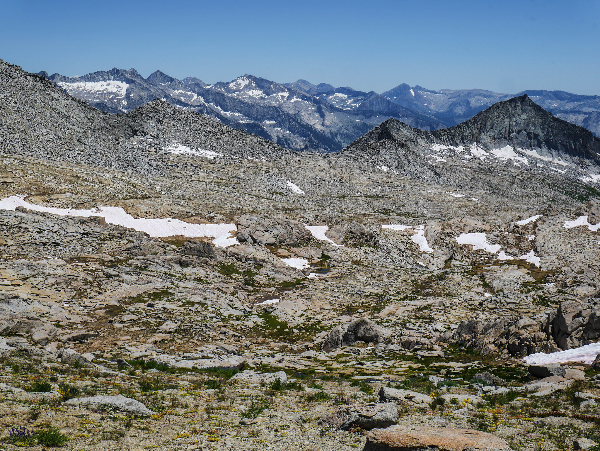
I'm also confused about your day 3. Is it a day hike? How are you getting "back to 11,200"? Are you taking Pterodactyl Pass or going back over Big Bird? For Big Bird to Horn here's a photo that might help. This was taken near the cliffy ridge above Big Bird Lake's basin, N of Horn Col. Big Bird lake is the lake you see on the right, Big Bird peak the big hump above it. I haven't hiked this ridge between where I was standing and Big Bird, but it's definitely easy at least to the saddle. I don't know about the part between the saddle and Big Bird summit.
 Big Bird Peak by Maia Averett, on Flickr
You might find my trip report from this area helpful.
How much cross country / route finding experience do you have? That will determine a *lot* how efficient you are in this type of terrain. There are lots of microfeatures that make cross country travel in the Tablelands kind of a headache. Even a 10 foot cliff that you didn't see can make you turn around.
Getting to Moose from Alta will probably not take 4 hours. The terrain between Moose and 11,200 is very convoluted and you will probably find yourself backtracking and rerouting unless you are really good at route finding or just find an efficient route by luck. That part will be harder than the part from Alta to Moose.
I'm also confused about your day 3. Is it a day hike? How are you getting "back to 11,200"? Are you taking Pterodactyl Pass or going back over Big Bird? For Big Bird to Horn here's a photo that might help. This was taken near the cliffy ridge above Big Bird Lake's basin, N of Horn Col. Big Bird lake is the lake you see on the right, Big Bird peak the big hump above it. I haven't hiked this ridge between where I was standing and Big Bird, but it's definitely easy at least to the saddle. I don't know about the part between the saddle and Big Bird summit.
Big Bird Peak by Maia Averett, on Flickroh hey! you're reading my signature.
that's nice. want to check out my blog?
here it is: plutoniclove.com
ig: @plutonic_love
that's nice. want to check out my blog?
here it is: plutoniclove.com
ig: @plutonic_love
-
creekfeet
- Topix Regular
- Posts: 157
- Joined: Sun Nov 16, 2014 11:54 pm
- Experience: N/A
Re: Tableland Navigation Guidance
The Tablelands is interesting in that as far as the actual hiking goes, it's just about the easiest place for x-country travel. It's never particularly steep, and there's a minimal amount of bushwhacking and talus hopping. However, navigation wise it can be difficult as there's all sorts of micro canyons and such that maps don't do a justice,
Your Day 2 itinerary is definitely doable is everyone is in good shape. However, I'd recommend not climbing Alta Peak the day before to save energy. Personally I've always felt Alta Meadow was a superior destination t0 the peak itself.
From Alta to Moose there's an old trail you can follow that remains in solid condition until the springs indicated on the map. From there it descends into a series of different use trails, and eventually fades altogether. Depending on your navigating and luck, getting to Moose can be a fairly simple affair, or can also prove to be pretty tiring.
Moose to 11,200 can be time consuming, but ultimately it's pretty mellow for an x-country pass. I will caution, doing it in the midday heat can be a little brutal because there's zero escaping the sun on that stretch. Lots of ponds to dip into, though.
Hope you have a great trip!
-
oleander
- Topix Expert
- Posts: 480
- Joined: Wed Aug 18, 2010 10:15 am
- Experience: N/A
Re: Tableland Navigation Guidance
I'd suggest...
1. To Alta Meadow
2. To Moose Lake. This is a half day hike, half day just knocking about, exploring the lake, and taking some of the best "endless pool" photos you have ever seen. This is just not a lake to rush past.
3. Up early, park your tents at 11,200, then go exploring with whatever energy you have left, in any number of directions. You can't lose.
4. Back to trailhead, via Table Meadows. Much of this is very fast walking - easiest part of Tablelands.
-
Trailguru
- Topix Acquainted
- Posts: 78
- Joined: Tue Feb 06, 2007 9:46 am
- Experience: N/A
- Location: Southern Cal
Re: Tableland Navigation Guidance
Hello Maia,maiathebee wrote: ↑Wed May 05, 2021 8:03 pm I'm confused about your route, so I agree with Daisy that a map would be helpful. It's weird to me that you are hopping back and forth around so much on your described route. Like... hike past Moose to 11,200, then leave there for Lonely Lake area, then back to 11,200, then back to Moose... Seems like a lot of unnecessary effort to me.
You might find my trip report from this area helpful.
How much cross country / route finding experience do you have? That will determine a *lot* how efficient you are in this type of terrain. There are lots of microfeatures that make cross country travel in the Tablelands kind of a headache. Even a 10 foot cliff that you didn't see can make you turn around.
Getting to Moose from Alta will probably not take 4 hours. The terrain between Moose and 11,200 is very convoluted and you will probably find yourself backtracking and rerouting unless you are really good at route finding or just find an efficient route by luck. That part will be harder than the part from Alta to Moose.
I'm also confused about your day 3. Is it a day hike? How are you getting "back to 11,200"?
All good questions. The reason why we wanted to dart past Moose Lake and onto lake 11,200 was that it'd set us up closer to the area around Horn Col and possibly Copper Mine pass or the headwall area above Deadman canyon (near Elizabeth pass) for Day 3. Possibly even a summit attempt of Peak 12,345. Then we would come back to around the area near Pterodactyl pass and grab our packs and then head to Moose where we would spend the last night there.
Day 2 would be too short if we were to simply go from Alta meadow to Moose lake only. Alternatively we could aim for Alta Meadow to Moose lake on Day 1 and then take our time with exploring the Tablelands but then part of me feels like that will be too much. (unless you say otherwise)
That whole area seems fairly straight forward when it comes to the navigation part. I've done a decent share of cross country in the sierras such as Miter Basin, Williamson bowl and Potluck pass area so that's not a problem. I do totally agree about the unexpected and undulating nature of the Tablelands being a big drag and that is why I wanted to ask for your thoughts on it. I do think the more I consider the route, what Oleander suggested might be a better choice after all. But just for reference here is what I had in mind:
https://caltopo.com/m/GC77
-
Trailguru
- Topix Acquainted
- Posts: 78
- Joined: Tue Feb 06, 2007 9:46 am
- Experience: N/A
- Location: Southern Cal
Re: Tableland Navigation Guidance
Thanks for the tip Creekfeet! Having a respectful attitude towards Murphy's law I do wanna play it on the safe side and not assume we could get to Moose lake in a short period of time especially with the 6 people in total going on this trip. That being said, I guess some of the folks on our group wanted to spend the last night at Moose lake (more out of idealism rather than practicality) even if it involves a longer travel back to Wolverton than from Lake 11,200 directly down to Wolverton if we were to stay at lake 11,200 on our last day. Although lake 11,200 seems much farther in distance to Pear Lake I read somewhere it's still much faster and straightforward than Moose Lake > Pear Lake. Can you confirm?creekfeet wrote: ↑Wed May 05, 2021 8:54 pm The Tablelands is interesting in that as far as the actual hiking goes, it's just about the easiest place for x-country travel. It's never particularly steep, and there's a minimal amount of bushwhacking and talus hopping. However, navigation wise it can be difficult as there's all sorts of micro canyons and such that maps don't do a justice,
Your Day 2 itinerary is definitely doable is everyone is in good shape. However, I'd recommend not climbing Alta Peak the day before to save energy. Personally I've always felt Alta Meadow was a superior destination t0 the peak itself.
From Alta to Moose there's an old trail you can follow that remains in solid condition until the springs indicated on the map. From there it descends into a series of different use trails, and eventually fades altogether. Depending on your navigating and luck, getting to Moose can be a fairly simple affair, or can also prove to be pretty tiring.
Moose to 11,200 can be time consuming, but ultimately it's pretty mellow for an x-country pass. I will caution, doing it in the midday heat can be a little brutal because there's zero escaping the sun on that stretch. Lots of ponds to dip into, though.
Hope you have a great trip!
-
Trailguru
- Topix Acquainted
- Posts: 78
- Joined: Tue Feb 06, 2007 9:46 am
- Experience: N/A
- Location: Southern Cal
-
Wandering Daisy
- Topix Docent
- Posts: 6693
- Joined: Sun Jan 24, 2010 8:19 pm
- Experience: N/A
- Location: Fair Oaks CA (Sacramento area)
- Contact:
Re: Tableland Navigation Guidance
A map is worth a hundred words! Thanks.
Personally I would drop down to Big Bird Lake and skip Horn Col. Horn Col is a good way to get to Deadman Canyon but not as good a day hike as Big Bird. The lakes above Big Bird are very scenic. And there is wonderful camping in trees at Big Bird outlet. Good fishing too.
A warning about camping at Lake 11200, or anywhere up on the crest of Tablelands. It is very exposed and windy and not the place to be in a thunder storm. Have a backup plan if weather looks threatening.
-
maiathebee
- Topix Expert
- Posts: 470
- Joined: Tue Jun 18, 2013 11:59 am
- Experience: Level 4 Explorer
- Location: Alpine Meadows, CA
- Contact:
Re: Tableland Navigation Guidance
Agree with Daisy that it makes more sense to drop down into the Big Bird lakes than what you currently have planned.
If you do go up Big Bird the way you have then back to Pterodactyl, the part of Big Bird peak between your red and green dots is very steep and cliffy. Navigation could be tricky. Big Bird peak is the peak on the right here. Pterodactyl Pass is the low point between the peaks.
 Big Bird peak + lower gardens as I climb Lonely Lake outlet by Maia Averett, on Flickr
Here's the other side of that same ridgeline. This is taken from around 11,000ft NNW of Big Bird, looking SE towards Pterodactyl
 Looking back at Ptetrodactyl Pass from the ridgeline just NW of Big Bird Peak by Maia Averett, on Flickr
You can get to Moose in a day. I've done it with a hiking partner who was relatively new to backpacking. It's a long day though so start early if you decide to do that. That might satisfy your group's desire to spend time at Moose so you wouldn't have to go back there on your last night.
There's a spectacular campsite on the south side of Moose basically right where you end up when you approach from Alta. This would save a little time vs continuing around to the east shore to camp.
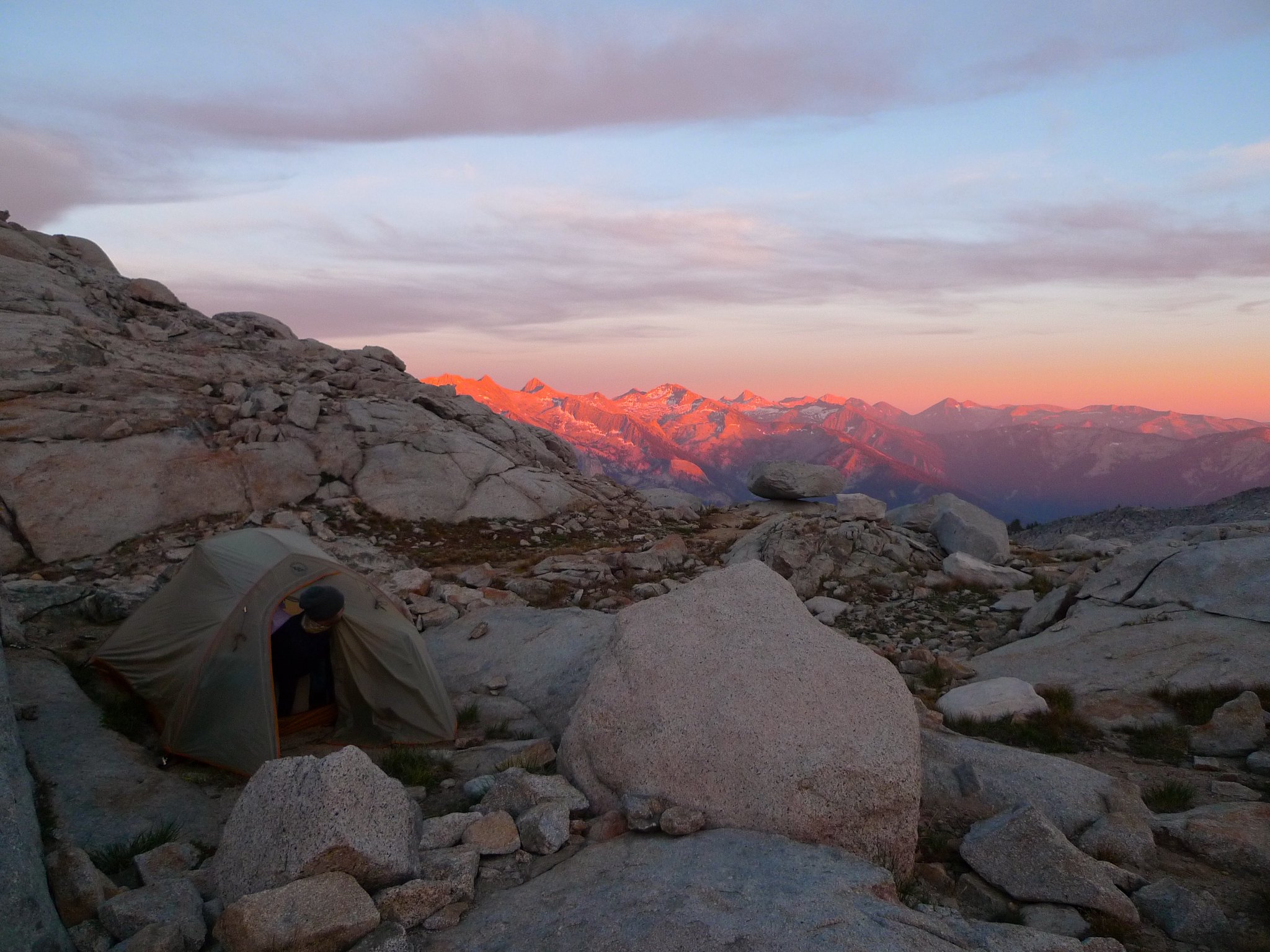 Checking out the alpenglow from our camp at Moose Lake by Maia Averett, on Flickr
You might consider this plan:
Day 1 Wolverton --> Moose via Alta Meadow
Day 2 Moose --> 11,200, set up camp, tag Big Bird Peak
Day 3 Day hike from 11,200 down to Big Bird Lakes, relax and swim
Day 4 11,200 to Pear, relax and swim or climb Alta, return to Wolverton via Watchtower. Pear lake is a great place to be mid-morning after the people who camped there have left but the day hikers haven't arrived yet.
Doing a plan like this gives more flexibility since you have two times where you kinda have a "base camp" and if some of your group don't want to go on the excursions they can just relax at camp.
If you do go up Big Bird the way you have then back to Pterodactyl, the part of Big Bird peak between your red and green dots is very steep and cliffy. Navigation could be tricky. Big Bird peak is the peak on the right here. Pterodactyl Pass is the low point between the peaks.
Big Bird peak + lower gardens as I climb Lonely Lake outlet by Maia Averett, on FlickrHere's the other side of that same ridgeline. This is taken from around 11,000ft NNW of Big Bird, looking SE towards Pterodactyl
Looking back at Ptetrodactyl Pass from the ridgeline just NW of Big Bird Peak by Maia Averett, on FlickrYou can get to Moose in a day. I've done it with a hiking partner who was relatively new to backpacking. It's a long day though so start early if you decide to do that. That might satisfy your group's desire to spend time at Moose so you wouldn't have to go back there on your last night.
There's a spectacular campsite on the south side of Moose basically right where you end up when you approach from Alta. This would save a little time vs continuing around to the east shore to camp.
Checking out the alpenglow from our camp at Moose Lake by Maia Averett, on FlickrYou might consider this plan:
Day 1 Wolverton --> Moose via Alta Meadow
Day 2 Moose --> 11,200, set up camp, tag Big Bird Peak
Day 3 Day hike from 11,200 down to Big Bird Lakes, relax and swim
Day 4 11,200 to Pear, relax and swim or climb Alta, return to Wolverton via Watchtower. Pear lake is a great place to be mid-morning after the people who camped there have left but the day hikers haven't arrived yet.
Doing a plan like this gives more flexibility since you have two times where you kinda have a "base camp" and if some of your group don't want to go on the excursions they can just relax at camp.
oh hey! you're reading my signature.
that's nice. want to check out my blog?
here it is: plutoniclove.com
ig: @plutonic_love
that's nice. want to check out my blog?
here it is: plutoniclove.com
ig: @plutonic_love
Who is online
Users browsing this forum: Google Adsense [Bot], JoeMcIntyre and 18 guests