I'm planning our longish summer trip (mid August) as a 6 day semi-loop out of Florence: up the JMT to Evolution Basin then over from Wanda Lake to Davis Lakes Basin and down to Goddard Canyon. As background, I've been backpacking with my twins (now 12 yrs old) for the last 5 years, we've only done a bit of off trail (e.g. Miter Basin in 2011), but fairly decent hikes on trail (e.g. Onion Valley to Whitney in 2012) and I did a fair amount of off trail stuff (in various parts of Europe) before kids. We would like to do a little bit more off trail this year and the Evolution Basin area looked amazing, so this trip seemed like a reasonable place to start (just two half days off trail, no big climbs/difficult passes), unless anyone thinks that is a really bad choice from the terrain point of view (I realize the route finding is the crux here but I'm comfortable with that).
There doesn't seem to be a lot of information (or many photos) out there about Davis Lakes/Goddard Canyon (I was frustrated to find that Phil Arnot's book describes a completely different Davis Lakes Basin!) though I did figure out the route through the basin - crossing the lake, not following the lakeshore to the outlet, etc.
So I'm wondering if there are any pointers from people who've passed through or camped in Davis Lakes Basin? Is the peninsula (in the middle of the lake) where you cross from the south side to the north side a good camping spot, or is is better to camp higher up the basin? Descending North Goddard Creek how soon would you cut down to the South Fork San Joaquin, or is it better to follow the creek down to nearer the junction? We're not planning to head up to Martha Lake so I'm primarily interested in where the easier slopes and stream crossings will be, rather than saving altitude. Any recommendations about where to camp as you descend Goddard Canyon?
Evolution Basin to Davis Lakes to Goddard Canyon
-
tim

- Topix Expert
- Posts: 516
- Joined: Thu Feb 12, 2009 2:36 pm
- Experience: N/A
- Location: Bay Area
Evolution Basin to Davis Lakes to Goddard Canyon
Last edited by tim on Sun Mar 17, 2013 8:42 pm, edited 1 time in total.
-
John Dittli

- Topix Expert
- Posts: 479
- Joined: Thu Sep 03, 2009 10:38 am
- Experience: N/A
- Location: Crooked Creek
- Contact:
Re: Evolution Basin to Davis Lakes to Goddard Canyon
I've only been there from Wanda and Martha, so I'm of no help with the descent into Goddard Canyon. There is talus dropping down into the lake from Wanda. Great low impact camping just above the upper lake (photo is from below the camp).
I seem to recall the crossing area as being rocky and vegetated, but I may be wrong.
I seem to recall the crossing area as being rocky and vegetated, but I may be wrong.
You do not have the required permissions to view the files attached to this post.
Walk the Sky: Following the John Muir Trail

-
LMBSGV

- Topix Fanatic
- Posts: 1015
- Joined: Sat Oct 27, 2007 8:42 pm
- Experience: Level 4 Explorer
- Location: San Geronimo, CA
- Contact:
Re: Evolution Basin to Davis Lakes to Goddard Canyon
I went from Evolution Basin via Davis Lake down to Goddard Canyon in 2008.
The route over the ridge from Wanda can involve a bit of boulder hopping. I found a nice diagonal chute down to avoid it. But once at the bottom, though it's level, there's still a lot of boulder hopping. Yes, the peninsula is where you cross over to the other side of the lake. There is a campsite on the peninsula itself, but it's not 100 feet from water. There's another right on the other side, but the views are not very good. I camped on the point opposite the peninsula on the other side. You get a wonderful view of the little waterfall from the little creek between the lakes as well as the surrounding peaks.
To get to Goddard Canyon, follow the trail along the right shore after the peninsula. When the next peninsula at the end of the lake begins with the high cliffs above, go overland to the right across the basically level part to bisect the peninsula. There is a fun short descent down to the creek. This is a lovely area. After a bit of wandering around in the area above the creek trying to find a good way to Martha Lake (see the attached trip report if interested in the details), I followed the creek down to Goddard Canyon and camped in the canyon. However, there are a couple of places along the way that would be good campsites, the best being near the big waterfall above the canyon. The waterfall is spectacular, one of those off-trail backcountry sites that would be a tourist attraction if it was near a road.
There are a couple of short sections where the descent along the creek gets a little gnarly, but it's also kind of fun. Also, the wildflowers in a couple of sections were incredibly gorgeous. The descent down Goddard Canyon on the trail is a great, memorable hike. I didn't see anyone until I came across a trail crew. Have a great trip.
My trip report us here:
http://www.sonic.net/~words/Images/TripReport-8-08.pdf" onclick="window.open(this.href);return false;
Photos here (scroll down to the bottom):
http://www.sonic.net/~words/ASITHSTripReports.html" onclick="window.open(this.href);return false;
I don’t need a goal destination. I need a destination that meets my goals.
http://laurencebrauer.com
http://laurencebrauer.com
-
Fishon
- Topix Novice
- Posts: 11
- Joined: Fri Jan 20, 2012 11:18 pm
- Experience: N/A
Re: Evolution Basin to Davis Lakes to Goddard Canyon
I did the trip you are proposing in 2009. Get used to the idea of boulder hopping, take it slow and stay to the right. Here are a few photos of of the Davis Lakes area:
 About to drop into Davis Lakes
 Some perspective on the size of the boulders
 Stay to the right...
Have fun.
About to drop into Davis LakesSome perspective on the size of the bouldersStay to the right...Have fun.
It has always been my private conviction that any man who pits his intelligence against a fish and loses has it coming. -John Steinbeck
-
Electra
- Topix Acquainted
- Posts: 70
- Joined: Mon Aug 06, 2007 4:46 pm
- Experience: N/A
- Location: SF/Yosemite
Re: Evolution Basin to Davis Lakes to Goddard Canyon
I went the opposite direction from goddard canyon thru davis lakes in a very snowy year and camped on the west side of the basin on a peninsula. Very nice but considering the snow, hard to give many details. One thing we did the next day that was different and spectacular was to traverse the ridgeline above sapphire NW and ended up doing a short day and camping on that ridgeline with a superb view of evolution range/valley, muir pass/black giant area, mcgee canyon, etc...We then traversed towards the outlet of Evolution and eventually went over alpine col. Great area that you are sure to enjoy.
Dan Braun
Camp Navarro, Evergreen Lodge & SYMG
Camp Navarro, Evergreen Lodge & SYMG
-
dapperdave
- Topix Acquainted
- Posts: 73
- Joined: Tue Aug 28, 2012 2:07 am
- Experience: Level 4 Explorer
Re: Evolution Basin to Davis Lakes to Goddard Canyon
Hi Tim,
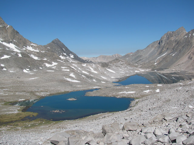
We did a similar trip in Sept 2012, only coming in and out via Lamarck Col; the west side of Davis Lakes Pass (between Wanda and Davis) is a lot of tedious micro-navigation and boulder hopping as people have said, but the view is great consolation. We went north of Davis lake 11196, then south of 11058, then you cross to the north side where the peninsulas join (actually a fast flowing narrow stream between 2 lakes. We cowboy camped on the peninsula on a well-used spot which we persuaded ourselves was 100 ft from water....( there is the "25ft where terrain dictates" getout anyway) Higher up in the basin is very rocky.
Follow the north side of the lake until you go west through the saddle where there are some beautiful tarns -
We headed down to North Goddard Creek and crossed to the south side (20ft wide and ankle deep - however this was September of a low snow year)
There is a pretty decent use trail down the valley, often moving away from the creek, staying on the south side, passing a few campsites and a picturesque fall or two along the way.
The south fork of the San Joaquin was a dry footed crossing for us pretty near to the confluence with North Goddard (again Sep. of low snow year!)
It's a lovely trip, and if you get time, there are lots of side trips to do.
Hope this helps,
Dave
You do not have the required permissions to view the files attached to this post.
-
maverick

- Forums Moderator

- Posts: 11846
- Joined: Thu Apr 06, 2006 5:54 pm
- Experience: Level 4 Explorer
Re: Evolution Basin to Davis Lakes to Goddard Canyon
Hi Dave,
Welcome to HST! Thanks for the great pictures and the info. Looking forward to your
future contributions, and TR's. Mav
Welcome to HST! Thanks for the great pictures and the info. Looking forward to your
future contributions, and TR's. Mav
Professional Sierra Landscape Photographer
I don't give out specific route information, my belief is that it takes away from the whole adventure spirit of a trip, if you need every inch planned out, you'll have to get that from someone else.
Have a safer backcountry experience by using the HST ReConn Form 2.0, named after Larry Conn, a HST member: http://reconn.org
-
dapperdave
- Topix Acquainted
- Posts: 73
- Joined: Tue Aug 28, 2012 2:07 am
- Experience: Level 4 Explorer
Re: Evolution Basin to Davis Lakes to Goddard Canyon
Thanks Mav,
It's a great site. I've lurked forever
Dave
It's a great site. I've lurked forever
Dave
-
tim
- Topix Expert
- Posts: 516
- Joined: Thu Feb 12, 2009 2:36 pm
- Experience: N/A
- Location: Bay Area
Re: Evolution Basin to Davis Lakes to Goddard Canyon
Thanks for all the guidance and the photos. Looks like it should be a great trip through a pretty deserted area.
-
SierraMaclure
- Topix Novice
- Posts: 14
- Joined: Fri May 04, 2007 11:19 am
- Experience: N/A
- Location: California
Re: Evolution Basin to Davis Lakes to Goddard Canyon
I did the same trip but exited out over Hell for Sure Pass to Courtright Res. and made it a shuttle trip. We camped at Wanda and the next day camped just beyond the outlet of Davis Lake and laid propped up on a snow bank watching bombs of meteors streaking across the evening sky in Aug. 1991. My first cross country without my mentor or anyone more comfortable with it. Good choice. 
"Between every two pine trees lies a door to a new life," John Muir.
Who is online
Users browsing this forum: Google [Bot] and 36 guests