Topics covering photography and videography of the flora, fauna and landscape of the Sierra Nevada mountains. Show off your talent. Post your photos and videos here!
This next Saturday August 5, 11:30am at McClaren Park in San Francisco at its Jerry Garcia Amphitheater is of course...the 21st Anniversary...Jerry Day
Quite appropriate after attending the 3 Dead & Company end of tour shows a week ago at the SF Giants baseball stadium. So lots of jam band fun, freestyle dancing, Shake Down Street, rowdy fun people.
But after that, now I'm in trouble. Just obtained via recreation.gov, a midweek not too far into the future, 6 day Inyo NF wilderness permit out of Agnew Meadows High Trail at 8.3k to San Joaquin Ridge and Agnew Pass zones, base camping 4 nights. Will start by pm hiking up from 8.3k to 9.4k or up a modest 1.1k and less than 3 miles, wise start for we elder folk. Already Google Earth checked for likely bivyable spots at 9.4k. It is also just below but above the trail, a curiously light blue grey colored bare geology outcrop. Last Sentinel Hub shot without obscuring clouds shows even 1000 Island, Emerald, Badgers, Clarks, Emerald, Ruby, and most of Garnet melted out but with much north facing snows still left on landscapes.
I've visited these areas several times in the past. The broad sandy alpine fell field atop the north end of San Joaquin ridge provides terrific morning views west towards the aesthetic outline of the central Ritter Range. Expect early belly flowers. There are also interesting igneous rock outcrops like the colorful cinders above the Clark Lakes. Along the PCT High Trail section east of the Badger Lakes are expanses of lupine and wet meadow wildflowers.
Mentioned trip from Agnew Meadows happened 8/7>11. Two nights at Clark Lakes with excellent photography results am now processing. Then two more near 1000 Island Lake where I only got in a couple subjects before breezes limited further work and then monsoon weather moved in ending that. Just as well as I need to base camp there several days during a summer when Pierson's paintbrush (red) are more expansive. This summer with all the earlier snow, there are few out with many wildflower species out of sync though abundant and robust. In any case have strong older 4x5 film slides from a few earlier visits. Above just processed super sharp 56mm lens image showing amounts of snow left with Clark Lake 9818 is downsized for web from 11,200x5700 pixels 4 column focus stack stitch blend.
Mosquitoes were peaking over many areas during visit and expect will continue to be bad given epic draining snow water that will last into fall plus damselflies and dragonflies that have far too much to eat. I only got bit maybe a dozen times each day due to little exposed skin and use of 100% DEET on those areas but yeah they were a constant nuisance I am decades experienced successfully coping with. Most other groups I met along trails were as usual wearing shorts/cotton t-shirts/baseball caps with welts on their faces while scratching itchy areas under their uselessly thin clothes. Worst trail areas were Agnew Meadows (8.3k), Clark Lakes, Olaine Lake (8.1k). Generally all higher elevation shady breeze protected forest vegetation areas had swarms quickly appearing at every log and boulder I stopped to sit on. Clark Lake 9818 marshy west shore was like Emigrant Basin during a bad June with swirling squeeter clouds at times.
First day of first trip of season, carrying a miserably heavy 42% of my body weight, from 8am hiked over a slow 7 hours, the full 6.7 miles up 2k. Beyond the 4 mile point was painfully worn out stopping frequently. But that paid off allowing getting to more planned subjects over the following 2 mornings with a forecast of the monsoon moving in on the third which did happen as I moved on to 1000 Island. No bears encountered but did see deer. Met the backcountry ranger that was daily busy rousting the ignorant and or inconsiderate within the 1/4 mile no camping zones at 1000 Island and Garnet. I saw a disgusting number of fresh used illegal fire pits at Clark Lakes. (>9.6k elevations) Who are such visitors and how do they rationalize being such a$$h...s? Very few equestrian or pack outfit users to this point as they wait for trails to dry out and squeeters to wane.
On the drive home via SR120 (to San Jose area) stopped in Tuolumne Meadows. TM campground, Tuolumne Lodge, and store are closed this summer while the park is performing quite a bit of well funded infrastructure work. Looks like a new store will be built. SR120 areas have been re-paved with curbs added that will prevent vehicle parking at roadside dirt pullouts. Especially about the notorious Cathedral Lakes trailhead where many Bozos also illegally camp nearby in out of sight forest. New paved parking lots and some roadside sidewalks too. I like it! Thru PCT hikers are all awkwardly going down to Lee Vining to resupply etc. Mobile Mart is now open at least another evening hour and mobbed. Love their $5 pepperoni pizza slices. Expect SR120 campgrounds east of the park are even more difficult to find space at. Given less people about TM areas and rare August aesthetic patchy snow on peaks, have decided to do a quick follow-up road camping trip as soon as the current monsoon subsides as have many older easy to knock off, strongly assessed landscape views I've never been back to work.
Mammoth Lakes events calendar is also showing next Sunday at their massive Village complex, a fun live outdoor music event (for rowdy dance lovin' folks), 7pm to 9pm reggae fusion band with funk, folk, rock, and jazz, live music. Oh, and yeah Jerry Day in SF was 2 gud!
You do not have the required permissions to view the files attached to this post.
Above is a downsized for web version of an 8000x6000 pixel 3 column 81 shot focus stack stitch blend just processed full A6000 30mm image captured mid morning 8/8/2023. And yes the big image is very sharp, as like most of my images I mainly use f5.6 manually focus stacking.
The whole Ritter Range is a most amazing geological zone. This second graphic image below provides information of that area's fascinating geology. As a landscape photographer, I've used US Geological Survey maps for decades. Their map office is nearby in Menlo Park, a highly recommended place to visit for outdoor enthusiasts. The first time I explored this zone during my 35mm SLR era, was during 4th of July in 1989 leading a group of 7 others. We base camp on a whitebark pine shaded view site bench just above this colorful lichen adorned basalt. On a 2005 visit I shot some 4x5 view camera film transparencies. Although this spot is near a heavily used trail, one won't see any human footprints because it is out of view and 99.9% of visitors (including other photographers) have little interest in such things unless they can visually see whatever from trails. However much is not obvious from trails so such maps provide worthwhile ideas of productive locations away from trails to explore. Especially spectacular are nearby deposits of colorful red/orange/purple roundish cinders. Also recommended would be an early morning day hike up to the plateau ridge line above of San Joaquin Ridge, something I didn't make time for on this trip because I had just a couple mornings before a forecast monsoon event moved in. Maybe Giantbrookie can add an expert's comment.
ClarkLks-geo1.jpg
You do not have the required permissions to view the files attached to this post.
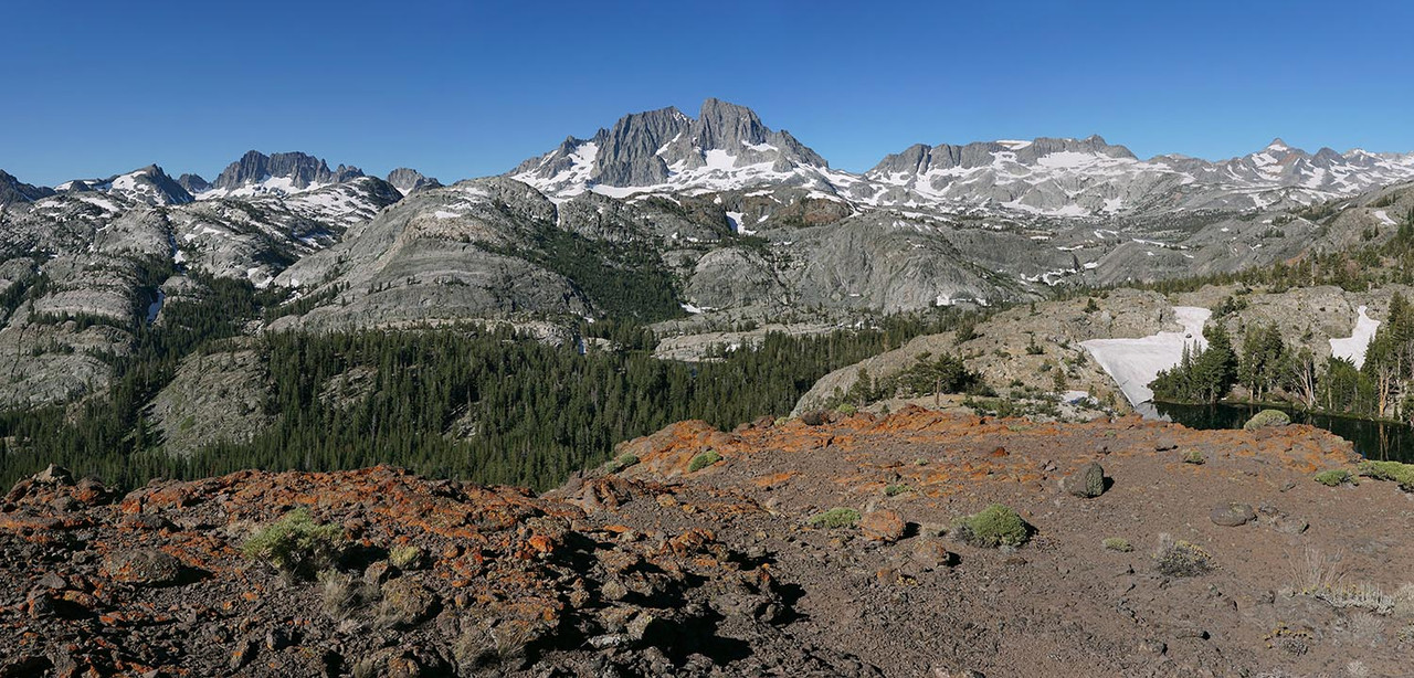
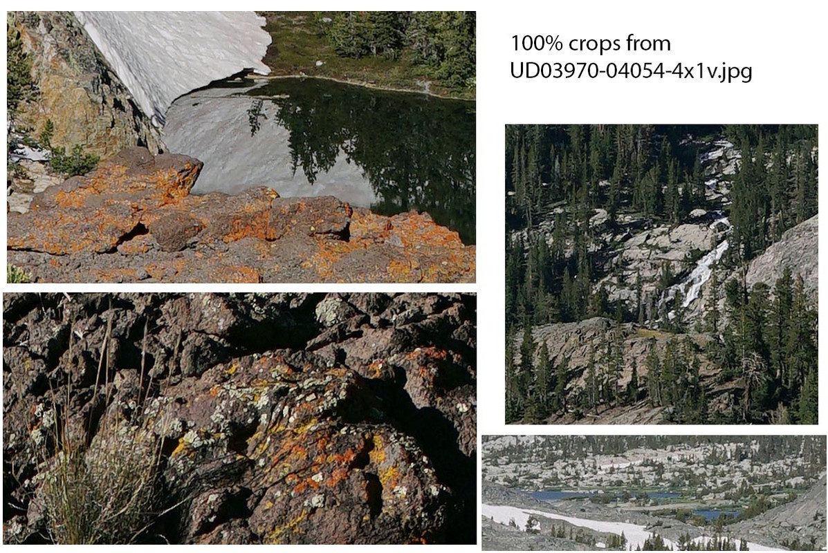
Another strong image now processed from San Joaquin Ridge. A 12500x6000 pixel 4 column 1 row 85 shot focus stack stitch blend. Below the above downsized for web image are below, four 100% pixels crop showing true detail. Crop lower left is from frame lower edge, lower right is 1000 Island Lake, upper right Garnet Creek, and upper left Summit Lake. Some of the largest Badger Lake is also visible. Also at skyline, Volcanic Ridge, Minarets, Ritter, Banner, Davis, Rodgers Peaks.