ISO Humphry's Basin info
-
d_silva1

- Topix Acquainted
- Posts: 32
- Joined: Sat Sep 10, 2011 11:50 am
- Experience: N/A
ISO Humphry's Basin info
My wife and I are planning to spend 5 - 6 days exploring Humphrey's Basin. any tips on good camp sites, place(s) to set up a base camp? Thanks.
-
balzaccom
- Topix Addict
- Posts: 2970
- Joined: Wed Dec 17, 2008 9:22 pm
- Experience: N/A
Re: ISO Humphry's Basin info
There definitely other threads on this. Do a quick search.
Much of Humphreys Basin, including most of the lakes, are well above tree line. They are often quite barren and desolate--e.g. Desolation Lake and its neighbors. We camped by Upper Golden Trout Lake, and day-hiked from there to most of the rest of the basin. There were a few trees there. Also, some very large High Sierra hares....
Much of Humphreys Basin, including most of the lakes, are well above tree line. They are often quite barren and desolate--e.g. Desolation Lake and its neighbors. We camped by Upper Golden Trout Lake, and day-hiked from there to most of the rest of the basin. There were a few trees there. Also, some very large High Sierra hares....
Check our our website: http://www.backpackthesierra.com/
Or just read a good mystery novel set in the Sierra; https://www.amazon.com/Danger-Falling-R ... 0984884963
Or just read a good mystery novel set in the Sierra; https://www.amazon.com/Danger-Falling-R ... 0984884963
-
LMBSGV

- Topix Fanatic
- Posts: 1015
- Joined: Sat Oct 27, 2007 8:42 pm
- Experience: Level 4 Explorer
- Location: San Geronimo, CA
- Contact:
Re: ISO Humphry's Basin info
As balzaccom said, most of Humphreys Basin is above treeline. Also, most of the basin is off-trail, though cross-country travel is relatively easy. It’s nearly all class 1 walking and Mt. Humphreys looming to the east means one can’t get lost.
In terms of places to base-camp, it depends on whether you want trees around or not. As balzaccom mentioned Upper Golden Trout Lake has a great campsite on the other side of the creek with some trees. There’s also Muriel Lake, which tends to have more people due to it being on a level use trail from Piute Pass. For treeless camping there’s Tomahawk Lake, Mesa Lake, and Upper and Lower Desolation lakes. There’s a trail to the Desolation lakes. Mesa has a nice sand beach on the west end. Also, some of the unnamed small lakes and tarns scattered around the basin also have campsites. One thing I’ve found is that once you get away from the main trail, the number of people one sees significantly decreases, so if you want solitude, stay off-trail.
In terms of places to base-camp, it depends on whether you want trees around or not. As balzaccom mentioned Upper Golden Trout Lake has a great campsite on the other side of the creek with some trees. There’s also Muriel Lake, which tends to have more people due to it being on a level use trail from Piute Pass. For treeless camping there’s Tomahawk Lake, Mesa Lake, and Upper and Lower Desolation lakes. There’s a trail to the Desolation lakes. Mesa has a nice sand beach on the west end. Also, some of the unnamed small lakes and tarns scattered around the basin also have campsites. One thing I’ve found is that once you get away from the main trail, the number of people one sees significantly decreases, so if you want solitude, stay off-trail.
I don’t need a goal destination. I need a destination that meets my goals.
http://laurencebrauer.com
http://laurencebrauer.com
-
davidsheridan
- Topix Regular
- Posts: 221
- Joined: Thu Jul 10, 2014 2:56 pm
- Experience: Level 3 Backpacker
Re: ISO Humphry's Basin info
I liked base camping at Mesa Lake. There is a small beach on one side, views of glacial divide are incredible. Good fishing.
Dayhike to Carol Col and Tomohawk Lake was an excellent day hike from Mesa.
I did not like Muriel as much because of talus around shoreline, wheras Mesa was easy access shoreline.
Dayhike to Carol Col and Tomohawk Lake was an excellent day hike from Mesa.
I did not like Muriel as much because of talus around shoreline, wheras Mesa was easy access shoreline.
-
SSSdave
- Topix Addict
- Posts: 3524
- Joined: Thu Nov 17, 2005 11:18 pm
- Experience: N/A
- Location: Silicon Valley
- Contact:
Re: ISO Humphry's Basin info
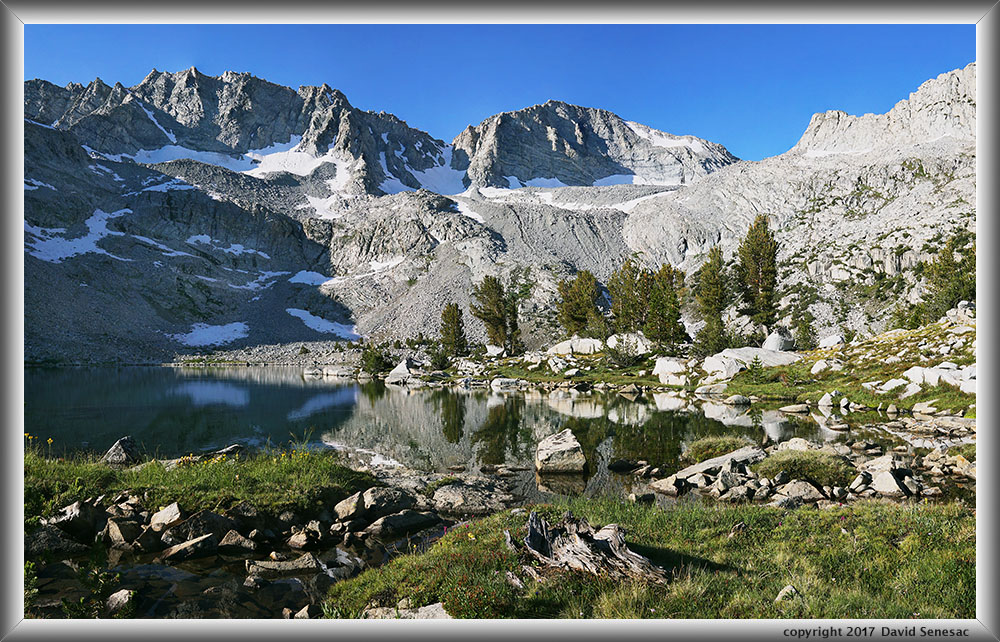
The majority of visitors camp at either Muriel Lake or the 2 Golden Trout Lakes. Most of the other lakes have few trees thus mid day shade to hide from the intense sun is limited. For those spending most of their days on trail or route, making camp late after sun altitude is low, that won't matter. However for base campers like this person, locating areas with whitebark pine trees is very important. Use the below caltopo map in NAIP mode with Contours to understand where trees exist.
https://caltopo.com/map.html#ll=37.2483 ... &a=c%2Cmba
The one basin, well away from trails with much solitude, with an abundance of shading trees, lots of lakes and streams, good alpine scenery with rugged peaks, and decent fishing, is the below Packsaddle Lake Basin.

https://caltopo.com/map.html#ll=37.2483 ... &a=c%2Cmba
The one basin, well away from trails with much solitude, with an abundance of shading trees, lots of lakes and streams, good alpine scenery with rugged peaks, and decent fishing, is the below Packsaddle Lake Basin.
Who is online
Users browsing this forum: No registered users and 111 guests