Topics covering photography and videography of the flora, fauna and landscape of the Sierra Nevada mountains. Show off your talent. Post your photos and videos here!
Yep, that is the spot. Nice "aerial view" . I recall in 2013, the beginning of the section right after the ravine where you see a tiny sliver of light touch the trail had eroded away, and trail crews were busy putting in a large steel girder to stabilize the section to later build up a new trail surface. Things were really narrow that day
mountaineer wrote: ↑Sat Nov 17, 2018 9:04 am
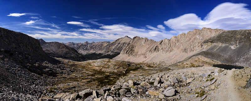
Nice shot! Can you pinpoint the location? I am familiar with a Forester Lake SE of Mineral King and this doesn't look like that terrain.
smack on the JMT still in Kings Canyon NP taken from the switchback the reaches the top of a ridge that leads you up to the final stretch of the pass
location was at the tip of the switchback that points north on this map - 12350 feet or so
This is looking up at the location from far below at about 11,000 feet on the JMT. The trail crests on that submarine turret like outcropping and then heads up the right and away from this view
mountaineer wrote: ↑Sat Nov 17, 2018 11:40 am
Thank you! On my list of "must visit" places now.
My plan was to go over Junction Pass, which I think has the better approach views compared to Forester. If you look to the right in the image, that ridge leading off the right side is the trail up to Junction. You're basically on the crest between Center Basin and the Forester Pass ramp. I just didn't have enough time to add half a day to my trip, as Junction on the other side is a slow sketchy descent and then you gotta get back up over Shepherd pass to get back on the west side of the Sierra crest.
When on Google sat view, zoom in on the ridge west of the JMT north of Forester - you can see the trail over Junction Pass clearly. This is the old pre-Forester Muir Trail. South side is eroded and nothing to look forward to, but the north has to be quite spectacular, plus you'll likely have the entire basin to yourself.