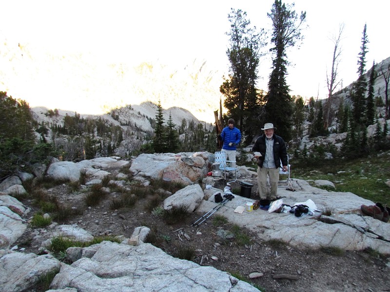
This trip was not about covering lots of ground but maximizing fishing time. None of this too tired to fish bs. Hiking days were short and fishing days long. Mid way we began to wonder if we could be satiated with fishing but every morning was greeted with enthusiasm for the fishing adventure to come. Markskor and I were packed in 14 miles on horseback then began to fish our way past 25 lakes in about 30 miles of backpacking and day hiking over the next 2 weeks. There was no smoke but occasional rain, with one day of rain, snow, hail that kept us tent bound. Wildflowers were outstanding as was the fishing. 15 inch cutthroats and rainbows became "oh hum" with only 17 to 18"+ becoming a notable fish. The following post is a pictorial with brief comments which will have to do instead of full TR for now.
to be continued
mike
Sawtooth 7-16 to 7-30 Pictorial
-
oldranger

- Topix Addict
- Posts: 2861
- Joined: Fri Jan 19, 2007 9:18 pm
- Experience: N/A
- Location: Bend, Oregon
Sawtooth 7-16 to 7-30 Pictorial
You do not have the required permissions to view the files attached to this post.
Mike
Who can't do everything he used to and what he can do takes a hell of a lot longer!
Who can't do everything he used to and what he can do takes a hell of a lot longer!
-
rlown

- Topix Docent
- Posts: 8225
- Joined: Thu Oct 25, 2007 5:00 pm
- Experience: Level 4 Explorer
- Location: Wilton, CA
Re: Sawtooth 7-16 to 7-30 Pictorial
I'm looking forward to the raft pics.. Nice report so far..
-
oldranger
- Topix Addict
- Posts: 2861
- Joined: Fri Jan 19, 2007 9:18 pm
- Experience: N/A
- Location: Bend, Oregon
Re: Sawtooth 7-16 to 7-30 Pictorial continued
Russ-no raft pics but a painting may be forthcoming from Mark.
Given my internet research we expected to catch cutthroats, rainbows, cutbows, brookies, goldens and greyling. the only fish we did not actually catch was a golden. By the time we caught grayling the battery in my camera died and my extras missed getting loaded in my pack so here is a pic off the internet. All the ones we caught were 10 inches or less. tthu, thhu, thats all Folks!
Mike
You do not have the required permissions to view the files attached to this post.
Mike
Who can't do everything he used to and what he can do takes a hell of a lot longer!
Who can't do everything he used to and what he can do takes a hell of a lot longer!
-
rlown
- Topix Docent
- Posts: 8225
- Joined: Thu Oct 25, 2007 5:00 pm
- Experience: Level 4 Explorer
- Location: Wilton, CA
Re: Sawtooth 7-16 to 7-30 Pictorial
1 battery? no second camera? two of you there.. umm. I love Mark's art but, c'mon.
Still a nice report and a year ahead of the usual report out. Thanks!
Still a nice report and a year ahead of the usual report out. Thanks!
-
maverick

- Forums Moderator

- Posts: 11841
- Joined: Thu Apr 06, 2006 5:54 pm
- Experience: Level 4 Explorer
Re: Sawtooth 7-16 to 7-30 Pictorial
Wow, surprised you got this up so quickly Mike, than you, beautiful. Really enjoyed the black bear and fish shots.
Did you guys visit Solitude Lake by any chance?
Did you guys visit Solitude Lake by any chance?
Professional Sierra Landscape Photographer
I don't give out specific route information, my belief is that it takes away from the whole adventure spirit of a trip, if you need every inch planned out, you'll have to get that from someone else.
Have a safer backcountry experience by using the HST ReConn Form 2.0, named after Larry Conn, a HST member: http://reconn.org
-
TehipiteTom

- Founding Member
- Posts: 953
- Joined: Thu Aug 24, 2006 8:42 am
- Experience: Level 4 Explorer
Re: Sawtooth 7-16 to 7-30 Pictorial
Looks like a great trip--thanks for the report & photos!
I think the mystery blue flower is Veronica cusickii (Cusick's Speedwell).
I think the mystery blue flower is Veronica cusickii (Cusick's Speedwell).
-
freestone

- Topix Expert
- Posts: 963
- Joined: Fri Nov 11, 2005 9:42 pm
- Experience: Level 3 Backpacker
- Location: Santa Barbara
- Contact:
Re: Sawtooth 7-16 to 7-30 Pictorial
....and no pictures of your new tent? Beautiful fish though! Thanks for posting.
Short cuts make long delays. JRR Tolkien
-
Eiprahs

- Topix Regular
- Posts: 112
- Joined: Sun Mar 18, 2012 7:12 pm
- Experience: Level 1 Hiker
- Location: Mount Angel, Oregon
- Contact:
Re: Sawtooth 7-16 to 7-30 Pictorial
Glad to hear you caught some good ones and had a great trip.
I like your choice of camp sites, too.
I like your choice of camp sites, too.
Dave
-
oldranger
- Topix Addict
- Posts: 2861
- Joined: Fri Jan 19, 2007 9:18 pm
- Experience: N/A
- Location: Bend, Oregon
Re: Sawtooth 7-16 to 7-30 Pictorial
Freestone,
here is the tent. In background is the easy side of the talus slog. The pic is taken from the same place that Eprah's pic was taken but in the opposite direction.
Dave thanks for the info you provided. We found the point of departure for the cross country portion of the hike to Flytrip from your description but mark and I had to laugh at your gps coordinates since neither of us carry a gps. Also you neglected to note that the departure point was at the second ford of the creek below the lakes but we figured that out pretty easily. Which lake is "P" lake, by the way?
Mike
You do not have the required permissions to view the files attached to this post.
Mike
Who can't do everything he used to and what he can do takes a hell of a lot longer!
Who can't do everything he used to and what he can do takes a hell of a lot longer!
-
Eiprahs
- Topix Regular
- Posts: 112
- Joined: Sun Mar 18, 2012 7:12 pm
- Experience: Level 1 Hiker
- Location: Mount Angel, Oregon
- Contact:
Re: Sawtooth 7-16 to 7-30 Pictorial
Mike. The true identity of P Lake is kinda a mystery to me. The references to it that I've seen are all unofficial user/trip report type documents. That said, the consensus of these is that P Lake drains into Heart Lake, so P Lake would be Lake 8646 and Heart Lake would be Lake 8562 on the following map:
http://www.mappingsupport.com/p/gmap4.p ... &z=16&t=t4
Ironically, two close by lakes have shapes that look like a letter "P", Lake 8546 and the lake immediately to its north, but I've never seen anything suggesting either is named P Lake.
The Margaret Fuller mentions both Heart Lake and P lake in her Flytrip Basin trail description, but does not identify them on her map. The minimalist directions she gives to XC to them suggest they are Lakes 8562 and 8646. The larger lake that looks like a "P", lake 8546 on the map, and the lakes due south of it, reportedly contain fish. In the report with the most detailed info on these lakes, the party camped at the southern-most lake.
I hoped to see all these other lakes on our next trip, but right now neither Susan nor Chris want to return to Flytrip Basin. I may be checking out the White Clouds.
Photo of P Lake from its outlet:
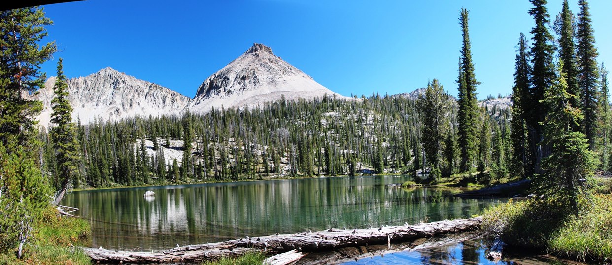 [/url]pano9
To change topics, did you and Mark fish Camp, Heart, and P Lakes, and if you did what did you catch?
http://www.mappingsupport.com/p/gmap4.p ... &z=16&t=t4
Ironically, two close by lakes have shapes that look like a letter "P", Lake 8546 and the lake immediately to its north, but I've never seen anything suggesting either is named P Lake.
The Margaret Fuller mentions both Heart Lake and P lake in her Flytrip Basin trail description, but does not identify them on her map. The minimalist directions she gives to XC to them suggest they are Lakes 8562 and 8646. The larger lake that looks like a "P", lake 8546 on the map, and the lakes due south of it, reportedly contain fish. In the report with the most detailed info on these lakes, the party camped at the southern-most lake.
I hoped to see all these other lakes on our next trip, but right now neither Susan nor Chris want to return to Flytrip Basin. I may be checking out the White Clouds.
Photo of P Lake from its outlet:
[/url]pano9 To change topics, did you and Mark fish Camp, Heart, and P Lakes, and if you did what did you catch?
Dave
Who is online
Users browsing this forum: No registered users and 127 guests