Wind Rivers V: North Fork of the Little Wind River 8/3-8/10 2014
This trip was for my husband – a mellow fishing trip to an area we had been to before so we knew the trails were “paw friendly” for our 2-year old border collie. We spent the first day he arrived in town visiting with friends and getting our gear sorted. The weather was perfect while we were in town; rain was forecast for the start of our trip. Isn’t that always the case! The plan was a leisurely nine days from St. Lawrence trailhead to Wilson Creek Lakes, Lake Heebecheeche, Lake Solitude, Wykee Lake with a day hike to Lake Solitude and return via Raft Lake and Twin Lakes trails. As usual, I had an agenda of plenty of nooks and crannies to check out and photos to take while my husband fished. This was another trip that did not turn out quite as planned.
Day 1- 8/3. St. Lawrence Guard Station to The Meadows. We sped past the poorly marked St. Lawrence Road, turning down another dirt road with a post missing a sign. After consulting the GPS we turned around and backtracked to find a small sign that marked the paved St. Lawrence Road which gave way to a dirt road. Like most roads that access high elevation trailheads on the east side, the road became narrow and rocky as it started switch-backing up the 16-degree dip slope of sedimentary rock. We topped out on a narrow road with a steep drop-off to the North Fork of the Little Wind River on our left and another steep drop to the right, with cows covering the one lane road. Thankfully nobody came from the other direction. We progressed about 2 mph, slowly pushing the cows back. After nearly half an hour we broke through the cows and drove out into a large meadow with surrounding trees that have been devastated by the bark beetle. In another mile we parked along several cars and trucks - I had never seen so many vehicles at this trailhead. As we walked the recently deadfall cleared 4wd road we found that there was a new smaller secondary parking lot about a half mile up. The road turned into a trail that gained 400 feet before it dropped to cross the South Fork of St Lawrence Creek. Our long haired border collie, Lupe, sat in the cool water. Worried that she would soak her dog food, we replaced it with our wading shoes. Slowly, one step at a time, we ambled up the trail for another 1200 feet of a very gentle elevation gain and broke out into another large meadow with a willow filled swamp. At 2PM we found a nice campsite in adjacent timber. Clouds were building. Not being acclimated, my husband did not have the energy to continue over the pass so we set up the tent. It spit rain a bit as I went back to the lower end of the meadow to check out a use-trail that supposedly drops to Twin Lakes. It started out horse-worthy but soon was strewn with fallen logs. Back in camp by late afternoon light rain began to fall. Several groups passed out tent to continue over the pass. One group decided to stop and camped down at the trail junction to the Twin Lakes use-trail. They were going to go down that trail and basically loop our route the opposite direction. One woman had an older border collie and was totally thrilled to see Lupe. We would see them later!
Day 2- 8/4. The Meadows to Wilson Creek. We awoke to cloudy skies, hoping to make it to Wilson Creek Lakes. Shortly after starting up the 600 feet gain to Entigo Peak Pass, light rain began and we put on rain jackets. We dropped to Entigo Creek and crossed where two large groups were camped – boy scouts to the south and another youth group north. Soon we ran into two fellows returning from Wilson Creek Lakes. They said that more large groups of youth were camped up there. I was astounded. This was more crowded than the JMT in the Sierra! We slogged on. The initial dribble hardly justified putting on rain pants but the rain very gradually became more intense and soon my pants were soaked. This was de-ja-vu for us. In 2007 we walked into Wilson Creek Lakes under almost the exact same conditions, except we also had thick fog, so were essentially lost nearly all the way. At exactly the same confusing spot we got lost previously, we did the same. It was now pouring down rain and I was soaked and chilled to the bone. The trail did not match the map; I scouted around with no avail and my mind was not working at full speed. A GPS does not help if the trail has been re-routed. We simply gave up, following the “trail” across the creek to a large established horse camp. According to the map, the trail does not cross the creek. We set up and hopped in the tent. Our poor dog was also soaked- nothing like the smell of a wet dog in the tent. It rained hard for an hour. When it let up, we heard commotion outside. The scouts had crossed the creek and were standing there, soaked and confused. From our camp the trail immediately re-crossed the river so I told the boys they had better keep on their wading shoes. Soon the leader came over to chat. Evidently they were aiming for the Lake Heebeecheeche Trail and had missed the trail junction more than a mile back. The troupe turned around and waded back through the creek. Rain continued. A brief bit of sunshine about 6PM allowed us a quick but dry dinner. Rain poured down all night. Are we having fun yet?
Day 3- 8/5. Wilson Creek to Enos Lake. We awoke to better weather and followed the trail which immediately crossed the creek about a hundred yards upstream from our previous crossing. We dried our feet, put on hiking shoes and soon passed another large established campsite just before coming to a lake that actually was a wide spot in Wilson Creek. The trail was distinct, and we simply followed it, though it did not match what was on the map. Skies remained overcast spilling gloom over the terrain. After about a mile we again waded across Wilson Creek at the lower end of another meadow. I must say that our feet stayed clean. Lupe entertained herself by chasing squirrels up trees as we slowly climbed the final 300-foot hill. At the end of another large meadow we reached the Enos Lake outlet, which is incorrectly located on the map. A family was camped on the east side and a scout group was camped across the creek. We found a somewhat secluded campsite in timber back along the shoreline. After fishing Enos Lake with no luck we dropped to lower lakes where my husband caught three nice 12-14 inch fish and I caught two smaller fish in the stream. Back at camp rain threatened and black clouds built, eventually spitting rain which drove us into the tent. Near dinnertime it cleared and we cleaned our fish under beautiful storm lighting. It was another early-to-bed day. My husband had all his electronic gadgets and read a book on his I-phone. I was a bit bored. Lupe was just happy to be camping; she loves being in the tent between the two of us.
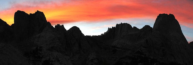
Day-4 8/6. Enos Lake to Tigee Lake plus day-hikes. The day started with a pink sunrise and threatening black clouds that hovered over Windy Ridge to the west, the direction we were headed. During breakfast, we could see a large group file by through the trees as they left. We packed up and crossed the creek. My husband with his long legs was able to hop across rocks at the outlet. I waded, which turned out to be quite difficult due to slippery rocks on the streambed. The trail continued to the inlet area of Tigee Lake and disappeared (the trail is not located where it is on the map). We found some game trails to Elk Lake where we had planned on camping. The lake was surrounded by steep hillsides and rocks: there was not a single spot to set up a tent! Reluctantly we backtracked to Tigee Lake and chose to camp out on a peninsula where it would be windy since the mosquitoes and black flies were thick in the wind-protected sites. Rain threatened so we quickly set up and again dove into the tent. After this initial storm, my husband threw a line in the lake and immediately pulled out a 16-inch Rainbow. As he continued to fish, I packed up for a day-hike to the drainage south of Tigee Lake and including several lakes under the north cliffs of Saddle Mountain and Wolverine Peak. In 2007 we had traversed above this drainage climbing over the shoulder of Saddle Mountain to drop to Lake Heebecheeche. This time I wanted to explore the lakes. The setting was spectacular unfortunately I was too late for early morning light so photos were not the best. Travel was difficult as I had to avoid thick willows, krumholtz and small cliffs. Luckily there were off-and-on game trails. I found a few cairns, but none that marked a real use-trail. I stopped above the upper lake (Lake 10675), not willing to thrash through the thick brush to reach the shore. Clouds were again building and I was worried about getting caught. It spit rain. When I reached the outlet from Tigee Lake, large fish were cruising along the shoreline but I did not bring my fishing rod. The weather was deteriorating quickly and just as I reached camp, I dove into the tent as the sky let loose. The wind howled; I had to lean against the tent poles to keep our tent upright. Lightning flashed, thunder roared, hail pounded us, heavy rain followed. Lupe hates thunder and lighting and became very agitated and barked as we tried to calm her. As suddenly as the storm arrived, it evaporated into thin air. I took a bath and then we cooked the fish my husband had caught. We were stuffed! And we celebrated; it was his 70th birthday. He did get to catch a huge fish, but the weather could have been better. Unfortunately I botched the rest of our dinner. We ate two coffee candies and warmed up with hot cocoa before heading into the tent. Finally we had a day of solitude. Nobody was up here but us.
Day-5 8/7. Tigee Lake to Wolf Creek. In 2007 we climbed over the shoulder of Saddle Mountain and dropped to Lake Heebeecheche. The route is not paw-friendly so we took the longer all-trail route. We retraced our steps back to the junction of the Wilson Creek Lakes Trail and the Heebeecheche Trail junction, which is not as shown on the map. “Not as shown on the map” became a reoccurring theme of backpacking on the Reservation. First we crossed Enos Creek where the family was also packing up. As we dropped to Wilson Creek a group across the creek happily yelled “Lupe”! It was the group we had met the first day. Lupe bound across the creek to meet them where she received many scratches behind her ears. They had a bag of their food stolen by a bear and in the excitement of hearing this story I forgot to ask them about the condition of the Twin Lakes and Raft Lake trails. The bear encounter was at the small lake we had planned to camp. When we arrived at the lake, we decided to continue to Wolf Creek. We had a bear canister for our food but had no desire to deal with a bear. The continuing trail was in very good condition. We had several swift creeks to cross and worried that Lupe would be washed downstream so we took packs across and then both of us helped her across. We reached Wolf Creek mid-day but it was already several miles past our planned camp, so I could not convince my husband to continue. We set up above Wolf Creek, downhill from the trail. An hour into our lazy afternoon, a large bear ambled up the hill about 100 yards from us. Lupe stood stone still. She has been trained not to chase animals, squirrels excluded, but we were not sure what she would do with a bear. We quickly put on her leash. We pounded pots and yelled. The bear continued slowly up the hill neither fearful of our noise, nor interested in coming closer. We will never know if this was the same bear that raided the camp of the other group. We had an uneventful dinner and enjoyed sunshine for the first time. Once in the tent, we noticed lots of black flies on the tent ceiling. Squishing them, they were full of blood. We wondered if we had been lax about fully closing the tent zippers. There were black flies at Tigee Lake, but not at Wolf Creek.
Day-6 8/8. Wolf Creek to Sonnicant Lake. It was a short distance to Lake Heebeecheeche where we had planned to camp and day-hike to the many surrounding lakes. The Heebeecheeche Trail does not go to Lake Heebecheeche, unlike it shows on the map. We missed the unmarked junction where a side-trail to Lake Heebeecheeche was overgrown (this we found when we returned). Soon I realized that we must have missed the trail. We decided that Sonnicant Lake would be a fine alternative base camp. We arrived before noon and found many established campsites and lingering snowfields. The air was still, skies were overcast and the black flies were thick. We set up and tried our luck at fishing. After having no luck, we headed downstream to the unnamed lake to the northeast, where we both were successful. Again my husband who was spin fishing caught the bigger fish far out in the lake and I caught more but smaller fish from the stream. Lupe had a ball, running up and down the shoreline, in and out of the water. It began to rain. Back at camp we hopped in the tent to be greeted by hundreds of black flies on the ceiling. We spent the afternoon squishing flies. The tent ceiling looked like a battlefield. I decided to inspect under Lupe’s thick fur, and the poor dog had red round bites all over her, the bites under her legs becoming infected where her pack rubbed. The flies had avoided us and gone for Lupe and the blood all over the ceiling of the tent was hers. We spent the next half hour pulling black flies off her and squishing them. Lupe would have to stay in the tent. We cooked dinner and fed her inside the tent, but she would not eat. She was acting sick; I suspect she was picking up on our worry. We decided that we would go back out a day early on the same trail we entered, skipping the loop via Raft Creek.
Day-7 8/9. Sonnicant Lake to Entigo Creek. We awoke to a spectacular sunrise. After about an hour of taking photos, we packed up and headed out. I now carried Lupe’s pack. Without this burden she bounded down the trail, as if nothing were wrong. Once a few miles back, the black flies subsided. We reached Entigo Creek mid-afternoon and camped at the large horse camp. This camp is complete with horseshoe pit and a “grave” quite artistically decorated with white bones and a horse skull. Evidently someone’s horse is buried there. I hiked down to the Raft Lake Trail on a trail that not only did not match what is on the map, but did not even appear on the contiguous map to the south. The trail was well used in places and very faint in places. At least I had located this elusive trail. Back at the tent, I hopped in just as intense rain started. After a typical 1-hour rain, it quit and we cooked dinner.
Day-8 8/10. Entigo Creek to St. Lawrence Trailhead. We retraced out inbound route over Entigo Creek Pass and down past The Meadows. The skies were cloudy but no rain fell. As we neared the trailhead it got downright hot and we reached the truck by noon. Lupe showed no sign of being ill although she was still full of bites. It was Sunday and we could not find a vet in town that was open. I called some of my friends who have horses and dogs. They said that infection was the only thing we had to worry about. Unlike fleas, black flies did not lay eggs in dog’s fur. Later I learned that black flies started to show up in the Wind Rivers about 10 years ago and their territory is confined to areas on the east side of the Divide, primarily on the Wind River Indian Reservation.
The next day the weather was perfect. We played tourist and drove to Washakie Reservoir to try fishing while Lupe ran up and down the sandy beaches. Then we took in sunset up Sinks Canyon, where the Middle Fork of the Popo Agie dives underground and resurfaces quarter mile downstream at a large pool full of humongous trout (fishing not allowed). My husband packed up to go home and I packed up for my next three trips on the northwest side of the Wind Rivers.
[rimg]http://i249.photobucket.com/albums/gg23 ... ited-1.jpg[/rimg]
Starting on our fishing trip
More photos to follow
[rimg]http://i249.photobucket.com/albums/gg23 ... ited-1.jpg[/rimg]
The Meadows - a glimpse of where we were headed
Wind Rivers V- North Fork Little Wind River
-
Wandering Daisy

- Topix Docent
- Posts: 6689
- Joined: Sun Jan 24, 2010 8:19 pm
- Experience: N/A
- Location: Fair Oaks CA (Sacramento area)
- Contact:
![[rimg]http://i249.photobucket.com/albums/gg23 ... ited-1.jpg[/rimg]](http://s249.photobucket.com/user/npallister/media/2014%20Wind%20Rivers/IMG_9098_edited-1.jpg.html)
![[rimg]http://i249.photobucket.com/albums/gg23 ... ited-1.jpg[/rimg]](http://s249.photobucket.com/user/npallister/media/2014%20Wind%20Rivers/IMG_9207_edited-1.jpg.html)
-
Wandering Daisy
- Topix Docent
- Posts: 6689
- Joined: Sun Jan 24, 2010 8:19 pm
- Experience: N/A
- Location: Fair Oaks CA (Sacramento area)
- Contact:
Re: Wind Rivers V- North Fork Little Wind River
[rimg]http://i249.photobucket.com/albums/gg23 ... ited-1.jpg[/rimg]
[rimg]http://i249.photobucket.com/albums/gg23 ... ited-1.jpg[/rimg]
[rimg]http://i249.photobucket.com/albums/gg23 ... ited-1.jpg[/rimg]
[rimg]http://i249.photobucket.com/albums/gg23 ... ited-2.jpg[/rimg]
[rimg]http://i249.photobucket.com/albums/gg23 ... ited-1.jpg[/rimg]
[rimg]http://i249.photobucket.com/albums/gg23 ... ited-2.jpg[/rimg]
[rimg]http://i249.photobucket.com/albums/gg23 ... dited3.jpg[/rimg]
[rimg]http://i249.photobucket.com/albums/gg23 ... ited-1.jpg[/rimg]
[rimg]http://i249.photobucket.com/albums/gg23 ... ited-1.jpg[/rimg]
[rimg]http://i249.photobucket.com/albums/gg23 ... ited-1.jpg[/rimg]
[rimg]http://i249.photobucket.com/albums/gg23 ... ited-1.jpg[/rimg]
[rimg]http://i249.photobucket.com/albums/gg23 ... ited-1.jpg[/rimg]
[rimg]http://i249.photobucket.com/albums/gg23 ... ited-1.jpg[/rimg]
[rimg]http://i249.photobucket.com/albums/gg23 ... ited-2.jpg[/rimg]
[rimg]http://i249.photobucket.com/albums/gg23 ... ited-1.jpg[/rimg]
[rimg]http://i249.photobucket.com/albums/gg23 ... ited-1.jpg[/rimg]
![[rimg]http://i249.photobucket.com/albums/gg23 ... ited-1.jpg[/rimg]](http://s249.photobucket.com/user/npallister/media/2014%20Wind%20Rivers/IMG_9109_edited-1.jpg.html)
[rimg]http://i249.photobucket.com/albums/gg23 ... ited-1.jpg[/rimg]
![[rimg]http://i249.photobucket.com/albums/gg23 ... ited-1.jpg[/rimg]](http://s249.photobucket.com/user/npallister/media/2014%20Wind%20Rivers/IMG_9115_edited-1.jpg.html)
[rimg]http://i249.photobucket.com/albums/gg23 ... ited-1.jpg[/rimg]
![[rimg]http://i249.photobucket.com/albums/gg23 ... ited-1.jpg[/rimg]](http://s249.photobucket.com/user/npallister/media/2014%20Wind%20Rivers/IMG_9118_edited-1.jpg.html)
[rimg]http://i249.photobucket.com/albums/gg23 ... ited-2.jpg[/rimg]
![[rimg]http://i249.photobucket.com/albums/gg23 ... ited-2.jpg[/rimg]](http://s249.photobucket.com/user/npallister/media/2014%20Wind%20Rivers/IMG_9120_edited-2.jpg.html)
[rimg]http://i249.photobucket.com/albums/gg23 ... ited-1.jpg[/rimg]
![[rimg]http://i249.photobucket.com/albums/gg23 ... ited-1.jpg[/rimg]](http://s249.photobucket.com/user/npallister/media/2014%20Wind%20Rivers/IMG_9122_ALT_edited-1.jpg.html)
[rimg]http://i249.photobucket.com/albums/gg23 ... ited-2.jpg[/rimg]
![[rimg]http://i249.photobucket.com/albums/gg23 ... ited-2.jpg[/rimg]](http://s249.photobucket.com/user/npallister/media/2014%20Wind%20Rivers/IMG_9131_edited-2.jpg.html)
[rimg]http://i249.photobucket.com/albums/gg23 ... dited3.jpg[/rimg]
![[rimg]http://i249.photobucket.com/albums/gg23 ... dited3.jpg[/rimg]](http://s249.photobucket.com/user/npallister/media/2014%20Wind%20Rivers/IMG_9132_edited3.jpg.html)
[rimg]http://i249.photobucket.com/albums/gg23 ... ited-1.jpg[/rimg]
![[rimg]http://i249.photobucket.com/albums/gg23 ... ited-1.jpg[/rimg]](http://s249.photobucket.com/user/npallister/media/2014%20Wind%20Rivers/IMG_9146_edited-1.jpg.html)
[rimg]http://i249.photobucket.com/albums/gg23 ... ited-1.jpg[/rimg]
![[rimg]http://i249.photobucket.com/albums/gg23 ... ited-1.jpg[/rimg]](http://s249.photobucket.com/user/npallister/media/2014%20Wind%20Rivers/IMG_9148_edited-1.jpg.html)
[rimg]http://i249.photobucket.com/albums/gg23 ... ited-1.jpg[/rimg]
![[rimg]http://i249.photobucket.com/albums/gg23 ... ited-1.jpg[/rimg]](http://s249.photobucket.com/user/npallister/media/2014%20Wind%20Rivers/IMG_9152_edited-1.jpg.html)
[rimg]http://i249.photobucket.com/albums/gg23 ... ited-1.jpg[/rimg]
![[rimg]http://i249.photobucket.com/albums/gg23 ... ited-1.jpg[/rimg]](http://s249.photobucket.com/user/npallister/media/2014%20Wind%20Rivers/IMG_9217-6_merge4_edited-1.jpg.html)
[rimg]http://i249.photobucket.com/albums/gg23 ... ited-1.jpg[/rimg]
![[rimg]http://i249.photobucket.com/albums/gg23 ... ited-1.jpg[/rimg]](http://s249.photobucket.com/user/npallister/media/2014%20Wind%20Rivers/IMG_9175_edited-1.jpg.html)
[rimg]http://i249.photobucket.com/albums/gg23 ... ited-1.jpg[/rimg]
![[rimg]http://i249.photobucket.com/albums/gg23 ... ited-1.jpg[/rimg]](http://s249.photobucket.com/user/npallister/media/2014%20Wind%20Rivers/IMG_9184-6_merge_edited-1.jpg.html)
[rimg]http://i249.photobucket.com/albums/gg23 ... ited-2.jpg[/rimg]
![[rimg]http://i249.photobucket.com/albums/gg23 ... ited-2.jpg[/rimg]](http://s249.photobucket.com/user/npallister/media/2014%20Wind%20Rivers/9132-3_merge_edited-2.jpg.html)
[rimg]http://i249.photobucket.com/albums/gg23 ... ited-1.jpg[/rimg]
[rimg]http://i249.photobucket.com/albums/gg23 ... ited-1.jpg[/rimg]
![[rimg]http://i249.photobucket.com/albums/gg23 ... ited-1.jpg[/rimg]](http://s249.photobucket.com/user/npallister/media/2014%20Wind%20Rivers/IMG_9196_edited-1.jpg.html)
-
Wandering Daisy
- Topix Docent
- Posts: 6689
- Joined: Sun Jan 24, 2010 8:19 pm
- Experience: N/A
- Location: Fair Oaks CA (Sacramento area)
- Contact:
Re: Wind Rivers V- North Fork Little Wind River
Sorry about no titles - photobucket has been acting up this morning.
First three- Enos Lake
Elk Lake
Camp at Tigee Lake
Next two - day hike to cirque below Saddle Mountain
Successful fishing at Tigee Lake
Next two - Lupe
Next two - Sonnicant Lake
Pond near Sonnicant Lake
Profile of cirque below Saddle Mountain
The Meadows (sorry - a repeat)
Camp on Entigo Creek (the one with the horse grave!)
-
Eiprahs

- Topix Regular
- Posts: 112
- Joined: Sun Mar 18, 2012 7:12 pm
- Experience: Level 1 Hiker
- Location: Mount Angel, Oregon
- Contact:
Re: Wind Rivers V- North Fork Little Wind River
WD, you always have such amazing adventures! After reading your trip account, I feel deprived for lack of biting insects, wind, hail, lightning, trout dinners, glorious sunsets!
Thanks for sharing.
To the Winds:
Thanks for sharing.
To the Winds:
Dave
-
ofuros

- Topix Acquainted
- Posts: 82
- Joined: Tue May 13, 2014 1:06 am
- Experience: N/A
- Location: Australia
Re: Wind Rivers V- North Fork Little Wind River
Chasing trout & hiking the wilds...my favourite pastimes.
Great post.
Great post.
Out 'n about....looking for trout.
https://ofuros.exposure.co/" onclick="window.open(this.href);return false;
https://ofuros.exposure.co/" onclick="window.open(this.href);return false;
Who is online
Users browsing this forum: No registered users and 122 guests