Questions and reports related to Sierra Nevada current and forecast conditions, as well as general precautions and safety information. Trail conditions, fire/smoke reports, mosquito reports, weather and snow conditions, stream crossing information, and more.
Lobo wrote:Eric - here's a few photos. Most of the snow you see is on a North facing slope. The first is the view from the high trail, looking toward's Shadow Lake. The second one is by the outlet of Thousand Island lake, and almost everything is covered. The third one is a pano around Shadow creek. I should also note that my friend's Corgi, with 4" long legs, did the whole hike without any problems, other than having to be carried over some creek crossings.
Dave - The Postpile road was closed to vehicles, but open to bicyclists and pedestrians, so we had an extra 3-4 mile walk from the Mammoth ski resort. They plowed it on Sunday though, so it's a pretty easy walk. I'm not sure when they'll be opening it for the shuttle. The nice thing is that it's keeping the crowds out.
Thanks so much for this! We have permits for Thousand Island Lake area and were digging so much to figure out the best way to Agnew Meadows. I have 4 days off and was willing to hike to the area from an open, safe trail. But all I came up with was closures and danger, and the ranger stations have been hard to get a hold of.
To the rest of the group - I was thinking a couple days exploring Toulumne Meadows through Tioga Pass (I have never been through this area) until my Thousand Island Lakes permit comes into effect for Monday. Is it safe to drive up to TIoga, explore, then head to Mammoth and do the intended loop? I think that would be a splendid way to spend my long weekend.
Had to get my July skiing in so we hit Mammoth, here is a photo from the top. There is/was a fire somewhere so the view wasn't the best but you get the idea...Lots of Snoooow
You do not have the required permissions to view the files attached to this post.
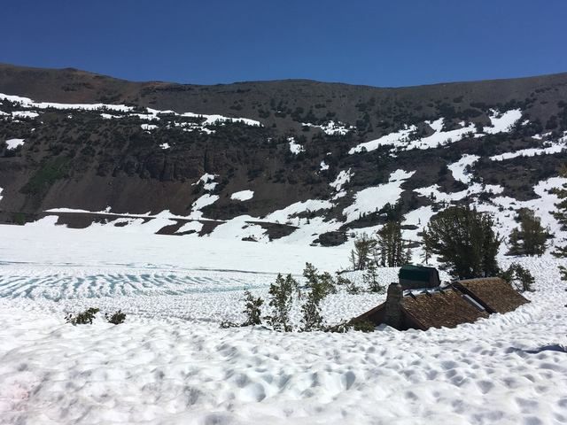
Saddlebag Lake and store taken July 2, 2017. Copied from their FB page.
"On this proud and beautiful mountain we have lived hours of fraternal, warm and exalting nobility. Here for a few days we have ceased to be slaves and have really been men. It is hard to return to servitude."
-- Lionel Terray
Anyone have info on Sabrina Basin? I have a permit from the Lake Sabrina trailhead this weekend (7/8) and wanted to head to either Midnight/Moonlight/Hungry Packer Lake. Thanks in advance!
My original plan was to hike a loop from Middle Velma to either Clyde or Aloha, then over Dicks Pass to Dicks Lake as a three night trip. The large amount of snow led me to change the trip to a two-night trip at Middle Velma with a hike up Phipps Peak.
I had seen pictures of Middle Velma from two weeks ago showing it still iced-in. It's now completely iced-out. From Phipps I could see that Upper Velma was about 2/3 iced out, and what I could see of Dicks, Fontanillis, and Schmidell was still iced-in. The ford just before Middle Velma Lake was knee-high and running fast.
Conditions along the trail to Middle Velma are changing quickly as the snow at that elevation is melting. Generally, it was snow-hiking from Maggies Crest to where the trail drops onto the south side of the ridge leading to the Eagle Lake Trail junction, the western part of the trail segment between the Eagle Lake and Velma junctions, and westward from there. There was a lot of snow on the steep portion just east of Maggies saddle.
SAR has apparently been busy, as people hiking the Bayview Trail east from the Velma junction have been making a wrong turn where the trail climbs a switchback to the left. At this point there's a prominent track through the snow heading straight - the wrong way, down into the Azure and Cascade Falls drainage.
Swimming: Middle Velma was far too cold for me, having recently iced-out. On the way out, Granite Lake made for a pleasant swim.
Bugs: black flies were terrible in the evening as the breezes died down, mosquitoes were out in the morning before the breezes started.
I don't give out specific route information, my belief is that it takes away from the whole adventure spirit of a trip, if you need every inch planned out, you'll have to get that from someone else.
Have a safer backcountry experience by using the HST ReConn Form 2.0, named after Larry Conn, a HST member:http://reconn.org
Know of two HST members coming out today from that area, so you should have a conditions report in the next day or two.
Professional Sierra Landscape Photographer
I don't give out specific route information, my belief is that it takes away from the whole adventure spirit of a trip, if you need every inch planned out, you'll have to get that from someone else.
Have a safer backcountry experience by using the HST ReConn Form 2.0, named after Larry Conn, a HST member:http://reconn.org
Trails are clear through Cottonwood Pass to Soldier Lakes aside from a couple minor berms that melted out significantly over the three days.
Trail to the Army Passes from the junction with Rock Creek trail looked mostly snow free. Didn't meet anyone who had crossed the pass from Cottonwood Lakes (although met a couple who were going to try from the Soldier Lake side with microspikes).
Mitre Basin is pretty snow free. Minor snow patches up to Blue Sky Lake. Lake is still ~40% ice with lots of icebergs. Snow at lake edge most of the way around but the basin up to Crabtree Pass is ~30% snow.
Creeks in the basin are easily crossable with planning but the lake outlets are raging. The creek lower down towards the main trail is loud and white - didn't try the use trail down to Rock Creek trail. Lots of standing water...the mosquitos will be coming out in force soon.
Just got back from Sabrina basin. We stayed at Blue lake, then day hiked a bit above Dingleberry one day and up to a ridge above Lower Baboon lake yesterday.
George Creek is running high and fast to about knee deep for a 6' person. A subject for another post, but sitting for a bit after crossing on the way in, we watched several hikers cross. It was painful to watch as most were inexperienced crossing steep, swift runoff.
Spotty snow up to Blue Lake.
More snow on the traverse around to Dingleberry Lake, but avoidable if you climb up and around the steeper snow banks. The inlet stream to Dingleberry Lake is running high, but very manageable. Crossing is easiest about 30' above the trail crossing where it is mostly sandy. Just above knee deep, but all of the creeks are swelling at this time. The whole area from around 11K up is basically full snow coverage.
The hike up to Baboon Lakes is about 50% coverage once you get above Donkey lake. Donkey Lake was 50% ice.
Coverage gets more intense from there. It would not be prudent to go up to Baboon Lakes without crampons and ice axe. Since a goal of our trip was to work out with crampons and ice axe, it was perfect for us. We worked straight up a snow chute to an overlook at 11,200 looking down on Baboon Lakes.
Baboon Lakes 50% surface ice.
Everything up to about 10, 500 is patchy snow. Some large patches. Everything from there to about 10,800 is more cumbersome with quite a bit of large patchy snow. Everything from 11,000 up is basically full coverage. Really an awesome site to see when camped at one of the lower lakes.
Blue and Dingleberry Lakes have a lot of standing water around and you know what that means. Mosquitoes!
July 1st, the skeeters were a 1 on a 1 to 5 scale with an increase to 2.5 during the golden and blue hours of dawn and dusk. It got worse every day. Yesterday was a 3 in the morning and a raging 5 from the time we were back at camp until total darkness when they subsided a bit. And only a bit.
The place is beautiful right now if you come prepared for skeeters and have no plans to get up to the high lakes or come fully prepared for snow.
Last edited by maverick on Thu Jul 06, 2017 5:24 pm, edited 2 times in total.
Reason:subject matter
If you don't know where you're going, then any path will get you there.