
Days 14- 24 (north-to-south)
North Lake to Devils Postpile
Change of pace. Gramps is not a “light and fast” proponent; “lots of goodies and slow” is his preference. We now have binoculars, fishing gear, the Nook reader, a frying pan, extra gas, gourmet food and a 6-pound palace of a tent! I stuff the extra weight in my Golite Quest deciding to suffer the first few days rather than switch to my load carrier- the old Kelty external frame. As much as I would like to continue north-to-south, the first day going this direction is committing- no water so you have to make it to Deer Lakes. With Gramps arriving right from sea-level, we trading route purity for practicality and started at North Lake where the Piute Pass trail offers multiple “bail out” campsites and has many water sources if you cannot reach your intended destination.
Day 14 August 16 (3.3 miles, 3.5 hours, +1720 feet). More logistical problems in the morning! The ranger who wrote our permit told us there was a bear box at the Duck Lake trailhead. After trouble finding the trailhead, we then found a sign in the bear box that said “day use only”. We finally went into an inn nearby and the owners graciously stored our extra food supplies. Then we drove to the George Lake parking lot only to spend half an hour with the camp host figuring out where we could legally park overnight. Leaving Gramps car, we then drove to Bishop in my car, bought perishables and headed to North Lake, where, guess what – there were no parking spaces left! I dropped Gramps and our packs at the trailhead and drove down the road. Finally someone left an unmarked pull-out down the road from the backpacker’s parking lot. I walked the half mile back to the trailhead. It was 1:00 before we started. It was hot as we slowly trudged up the trail reaching Piute Lake at 4:30. Gramps fished as I hunted for the “perfect campsite”. This practice of mine really annoys him unless he has something to do like fish. He caught a little fish as I found the site and set up; he graciously gave me the fish for dinner. There were a few other people, but it did not seem crowded.
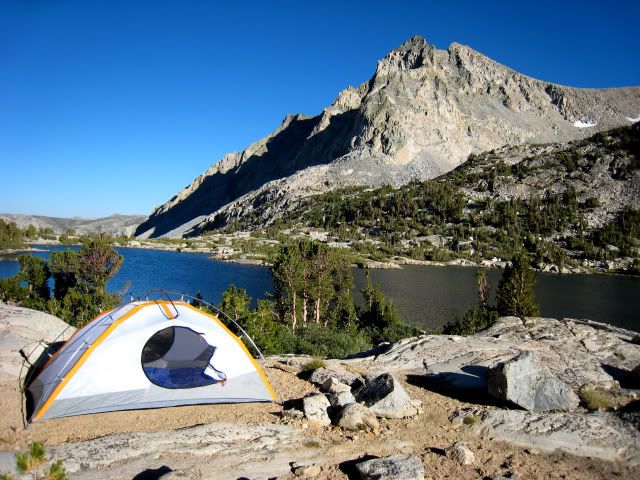
Camp at Piute Lake
Day 15 August 17 (7.0 miles, 7.7 hours, +1325 feet). We were up before the sun hit our site and left at 8:00 reaching Piute Pass by 9:00. We left the trail at the Desolation Lake junction and headed off-trail to Tomahawk Lake. The terrain is very flat with few landmarks. Gramps GPS did not agree with my idea of how to get there! I ignored GPS and we got there fine. This is our on-going battle – technology and gadgets vs. old fashioned map reading. I followed as we headed for Puppet Pass via GPS directions. We do have to compromise! The descent is tough – steep talus and it took us an hour. My knees took a beating. As we were going down we saw 2 day-hikers going up north of our steep descent. They seemed to be doing better going up ledges and slabs, but without big packs on their backs, it is hard to tell. Their route required topping out a lot higher on the ridge. Then it was an easy walk to a nice campsite on the north side of Paris Lake at 4PM. The wind was fierce but Gramps insisted on fishing. He caught a nice Golden Trout, cleaned it, set it down and a big wave washed it away! No fish for dinner tonight. In spite of the cold wind I took an icy bath; what a shock getting out of the water! The wind died down during the night and a few clouds moved in.

View from Puppet Pass

Camp at Paris Lake
Day 16 August 18 (3.6 miles, 4.1 hours, +980 feet). After the long previous day, we slept in and left at 9:00. I took a brief morning walk to Alsace Lake for a photo. As we left camp, I failed to look at my map and went down the gap north of Puppet Lake instead of the gap north of Alsace Lake. It worked out but was not the easiest way down. Footprints indicated other fools made the same mistake! We intersected the French Canyon trail at 10:15. Finding the trail to Merriam Lake was another battle between actual scouting and the GPS. The map shows a trail on the northeast side of the creek from Merriam Lake, but a big obvious trail starts on the southwest side. Every steep step of the trail Gramps let me know that he thought the ‘real” trail was on the other side. Clouds were building and it actually looked quite threatening. We passed two guys who had camped early in fear of rain. They asked my opinion; I said that rain is what I carry my rain jacket for. We went on to find a nice campsite at Merriam Lake. The weather improved a bit and we both took baths. Soon we saw the two fellows also coming on up to the lake. I am glad they did – it is beautiful and they would have missed out by hunkering down on an ugly lower campsite. Gramps caught four nice little fish that perfectly fit in our little frying pan.

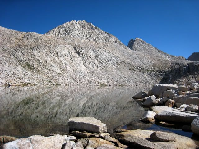
Marion Lake
Day 17 August 19 (3.8 miles, 6.75 hours, +1450 feet). Clouds built during the night but it cleared by morning. We left at 7:45 and reached LeSalle Lake over easy terrain by 9:30. We went around the west side then up grassy ramps, to a headwall which required a little rock scrambling. The altitude got to Gramps and we did not reach the pass until 11:30. The northwest side of the pass is tricky at top – cliffs and benches. There was considerable snow and I debated about using it. We easily descended on snow until it ended at huge talus blocks. We probably should have stayed on rock and headed for the dirt slope to the north. There was a surprising amount of snow we had to cross, even at the lower parts of the pass. Two day-hikers more quickly descended the pass in the distance; we did not get close enough to talk with them. We reached our campsite at the outlet of Ursa Lake by 2:30. We both jumped in the lake and then Gramps went fishing, first at Ursa Lake and then at Big Bear Lake. There were lots of fish but few biting. Persistently fishing, by 6:00 he trudged up the hill with four fish for the frying pan. That afternoon the zipper in my main insulating jacket broke. I stitched the lower part together with dental floss making it an anorak. I had to squirm in and out of it but thankfully the top part of the zipper still worked. The evening was clear and the moon nearly full as it rose and the sun set.

Leaving Marion Lake
LeSalle Lake below Feather Pass

Seven Gables

Sunset at Ursa Lake
Day 18 August 20 (4.8 miles, 6.0 hours, +910 feet). The sun finally hit our campsite as we left at 7:45. We met a couple with three dogs at Black Bear Lake. It was easy going up to White Bear Lake where there was a nice trail over the cliffs on the north side of the lake. Troubles began as we descended White Bear Pass. I really must have missed something on this pass. It was horrible. We headed for the “bushes” per Roper’s directions, but from there it was not an easy descent. Instead we ended up in nearly vertical vegetation and loose talus. Gramps was cursing Roper before we got down! We went around the north shores of Brown Bear and Teddy Bear Lakes. Although these are pretty lakes, going down White Bear Pass is a high price to pay! I have previously gone over Dancing Bear Pass and it is much nicer. We finally intersected the Italy Lake trail. Conditions really skew your impression of place. Last time we were here years ago, it was windy, cold, snowy and bleak. This time it was sunny and the walk around the lake was wonderful. What a beautiful blue body of water! For logistical reasons we wanted to get as far as possible so camped at Toe Lake. Toe Lake had less wind but no fish and is ugly. I explored the upper reaches of the inlet. The creek from Gabbot Pass was dry; a small bit of water was seeping from the talus below Bear Creek Spire. Travel around Italy Lake was much easier than expected- essentially there is a use-trail. White Bear Pass threw me for a loop, took much longer than expected and really trashed my feet and knees. We went to bed at 7:00 glad to be on our backs.

Leaving Big Bear Lake going towards Black Bear Lake

White Bear Lake

Italy Lake

Camp at Toe Lake
Day 19 August 21 (5.3 miles, 7.75 hours, +1050 feet). After a warm night, stratus clouds were building to the north as we left Toe Lake at 7:45. At 9:30 we reached Gabbot Pass and met a group of people with two dogs. The north side of the pass was very snowy and we were able to walk in their footprints most of the way descending the upper 400 feet. To drop to Upper Mills Creek Lake there are worn paths down two gullies- we chose the more used western gully- probably a mistake as it was miserable. We had been down this pass before, taking neither gully, but instead descending the more technical but pleasant slabs and rock benches to further west. My inclination to want to try something new each time I travel through an area caused us grief today. Oh, well. At least I now know which way NOT to descend this pass! Threatening weather hurried us along the lake shoreline. I regret not walking here more leisurely and taking more photos, but getting lower quickly was our priority. We reached beautiful campsites at Lower Mills Creek Lake at noon. I was torn about stopping here or continuing to Mills Creek. If we stayed we likely would not reach Laurel Lake the next day. We descended, carefully searching out for the use-trail. The first time I came up here, I missed the use-trail resulting in an epic bushwhack. We met two groups going up as we descended. At 3:30 we found a nice campsite at the confluence Mills Creek and the creek from the Second Recess. Dark stratus clouds transformed to fluffy cumulous clouds above us, however, the sky was black to the north where we later heard that it had rained heavily. Mosquitoes were bothersome as Gramps fished and I bathed and washed clothes. Gramps caught a frying pan full of sardine sized fish and for the first time we were at an elevation allowing campfires, so we cooked them on a fire. It was a nice break being down in trees with a campfire. The travel took longer than expected. We are now realizing that descending off-trial terrain with old knees slows us down more than going uphill. The night was cloudy and warm and the storm ended and we lucked out without a drop of rain.

Gabbot Pass

Lower Mills Creek Lake
Day 20 August 22 (5.3 miles, 5.75 hours, +1800 feet). I had a headache all night and felt ill all day. We left again at 7:45 quickly reaching Mono Creek where I waded and Gramps bushwhacked to a large log upstream. Wading was much easier. We slowly inched up the very steep Laurel Lake trail reaching the lake at 1:30 and found a nice campsite on the east side. Laurel Creek was very pretty with meadows full of flowers and lushly green. There was a breeze to keep mosquitoes down and the sun was warm. I filled the bear canister with water and let it warm, then washed my hair and clothes! This was a very domestic afternoon, as I then surveyed and organized all the food – we had plenty, almost too much so we could pig-out from now on! The lake was full of 6-inch fish and Gramps quickly caught a frying pan full. Laurel Lake is a shallow lake gradually filling up with silt, but more beautiful than I expected. Although the hike was short, I still did not feel well enough for a day-hike up to Grinnell Lake. It turned out to be an easy day- no off-trail travel and no difficult passes. Gramps was finally getting acclimated. The night was cold and frosty in the full moon.

Laurel Creek

Laurel Lake
Day 21 August 23 (3.2 miles, 6.5 hours, +1500 feet). What was supposed to be a short day turned out to be longer than we expected. Today was Gramps turn to lack energy and he was disagreeable all day. We had our share of spousal bickering. No matter how slow I went it was too fast. I lacked sympathy and was short tempered. Days like these make me long for solo travel. But, once in camp we reconciled and catching two nice big fish cheered up Gramps. We reached the pass south of Rosy Finch Lake by 10:00 and took a nice break at the lake, observing many fish. We then reached the second pass above Tully Lake at 12:30, having route-finding difficulties on the traverse. We hit it perfectly a few years back going the opposite direction and it irritated me that I missed it this time. We did hit the route perfectly descending and reached our campsite at Tully Lake by 2:30. The High Route officially goes via Izaak Walton Lake but we had done this two years earlier and I always wanted to camp at Tully Lake. I am glad we did, as Tully Lake is beautiful. The slowly changing sunset lighting at Tully Lake is perfect for photographs, in my opinion far superior to Izaac Walton Lake. I spent a few hours exploring the little ponds and meadows above the lake while Gramps fished. By 7:00 our little campsite was in the shadows and it was still warm when we hopped into the tent. When I got up at night, the moonlight on the white dikes embedded in the black rock glowed.

Rosy Finch Lake

Camp at Tully Lake

Tully Lake Fish
Day 22 August 24 (6.3 miles, 6.0 hours, +1600 feet). By early morning we had frost in spite of the warm earlier evening. Initially, it was pleasant to be on the McGee Pass trail descending next to the spectacular rocky canyon of Fish Creek. Then we hit Horse Haven, which should have been named Mosquito Haven. Things got worse. When we hit the PCT/JMT hordes of people and the dusty trail were not appealing. Today Gramps had is “mojo” back and was hoofing it like crazy! The day was hot and calm, conditions that I dislike so it way my day to have no energy. We arrived at Virginia Lake at noon, and although camping here is better, we continued to Purple Lake and found an over-used ugly established campsite at 2:00. We got drinking water from a surprisingly cold little creek. I washed the dust from my clothes and sat naked in the tent waiting for them to dry! Gramps sat in the shade and read. His “Nook” was getting low on power, a great disappointment to him! I walked around and photographed, meeting a group of Australian PCT hikers who had skipped to Oregon earlier because of snow and now were back doing the Sierra part of the PCT.

Virginia Lake

Purple Lake
Day 23 August 25 (5.5 miles, 6.0 hours, +2050 feet). We both slept well and again awoke to frost and very moist air. You could not have asked for a more horrible morning. A dog that camped nearby came over and peed all over our campsite! Ugh! I cooked eggs and sausage with potatoes – what a chore cooking small batches in our little frying pan, nearly burning the eggs and having my meal cold by the time I got to sit down to eat. The meal was tasty as long as you were not the cook! Clean-up was difficult. We did not get on the trial until 8:30 in spite of getting up at 6:00. We met a trail crew on the PCT. Once off the PCT on the Duck Pass Trail, my mood improved. From Duck Pass we left the trail and followed a use-trail north. The trail definitely DOES NOT match what is shown on the map. We found the notch and dropped to Deer Lakes, much more impressive than I had expected. We were again away from the crowds and felt more like we were back into the wilderness. We reached the northern Deer Lake at 2:00. I heard day-hikers but never saw them. Gramps went fishing and I joined him sitting on the rocks. Thump- a big fish splashed at our feet! It took a few hours, but finally Gramps landed the biggest fish of the trip. One fish was enough for dinner. We had a very pleasant afternoon, even as clouds built in the sky; it was another threatening day with no rain.

Duck Lake

Deer Lakes
Day 24 August 26 (8.1 miles, 4.0 hours, +720 feet). Today we walked out. A well-worn trail ascends the Mammoth Crest through sandy slopes dotted with gnarled trees. At the George Lake trail junction, we parted. Gramps descended to our car and retrieved our supplies at the inn and went into Mammoth Lakes to get my photos downloaded on disks. I continued on the official High Route, traversing the crest and intersecting the trail from Horseshoe Lake to Reds Meadow. In my opinion, the High Route should go out to Horseshoe Lake from Mammoth Pass and then use the shuttle buses to get to Reds Meadow. The 2.7 miles from Mammoth Pass to Reds Meadow is horrible – first through thick forest with no view then out onto the severely burned slope. It was hotter than hell, dusty and eerie with wind literally whistling though the dead snags. I reached Reds Meadow at noon and this time, had luck with bus connections. After less than 10 minute wait, I was on the bus. We agreed to meet at the big statue of the mammoth at the ski area. As I stepped off the bus, Gramps showed up with the car, like clockwork. After checking cell phone messages, I found out that grandchild #8 was born on August 20! The little guy was not supposed to pop out until after my trip on Sept. 11th. We remained in our dirty hiking clothes and drove over Tioga Pass, stopping for ice cream. Once on the road to Wawona, we hit slow going and road construction. Had I known this, we would have not taken this road. We finally reached Oakhurst and got a motel with a Jacuzzi and drank beer and soaked off the grime. After a nice dinner with a wonderful salad bar, I again washed clothes and sorted food for my next leg.

Mammoth Crest


