2011 was a similar snowpack year. Just curious where everyone went until later in the season and generally what condtions were like. This may give us some ideas of where to go this year. Here are the trips I did.
4/14-15 Point Reyes "get-in-shape" marathon 15+ mile days- lots of slogging on flooded trails
5/20-21 Overnight above Feather Falls (wow! amazing water flows)
5/28-30 Kibby Lake (frozen and lots of snow) - bailed out and spent a wonderful day hiking along the Merced River in Yosemite Valley
6/8-9 A bushwhack down to the North Fork of the American River and back up Mumford Bar trail
6/17-19 Yosemite North Rim - snow on upper part - no snowshoes needed
6/26-27 Ruby Mountains, Nevada, too much snow to continue trip
7/1-3 Green Lakes fishing trip - snow above Green Lake but walkable
7/13-16 Desolation loop - Aloha, Suzi, Half Moon, climb Dicks Peak - still lots of snow, many lakes frozen, some dangerously icy slopes
7/21-23 Emigrant - Big Lake Loop - difficult creek crossings and mosquitoes
Took a break from peak mosquitos
8/14-19 Sphinx Lakes and Big Brewer Lake - snow on north side of pass between Sphinx and Brewer Basin, not many mosquitoes
8/26-9/3 - loop to Silver Divide from Mammoth Lakes- pretty bad mosquitoes in places
9/12-19 Gardnier Basin - lots of snow still on shore of upper lakse- big freeze and torrential rain (4 inches in 4 hours) - tent became an ice castle
9/24-30 Southern Yosemite out of Fernandez trail-- finally summer and no mosquitoes!
10/12-15 Branigan Lake via x-c up Tiltil and loop through Jack Main Canyon - still quite wet and green, but no mosquitoes
10/22-24 Trinty Alps, beautiful fall colors
Where did you go 2011?
-
Wandering Daisy

- Topix Docent
- Posts: 7062
- Joined: Sun Jan 24, 2010 8:19 pm
- Experience: N/A
- Location: Fair Oaks CA (Sacramento area)
- Contact:
-
SSSdave
- Topix Addict
- Posts: 3601
- Joined: Thu Nov 17, 2005 11:18 pm
- Experience: N/A
- Location: Silicon Valley
- Contact:
Re: Where did you go 2011?
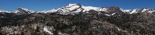
This 4x5 Provia 100F image was taken from near Ebbetts Pass above 9k looking south on July 30, 2011:

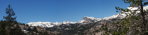
I took this 4x5 Provia 100F image of Red and White Mountain down canyon from the northeast on August 12, 2011:

Two of us backpacked up McGee Creek for 5 days. Some areas above 10k had a lot of mosquitoes. We were well covered with clothing as usual and DEET on faces and hands so were fine. Brookie fishing was good. We base camped at 10300 feet about a mile northeast of Big McGee Lake where landscapes were drier with more flowers about. In the image, that is the area above the rock face frame just below mid right edge. Note a snow bank there in what is a meadow. Within a half mile of that lake, there was still a minor amount of melting snow about the canyon bottom below shade of trees and green plants were just emerging. Going over Hopkins Pass would have encountered a lot of snow into September.
http://mapper.acme.com/?ll=37.49791,-118.81945&z=15&t=T
I took this 4x5 Provia 100F image of Red and White Mountain down canyon from the northeast on August 12, 2011:
Two of us backpacked up McGee Creek for 5 days. Some areas above 10k had a lot of mosquitoes. We were well covered with clothing as usual and DEET on faces and hands so were fine. Brookie fishing was good. We base camped at 10300 feet about a mile northeast of Big McGee Lake where landscapes were drier with more flowers about. In the image, that is the area above the rock face frame just below mid right edge. Note a snow bank there in what is a meadow. Within a half mile of that lake, there was still a minor amount of melting snow about the canyon bottom below shade of trees and green plants were just emerging. Going over Hopkins Pass would have encountered a lot of snow into September.
http://mapper.acme.com/?ll=37.49791,-118.81945&z=15&t=T
-
KevinDo
- Topix Acquainted
- Posts: 69
- Joined: Thu May 14, 2015 10:52 am
- Experience: Level 4 Explorer
Re: Where did you go 2011?
Kibbie was still frozen in May in 2011? Hot damn. Was the bridge road closed back then? If there's still snow, I might try for it!
-
balzaccom
- Topix Addict
- Posts: 3114
- Joined: Wed Dec 17, 2008 9:22 pm
- Experience: N/A
Re: Where did you go 2011?
Beehive was in Yosemite was under 3-5 feet of snow on Memorial Day 2011

The Road to Loon Lake Campground west of Tahoe was not open: too much snow

Mono Creek was roaring above Lake Thomas Edison over 4th of July weekend

But by Labor the upper end of the Merced River drainage was pretty much snow free:

The Road to Loon Lake Campground west of Tahoe was not open: too much snow
Mono Creek was roaring above Lake Thomas Edison over 4th of July weekend
But by Labor the upper end of the Merced River drainage was pretty much snow free:
Check our our website: http://www.backpackthesierra.com/
Or just read a good mystery novel set in the Sierra; https://www.amazon.com/Danger-Falling-R ... 0984884963
Or just read a good mystery novel set in the Sierra; https://www.amazon.com/Danger-Falling-R ... 0984884963
-
jimmeans

- Topix Acquainted
- Posts: 93
- Joined: Fri May 28, 2010 6:47 am
- Experience: Level 3 Backpacker
- Location: San Diego
Re: Where did you go 2011?
Big trip for me in 2011 was Rowell Meadow to Shepherd Pass via Colby from August 14-21
Still some snow climbing towards Colby Pass from Colby Lake side. Lots of mosquitos at Seville Lake, Cloud Canyon and along the Kern-Kaweah. Kern-Kaweah and North Fork Kern were still flowing a lot, we had somebody fall over crossing the Kern.
Still some snow climbing towards Colby Pass from Colby Lake side. Lots of mosquitos at Seville Lake, Cloud Canyon and along the Kern-Kaweah. Kern-Kaweah and North Fork Kern were still flowing a lot, we had somebody fall over crossing the Kern.
- Kaweahs viewed from Colby Pass, August 18, 2011
- Milestone Basin, August 20, 2011
- Shepherd Pass snow field, August 20, 2011
-
TehipiteTom
- Founding Member
- Posts: 955
- Joined: Thu Aug 24, 2006 8:42 am
- Experience: Level 4 Explorer
Re: Where did you go 2011?
No big trips in 2011. July 4 weekend I did a 2-night trip in the West Walker River drainage.
In mid-July I did a 2-night trip to Nellie Lake in Kaiser Wilderness. Lots of snow at the lake, and campsites were in the patches between snowbanks.
In mid-July I did a 2-night trip to Nellie Lake in Kaiser Wilderness. Lots of snow at the lake, and campsites were in the patches between snowbanks.
-
JWreno

- Topix Regular
- Posts: 308
- Joined: Thu Feb 04, 2010 9:55 am
- Experience: Level 3 Backpacker
- Location: Reno
Re: Where did you go 2011?
We did a northbound JMT from mid August to Labor Day weekend. We started at Horseshoe Meadows and finished in Yosemite Valley. I have done the complete JMT two other times. We crossed significant snow on all the passes above or near 11,000 feet. Muir pass was the most difficult since the trail was under snow or flowing water for about 4 hours. The rest of the passes took about an hour or more compared to our other trips in 2008 and 2014. Many times we knew we were not on the trail but did the best we could following others footprints in the snow.
I loved the reduction of pack animals and manure because most of the passes were impassible by stock. The snow was impressive to see so late in August. Water was much more available even in areas that typically would be dry for that time of year.
This year we are only planning a one week trip in mid September to avoid bugs.I am taking 3 other vacations this summer related to astronomy events. We may spend the time in Emigrant wilderness since our last trip there was severely impacted smoke from the Rim fire in 2013. We may try to do a few 3 day weekend trips if my wife can find a few times that don't conflict with her coworkers already scheduled vacation. She recently moved to a smaller nursing unit and they only allow 2 people off on any day.
Jeff
-
JWreno
- Topix Regular
- Posts: 308
- Joined: Thu Feb 04, 2010 9:55 am
- Experience: Level 3 Backpacker
- Location: Reno
Re: Where did you go 2011?
I just took the time to review your impressive trip list for 2011. I won't be retiring for another 6-7 years. I am envious of your abilities to spend so much time in the wilderness. I may be 67 when I retire and would like to complete the PCT in one season if I can remain fit enough. We may buy a Ford Transit RV before then and I may get some trail support from my wife in the RV. Hopefully my son and wife will also join me on some of the more beautiful sections of the PCT.
Jeff
-
Hobbes
- Topix Fanatic
- Posts: 1120
- Joined: Wed Apr 27, 2011 8:09 am
- Experience: N/A
- Location: The OC
Re: Where did you go 2011?
Hiked from Leavitt meadow as we were driving to SoCal over Sonora pass in late June:
Lane lake 6/22/2011

Went on a family car camping trip and got in some day hikes in late August:
20 lakes loop - better half in front of @ N Peak/Conness 8/21/2011

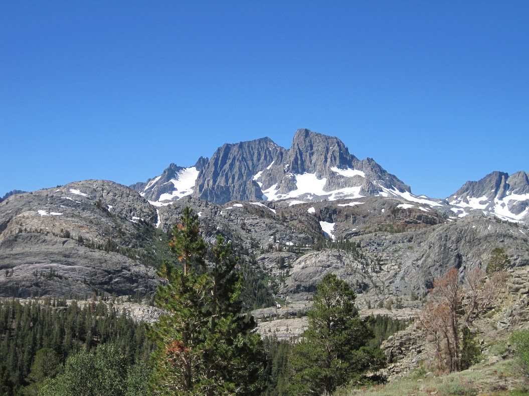
Rush creek loop - Ritter/Banner 8/23/2011
Took a trip into Miter basin in mid-September:
Sky Blue 9/17/2011

Lane lake 6/22/2011
Went on a family car camping trip and got in some day hikes in late August:
20 lakes loop - better half in front of @ N Peak/Conness 8/21/2011
Rush creek loop - Ritter/Banner 8/23/2011
Took a trip into Miter basin in mid-September:
Sky Blue 9/17/2011
-
Jimr

- Forums Moderator

- Posts: 2182
- Joined: Fri Jul 31, 2009 2:14 pm
- Experience: Level 4 Explorer
- Location: Torrance
Re: Where did you go 2011?
Only one trip in second week of August, 2011 over OAP and around to Miter Basin and Sky Blue Lk. Bagged Langley on the way out.
- Old Army Pass
- Miter Basin
- Sky Blue Lake outlet
- Camp at Sky Blue Lake (no, I'm not peeing in the lake)
- Langley Summit. SBL is at my right knee
If you don't know where you're going, then any path will get you there.
Who is online
Users browsing this forum: No registered users and 24 guests