I've been away for a while but hoping for a better year.
Like a few of you I received a email ad today concerning the general area.
I will say that I was checking this area out 2yrs ago but then "stuff" happened,
the advert jogged a memory.
Can anyone tell me about Morgan Lakes, lower and upper?
The map indicates a road to at least lower Morgan Lake, is that true,
is it still open/passable?
I would like to ride my KLR to either upper or the lower lake and make camp
for day hikes.
Got any images to post?
When do you think the area will be open this year?
Any fish in the area and over the Pass?
Thanks
Morgan Lake/Pine Creek?
-
frediver

- Topix Regular
- Posts: 268
- Joined: Sat Jan 13, 2007 11:15 pm
- Experience: N/A
- Location: n.cal
-
maverick

- Forums Moderator

- Posts: 12089
- Joined: Thu Apr 06, 2006 5:54 pm
- Experience: Level 4 Explorer
Re: Morgan Lake/Pine Creek?
No, the road ends just beyond the Pack Station, leaving you with a little over 5 miles of backpacking and around a 3100ftThe map indicates a road to at least lower Morgan Lake, is that true, is it still open/passable?
climb to Lower Morgan Lake which has Rainbows and Goldens.
Who knows this year, but keep in mind that Mt.Morgan and the ridgeline keeps the whole area shaded from the sun.When do you think the area will be open this year?
Not any more but Google "photo's of Lower Morgan Lake in the Sierra" and you will get plenty of photo's.Got any images to post?
Professional Sierra Landscape Photographer
I don't give out specific route information, my belief is that it takes away from the whole adventure spirit of a trip, if you need every inch planned out, you'll have to get that from someone else.
Have a safer backcountry experience by using the HST ReConn Form 2.0, named after Larry Conn, a HST member: http://reconn.org
-
gary c.
- Topix Fanatic
- Posts: 1479
- Joined: Tue Jan 24, 2006 4:56 pm
- Experience: N/A
- Location: Lancaster, CA
Re: Morgan Lake/Pine Creek?
Frediver, starting on page 11 of this link is some pretty good pictures of the Morgan Lakes including some fish pics. Let me know if the link does not work. I was too lazy to log out and sometimes that makes a difference.
http://www.rockcreeklake.com/board/inde ... ic=735.250
http://www.rockcreeklake.com/board/inde ... ic=735.250
"On this proud and beautiful mountain we have lived hours of fraternal, warm and exalting nobility. Here for a few days we have ceased to be slaves and have really been men. It is hard to return to servitude."
-- Lionel Terray
-- Lionel Terray
-
frediver
- Topix Regular
- Posts: 268
- Joined: Sat Jan 13, 2007 11:15 pm
- Experience: N/A
- Location: n.cal
Re: Morgan Lake/Pine Creek?
I hope we are speaking about the same area.
I goofed in the OP. The road is not along
pine creek but rather Morgan creek up to Morgan lakes.
I was just looking at Google Maps again and I do not
see the pack station you mention. Is it located at
the confluence of Pine & Morgan Creeks, I thought
those were old mine buildings ?
Thanks for the help.
I am now wondering if I should enter by way of
Rock Creek rd. ?
-
markskor

- Founding Member - RIP
- Posts: 2442
- Joined: Fri Oct 28, 2005 5:41 pm
- Experience: Level 4 Explorer
- Location: Crowley Lake and Tuolumne Meadows
Re: Morgan Lake/Pine Creek?
A few thoughts -
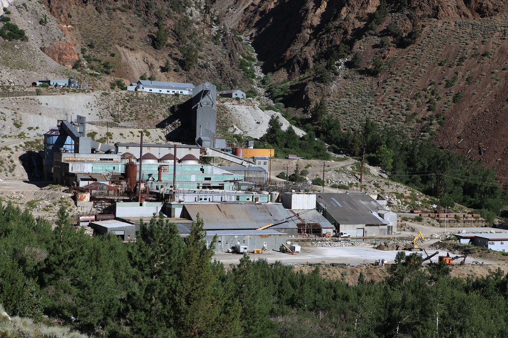
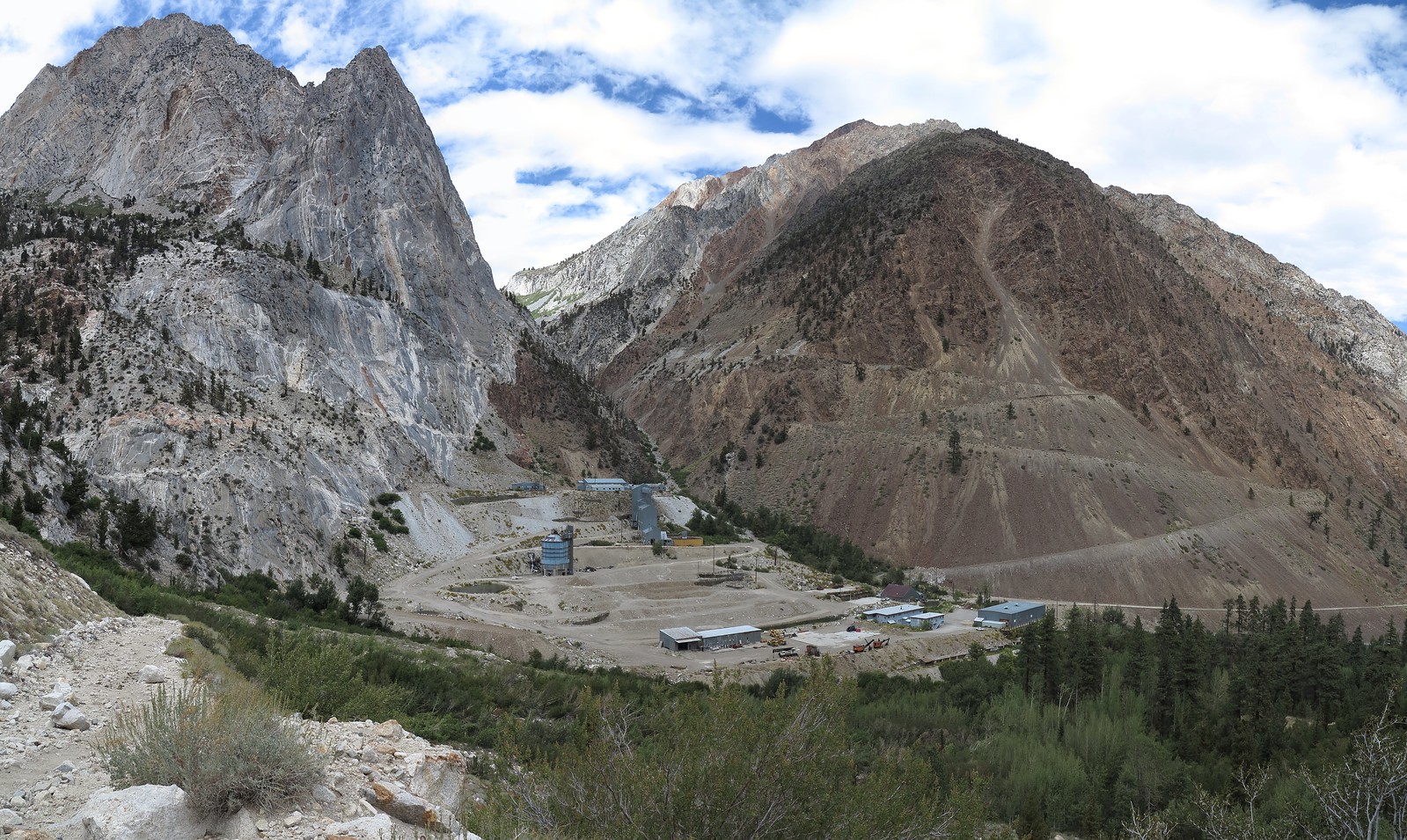
The Pine Creek road goes up only as far the old Tungsten Mine complex, and there is a pack station close by you can drive to - maybe a 1/2 mile away, located just below the tungsten mine parking lot. The other "road" you mention up to Morgan Pass - while still clearly visible from the Pine Creek Trail as it zig-zags up, has fallen into the impassible category - lots of loose boulders strewn about over the years.
BTW, still remember the words of the drover at the Pine Creek pack station - "Do not drink any water east of Morgan Pass (Lower Morgan lake) down to Pine Creek - lots of residual mining chemicals still abound."
This might suggest starting Rock Creek/ Mosquito Flats TH and down Pine Creek.
Mountainman who swims with trout
-
RoguePhotonic

- Topix Fanatic
- Posts: 1693
- Joined: Thu Mar 24, 2011 9:52 am
- Experience: Level 4 Explorer
- Location: Bakersfield CA
- Contact:
Re: Morgan Lake/Pine Creek?
I have wondered about the legality of driving that road up towards Morgan Pass. While coming down it in 2012 I was paying attention to the conditions and generally speaking the road is passable from outside the wilderness boundary about a mile below Lower Morgan Lake. There were tire tracks from a smaller off road vehicle such as an ATV up to this point. There was really only one location I was a bit skeptical about and that was a small bridge crossing a creek. It had holes in the middle of it but seemed to be solid if you kept nice and straight on it. There are two other rough rock sections but would not pose a problem for a 4X4 with decent tires.
The main question is there is a single post gate that was across the road in front of the primary mine complex. I did not see if it was locked or not. About a hundred yards into the road is a sign noting the property boundary. So not sure the fine details about getting access to this road and if it's possible or not.
Other than that I have camped at Lower Morgan Lake and drank the water there without filtering.
Scroll down some in this 2010 set from that area.
This 2012 set has plenty of pictures from there also. Take note of the main complex between 2010 and 2012. They removed allot of buildings.
Last edited by RoguePhotonic on Sat Mar 14, 2015 9:05 pm, edited 1 time in total.
-
Wandering Daisy
- Topix Docent
- Posts: 7053
- Joined: Sun Jan 24, 2010 8:19 pm
- Experience: N/A
- Location: Fair Oaks CA (Sacramento area)
- Contact:
Re: Morgan Lake/Pine Creek?
You can easily get to Morgan Lakes from Rock Creek. It is all huge trails and good road. Less elevation gain too. And good scenery on the way. I had good luck in the highest large lake.
-
Big Ed
- Topix Regular
- Posts: 120
- Joined: Sun Feb 24, 2013 12:00 pm
- Experience: Level 3 Backpacker
- Location: Fresno, CA
Re: Morgan Lake/Pine Creek?
I went through that area in 2000, came over Italy Pass, down to Pine Creek TH, then up to Morgan Lakes and out to Mosquito Flat TH. It would be much easier to get there from Mosquito Flat for sure.
-
RoguePhotonic
- Topix Fanatic
- Posts: 1693
- Joined: Thu Mar 24, 2011 9:52 am
- Experience: Level 4 Explorer
- Location: Bakersfield CA
- Contact:
Re: Morgan Lake/Pine Creek?
Although I agree it's much easier to go over Morgan pass I think it's worth a trip up this road from Pine Creek. The scenery in the area is awesome and on the unique side.
-
Big Ed
- Topix Regular
- Posts: 120
- Joined: Sun Feb 24, 2013 12:00 pm
- Experience: Level 3 Backpacker
- Location: Fresno, CA
Re: Morgan Lake/Pine Creek?
I had solitude from Pine Creek trailhead almost to Chickenfoot Lake. Side note, that's a bighorn sheep area, no dogs allowed. It is a very interesting area. I enjoyed not having the crowds, the trail was fairly crowded on the way out to Mosquito Flat trailhead.
Who is online
Users browsing this forum: khamike and 3 guests