Langley from Cottonwood Lake #5?
-
Ska-T
- Topix Regular
- Posts: 249
- Joined: Thu Apr 26, 2007 8:59 pm
- Experience: Level 4 Explorer
Langley from Cottonwood Lake #5?
I once read a post where a guy said he hiked Mt Langley from the cirque holding Cottonwood Lake #5. The pass is one col north of (old) Army Pass as roughly show on the map below. IIRC, the original poster said it was straightforward and a faster route than going over AP or NAP. Anyone do that route? I'm guessing it might have a cornice and one should wait for that route to melt out.
You do not have the required permissions to view the files attached to this post.
-
cgundersen

- Topix Fanatic
- Posts: 1338
- Joined: Sun Jul 16, 2006 1:07 pm
- Experience: N/A
Re: Langley from Cottonwood Lake #5?
ska-t,
I went over that ridge with another guy in early June 1984 and it was pretty much the boulder hopping climb you'd expect with broad snow patches till the top. At that point, there was about a 15 ft wall of snow with a small cornice. We dropped packs and took turns kicking holds into the compliant snow and then busting off bits of the cornice. After probably 30 min, I finally pulled myself over and my pal tied the packs to ropes and I dragged them up. Then he followed and we were pretty tickled that we did not have to turn around. It was a fun alternative to NAP. But, it might be a little dicier alone, or better if you have crampons/ice axe.
cg
PS. If I do some serious digging, I might be able to find photos, but I can't guarantee it. I'll have a look.
-
Mradford
- Topix Regular
- Posts: 325
- Joined: Sat Sep 03, 2011 3:03 pm
- Experience: Level 4 Explorer
- Location: Ladera Ranch
- Contact:
Re: Langley from Cottonwood Lake #5?
I went to Lake 5 a few years back and remember a ridiculous looking scree hill on the backside of the lake. I don't know about being easier as from the looks of things it would seem to be a huge pain in the butt. But looking at topos of the area it seems like it wouldn't be too bad.
-Mike
-Mike
-
sparky
- Topix Fanatic
- Posts: 1034
- Joined: Tue Jul 20, 2010 10:01 am
- Experience: Level 4 Explorer
Re: Langley from Cottonwood Lake #5?
I can't imagine it being faster than new or old army passes....they are a snap.....but I am not doubting it. Depends entirely on your abilities.
-
Wandering Daisy
- Topix Docent
- Posts: 6749
- Joined: Sun Jan 24, 2010 8:19 pm
- Experience: N/A
- Location: Fair Oaks CA (Sacramento area)
- Contact:
Re: Way NOT to climb Langley
I climbed Langly many years ago. It was a trip to do Langly and Mt Corcoran from Tuttle Creek. Getting up Tuttle Creek is a challenge in itself! RJ Secor was with us. He had to leave after the climb of Corcoran, but he wanted us to "check out" the NW Gully route for the update of his guidebook. We were game to try. It definitely is NOT a good way to climb Langly. Everything was fine as we started up until the sun hit the ridge and melted the top. Bowling ball size rocks came down the gully richocheeting off the rock walls as we literally had to dodge the rocks. We were about 2/3 of the way up and decided we would have less time in the gully going up than coming down. The top was snowy- lots of post-holing. We decided to try to descend the north ridge. Fine until we stayed on the ridge too long and ened up with about 100 feet of class 4-5 rock climbing (we had no rope) to get off the actual ridge. Although the map implies that there is a "trail" that descends the ridge, there is NO trail that stays on the ridge. Other excitment on this trip was running into eight mountain sheep near our camp and blowing up a stove while watching 4th of July fireworks down in the valley in the distance!
BAD ROUTE ON MT LANGLY

BAD ROUTE ON MT LANGLY
-
BrianF

- Topix Regular
- Posts: 296
- Joined: Thu Jul 06, 2006 1:29 pm
- Experience: Level 4 Explorer
- Location: Santa Barbara,Ca
Re: Langley from Cottonwood Lake #5?
Check out Bob Burd's trip report at this link - it may help http://www.snwburd.com/bob/trip_reports/langley_1.html" onclick="window.open(this.href);return false;
The direction you are moving in is what matters, not the place you happen to be -Colin Fletcher
-
Ska-T
- Topix Regular
- Posts: 249
- Joined: Thu Apr 26, 2007 8:59 pm
- Experience: Level 4 Explorer
Re: Langley from Cottonwood Lake #5?
Thanks for the direct information, stories, observations, and links guys. CG, sounds like you had an excellent adventure back in '84. I was interested in the route because on the topo it made sense, and observing it in late Fall from Lake #5 I didn't see any particular obstacles, and I figured it it would be more interesting than hiking up a trail I'm familiar with.
-
Ska-T
- Topix Regular
- Posts: 249
- Joined: Thu Apr 26, 2007 8:59 pm
- Experience: Level 4 Explorer
Re: Langley from Cottonwood Lake #5?
Here is what the Lake #5 route looks like vs Army Pass in late Oct 2005. In the absence of any other information except lakeside observation I would choose the Lake #5 route over Army Pass.
Army Pass
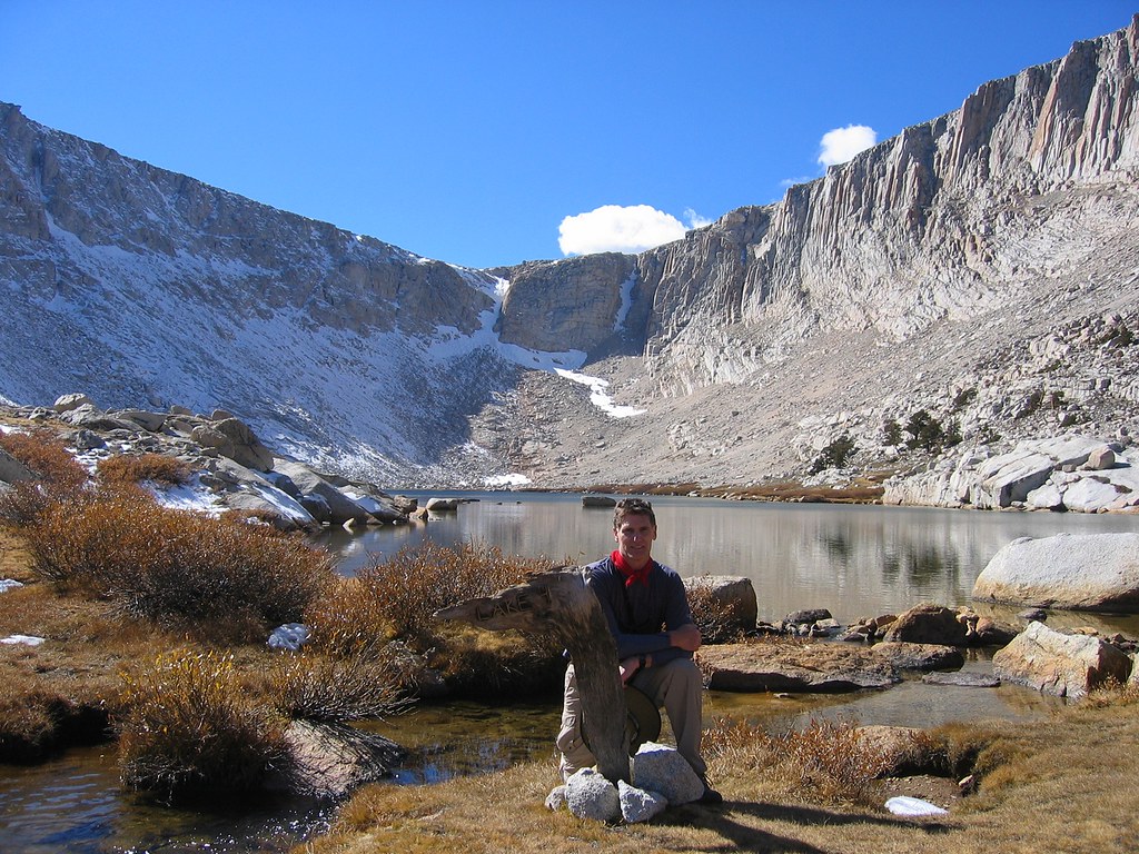
Lake #5 Cirque
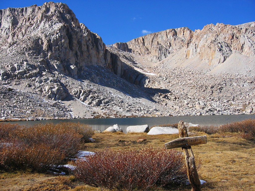
Army Pass
Lake #5 Cirque
-
BrianF
- Topix Regular
- Posts: 296
- Joined: Thu Jul 06, 2006 1:29 pm
- Experience: Level 4 Explorer
- Location: Santa Barbara,Ca
Re: Langley from Cottonwood Lake #5?
From your pics it certainly does look reasonable. Be sure to give us a TR and some pics
The direction you are moving in is what matters, not the place you happen to be -Colin Fletcher
-
calipidder
- Topix Regular
- Posts: 205
- Joined: Wed Jan 18, 2006 3:00 pm
- Experience: N/A
- Location: Above 10k
- Contact:
Re: Langley from Cottonwood Lake #5?
My friends have informally been calling that Navy Pass. I've never been up it but here is a photo of it that I took in late July 2010:

Still a pretty hefty cornice.
Still a pretty hefty cornice.
Who is online
Users browsing this forum: druid, Google Adsense [Bot], luigithekid and 11 guests