CARTRIDGE PASS
GENERAL OVERVIEW: This pass leads from Lake Basin to the South Fork of the Kings River from which you can take the Muro Blanco out west or go east and catch the John Muir Trail between Pinchot and Mather Passes
CLASS/DIFFICULTY: Class 1 to 2
LOCATION: Kings Canyon National Park, Cirque Crest HST Map
ELEVATION: 12,162 (ft).
USGS TOPO MAP (7.5'): Mt Pinchot, CA
ROUTE DESCRIPTION: Approaching from the north, travel through Lake Basin to the northernmost lake in the Basin. At the north end of that lake on the right side of the bowl look for the obvious finer sand and talus streaks in the cliff....this is your use trail. The first two thirds of your climb though not really exposed are steep with loose footing. However, two thirds up the pass you will come upon a small flat bench to catch your breath and views. From that bench the trail is less steep and exposed to the top. At the top enjoy lovely views back on Lake Basin as well as incredible views south towards Bench Lake, Arrow Peak etc Dropping down the south side you will find a decent non maintained use trail, possibly made in 1935 by Sierra Clubbers who made their largest ever expedition of the Sierra Nevada in this region with 100 travelers and enough stock to maintain them on the trip. The trail drops down several hundred feet to a nice lake, then goes over a cliff and drops down 1,200 ft more into the canyon of the South Fork of the Kings. Dropping down to the river is hot, dusty and steep necessitating numerous small switchbacks. Once down to the river you face either numerous talus fields and world famous bushwacking to get thru the Muro Blanco, or you face several very long talus fields presenting you with hours and hours of talus field crossings to reach the John Muir Trail.
Cartridge Pass
-
ndwoods

- Founding Member
- Posts: 237
- Joined: Thu Nov 03, 2005 9:48 am
- Experience: N/A
- Location: Santa Cruz, CA
- Contact:
Cartridge Pass
- Attachments
-
-
RoguePhotonic

- Topix Fanatic
- Posts: 1695
- Joined: Thu Mar 24, 2011 9:52 am
- Experience: Level 4 Explorer
- Location: Bakersfield CA
- Contact:
Re: Cartridge Pass
The old trail on this pass can be easily followed over the entire pass on both sides.


-
lostcoyote

- Topix Regular
- Posts: 262
- Joined: Tue May 29, 2007 9:11 pm
- Experience: N/A
Re: Cartridge Pass
"Dropping down to the river is hot, dusty and steep necessitating numerous small switchbacks. Once down to the river you face either numerous talus fields and world famous bushwacking to get thru the Muro Blanco, or you face several very long talus fields presenting you with hours and hours of talus field crossings to reach the John Muir Trail."
I do not recall this being the case.
i went from lakes basin to the JMT so my perspective here is going downhill and upstream along the kings.
beginning at lake 3310m, the trail stays along the east side of the outlet creek making some switchbacks along the way. not quite 1/2 way down, the trail veers slightly east and then makes the remaining switchbacks down to the kings in a set of switchbacks. i do not remember them being hot & dusty but i guess they could be if you are going uphill when the sun is at its peak.
upon arriving at the kings, i arrived at an old established campsite that has a HUGE firepit mound... and so if that is still there, that's a good marking to begin looking for the trail if headed uphill. the mound is on the north side of the river.
i crossed the river and had to travel thru some downed trees from avalance in several spots. some bushwhacking is also involved but it really was not very severe. it's much easier than staying on the north side of the river where one would have to cross some large talus slides.
travel becomes very easy once within a mile of the JMT where it's better to cross over to the north side of the river (as marked on the map.)
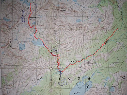
here is a map (showing the notes i scribbled down at the time) showing the location of the switchbacks. i've added red highlighter to my image for greater clarity:
I do not recall this being the case.
i went from lakes basin to the JMT so my perspective here is going downhill and upstream along the kings.
beginning at lake 3310m, the trail stays along the east side of the outlet creek making some switchbacks along the way. not quite 1/2 way down, the trail veers slightly east and then makes the remaining switchbacks down to the kings in a set of switchbacks. i do not remember them being hot & dusty but i guess they could be if you are going uphill when the sun is at its peak.
upon arriving at the kings, i arrived at an old established campsite that has a HUGE firepit mound... and so if that is still there, that's a good marking to begin looking for the trail if headed uphill. the mound is on the north side of the river.
i crossed the river and had to travel thru some downed trees from avalance in several spots. some bushwhacking is also involved but it really was not very severe. it's much easier than staying on the north side of the river where one would have to cross some large talus slides.
travel becomes very easy once within a mile of the JMT where it's better to cross over to the north side of the river (as marked on the map.)
here is a map (showing the notes i scribbled down at the time) showing the location of the switchbacks. i've added red highlighter to my image for greater clarity:
-
ndwoods
- Founding Member
- Posts: 237
- Joined: Thu Nov 03, 2005 9:48 am
- Experience: N/A
- Location: Santa Cruz, CA
- Contact:
Re: Cartridge Pass
Maybe talus is the wrong word? Several fields of very large chunks of granite that you get across by hopping from chunk to chunk....?
http://ndeewoods.com/" onclick="window.open(this.href);return false;
-
Wandering Daisy

- Topix Docent
- Posts: 7070
- Joined: Sun Jan 24, 2010 8:19 pm
- Experience: N/A
- Location: Fair Oaks CA (Sacramento area)
- Contact:
Re: Cartridge Pass
UPDATE. Sept 2013. A good use-trail starts off the JMT on the north side of the river. Spot the sign that says "no camping- restoration", and cross a small gully and shortly you find a distinct trail. Horsemen had recently used this trail, so it was easy to find. There are a few places where you go through deadfall (looks like avalanche debris) where you really have to pay attention. The trail stays on a bench, then drops to the river. Do not cross the river! Just before the trail looks like it goes to the river, poke around and you find a use-trail that continues on the north side. Again, horsemen have used this trail, so you follow the horse poo! This trail stays close to the river and would be swampy early season, but was dry when I did it. There are sections where you have to go through some tall willows, but the trail skirts the lower edge of the two upper talus cones. I think it also skirts the third talus cone, but becomes very faint and essentially ends in the forest between the second and third talus cone. Hop the rocks across the lower end of the third talus cone and you come to another large relatively flat forested area. Here you have to hunt for the trail.
The trail up the slope to the unnamed lakes at 3300 has been severely eroded since I last did the trail a few years ago. I suspect a lot of damage was due to the same storms of 2013 that wiped out parts of Shepherd Pass trail. The trail from up to the small lake at 3450 is hard to find (I missed it) but a very distinct trail starts at the outlet of this lake. The north side down has also been severely eroded since I was last there. The top part is OK, but the short steep section below is nothing but wash -outs and interwinding use trails.
The trail up the slope to the unnamed lakes at 3300 has been severely eroded since I last did the trail a few years ago. I suspect a lot of damage was due to the same storms of 2013 that wiped out parts of Shepherd Pass trail. The trail from up to the small lake at 3450 is hard to find (I missed it) but a very distinct trail starts at the outlet of this lake. The north side down has also been severely eroded since I was last there. The top part is OK, but the short steep section below is nothing but wash -outs and interwinding use trails.
-
richapple

- Topix Acquainted
- Posts: 50
- Joined: Wed Aug 04, 2010 12:30 pm
- Experience: N/A
- Location: Santa Cruz, CA
Re: Cartridge Pass
Good (and informatively sobering) update from Wandering Daisy for the current conditions for Cartridge.
(And to clarify - we've not done Cartridge Pass yet, and like lots of HST folks, always find it coincidental that Wandering Daisy is doing the very hikes we're planning. Not so coincidental, though when you think about it, because Wandering Daisy is pretty much wandering all over up there the entire backpacking season, which is wonderful.)
It's sounding to me like the recent erosion of the trail up to the first lake at 3300 from the south could slip the steep, very-unmodern and unmaintained trail from the difficult-but-feels-safe category to the now-this-is-scary category, but more-so I'm worried about the "short steep section" for the last drop down to the first Lake Basin lake on the north side.
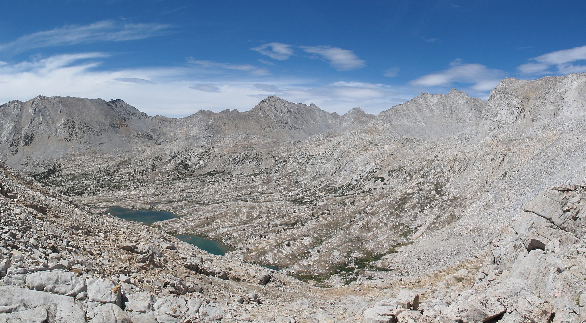
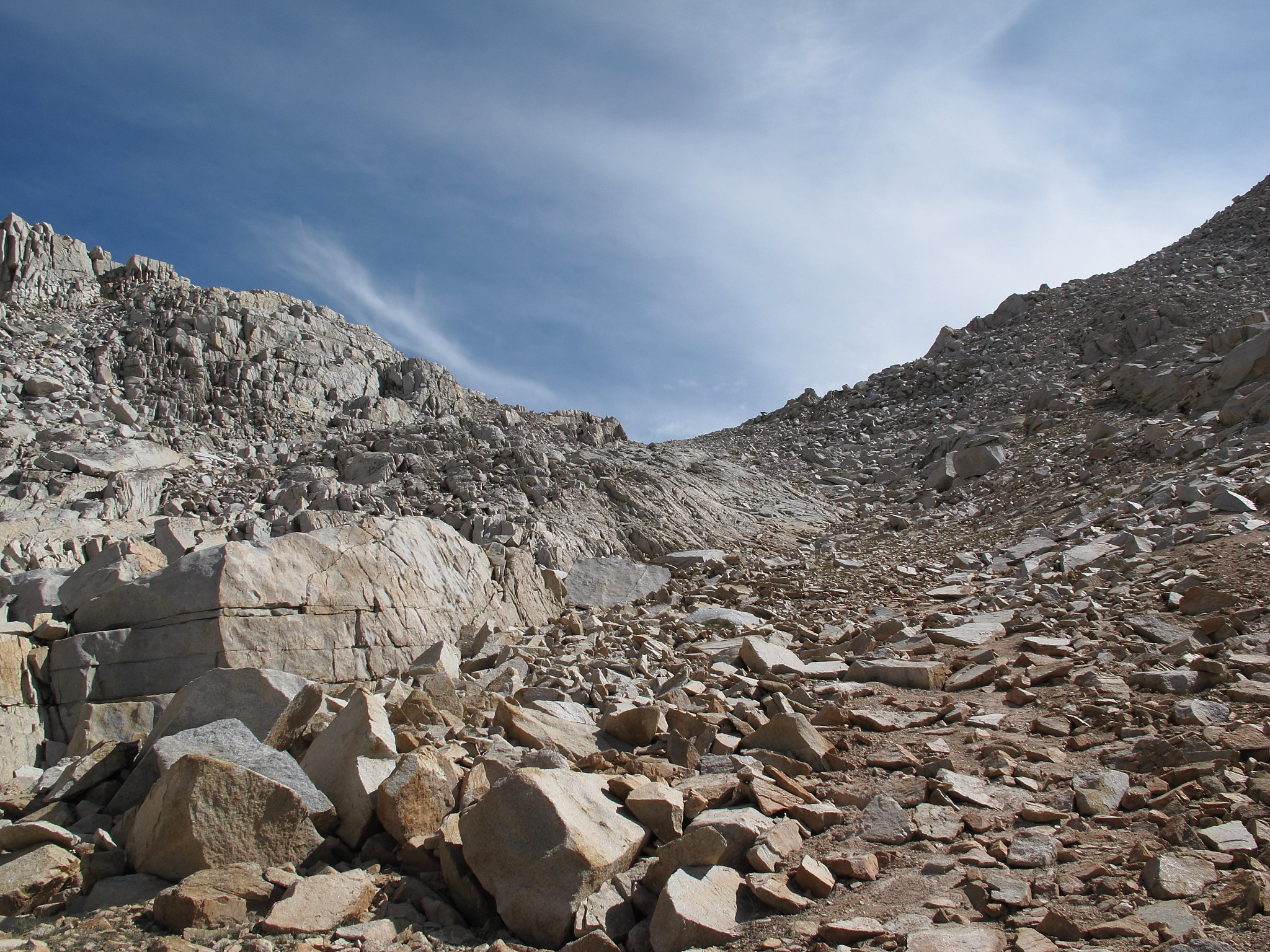
From reading other descriptions and from Google-Earthing I've concluded that the best route on the north side stays east, kind of hugging the cliffs (and left of the three stooges buttresses I've circled in red from this topic's original photo by ndwoods, which is looking at the pass from the north - and sorry ndwoods to mess with your photo).

It sounds like hiking up out of Lake Basin from the north it's easy to miss where the trail swings left under the buttresses to then do its better route close to the cliffs, and if you miss that and end up west of the buttresses it's a steeper "spur" which you'd rather avoid. (Those three buttresses are pretty obvious in the last photo in the series shown by RoquePhotonic, but that photo does have to be taken with the camera angle looking up the mountain and not so, uh, revealing of how friggin' steep it actually is.)
So I guess if I could find out anything more before deciding whether to try this crazy thing or not, it would be this: Does the damage (likely from the T-Storms of July 2013) change the Cartridge Pass trail from something that mere mortals can do? Or does "nothing but wash-outs and interwinding use trails" mean that there's a whole lot more of difficult, uncertain steps where one could lose it and tumble down the slope at any time?
As for the "we can do all this for sure" stretch along the South Fork of the Kings (Old JMT from the new JMT), it sounds like Wandering Daisy's "Do not cross the river!" speaks from experience. The "approximate location" trail shown on Topos (that does show crossing the river) is likely old and since then the overgrowth and avalanches, etc., south of the river has pretty much had this part of the old trail go to seed, eh? But, uh, early season it might still be necessary if one doesn't want to go full talus across the first two talus cones (which can be skirted close to the river in a dry late season).
(And to clarify - we've not done Cartridge Pass yet, and like lots of HST folks, always find it coincidental that Wandering Daisy is doing the very hikes we're planning. Not so coincidental, though when you think about it, because Wandering Daisy is pretty much wandering all over up there the entire backpacking season, which is wonderful.)
It's sounding to me like the recent erosion of the trail up to the first lake at 3300 from the south could slip the steep, very-unmodern and unmaintained trail from the difficult-but-feels-safe category to the now-this-is-scary category, but more-so I'm worried about the "short steep section" for the last drop down to the first Lake Basin lake on the north side.
From reading other descriptions and from Google-Earthing I've concluded that the best route on the north side stays east, kind of hugging the cliffs (and left of the three stooges buttresses I've circled in red from this topic's original photo by ndwoods, which is looking at the pass from the north - and sorry ndwoods to mess with your photo).
It sounds like hiking up out of Lake Basin from the north it's easy to miss where the trail swings left under the buttresses to then do its better route close to the cliffs, and if you miss that and end up west of the buttresses it's a steeper "spur" which you'd rather avoid. (Those three buttresses are pretty obvious in the last photo in the series shown by RoquePhotonic, but that photo does have to be taken with the camera angle looking up the mountain and not so, uh, revealing of how friggin' steep it actually is.)
So I guess if I could find out anything more before deciding whether to try this crazy thing or not, it would be this: Does the damage (likely from the T-Storms of July 2013) change the Cartridge Pass trail from something that mere mortals can do? Or does "nothing but wash-outs and interwinding use trails" mean that there's a whole lot more of difficult, uncertain steps where one could lose it and tumble down the slope at any time?
As for the "we can do all this for sure" stretch along the South Fork of the Kings (Old JMT from the new JMT), it sounds like Wandering Daisy's "Do not cross the river!" speaks from experience. The "approximate location" trail shown on Topos (that does show crossing the river) is likely old and since then the overgrowth and avalanches, etc., south of the river has pretty much had this part of the old trail go to seed, eh? But, uh, early season it might still be necessary if one doesn't want to go full talus across the first two talus cones (which can be skirted close to the river in a dry late season).
richapple
-
Wandering Daisy
- Topix Docent
- Posts: 7070
- Joined: Sun Jan 24, 2010 8:19 pm
- Experience: N/A
- Location: Fair Oaks CA (Sacramento area)
- Contact:
Re: Cartridge Pass
The "trail" and pass are not scary at all, just steep and a grunt if going up and slow and hard on knees going down. Trekking poles are essential, in my opinion. It is not like you are going to kick loose an avalanche of rocks, but place feet carefully so you do not roll a rock on your foot or sprain an ankle. The trail is just a lot more miserable than when I did it about 6-7 years ago. I went down the gully to the left of the red circled buttress. That is where most of the footprints went. All the rains have also put a layer of dirt over lots of rocks so footing is a bit slippery.
-
Optimus-00
- Topix Novice
- Posts: 15
- Joined: Tue Aug 26, 2014 2:01 pm
- Experience: N/A
Re: Cartridge Pass
I just took a Sierra Club group over Cartridge Pass, from south to north. The trail was easy to find above a minor meadow along the South Fork, and it was not hard to follow on its steep ascent of the canyon wall. Just as you think you're going to face a big talus field, the route makes a lateral move to the west across a flat bench on the slope, taking you closer to the creek. (finding) that lateral move was the only tricky aspect of the ascent, the old trail is really not very hard to discern.
Coming down the Lake Basin side, the route is again fairly clear, if steep and loose. The perch halfway down is a good place to catch your breath, before committing to the even steeper section still to come, which is quite slippery, down into the boulders at the base. Before you know it, you're on the bottom and sitting in beautiful Lake Basin.
Coming down the Lake Basin side, the route is again fairly clear, if steep and loose. The perch halfway down is a good place to catch your breath, before committing to the even steeper section still to come, which is quite slippery, down into the boulders at the base. Before you know it, you're on the bottom and sitting in beautiful Lake Basin.
-
isaacr
- Topix Novice
- Posts: 7
- Joined: Fri Sep 01, 2023 9:37 am
- Experience: Level 2 Backpacker
Re: Cartridge Pass
I did it earlier in Sept 2024 and just speaking for the part where it ascends from South Fork Kings River and ends in the Lake Basin, it's pretty easy to follow the traces, the use trail is obvious in a lot of places. If you're following along on a GPS map like Gaia, the actual trail itself lines up pretty closely. I didn't do the section connecting back to the JMT but I met two parties who had come that way and it didn't seem too difficult.
-
frozenintime
- Topix Regular
- Posts: 346
- Joined: Tue Aug 18, 2015 8:06 pm
- Experience: N/A
Re: Cartridge Pass
i've gone north once and south twice. it's in pretty good condition with a few exceptions (heading s to n):
-- finding the start of the trail by the kings can take a minute. in my memory, it starts in an open clearing. there was even a large arrow made of sticks in 2017.
-- the trail gets lost in the grass around 'cartridge lake' -- i don't think the trail does the odd dogleg at the north end of the lake as drawn on the usgs map. finding where to rejoin the trail takes a minute, but it's roughly where the line is drawn: just to the east of the creek coming down from the higher lakes.
-- between the higher lakes and the top of the pass has always confused me. the caltopo use trail (drawn from OSM maybe?) is pretty good, though.
-- the north side of the pass is a mess of use trails, but mostly you're just plunging straight down to lake basin.
Who is online
Users browsing this forum: No registered users and 1 guest