An example below of how in this era a serious photographer uses online map and satellite resources on a desktop/laptop with today June 9, 2024. Ought to complete in a few days, HTML coding and uploading into my website of all my considerable and surprising productive spring a6700 work to this point. After that will concentrate on this late June backpack.
Will likely at short notice, obtain a midweek solo backpack wilderness permit on recreation dot gov a few days before this tentative trip dependent on weather conditions of sun and a clear dry atmosphere without thunderstorms or strong wind. So will morning drive east via US50 to Tahoe. On the Copernicus.eu browser, these areas have just now melted out and given a warm forecast, shows the region in the near period will be under a heat dome. So I can expect given experience, that in 2 weeks or June 23+, vegetation greenery and early wildflowers will have exploded. In the distance west, areas with patchy snows will still grace green landscapes while foregrounds ought contain optimal elements for best images. May even manage some reflections off snow melt ponds. A good lower gear weight summer warm up trip for this old guy lugging his new Sony a6700 with focus bracketing.
On a mid day from the Glen Alpine trailhead at 6550, I'll be taking El Dorado National Forest trail 17E06.1, a rocky trail with scree, that goes to Gilmore Lake but not quite to that lake at 8320 feet. Instead will set up about a half mile southeast about a Mt Tallac slope stream zone off the trail at the rim of the canyon at about 8250 feet at 38°53'16.76"N 120° 6'25.49"W where I've made a Google Earth (GE) placemark, I've named TallacW-camp that I can easily map locate for more analysis including jumping about point to point. That canyon rim knee is where winds from the west are stronger and Sierra juniper trees are most likely to be aesthetically wind shaped. The Glen Alpine Creek basin in my experience due to geology and elevation, has some of the most aesthetic junipers in the range that I've been occasionally working over decades. Since I hike slowly given carrying weight, that might be 3 hours including many brief stops along the route as am in no hurry and also prefer to enjoy these experience without too strenuous an effort. Thus may reach my camp zone mid afternoon while eastward light is still a bit harsh. That will allow some time for me to make a camp and relax.
https://caltopo.com/map.html#ll=38.8846 ... structures
The top of volcanic geology Mt Tallac at 9735, offers superb morning views westward towards Gilmore, Susie, Heather, Aloha, and the granitoid Crystal Range. From the above rim position that I've never actually walked, one is half the distance to Susie Lake versus the top of Tallac with more frame impact. Zoomed in, switched to the Caltopo NAIP base map, if one, selects the Ruler icon to measure Distance, yellow trail lines will appear. Then by switching the distance measurement mode back and forth, one will easily be able to make out this very lightly used old trail that isn't on the USGS topo.
https://caltopo.com/map.html#ll=38.8872 ... structures
Looking at the same area with Google Earth provides higher detail to the zone. By using the 6/29/2018 historical imagery that is near the same date of my visit with a few snow patches still melting, one will also note some shallow ephemeral ponds and trail 17E06.1 is more visible as well as mentioned junipers. By orienting that zone northwestward with Gilmore in the background and playing with 3D to level a bit, one will note a nice stream green zone with trees for shade I'll likely tent somewhere at and have added a GE placement, TallacW-camp. Then by placing the Street View icon there and rotating around for a westward view, one will see the morning view I expect. Since it is lower than the top of Tallac, one won't see Aloha and just a bit of Heather.
After working that zone that the day 2 morning, I'll climb up about 700 feet to a knob at 8920 below Tallac where it appears via GE that all those lakes including Gilmore, are visible including Pyramid Peak to rusty Dicks Peak. By adding a GE placemark at that location I've named Crystal-am1, I can always return to it. It also shows the exact location as: 38°53'48.85"N 120° 6'9.56"W. By GE zooming out and using its Ruler Distance tool, one will note from where I expect to camp, the Crystal-am1 placemark is almost directly towards the top of Tallac, 6900 feet horizontally away while Crystal-am1 shows 3600 feet. Next by placing the GE Street View icon at my camp zone, it will show the top of Tallac is often visible at ground level. Thus I should be able to directly visually navigate towards the slight knob with just photo gear, that may not be obvious until getting near. Below the GE Street View icon, one can use the smaller navigation circle to travel towards the top of Tallac. Doing so, eventually the placemark becomes visible that I'll expect and then change to visual hiking. On day 2 after working the knob by later morning, will drop back down to TallacW-camp, pack up and hike back downhill towards the trailhead I ought reach mid afternoon allowing a modest 4 hour daytime drive home.
On the caltopo Forest Service base map, one can also use the Ruler icon Bearing tool to find that route is a 21 degree bearing (a bit east of due north) or 8.5 degrees magnetic I'll complement enroute with my compass. The Bearing tool will also show Susie Lake is at 245 degrees from TallacW-camp and 230 degrees from Crystal-am1 that is a good orientation for 8am>9am landscape shadowing. On the Caltopo Forest Service base map, by actuating the Ruler Distance tool that then displays noted yellow overlay lines on trails, one can also measure the 17E06.1 trail trailhead to TallacW-camp distance by moving a computer Mouse atop the yellow lines and that shows 1.8 miles. One can also select the Ruler Profile mode to create a profile graph with data showing:
distance: 1.79mi range: 6622' to 8340' gross: +1717'
About 4pm on day 1, will dayhike northwest to another photo location on the rib west of Gilmore I've named GE placemark Gilmore-pm1 at 8560 elevation that shows 4550 feet horizontal distance up an easy 350 feet where I expect to have a 30mm lens mid ground view of all of nicely round and deep blue Gilmore with Tallac directly above in the distance with a bit of residual snows about slopes. Because that rib is near and tall to Gilmore, I cannot shoot this too late as sun shadows will move over the lake.
After visiting Gilmore Lake west shores below for possible eastward photos, may be back at camp by 6:30pm with plenty of time for cooking a can of soup dinner. By the 8:15pm, dusk sky colors westward over Dicks Peak ought to be interesting from one of the camp zone snow melt ponds for a possible reflection. Likewise at dawn from those same ponds, there may be a reflection of the pink Earth shadow over the Crystal Range with some color picked up by Susie in the distance. In the next couple weeks, will revisit these GE placemarks now temporarily saved on my laptop and along with some GE window captures and map captures, copy them to my old smartphone, I can during the trip use for reference.
Desolation Tallac warm-up photo backpack
-
SSSdave

- Topix Addict
- Posts: 3606
- Joined: Thu Nov 17, 2005 11:18 pm
- Experience: N/A
- Location: Silicon Valley
- Contact:
-
mschnaidt

- Topix Regular
- Posts: 255
- Joined: Fri Jan 28, 2011 5:58 pm
- Experience: Level 4 Explorer
- Location: Cameron Park, CA
Re: Desolation Tallac warm-up photo backpack
Sounds like a great warm up trip. I'm heading to Gilmore tomorrow for a 2 nighter.
Here is a pic of the area I took in Sept 22 from the Gilmore/Tallac trail.
Here is a pic of the area I took in Sept 22 from the Gilmore/Tallac trail.
- gps.png (3.55 KiB) Viewed 1893 times
-
SSSdave
- Topix Addict
- Posts: 3606
- Joined: Thu Nov 17, 2005 11:18 pm
- Experience: N/A
- Location: Silicon Valley
- Contact:
Re: Desolation Tallac warm-up photo backpack

Thanks for that nice image westward mschnaidt. Nice perspective for aesthetically shaped Gilmore. Since the 10-day weather forecasts are now available through June 27, I just committed to a $16 rec gov print at home, permit for Desolation Zone 29, hiking in on the 25th late morning for 2 nights though may just do 1. Copernicus.eu shows as of 6/17, there is nicely still much more snow on the Crystal Range and middle ground northern exposures while southwest slopes of Mt Tallac just has a few aesthetic patches left. I'm expecting despite its likely aesthetic value, there may be no signs anyone in recent years has camped there just like many places I visit because, 1) not next to a lake 2) not next to the trail. 3) no one has promoted it ever online
In 2019, about same dates but a heavier snow winter, I backpacked into nearby Halfmoon Lake where I did find significant numbers of wildflowers in some gravel soil areas well watered by terrain snow melt flows at that same orientation northeast of that lake that I am gambling at finding this trip about my proposed camp zones. The main quarry will be wind shaped Sierra juniper trees at the Tallac plateau canyon edge. That trip with a lot of photos including one above much is closer to Susie lake.:
https://www.davidsenesac.com/2019_Trip_ ... html#jul27
See that gray peak in front of the Crystal Range? That is right above Heather Lake and looks down obliquely on Aloha. I made a large multi column row stitch blend panel from there.
Ok folks as of tonight there was still uno, (one=1) permit left for Monday June 24, 12 for 6/25, and 13 for 6/26. So surprise...lots of permits left for any midweek others and note am fine with any others rambling independently into that area at same time and or tagging along some.
-
SSSdave
- Topix Addict
- Posts: 3606
- Joined: Thu Nov 17, 2005 11:18 pm
- Experience: N/A
- Location: Silicon Valley
- Contact:
Re: Desolation Tallac warm-up photo backpack
90% packed up and ready to go that was supposed to be a tomorrow post commute road trip in the evening to a dispersed off the highway sleep inside Forester spot.
But...just decided to cancel my above permit at recreation dot gov because NWS forecast for anywhere on that Tallac plateau is showing strong southwest and west winds for the full period of my permit. I've endured much windy constantly endless weather at times in Desolation and learned to avoid it as much as impossible. Wind that strong creates tripod and lens vibration issues and if during early morning can eliminate many aesthetic vegetation foregrounds at this peak green and flower period. And today with Internet weather info available for exact locations including at elevation, I can place that cursor right at my exact camp zone southeast of Gilmore.
Next possible lower wind window on 10-day forecasts shows June 28 to July 1 so will wait to pounce on anything. At least down at the southwest end of 6.5k Fallen Leaf Lake it shows near null early morning as the new month starts.
In the mean time for member's amusement, Carrizo Plain April 1, 2024:
-
SSSdave
- Topix Addict
- Posts: 3606
- Joined: Thu Nov 17, 2005 11:18 pm
- Experience: N/A
- Location: Silicon Valley
- Contact:
Re: Desolation Tallac warm-up photo backpack
Apparently I cannot cancel my original permit online with recreation dot gov that starts Tuesday even though they advise doing so to free up no shows situations even when one does not qualify for a refund that I didn't. Some kind of excuse about some wildernesses not set up to do so. Anyway, obtained another like permit for about a week from now when for what its worth there shows less wind as the large high offshore moves some. So will go up with the early July 4 week crowds. Had to commit because permits were looking scarce by month end.
Also created a much more useful overlay map for their zone quota system that uses a barely useful online map that is supposed to guide the public haha. Not perfect but much better to work with than their tiny map.
Also created a much more useful overlay map for their zone quota system that uses a barely useful online map that is supposed to guide the public haha. Not perfect but much better to work with than their tiny map.
-
SSSdave
- Topix Addict
- Posts: 3606
- Joined: Thu Nov 17, 2005 11:18 pm
- Experience: N/A
- Location: Silicon Valley
- Contact:
Re: Desolation Tallac warm-up photo backpack
Just returned from 6/30 7/1 7/2 to Gilmore Lake area. Area at peak aesthetic, very green and flowery, with snowy Crystal Range to west. Mount Tallac west slopes with rich volcanic geology, especially on benches east of Gilmore, possibly best wildflowers I've yet encountered in range. Still some snow patches in shade at 8200 feet. Fair numbers of trout surface feeding along shores. Very productive 2 days of photography. Will take a week+ to post process.
-
SSSdave
- Topix Addict
- Posts: 3606
- Joined: Thu Nov 17, 2005 11:18 pm
- Experience: N/A
- Location: Silicon Valley
- Contact:
Re: Desolation Tallac warm-up photo backpack
Completed post processing the most important image I discussed above in my OP. And it will be GOLD. Full image is 17100 by 6000 pixels so enough to make a huge mural. Conditions were obviously perfect for the maximum sunny early summer greenery and snow aesthetic. This was 6 frame stitch blend out of my 24mp a6700 with the Sigma DC DN 56mm lens, processed with Zerene Stacker and CS6.
Per above post, I had cancelled my first Toiyabe NF 3 day permit for a week earlier because of high winds that indeed occurred. Then saw another less breezy forecast window for Monday 7/1 thru Tuesday 7/2 so reserved another permit per above. I won't ever take the 17E06.1 short-cut trail again carrying a heavy pack. The volcanic scree gravel requires extra leg muscle effort both uphill and downhill to prevent sliding with each step. Still breezy Sunday, I was a dead lad after arriving. Explored a bit but didn't take any photos.
Never previously exploring this zone, I found my original camp zone per OP very green and flowery, but the ephemeral streams were just trickles. Enough for drinking water, but I am one that always wants to fully dunk in water each day if possible. Monday morning I was busy with near camp zone subjects so the big panorama needed to wait till my last morning. But Monday evening unexpectedly became very windy, I believe due to a dry inside slider into the Great Basin.
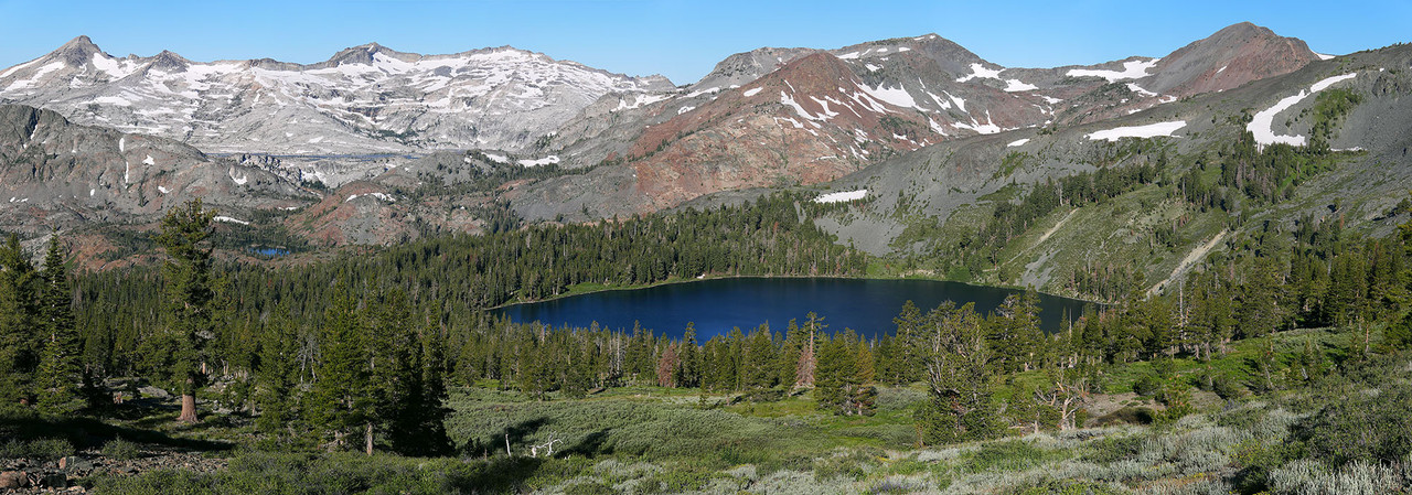
But by Tuesday dawn, wind had lowered enough that I hoped I could deal with it. I was camped maybe 200 yards from Gilmore Lake to the east out in the forest where others probably rarely venture. Thus at sunrise hiked the 600+ feet up towards Mount Tallac to the exact zone I'd analyzed per above. Was breezy, so set the foreground out far enough and just waited for enough breeze nulls on each frame. The a6700 Focus Bracket function did the rest. First took a modest 2 horizontal stitch with my 30mm lens at a different tripod spot but has shadows as the sun was just reaching foregrounds. Below is downsized for web, 2000 pixels wide or 1/8th the big image.
(right Mouse "Open image in New Tab)
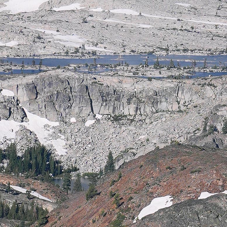
Two 777x777 pixel crops show how sharp the image is. That is Lake Aloha with Heather Lake.
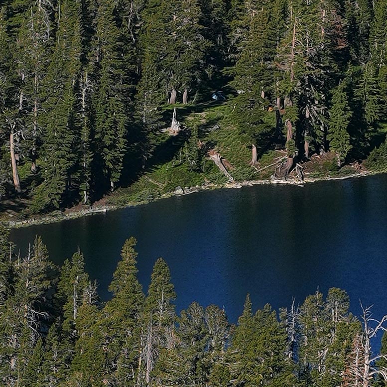
Gilmore Lake outlet zone. See the blue tent?
Per above post, I had cancelled my first Toiyabe NF 3 day permit for a week earlier because of high winds that indeed occurred. Then saw another less breezy forecast window for Monday 7/1 thru Tuesday 7/2 so reserved another permit per above. I won't ever take the 17E06.1 short-cut trail again carrying a heavy pack. The volcanic scree gravel requires extra leg muscle effort both uphill and downhill to prevent sliding with each step. Still breezy Sunday, I was a dead lad after arriving. Explored a bit but didn't take any photos.
Never previously exploring this zone, I found my original camp zone per OP very green and flowery, but the ephemeral streams were just trickles. Enough for drinking water, but I am one that always wants to fully dunk in water each day if possible. Monday morning I was busy with near camp zone subjects so the big panorama needed to wait till my last morning. But Monday evening unexpectedly became very windy, I believe due to a dry inside slider into the Great Basin.
But by Tuesday dawn, wind had lowered enough that I hoped I could deal with it. I was camped maybe 200 yards from Gilmore Lake to the east out in the forest where others probably rarely venture. Thus at sunrise hiked the 600+ feet up towards Mount Tallac to the exact zone I'd analyzed per above. Was breezy, so set the foreground out far enough and just waited for enough breeze nulls on each frame. The a6700 Focus Bracket function did the rest. First took a modest 2 horizontal stitch with my 30mm lens at a different tripod spot but has shadows as the sun was just reaching foregrounds. Below is downsized for web, 2000 pixels wide or 1/8th the big image.
(right Mouse "Open image in New Tab)
Two 777x777 pixel crops show how sharp the image is. That is Lake Aloha with Heather Lake.
Gilmore Lake outlet zone. See the blue tent?
-
SSSdave
- Topix Addict
- Posts: 3606
- Joined: Thu Nov 17, 2005 11:18 pm
- Experience: N/A
- Location: Silicon Valley
- Contact:
Re: Desolation Tallac warm-up photo backpack
(right Mouse "Open image in New Tab)
Above, another now processed set of focus stack and stitch blended images.
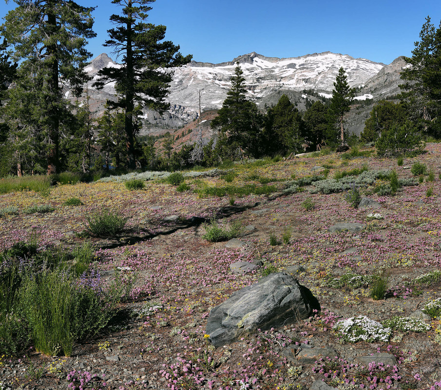
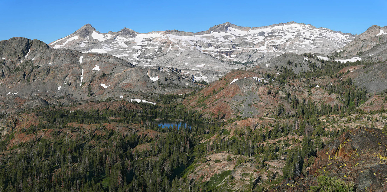
On Tuesday July 2, 2024 at 9am with a foreground of dense pu$$y paws, silver lupine, spreading phlox, single-stem groundsel, butterballs, metavolcanic rocks, red fir at left, lodgepole pine, snowy Crytal Range, and Susie Lake below Pyramid Peak at 9983 feet, poking through trees. Full image size 6900 by 6100 pixels, here downsized for web. I'd shot this landscape that is right along the Pacific Crest Trail on Monday afternoon and made sure to return for the better morning sunlight.
Below from a west southwest viewpoint at the canyon rim atop a rusty metavolcanic lichen covered Class 1 climbable outcrop with wind shaped Sierra juniper. Beautiful Susie Lake below with the snowy Crystal Range in the background. Full size focus stack and 4 column stitch blended image 12300 by 6100 mural printable size. Here downsized for web. Areas of the Glen Alpine Creek basin between 7k and 9k have some of the most spectacular wind shaped Sierra juniper trees in the range. But don't expect to see them by only walking trails. A visitor needs to get off trails and ramble about, efficiently guided with a topo.
(right Mouse "Open image in New Tab)
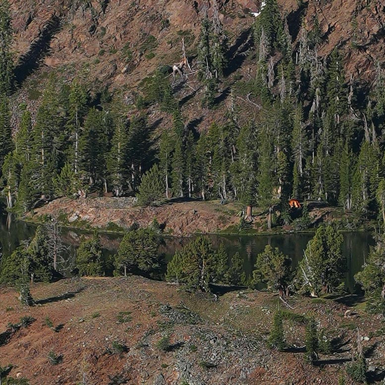
Below is a 100% pixels crop of the above image showing an orange tent with the level of detail.
Above, another now processed set of focus stack and stitch blended images.
On Tuesday July 2, 2024 at 9am with a foreground of dense pu$$y paws, silver lupine, spreading phlox, single-stem groundsel, butterballs, metavolcanic rocks, red fir at left, lodgepole pine, snowy Crytal Range, and Susie Lake below Pyramid Peak at 9983 feet, poking through trees. Full image size 6900 by 6100 pixels, here downsized for web. I'd shot this landscape that is right along the Pacific Crest Trail on Monday afternoon and made sure to return for the better morning sunlight.
Below from a west southwest viewpoint at the canyon rim atop a rusty metavolcanic lichen covered Class 1 climbable outcrop with wind shaped Sierra juniper. Beautiful Susie Lake below with the snowy Crystal Range in the background. Full size focus stack and 4 column stitch blended image 12300 by 6100 mural printable size. Here downsized for web. Areas of the Glen Alpine Creek basin between 7k and 9k have some of the most spectacular wind shaped Sierra juniper trees in the range. But don't expect to see them by only walking trails. A visitor needs to get off trails and ramble about, efficiently guided with a topo.
(right Mouse "Open image in New Tab)
Below is a 100% pixels crop of the above image showing an orange tent with the level of detail.
-
SNOOOOW

- Topix Regular
- Posts: 235
- Joined: Wed Mar 25, 2015 6:45 pm
- Experience: Level 4 Explorer
- Location: Gville
Re: Desolation Tallac warm-up photo backpack
Dave, what did you think of that trail, 17E06.1? I have been meaning to go to Gilmore that way for awhile now and finally just took the trail on the morning of Tuesday, July 2, with my dog and ended up just hiking up Tallac and back down the regular route back to Glen Alpine. That route to Gilmore is definitely how I will be getting to Gilmore going forward. It is steep but short, super efficient. I must have been hiking in while you were hiking out. Any bear sightings at/near Gilmore? The FS claims that Gilmore has a big "bear problem" but I have camped there multiple times and hike around that area every summer and have never ever seen a bear.
Last edited by SNOOOOW on Sat Jul 06, 2024 2:48 pm, edited 1 time in total.
Without a People's army, the people have nothing.
-
SSSdave
- Topix Addict
- Posts: 3606
- Joined: Thu Nov 17, 2005 11:18 pm
- Experience: N/A
- Location: Silicon Valley
- Contact:
Re: Desolation Tallac warm-up photo backpack
A good short cut to Gilmore for day hikers, trail runners, and those not carrying much weight. Not on the USGS, so few people are aware it is there or use it. Not recommended after later morning heat arrives because the first mile plus is without much shade, across dry brushy dark rock geology that radiates infrared heat. So an early morning choice. Also not recommended for backpackers carrying weight because there is much volcanic scree gravel one's boots are continually sliding on that makes both uphill and downhill more strenuous due to constant need to use breaking and balancing muscles.
100%, not equestrian possible. Mostly Class 1 but there are a half dozen Class 2 sections where use of hands is necessary and one short Class 3 section where a fall would at a minimum severely mangle one's body. Worst steep lose gravel section is the last 500 feet of vertical to the Tallac Gilmore junction that is also at the only sure flowing stream. Beyond the unsigned Tallac Gilmore junction, the unmaintained trail is sometimes a barely obvious path so not a trail to ever try night hiking.
As for bears, did see a huge dark scat. Since I almost never use lake or trail side camp spots, and there were endless more remote level ground choices, sited my tent about 200 yards, from the trail, well east of the lake and outlet stream in quiet deep flowery forest where few others ever bother to venture. Of course, the majority of visitors camp at any of several heavily used camp spots right beside the lake with many against policy, less than 100 feet from the water edge. For the sake of some privacy, and a wilderness feel, will suggest siting east of the outlet stream in any of many never before used flat spots with afternoon shading trees.
One last bit of advice. Bring foam flip flops or water shoes because wading into the lake for a refreshing dip is painful to bare feet given the sharp shape of volcanic golf ball to orange sized scree dominating lake edge shores. The west and south shores tend to be shallow so one cannot just dive into deeper water but must walk out a ways. And even now the lake waters are a pleasant not too cool temperature.
Who is online
Users browsing this forum: No registered users and 1 guest