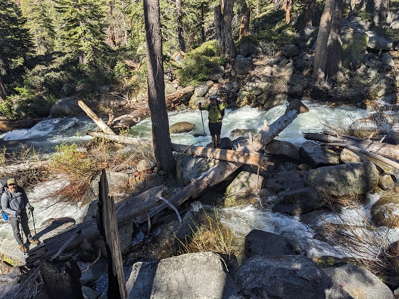
Lower on trail crossing: the log bridge is intact and was above water on both July 2 and 4
Upper on trail crossing: the log bridge has broken in the middle. It remains in place, but with a wide v shape. On July 2 some water was going over the low point of the log, on July 4 it was wet but no water overtopping the log.
It was easy to rock hop across the outlet of Piute Lake, but this make get harder if the lake level rises
2023 River/Stream Crossing Reports
-
clairekm

- Topix Newbie
- Posts: 1
- Joined: Sun Jan 22, 2023 6:29 am
- Experience: Level 4 Explorer
Bishop Creek North Fork along Piute Pass trail July 2-4
You do not have the required permissions to view the files attached to this post.
-
rayfound

- Topix Expert
- Posts: 476
- Joined: Thu Apr 24, 2008 4:44 pm
- Experience: Level 3 Backpacker
- Contact:
Cottonwood Creek July 3
Morning, low logs passable:
Afternoon - low logs a little too awash to favor.
Afternoon - low logs a little too awash to favor.
You do not have the required permissions to view the files attached to this post.
-
sierrahikingtree

- Topix Newbie
- Posts: 3
- Joined: Tue Feb 15, 2022 9:02 am
- Experience: Level 4 Explorer
Sabrina Lake - George Creek 8/7
Day hiked out of Lake Sabrina to do some recon for a trip later this month. I was hoping to make it to Blue/Dingleberry Lakes, but to no surprise, George Creek was running high. I decided to turn around and headed up to Little George Lake instead. I ran into one backpacker who traversed well above the trail to find a safer place to cross. Another group had one member that made it across on the trail (without his backpack), but given the abilities of the other members in his group, decided to turn around. He said it was above knee-high at the deepest point and he looked to be about 6 feet tall. The first photo below is George Creek on the trail. The second photo is above the trail a little bit. I found a possible (sketchy) crossing on some big boulders, but the risk/reward didn't make sense. Be safe out there everyone!
You do not have the required permissions to view the files attached to this post.
-
YosemiteW
- Topix Newbie
- Posts: 3
- Joined: Sun Jun 16, 2019 10:34 pm
- Experience: Level 3 Backpacker
Crossing Cold Creek on Goodale Pass Trail (Sierra National Forest) - July 8 2023
I hiked on Goodale Pass Trail toward Goodale Pass from Mono Creek trailhead at Vermilion on July 8th. This report is about crossing Cold Creek on the trail.
The lowest crossing point near VVR has a bridge and there is no problem.
The second crossing point is at 8830 ft. The creek was running high and the current was very rapid. It was not possible to cross it. At about 0.5 mile north east off the trail, there was a point with multiple big logs over the creek. I was able to cross the creek there.
The third crossing point is at 8930 ft. The top of the logs over the creek were covered with rapidly running water, and it was not possible to cross.
The pictures are (1) the second crossing point at 8830 ft (37.41, -118.97), and (2) the third crossing point at 8930 ft (37.42, -118.96). Both are on Goodale Pass Trail, crossing with Cold Creek.
You do not have the required permissions to view the files attached to this post.
-
tomba

- Topix Expert
- Posts: 496
- Joined: Sat Jun 18, 2011 12:50 pm
- Experience: Level 4 Explorer
- Location: Bay Area
West Fork Cherry Creek and Buck Meadow Creek 7/13-7/16
I crossed West Fork Cherry Creek on 7/13 at 4 pm the location described in the report by venturefar. The first (western) channel was the largest. Water was crotch deep for an average size guy. It was at my limit. Next time I would at least wear my hiking shoes (with socks and insoles removed), and perhaps I would wait till morning when the flow would be lower.
Crossing the outlet of Wood Lake (Buck Meadow Creek) was straightforward on a good log jam on 7/15 at 9am.
I crossed West Fork Cherry Creek near the trail from Gem Lake to Piute Lake on 7/16 at 9am. There were obvious signs that the creek was much higher the previous evening. Even in the morning the creek looked much too deep and too fast to cross in that area. I think the only possibility would be swimming across after finding an area with a long safe downstream stretch. After searching for about 500 meters downstream I found a couple of downed logs across the stream. I don't remember seeing them mentioned. I crossed the first log carefully on all fours (feet and hands).
-
Zoobs
- Topix Newbie
- Posts: 3
- Joined: Wed Aug 12, 2015 10:07 am
- Experience: N/A
Re: 2023 River/Stream Crossing Reports
Green Creek to East Lake. Anyone have input on making it to East Lake (permit is a week from now)? USSGS streamflow today is 206 cfs versus 45 cfs historical average. Thank you so much. Stu
-
JayOtheMountains

- Topix Acquainted
- Posts: 56
- Joined: Sat Nov 27, 2021 12:26 pm
- Experience: Level 4 Explorer
Re: 2023 River/Stream Crossing Reports
I feel it's going to be wet. Probably still a fair amount of water backed up into the meadows and the stream is going to be a bit tricky.
I'm actually encouraging you to go and give it a try. The conditions may not be what you expect, though, and you should be willing to turn back and salvage a good time elsewhere. This was the scene at Saddlebag Lake Resort two days ago [below]. They were able to clear the road to the resort, but not much else as you can see. Saddlebag lake is at 10K feet and is 7 miles roughly south of East Lake (9,400 feet). I wouldn't be surprised if you ran into snow above Green Lake.
Saddlebag Resort and lake in the foreground. Excelsoir Mountain in the distance (left-most peak) Black Mountain just to the right of it, with the Green Creek drainage on the other side.

Last edited by JayOtheMountains on Wed Jul 19, 2023 8:03 am, edited 1 time in total.
-
seamusperry
- Topix Novice
- Posts: 8
- Joined: Sat Dec 05, 2015 5:56 pm
- Experience: N/A
West Fork Granite Creek - 7/14-15
West Fork of Granite Creek near Clover Meadow was running extremely high as of mid July. We crossed at the confluence with Timber Creek, hoping to head up to Isberg Pass. Though there were several log pileups that created crossings, I would not recommend it as a viable route until water levels substantially drop. We crossed around 9 am and with dry logs, it was reasonable.

However, by the afternoon, when we attempted to re-cross, the logs were underwater. We uneasily slept above the crossing and were able to get across in the morning. However, water levels were rising - river levels on the 2nd day were higher than the day before. Logs were wet and quite slippery. We all felt like it was slip-and-die levels, so crossed slowly with our hearts in our throats.
For reference, the crossing was roughly 8000' and everything above 9K' looked completely white, so there's still plenty of moisture left to come down.
-
dbargaehr1
- Topix Regular
- Posts: 165
- Joined: Fri Sep 09, 2022 6:41 am
- Experience: Level 2 Backpacker
Isberg Pass July 24-29
July 24 - East Fork Granite Creek - crossable at trail to Cora Lakes. Verrrry cold. Water came to knees wt highest point.
July 24 - Cora Creek below Middle Cora - easy deadfall crossing just west of the trail. creek is easily crossable as well, less than 2ft deep.
July 25 - Chetwood Creek on Stevenson Trail - difficult access at trail crossing with heavy snow overhangs on south side. Crossing was maybe mid-calf at worst. Cold water!!!
July 25 - Long Creek confluence at North Fork San Joaquin - uncrossable. Absolutely raging.
July 25 - Hemlock Crossing on NF San Joaquin - severe snow weight damage to Hemlock bridge. Steel is torn from the abutment on the east side. Uncrossable. River crossing was a non-option/suicidal. Torrential. See attachment.
July 26 - Long Creek above Stevenson trail - crossable at mid-calf. XC from 1 mile SW of hemlock to Long Creek.
July 26 - Blue Creek - uncrossable until above the entrance to Upper Bench Canyon.
July 27 - Blue Creek at Upper Bench - only crossable once scaling the wall from lower to upper bench. Knee deep and swift. The cascades down the wall were insane.
July 27 - Long creek below Rockbound Lake - easy to hop over below the lakes in the meadow section. Braided and thin.
July 28 - Long Creek at Long Creek Trail - tough crossing. Had to jump a narrow section, but extremely swift. A fall would have been dangerous.
July 29 - East Fork Granite Creek - easier to cross on the way back out. Water temps much warmer even though crossed around same time of day. Maybe to mid-calf in deepest spot.
You do not have the required permissions to view the files attached to this post.
-
Zarka
- Topix Novice
- Posts: 12
- Joined: Tue Mar 21, 2023 10:12 am
- Experience: Level 4 Explorer
Rush Creek at JMT/PCT 7/21
Rush Creek at JMT/PCT intersection. On July 21 we were unable to make the crossing at 37.74381, -119.21116 because the bridge logs had collapsed below water level, but were able to cross waist deep at 37.74349, -119.21042. It turns out this was completely unnecessary: for SB hikers you don't have to cross at all, just go south until you hit the trail to Island Pass, and for NB hikers there is a perfectly good bridge just a little farther south at 37.74234, -119.21038
Who is online
Users browsing this forum: No registered users and 6 guests