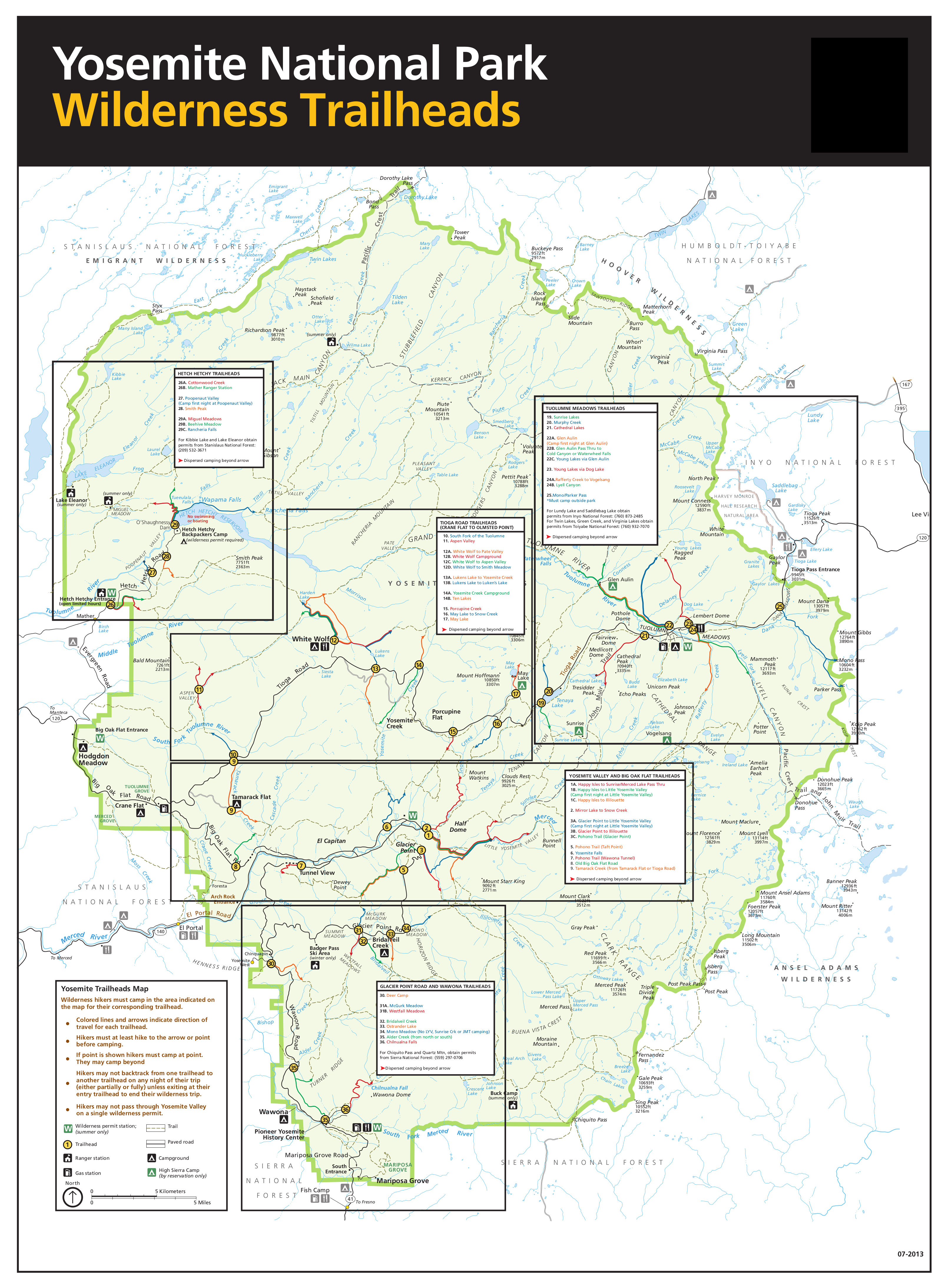
Dewey Point is on the Pohono Trail (south rim) and more than 4 trail miles from the Valley floor. On the North Rim, the "rule" has more to do with trail miles from the valley floor trailhead, so you have to move off the trail farther. There is a map that shows where camping is legal. Someone on this forum gave a link to the map; I do not remember where they found it.
Also, before Glacier Point Road opens, there are more "legal" camp areas along the Pohono Trail. In all the trips I have done from Yosemite Valley, once you get past the day-hiker range, there will be few people. You will see maybe 100 people going up Mist Trail or JMT to Little Yosemite Valley, and then meet only a few further on. Snow Creek Trail is not such a popular day-hike so less people. Yosemite Falls Trail is full of people between the Valley and top of the Falls. It also is open year-round so snow is not a problem going up or down. Pohono Trail is nearly empty of people early season when there is snow. One thing to consider is that the busses may not run in the valley this summer if COVID is still going and getting between upper valley and lower valley trailheads involves about 6 miles of walking if you cannot take a bus part way.
I do not think Lost Coast (spectacular and wild) would not be a feasible trip given your time frame. It takes an entire day to get the start (from Sacramento) and an entire day to get back when the shuttle is considered. I do not think you have that much time and it really needs to be timed for daytime low tides, which may not match your time frame. Point Reyes, although very beautiful, is very "civilized" and heavily used.
In Yosemite, you can also do trips from Hetch Hetchy. One that I have done very early season is TH to Rancheria Falls, then either the Vernon Lake loop; or an in-and-out up Rancheria Mountain to Pleasant Valley and climb Piute Peak.
New Sierra Backpacker - April/May Suggestions
-
Wandering Daisy

- Topix Docent
- Posts: 7052
- Joined: Sun Jan 24, 2010 8:19 pm
- Experience: N/A
- Location: Fair Oaks CA (Sacramento area)
- Contact:
-
robow8

- Topix Regular
- Posts: 343
- Joined: Wed Nov 13, 2013 5:17 pm
- Experience: N/A
Re: New Sierra Backpacker - April/May Suggestions
http://npmaps.com/wp-content/uploads/yo ... ad-map.jpgWandering Daisy wrote: ↑Sat Jan 01, 2022 5:12 pm There is a map that shows where camping is legal. Someone on this forum gave a link to the map; I do not remember where they found it.
https://www.nps.gov/yose/planyourvisit/ ... lheads.pdf
-
TxAggie
- Topix Acquainted
- Posts: 50
- Joined: Fri Dec 31, 2021 7:14 pm
- Experience: Level 3 Backpacker
Re: New Sierra Backpacker - April/May Suggestions
I’m glad you mentioned this, actually. I had completely forgotten to mention I lived in Monterey for a while and did some hiking in the old Fort Hunter Liggett back in the 90’s, and you’re right it was some very challenging and amazing terrain. I’m keeping my options open, especially if snow is heavy as they’re predicting now, so keep all options coming.c9h13no3 wrote: ↑Sat Jan 01, 2022 2:56 pm Peaks on the Lost Coast & Big Sur can drop 4000’ or more to the ocean in less than a few miles. The average elevation gain per mile is actually larger on rugged coastal terrain than the “Gentle Wilderness” of the Sierra. But I’ll stop selling you something you don’t want.
And if you’re planning on going into actually snowy terrain with snowshoes, I’d at least read Bruce Tremper’s book.
Could you elaborate on the book, please?
-
rlown

- Topix Docent
- Posts: 8224
- Joined: Thu Oct 25, 2007 5:00 pm
- Experience: Level 4 Explorer
- Location: Wilton, CA
Re: New Sierra Backpacker - April/May Suggestions
Nice to try and plan a trip for April now, but you'll have to wait to finalize your trip 10 days before you go based on the weather.
Watch the weather reports and snow load/stream flows before you even go. I like the Castle peak area as it would be close to Davis.
Peter Grubb hut is nice but is currently closed.
Took my wife up near Fort Hunter Liggett and hunted for pigs there on a separate trip. We were on a ridge just outside the fort and the bombs went off all night. Amazing.
Last edited by rlown on Sat Jan 01, 2022 8:56 pm, edited 2 times in total.
-
c9h13no3

- Topix Fanatic
- Posts: 1447
- Joined: Tue Sep 18, 2018 1:19 pm
- Experience: Level 1 Hiker
- Location: San Mateo, CA
Re: New Sierra Backpacker - April/May Suggestions
Ah, so you knowTxAggie wrote: ↑Sat Jan 01, 2022 6:06 pm I’m glad you mentioned this, actually. I had completely forgotten to mention I lived in Monterey for a while and did some hiking in the old Fort Hunter Liggett back in the 90’s, and you’re right it was some very challenging and amazing terrain. I’m keeping my options open, especially if snow is heavy as they’re predicting now, so keep all options coming.
Bruce Tremper's book Staying Alive in Avalanche Terrain is the bible for snow safety. For backcountry skiers, the general preparation is to take a 3 day avalanche course. For someone who just wants to snowshoe out to Lake Aloha in April and explore terrain that isn't steep for 3-4 days, that might be a bit overkill. But you should at least be aware of the basics: how to check the avalanche forecast (here's an example from April 18th), know what slopes to avoid when traveling & setting up camp, and know the warning signs that snow is unstable.
If you don't want to shell out the $12 or so, the AIARE I Manual is available online. If you avoid anything steep, and quit traveling when stuff gets sloppy in the afternoon, you should be good. But make a small effort to be aware of the hazards.
"Adventure is just bad planning." - Roald Amundsen
Also, I have a blog no one reads. Please do not click here.
Also, I have a blog no one reads. Please do not click here.
-
Wandering Daisy
- Topix Docent
- Posts: 7052
- Joined: Sun Jan 24, 2010 8:19 pm
- Experience: N/A
- Location: Fair Oaks CA (Sacramento area)
- Contact:
Re: New Sierra Backpacker - April/May Suggestions
http://cdec.water.ca.gov/snow/current/snow/index.html
This is the website to use to track the snow conditions. It also has links to more snow data sources.
This is the website to use to track the snow conditions. It also has links to more snow data sources.
-
paul
- Topix Expert
- Posts: 905
- Joined: Thu Mar 15, 2007 3:35 pm
- Experience: N/A
Re: New Sierra Backpacker - April/May Suggestions
There are a few of us here on the forum who make a habit of following the snowpack info pretty closely, so I would suggest reviving this thread around the first of April. By then we can be of much more help.
However, a little bit of info is generally true for that time of year. Mainly, whatever snow there is is mostly pretty consolidated by then. Late April/early May is what is often referred to as the "corn season" for the high Sierra, when the snowpack has firmed up and the freeze/thaw cycles make for a lovely surface texture, ideal for ski touring. What that means for walking on the snow is that you want to get up early and get going while the surface is crusty and firm, and cover some ground before it softens up. By mid afternoon or earlier, you can be postholing fairly deep. Of course, typical is not neccessarily how it will be, but it's a good thing to keep in mind. Also, stream crossings must be considered with deep respect, as streams are running high at that time of year.
However, a little bit of info is generally true for that time of year. Mainly, whatever snow there is is mostly pretty consolidated by then. Late April/early May is what is often referred to as the "corn season" for the high Sierra, when the snowpack has firmed up and the freeze/thaw cycles make for a lovely surface texture, ideal for ski touring. What that means for walking on the snow is that you want to get up early and get going while the surface is crusty and firm, and cover some ground before it softens up. By mid afternoon or earlier, you can be postholing fairly deep. Of course, typical is not neccessarily how it will be, but it's a good thing to keep in mind. Also, stream crossings must be considered with deep respect, as streams are running high at that time of year.
-
TxAggie
- Topix Acquainted
- Posts: 50
- Joined: Fri Dec 31, 2021 7:14 pm
- Experience: Level 3 Backpacker
Re: New Sierra Backpacker - April/May Suggestions
Thank you, will do. The group has already shared some great info.paul wrote: ↑Mon Jan 03, 2022 5:25 pm There are a few of us here on the forum who make a habit of following the snowpack info pretty closely, so I would suggest reviving this thread around the first of April. By then we can be of much more help.
However, a little bit of info is generally true for that time of year. Mainly, whatever snow there is is mostly pretty consolidated by then. Late April/early May is what is often referred to as the "corn season" for the high Sierra, when the snowpack has firmed up and the freeze/thaw cycles make for a lovely surface texture, ideal for ski touring. What that means for walking on the snow is that you want to get up early and get going while the surface is crusty and firm, and cover some ground before it softens up. By mid afternoon or earlier, you can be postholing fairly deep. Of course, typical is not neccessarily how it will be, but it's a good thing to keep in mind. Also, stream crossings must be considered with deep respect, as streams are running high at that time of year.
-
Harlen

- Topix Addict
- Posts: 2390
- Joined: Sat Mar 11, 2017 9:13 am
- Experience: Level 4 Explorer
- Location: Santa Cruz Mountains
Re: New Sierra Backpacker - April/May Suggestions
Daisy's makes a great suggestion to extend a North Rim trip out to Mt Watkins, El Cap., and Eagle Peak.
If you are keen to experience big dramatic Sierra mountain scenery, and not bothered by snow, I'll add the suggestion that you cross the range at Tioga, and go to the 20 Lakes Basin. First you must have the road open, ie, Hwy 120, but after that, you get the great benefit of an area with No Quota! You still need a permit, but it is a sure thing on any day. It is not too hard to fill 4 long days there, with long, high day hikes: up to the Conness Lakes Basin is one, Tioga Crest is another, up and over McCabe saddle and down to the beautiful McCabe Lakes is another. This last trip onto McCabe Saddle gives you long views deeper into the northern Yosemite backcountry.
Another ambitious trip you can do from 20 Lakes Basin would be to cross McCabe Saddle, and then link up with trails that wrap west, then southward around to meet Hwy 120 again within Yosemite Park. I believe (balzacom, check me if wrong) it is always allowed to enter Yosemite w/o a permit as long as you get an entry permit for your USFS trailhead. This idea would allow for a backpacking trip, rather than a series of day hikes, but you would need to return along the road to you car. There are sections of trail paralleling the road you could use too on the way back, through the old mining area of Bennetville, and from there into the basin west of the 20 Lakes Basin entry road. I'll add a few photos of some of this area. Yet another trip, which a friend and I have done, is to wrap around the "Shepherd's Crest" using the Roper High Route pass called Sky Pilot Pass, down into Virginia Canyon (which is stunning country), and then around through the McCabe lakes, and over McCabe Saddle, and back where you started. [here is a link to that trip report: viewtopic.php?f=1&t=20203&p=151990&hili ... ss#p151983]
This route entails a bit more in the way of mountaineering, but just on that first pass; if you make that, you're easy from there... DEPENDING ON SNOW CONDITIONS. Very important, post-holing with a backpack on can be exquisite torture. Snow shoes are lightweight insurance against that.
Good Luck TxAggie, it is vicariously exciting for us to imagine you on your first trip into the Sierra, Cheers, Ian.
North Peak from high in 20 Lakes Basin.
Shepherd's Crest above the high meadows below McCabe Saddle.
Virginia Canyon.
It could look more like this! Virginia Canyon, and Virginia Peak.
If you are keen to experience big dramatic Sierra mountain scenery, and not bothered by snow, I'll add the suggestion that you cross the range at Tioga, and go to the 20 Lakes Basin. First you must have the road open, ie, Hwy 120, but after that, you get the great benefit of an area with No Quota! You still need a permit, but it is a sure thing on any day. It is not too hard to fill 4 long days there, with long, high day hikes: up to the Conness Lakes Basin is one, Tioga Crest is another, up and over McCabe saddle and down to the beautiful McCabe Lakes is another. This last trip onto McCabe Saddle gives you long views deeper into the northern Yosemite backcountry.
Another ambitious trip you can do from 20 Lakes Basin would be to cross McCabe Saddle, and then link up with trails that wrap west, then southward around to meet Hwy 120 again within Yosemite Park. I believe (balzacom, check me if wrong) it is always allowed to enter Yosemite w/o a permit as long as you get an entry permit for your USFS trailhead. This idea would allow for a backpacking trip, rather than a series of day hikes, but you would need to return along the road to you car. There are sections of trail paralleling the road you could use too on the way back, through the old mining area of Bennetville, and from there into the basin west of the 20 Lakes Basin entry road. I'll add a few photos of some of this area. Yet another trip, which a friend and I have done, is to wrap around the "Shepherd's Crest" using the Roper High Route pass called Sky Pilot Pass, down into Virginia Canyon (which is stunning country), and then around through the McCabe lakes, and over McCabe Saddle, and back where you started. [here is a link to that trip report: viewtopic.php?f=1&t=20203&p=151990&hili ... ss#p151983]
This route entails a bit more in the way of mountaineering, but just on that first pass; if you make that, you're easy from there... DEPENDING ON SNOW CONDITIONS. Very important, post-holing with a backpack on can be exquisite torture. Snow shoes are lightweight insurance against that.
Good Luck TxAggie, it is vicariously exciting for us to imagine you on your first trip into the Sierra, Cheers, Ian.
Properly trained, a man can be dog’s best friend.
-
TxAggie
- Topix Acquainted
- Posts: 50
- Joined: Fri Dec 31, 2021 7:14 pm
- Experience: Level 3 Backpacker
Re: New Sierra Backpacker - April/May Suggestions
I figured it was time to revive this thread, and I might create a new one as plans have changed a little.
I’m still looking for a trip on a weekend between April 30 and Memorial Day, and happily my daughter has asked to join me. Plans are to leave Davis around noon on Friday and hopefully spend Friday and Saturday nights on the trail and returning to Davis Sunday afternoon.
Our first choice would be a Yosemite trip, but it seems the permit system process currently in place may mean we aren’t able to get a permit for Friday night, and maybe not even Saturday, especially given that it’s 3 plus hours from Davis to Yosemite Valley.
Our second choice is a short hike in Desolation Wilderness, most likely from Echo Lake up to Lake Aloha. We both realize there is a high probability is snow and postholing if we decide on this route, but it does offer a little more security in knowing it will be before permit season begins and we’ll almost certainly be able to find a route along this general path for two nights. It doesn’t hurt that the Echo Lake parking appears to be less than two hours from Davis.
Oh, one more thing: we’re both using hammocks instead of tents.
For those of you with first-hand experience with the quota system for Yosemite trails, is it even worth it to try for a walk up permit late on Friday? Or, since the route from Echo up to Aloha is relatively short, with several side trails to smaller lakes should the snow be too impassible up to Aloha, is this a more realistic plan? Or are both plans a bit too ambitious for our first California trip?
I’m leaning more towards Desolation, any advice is appreciated. I’m fairly experienced in mid-Atlantic winter camping, but not for the snow levels we might experience there. Will snowshoes be useful, or is the postholing just something that’s to be expected and travel mostly in the morning? I have a bear canister and an Ursak, are canisters required for Desolation? What about bear spray? We have black bears, but the ones here and in
Shenandoah are rarely aggressive.
Thanks for listening to my long diatribe, and thanks for any tips and suggestions.
Who is online
Users browsing this forum: SweetSierra and 11 guests