
Our shorter weekend trips to places like the Dinkey Lakes Wilderness and Mineral King have gone off without a hitch, but the scenery and wow factor has also been relatively subdued when only venturing a few miles in. Not quite as impressive as the stuff we'd see on weekend trips in Washington.
So I've been racking my brain for the perfect trip that would check all of the boxes: big mountain views, a scenic and challenging hike that isn't so hard it's miserable, interesting fishing, and solitude from the crowd of people who have just recently rediscovered outdoors adventures due to the pandemic keeping them off airplanes and away from bustling tourist destinations. After some deliberation, I decided on an itinerary that would take us from North Lake over Lamarck Col into Darwin Canyon, traverse west high above Evolution Valley to the unnamed lake at 11,092, cross down to Evolution Valley and follow the JMT only briefly before heading up again to visit an unnamed lake at the entrance of McGee Canyon, and then finally loop back to Darwin Bench/Canyon to complete the lollipop. I hoped that this route would take advantage of the scenery that the Evolution area is renowned for while limiting exposure to through-hikers on the JMT. I reserved our permit for Lamarck back in February, hoping schedules would actually hold together. And despite everything that's happened this year, this ended up being the one summer plan we had that ended up not changing. I emailed Inyo NF a week before our start date as per instructions on the reservation, and a staffer emailed me the permit the next day. All systems were a go.
Day 0:
On Friday, 8/14, we finished work and loaded up the car, then drove through the night across 108 to 395 (couldn't secure a day use permit for Yosemite that day, and the ETA using 108 vs. 120 wasn't that different anyway). Fueled by a couple of fat Chipotle burritoes courtesy of a DoorDash DashPass buy-one-get-one-free promo (if that sentence doesn't make sense to you, count yourself lucky -- this pandemic has made me a wizard at extracting discounts from the various food delivery/pick-up apps), we made it to the North Lake hiker parking lot just after midnight. We surreptitiously snuck a few Z's in the back of the CR-V, aided by the last half of a bottle of red blend we had neglected to finish off before we left the house. (NB: two bouldering pads wedged into the trunk space of a 2005 Honda CR-V EX with the back seats folded down creates a passable if cozy bed for two short people.)

Day 1:
Saturday morning (8/15), we arose at dawn and heated up some coffee while we tried and probably failed to appear like we had just arrived at the trailhead. We took care of morning business, then got our gear ready and were off for the actual trailhead by 7:45am. This would be one of the few times I'd started a trip by driving up the night before rather than the morning of, and we hoped that this would help us acclimate better than the last time. The trail up to Lower Lamarck Lake and then Upper Lamarck Lake went quickly, and soon we were on the unmaintained but very clearly obvious trail up to Lamarck Col.

I'd only been down this trail once before, in 2012, and have never hiked up. Though we were duly respectful of the steady elevation gain, we also enjoyed the changes in scenery as we climbed higher and higher toward the Col. A few trail runners passed us, but other than a few day hikers who stopped at Upper Lamarck these were the only people we'd encounter this day.

With energy waning, we stopped for a quick lunch break. We gave the trail runners wide berth as they trotted back down the trail, returning from the Col, and we secretly admired their tiny packs. Soon we were in view of the infamous ice field on the north side of Lamarck Col.

We bypassed the slippery usual route through the ice field using an easy Class 2 workaround to the southeast up some stable talus, and soon found ourselves at the Col. We celebrated with selfies with the KCNP entrance sign, and then descended down the other side. My wife declared that the view was amazing. Success!
Everyone's got a picture of Darwin Canyon from the Col, so here's one from lower down:

Having tumbled down the slope into Darwin Canyon proper, we ran into a solo backpacker who was headed out over Lamarck Col. He said he'd tried paths low, midway, and high through the f***ing talus field north of Lake #4 and couldn't decide if any of them were easier than the other. I shrugged -- by this time in the hike, my mind had turned to pursuits of the piscatorial perspective, so I had nothing to spare for optimizing talus hopping. We got ourselves through the talus blocks without incident, arrived at Lake #3 just before 2:00pm, and set up camp in a nice spot tucked into the rocks between Lake #4 and Lake #3. I fished a bit, and then it started raining. We were prepared for it, and sprawled out inside the tent napping. It stopped raining a few hours later, and I scrambled out ready for action. But then it begin raining again later, and this time the rain lasted clear through sunset. I was crestfallen mostly at the loss of prime fishing time, but a little at the loss of prime photography time too.


Day 2:
Sunday dawned bright and early. The lake surface was finally calm, in contrast to the consistent chop of the afternoon before. Alas, we had miles to make, and because rain was on the forecast each afternoon we wanted to be sure we were safely ensconsced in our polyester coccoon by early afternoon. So we packed up and headed down the basin.

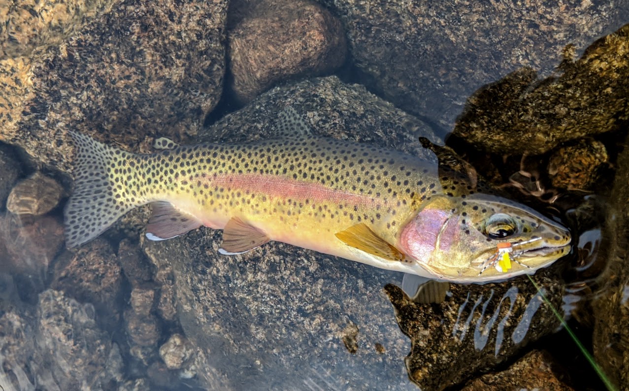
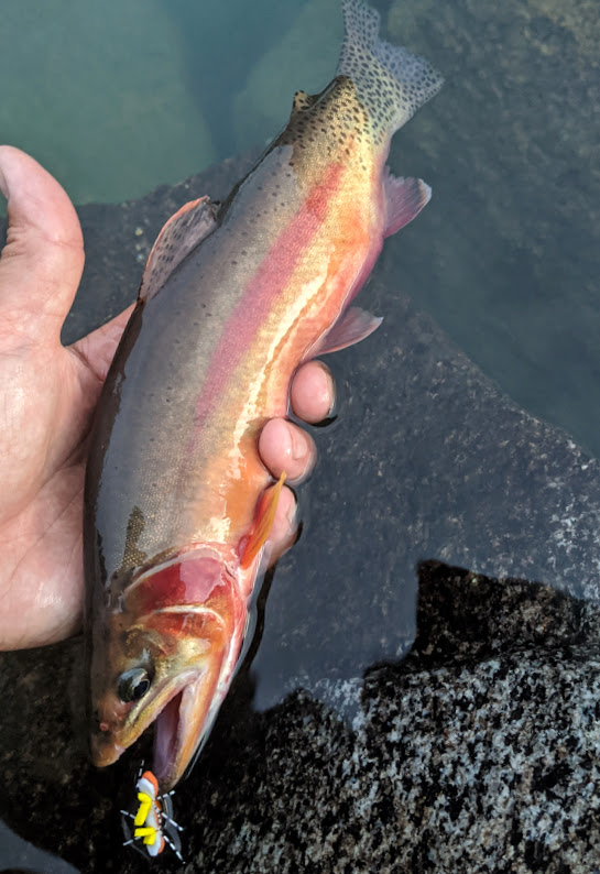
I did stop for a hot second to scout for trout in one of the lakes lower down in the chain. This one taunted me, and because I couldn't catch him, I snapped a photo instead.

Darwin Bench was as lovely as I remembered. My wife acknowledged that this morning was even more beautiful than the afternoon before. Success again!

Upon reaching the two tarns on the west side of Darwin Bench, we turned the corner and began our traverse west along the benches on the long south ridge of Mt. Goethe. This is a relatively straightforward traverse, but if one does not do their micro route-finding intelligently, one can end up going up and down and up and down and up and down. I was relieved when I realized that my wife found it entertaining to enter into a friendly competition to determine who was better at identifying the paths that afforded easy passage with the least amount of up and down. It turns out that neither of us are very good at this, but it helped to pass the time and keep spirits light. It rained a bit in the late morning, but luckily only a bit.

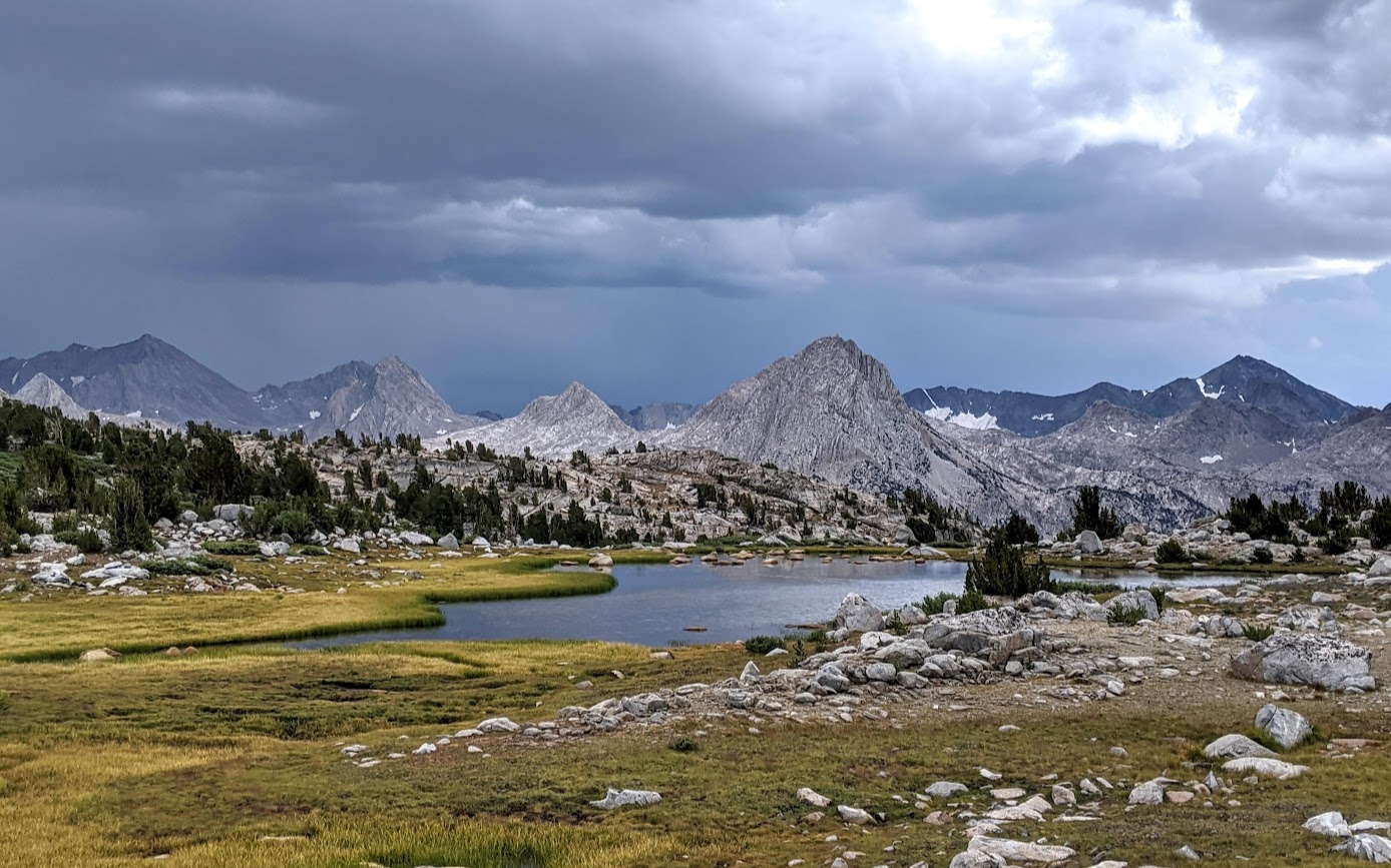
The view looking back southeast across Evolution Valley toward Evolution Basin:

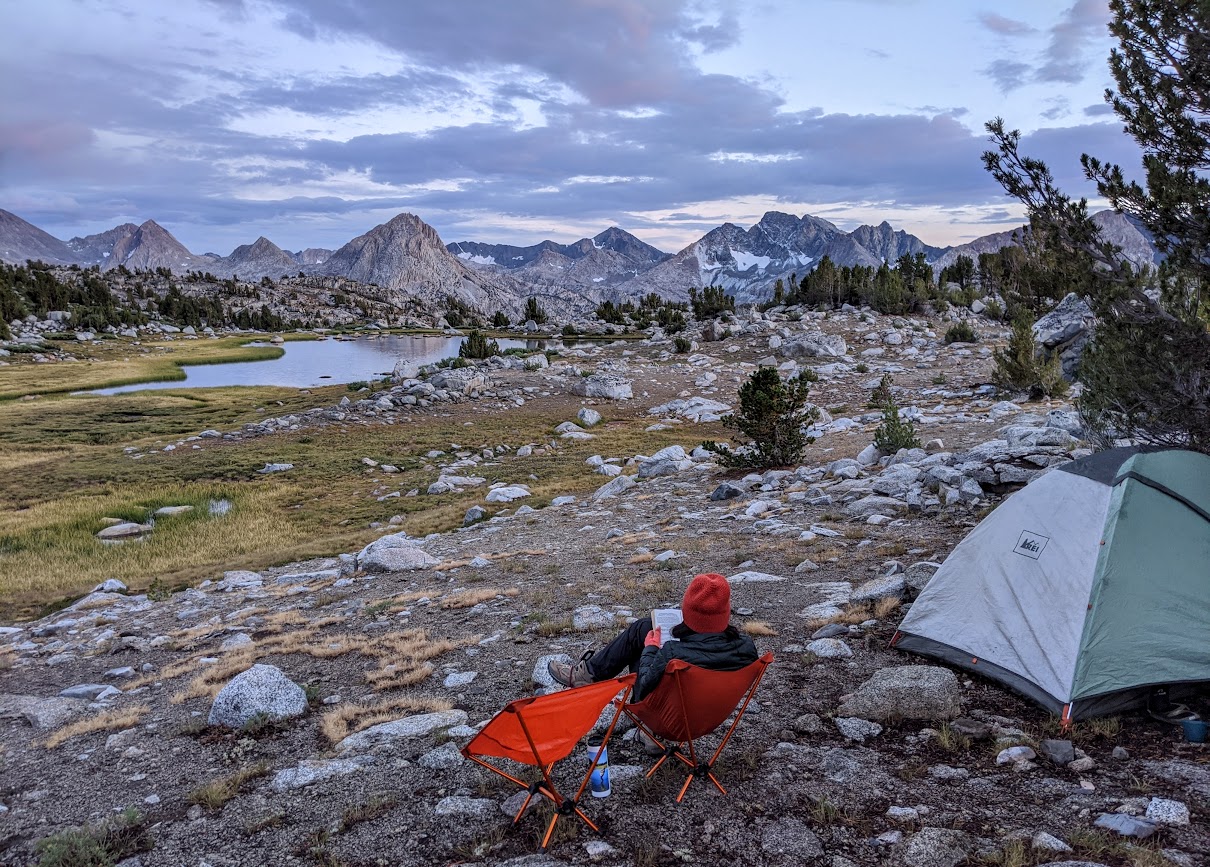
Eventually we arrived at the large unnamed lake at 11,092 (11,106 on older maps). The low bluff to the southeast had a few nice, protected campsites with views south toward McGee Canyon. I had time to fish for a while before the onset of the daily afternoon thunderstorm.

However, once the rain did arrive, it persevered through cocktail hour AND dinner time.We cooked black bean soup with cous cous, dehydrated mushrooms, and bacon bits under the tent vestibule.

Once the rain finally stopped, we clambered back outside to enjoy the last bit of daylight.
This was a particularly scenic view with the changing clouds causing first one distant peak and then another to light up with the last bit of sunlight:
Sunset over 11092:

Day 3:
On Monday morning, we packed up and I fished for a bit before looming clouds forced our hand and we decided to get out while the getting was still dry. We only had a handful of miles to travel, but this was the part of the itinerary that covered new territory for me so I wanted to leave plenty of time just in case it took longer than anticipated.


We followed the outlet creek of Lake 11092 southwest down to a pleasant little meadow and then walked along the meadow until the gradient began to steepen. From there, we hooked up with the use trail heading southeast down to McClure Meadow just west of the ranger station. This was an expedient route that got us from 11092 to the JMT in under an hour. We followed the JMT southbound for a mile and a half, only running into two other backpackers, and then exited the trail at the head of Colby Meadow. We crossed Evolution Creek (only knee-deep where we were, but cold) and picked up a use trail angling up into McGee Canyon.

We followed this path for a bit, but soon ventured off to follow a side tributary as it joined McGee Creek from the west. We followed the creek as it threaded up a forested slope, staying to the south to avoid brush and deadfall, and then walked through a nice little hanging meadow before making the final ascent southwest up to Lake 10865. This was an especially scenic lake, and like at 11092 the day before, we had it to ourselves.

Looking north over Evolution Valley:

Day 4:
Another relatively short day -- today we'd descend back down to Evolution Valley, then head back up through Darwin Bench to Darwin Canyon so that we could head out on Wednesday. After packing up, we re-traced our steps back down to McGee Creek and then crossed the creek at just over 10,000 feet so we could descend on the east side of the creek. This was mostly out of laziness, to try to avoid taking off our boots for the Evolution Creek crossing again.

The McGee Creek crossing was easy, as we found a place to hop over when it split into a few braids on some granite slabs. Then after dropping down to Evolution Creek, we found a log crossing that allowed us to reunite with the JMT with boots still on and feet still dry. (This small victory was short-lived, as the patient reader will soon discover.) We ran into more JMT hikers now, as well as a group day hiking into Evolution Basin from a camp somewhere in Evolution Valley, but once we reached the top of the switchbacks along Darwin Creek we left them behind as we headed up the use trail into Darwin Bench. Clouds loomed overhead once again.

Pausing above the lake on Darwin Bench before the final ascent into Darwin Canyon:

Back in Darwin Canyon, we scouted for a better campsite than the one we used on Night 1 but couldn't find one. So instead we returned to the same site nestled near the short connector stream between Lake #3 and Lake #4 that we had employed before. Shortly after we set up the tent, it began to rain softly. But it wasn't enough rain to dissuade me from racing up and down the chain of lakes chasing after trout, so race up and down I did.
The view over Lake #1:

Then it began -- thunder boomed, and the raindrops started hitting faster and closer together. The sound of the rain hitting the lake intensified. This was enough rain to dissuade me from fishing. I took cover amongst a stand of short, wind-stunted trees to wait it out. 5 minutes turned to 10 minutes, and 10 minutes turned to 30 minutes. A couple of bedraggled-looking backpackers with rain shells plastered to their skin and rain covers plastered to their backpacks trudged by, unaware of the creepy guy cowering in the trees eyeing them just ten feet away. I wonder how many times a large animal or even fellow human has eyed me in the same way as I walked by, unaware. Soon the water dripping from the trees above me was getting me as wet as the rain itself (I thought, wrongly), so I decided to make a run for it back to camp. Bad idea. By the time I got back, my lower half was completely soaked. Including the very boots I was so proud of not having to remove to wade across Evolution Creek earlier in the day.
But this wasn't the worst of it. My wife informed me upon my return that the flat pad we had picked for our tent had flooded. And though it hadn't come over the top of the bathtub floor yet, the tent floor was starting to dampen. We hurriedly moved the tent on top of some flat granite nearby and surveyed the scene: where our tent had been perched there was now a small pond 8" deep, with rain continuing to pour down.
There was an existing small drainage culvert that had been dug by prior residents of the campsite, but it was only producing a small trickle at present so it was like trying to drain a bathtub through a straw. My wife brings this lightweight gardening trowel on backpacking trips for the express purpose of digging cat holes, and I tease her for it at every chance I get. But after this sopping wet, cold afternoon I would tease no more. Now, that trowel was the most valuable possession we owned. We set to work digging the drainage culvert out, moving several of the large rocks that campers had stacked up for wind protection (sorry, future campsite denizens), and turning it into a proper drainage ditch. We excavated earth with alacrity, deepening and widening both the drainage trench as well as creating a new trench down the middle of the erstwhile tent site so as to speed the removal of the dozens of gallons of rainwater that had accumulated. We even dragged some rocks over to help displace water faster, though this probably wasn't at all helpful.
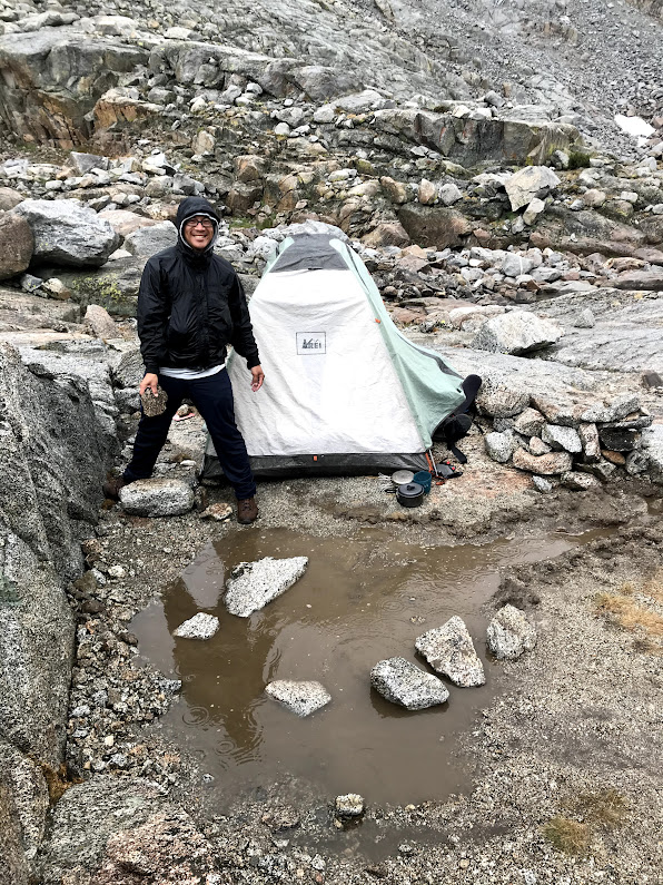
Soon the rain subsided, and we were granted a bit of a reprieve. Shortly after that, we completed our task in diverting nearly all of the water away from the tent pad. Success! In a very pitiful sort of way. We cheered our victory with hot cocoa, and then laughed like crazy people at the ridiculousness when the sun came out shortly afterward. We set to pulling out all of our wet clothes and gear and drying them out on the rocks, and luckily the sun lasted long enough to get everything dry again. By the evening, dark clouds still loomed worryingly overhead but the skies were mostly clear to the west. I enjoyed the opportunity to fish a bit and even caught a little gold.


Day 5:
Wednesday, 8/19 was our exit day. There was nothing left to do but trace our steps from Day 1 and get back to the car, which would convey us to the large, juicy, messy, and overall perfect burgers waiting for us at Mountain Rambler Brewery in Bishop. The day remained rain-free until we had reached the North Lake trailhead and were walking the dirt road back to the hiker parking lot, at which point the heavens opened as if to prove a point: it rains on our schedule, not yours.

Driving back home, we got our first glimpse of what the rest of California had been experiencing over the past few days. The drive west along Hwy 108 around Sonora Pass was especially eerie as the smoke shrouded everything in a dense veil of foreboding. That rain that we cursed each day had actually done a pretty good job of keeping our trip smoke-free. Who'd have thought we'd be grateful for it now?
Despite the inclement weather, something clicked on this trip -- my wife ranks this among our top backpacks, and raved about the views, the route, and the solitude. She enjoyed the talus hopping, the micro route-finding, and all of the opportunities to read in comfy camp chairs while I flailed around with a fishing rod. Even the rain didn't dampen her spirits, though it sure tried its best. Now I'm trying to figure out a suitable encore over Labor Day weekend, assuming we don't cancel due to smoke.


