This is speculation, not a report, hence a new thread...
Given the recent snowfall and likely predicted late heavy snowfall this weekend, how much will this likely push back off-trail high altitude exploration this year? High passes? Peaks? Mid-June? Mid-July? Later? I got killed by late-season soft-snow last year, twice, and do not want to repeat it.
I am also wondering about the Meet-up location and dates-
It does not concern me directly, but I also wonder about the potential PCT disruption.
Take your best shot-
2019 snow speculation as of May 16
-
CAMERONM

- Topix Expert
- Posts: 477
- Joined: Thu Jul 02, 2015 10:04 am
- Experience: Level 4 Explorer
- Location: Los Angeles
- Contact:
2019 snow speculation as of May 16
Last edited by CAMERONM on Fri May 17, 2019 6:19 am, edited 1 time in total.
-
rightstar76
- Topix Expert
- Posts: 776
- Joined: Mon Jun 26, 2006 3:22 pm
- Experience: N/A
Re: 2019 snow speculation as of May 16
I've been thinking about that as well.
The Climate Prediction Center forecast for the rest of May looks cold and wet for the High Sierra. I might have thought this would mean a delayed season until I took a look at climate scientist Daniel Swain's most recent blog entry:
If Dr. Swain is correct, the snowmelt may be rapid and high elevation hiking may not be delayed that much. Regardless, I think we're in uncharted territory and all bets are off.
The Climate Prediction Center forecast for the rest of May looks cold and wet for the High Sierra. I might have thought this would mean a delayed season until I took a look at climate scientist Daniel Swain's most recent blog entry:
Long-term implications are less clear, though, since wet springs have historically been linked toward more severe fires later in the season across much of the state (as the added moisture allows for increased vegetation growth, which inevitably dries out during California’s bone dry summers. The opposite tends to be true in the denser forests at cooler, higher elevation–where wet springs/snowy winters historically tended to keep the soil column from drying out even in late summer–but that rule of thumb has become a bit dubious as California’s climate has continued to warm).
http://weatherwest.com/archives/6784As the MJO signal slowly propagates, it will eventually move into a position unfavorable for the continuation of active weather across California. Right now, the models are hinting this could happen during the last week in May–likely setting the stage for rapid drying (and perhaps also a pretty sudden warm-up to summer-like heat).
If Dr. Swain is correct, the snowmelt may be rapid and high elevation hiking may not be delayed that much. Regardless, I think we're in uncharted territory and all bets are off.
-
Wandering Daisy
- Topix Docent
- Posts: 7051
- Joined: Sun Jan 24, 2010 8:19 pm
- Experience: N/A
- Location: Fair Oaks CA (Sacramento area)
- Contact:
Re: 2019 snow speculation as of May 16
Yup-cancel all your permits! 
-
SSSdave
- Topix Addict
- Posts: 3597
- Joined: Thu Nov 17, 2005 11:18 pm
- Experience: N/A
- Location: Silicon Valley
- Contact:
Re: 2019 snow speculation as of May 16
I've been through several big snow years over decades. It does significantly delay access to higher snow free elevations. It's not that one cannot backpack into snowy high elevations but rather I find snowy bright expanses boring, tedious, and generally unaesthetic. As for rate of snow melt, sun exposure becomes a significant factor into mid summer versus just elevation. Thus north facing and heavy forests melt out slowly and tend to remain marshy, muddy, mosquitoey all summer below higher draining slopes. By mid July there will be significant numbers of destinations below 10k that will be open for backpacking however that will throw usual itineraries into chaos because most backpackers pay little attention to elevations when they create trips but rather focus on popular lake destinations that tend to be above that in timberline and alpine zones. So the wise planner will pay close attention to topo maps staying at lower elevations below snow lines except when traveling across well used passes with a use track.
Memorial Day 2019 may be the snowiest at backpacking elevations during my lifetime. I am expecting to get over Kaiser Pass by mid June in order to backpack 6 days into the SF San Joaquin canyon staying below 8.5k but will see when they manage to dig out now that more snow has piled up. I also expect to bring back outstanding images that are going to surprise those that just race through that area not paying attention. I also hoped to go over Shepherd Pass mid August, however that now has to delay to maybe the 20th because the Rolling Stones tour date at Levi Stadium that I have a ticket for has been rescheduled for 8/18.
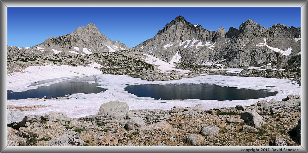
In early August 1995, a big El Nino year, 3 of us barely were able to cross Bear Creek at the 9550 JMT/PCT crossing while dozens of groups were stuck on each side. We went up into the East Fork basin and found considerable areas of snow with little greenery, lakes mostly frozen including Vee Lake, thus escaped back down to lower areas. In 2017 I had to schedule my Silver Divide trip before my the mid month Oregon road trip for the solar eclipse to a similar early August period and not unexpectedly found Grinnel Lake at 10.8k on 8/7 mostly still iced up and note it faces the sunny south without any sun blocking mid day ridges:
But by late August much had recently melted out on my Humphreys Basin trip. So where are some of these lower elevation areas? Dinkey Lakes and Emigrant Basin, western Yosemite, because it's lower elevations are heavily glaciated that tends to allow lakes at lower elevations versus Sierra Crest areas. Also further north, all the volcanic landscape into Tahoe and Desolation Wilderness. Oh but those places are not as scenic with spectacular craggy peaks! True but there is much beauty and wonder there too especially rich areas of wildflowers and creature life, if one bothers to really look. Well below 10k, Mokelumne Wilderness:

And there are other numbers of destination lakes below 9.5k in the southern Sierra if one bothers to look at topos. Yeah but I want to make loop trips and hike lots of miles each day. Don't be so rigid, loop trips are over rated, slow down and smell the flowers.
Memorial Day 2019 may be the snowiest at backpacking elevations during my lifetime. I am expecting to get over Kaiser Pass by mid June in order to backpack 6 days into the SF San Joaquin canyon staying below 8.5k but will see when they manage to dig out now that more snow has piled up. I also expect to bring back outstanding images that are going to surprise those that just race through that area not paying attention. I also hoped to go over Shepherd Pass mid August, however that now has to delay to maybe the 20th because the Rolling Stones tour date at Levi Stadium that I have a ticket for has been rescheduled for 8/18.
In early August 1995, a big El Nino year, 3 of us barely were able to cross Bear Creek at the 9550 JMT/PCT crossing while dozens of groups were stuck on each side. We went up into the East Fork basin and found considerable areas of snow with little greenery, lakes mostly frozen including Vee Lake, thus escaped back down to lower areas. In 2017 I had to schedule my Silver Divide trip before my the mid month Oregon road trip for the solar eclipse to a similar early August period and not unexpectedly found Grinnel Lake at 10.8k on 8/7 mostly still iced up and note it faces the sunny south without any sun blocking mid day ridges:
But by late August much had recently melted out on my Humphreys Basin trip. So where are some of these lower elevation areas? Dinkey Lakes and Emigrant Basin, western Yosemite, because it's lower elevations are heavily glaciated that tends to allow lakes at lower elevations versus Sierra Crest areas. Also further north, all the volcanic landscape into Tahoe and Desolation Wilderness. Oh but those places are not as scenic with spectacular craggy peaks! True but there is much beauty and wonder there too especially rich areas of wildflowers and creature life, if one bothers to really look. Well below 10k, Mokelumne Wilderness:
And there are other numbers of destination lakes below 9.5k in the southern Sierra if one bothers to look at topos. Yeah but I want to make loop trips and hike lots of miles each day. Don't be so rigid, loop trips are over rated, slow down and smell the flowers.
-
frozenintime
- Topix Regular
- Posts: 338
- Joined: Tue Aug 18, 2015 8:06 pm
- Experience: N/A
Re: 2019 snow speculation as of May 16
what do you all make of this graph (http://cdec.water.ca.gov/reportapp/java ... OT_SWC.pdf) which seems to show this high snow year melting so fast that it's approaching the *average* snow water content for this time of year? (ignoring the slight increase with the current storm.)
has it been significantly warmer at high elevation this spring? i haven't read anything to that effect.
has it been significantly warmer at high elevation this spring? i haven't read anything to that effect.
-
markskor

- Founding Member - RIP
- Posts: 2442
- Joined: Fri Oct 28, 2005 5:41 pm
- Experience: Level 4 Explorer
- Location: Crowley Lake and Tuolumne Meadows
Re: 2019 snow speculation as of May 16
Yup, If you guys all stay home, I won't have to work so hard!
Thinking less than a month to go.
Mountainman who swims with trout
-
Wandering Daisy
- Topix Docent
- Posts: 7051
- Joined: Sun Jan 24, 2010 8:19 pm
- Experience: N/A
- Location: Fair Oaks CA (Sacramento area)
- Contact:
Re: 2019 snow speculation as of May 16
A leveling off of melt for a week or so during the last half of May is quite common for previous high snow years. This current and forecast storm for this weekend looks like it will bump us from almost average melt curve onto the melt curve of 2017. Still a earlier melt than 2011.
We were on a southwestern Utah-Colorado tour for two weeks so was not checking weather. I think the weather before this current storm system was warmer than normal.
The snow stations used in this graphing of averages are meant to capture the elevations that produce the water that will flow into the reservoirs, and not a lot of higher elevation data points. It also primarily represents the west side of the Sierra because the east side watersheds are relatively small compared to the west side watersheds. The value is that if the melt is similar to, say 2017, we can then look at what we did then and how much snow there was. Certainly not perfect, but gives an idea.
I am more inclined to put up with the snow and go higher and higher to out-run the mosquitoes. I also do not find snowy terrain stark or ugly, quite the contrary, although it does not photograph as well as the lush wildflowers. The actual melt zone of soft slushy snow is harder to deal with than solid hard snow. I have a lot of experience on snow. I am hoping that those scared of snow will cancel so I can get some prime permit slots. I am a lot more concerned about stream crossings. I plan carefully to avoid known difficult crossings.
-
Gazelle
- Topix Expert
- Posts: 469
- Joined: Sat Mar 24, 2012 11:01 am
- Experience: Level 4 Explorer
- Location: almost holbrook junction nv
Re: 2019 snow speculation as of May 16
personally I like having the snow! Just plan river crossings! most of mine are high elevation once I get there. Still planning Ionian basin mid july. At My house by Donner Summit it is melting quickly, but is not 12000 ft. I have been out backcountry skiing instead of hiking. People just need to be smart and be able to adjust their plans. Have been watching the PCT stuff and am quite scared by the lack of knowledge!
Kristine
Kristine
The woman who follows the crowd will usually go no further than the crowd. The woman who walks alone is likely to find herself in places no one has ever been before. Albert Einstein
-
rightstar76
- Topix Expert
- Posts: 776
- Joined: Mon Jun 26, 2006 3:22 pm
- Experience: N/A
Re: 2019 snow speculation as of May 16
Dave, I am looking forward to seeing pictures of your June trip. Nice wildflower photo of Mokelumne Wilderness!
-
esrice
- Topix Novice
- Posts: 12
- Joined: Fri Nov 30, 2018 4:19 pm
- Experience: Level 3 Backpacker
Re: 2019 snow speculation as of May 16
This is probably way too specific and speculative of a question, but what do people think the chances are of the snow line in the central Sierra getting above, say, 8,500ft within the next three weeks? I've got a trip planned starting June 8 in the 6,000-9,000ft range. I don't mind crossing the occasional snowfield but am not looking to bring snowshoes and an axe. Should I just give up and find an alternate plan, or might there actually be enough melt between now and then to make this doable?
Who is online
Users browsing this forum: Google Adsense [Bot] and 5 guests