Grab your bear can or camp chair, kick your feet up and chew the fat about anything Sierra Nevada related that doesn't quite fit in any of the other forums. Within reason, (and the HST rules and guidelines) this is also an anything goes forum. Tell stories, discuss wilderness issues, music, or whatever else the High Sierra stirs up in your mind.
Hi everyone. This thread is for polite discussion. Discourse, sharing articles and differing viewpoints, agreeing to disagree, that's what makes HST a great forum. Foodfights don't. Let's be kind to one another.
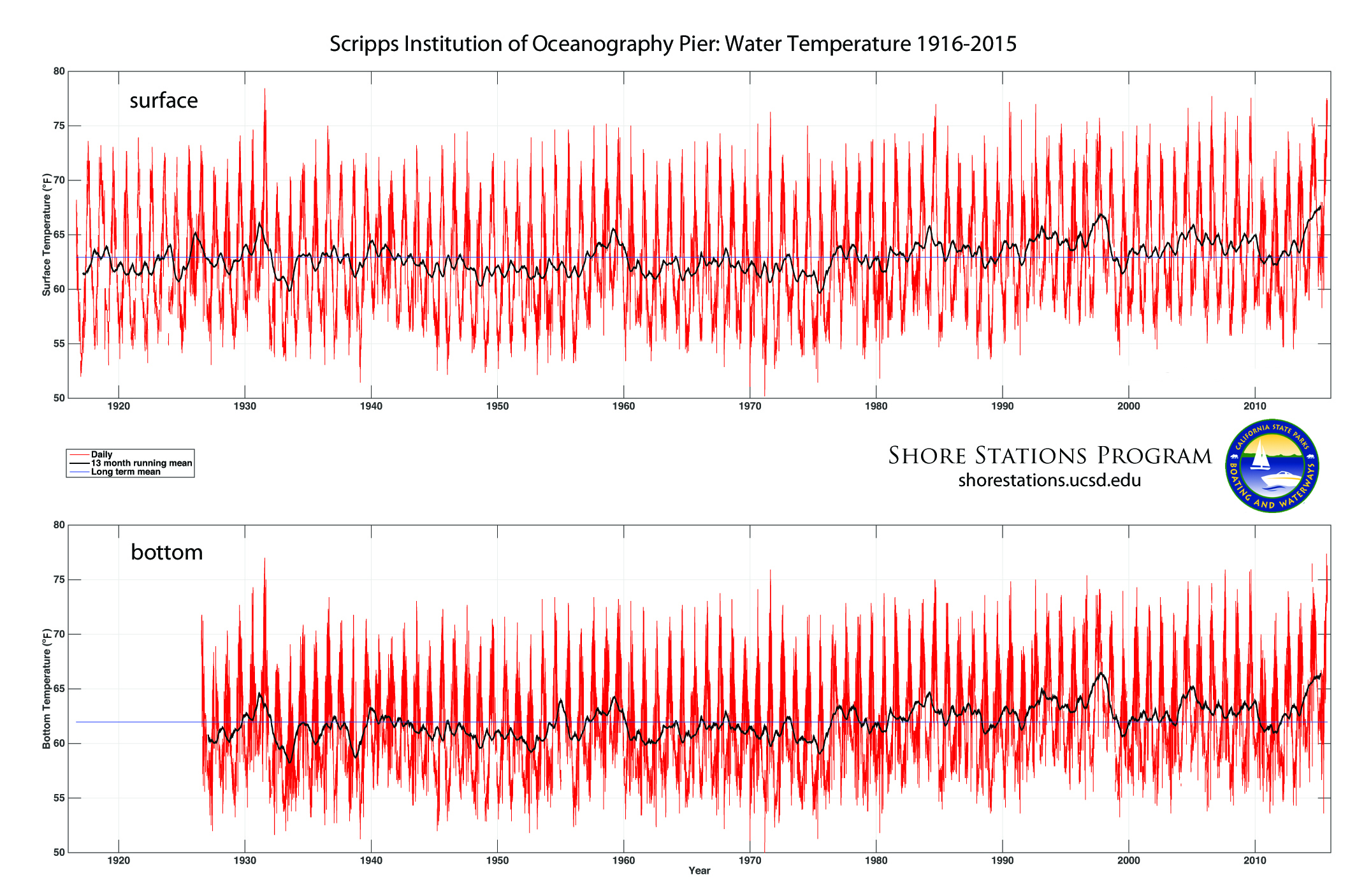
The sea surface temperatures (sst) off the southern portion of the California coast have broken an all time record (after breaking an all time record a week ago): https://mashable.com/2018/08/15/record- ... alifornia/
The heat and humidity have been abnormal in the southern half of our state, while the fires burn in the northern portion. I'm barely getting used to this new normal.
Looks like Yellowfin tuna are within striking range of the overnight boats at H & M. I'm surprised to find no Dorado in the counts, but I did see one boat with zero anglers catch 73 yellowfin. Wonder how that works?
If you don't know where you're going, then any path will get you there.
It's too bad we don't see a 4 month mean there. I remember in the early '80's, when we had a particularly strong El Nino, that the exotics (blue fin, big eye, yellow fin and yellow tail) traveled extremely far North of their usual pattern. Small Yellowtail (5 to 6 lbs) were tail finning the intake buoy in Redondo Harbor and Dorado/yellowtail were being hammered from under kelp patties in the Catalina channel. That was a destructive period for Kelp. Most healthy kelp beds that normally grow around Palos Verdes were decimated because of the warm water. When Lisa and I were hiking PV last year, the beds were well established. I noticed particularly healthy beds on the reef I used to dive regularly at Christmas tree cove. It was obvious where the outer reef was, but in the '80's, you had to know where it was because of the lack of kelp. BTW, Christmas tree cove is no longer called that. I don't recall what it is called now, but if I did, I would not spot burn it. It's sustained too much damage from over fishing as it is.
If you don't know where you're going, then any path will get you there.
I've been monitoring the below map recently with an interest of making a beach road trip down south. Love getting into surf if not chilly.. North of Point Conception ocean temps have stubbornly remained below average all summer with many foggy days that the cold ocean temps cause. I live 25 miles from Santa Cruz and enjoy an occasional sand and beach day but not so this year. Recent national news has been off La Jolla near San Diego where yesterday a couple buoys recorded 81F surface temps. Water temps will continue to rise over next 2 or 3 weeks.
Need to figure out how to make a short trip of just a few days on the cheap living inside my Forester without getting nailed by usual high lodging rates even for cheapest Motel 6 motels. Map shows I really only need to drive down as far as Santa Barbara where the water is a reasonable 72F that is 7F above normal thus significantly less chilly. Cheapest motels there are expensive at $100+ while a bit south in Oxnard are ~$60 to $70. 30 miles north on US101 is the free Gaviota overnight rest area. Leadbetter Beach in SB has public outdoor showers. Need to do some more research.


