Shepherd Pass inquiry
-
bobby49

- Topix Fanatic
- Posts: 1274
- Joined: Sat Nov 11, 2017 4:17 pm
- Experience: Level 4 Explorer
Shepherd Pass inquiry
Does anybody have any up-to-date trail information about Shepherd Pass? Specifically, I am interested in whether there is much of a snow field on the headwall near the top. I could bring microspikes and an ice axe if necessary, but I would much prefer to leave that weight behind. I expect to be there in the fourth week of July. I've been over most of the east side passes, but most of them are not quite so steep at the top so that snow is held.
-
rightstar76
- Topix Expert
- Posts: 776
- Joined: Mon Jun 26, 2006 3:22 pm
- Experience: N/A
Re: Shepherd Pass inquiry
Bobby49, I saw this on Shepherd Pass on another forum. I hope it helps.
http://www.whitneyportalstore.com/forum ... Post102663
http://www.whitneyportalstore.com/forum ... Post102663
-
bobby49
- Topix Fanatic
- Posts: 1274
- Joined: Sat Nov 11, 2017 4:17 pm
- Experience: Level 4 Explorer
Re: Shepherd Pass inquiry
That is certainly on-subject, but I have no idea where the Shepherd Pass fire is located. There isn't much to burn right at Shepherd Pass.
-
bobby49
- Topix Fanatic
- Posts: 1274
- Joined: Sat Nov 11, 2017 4:17 pm
- Experience: Level 4 Explorer
Re: Shepherd Pass inquiry
Now I see that the fire is between the Shepherd Pass Trailhead and Whitney Portal, down low in the access roads. Hopefully Cal Fire will knock that out quickly.
-
maverick

- Forums Moderator

- Posts: 12092
- Joined: Thu Apr 06, 2006 5:54 pm
- Experience: Level 4 Explorer
Re: Shepherd Pass inquiry
Shepherd Pass Trail is closed on till further notice.
http://www.highsierratopix.com/communit ... 73#p137573
PS Will re-open this evening.
http://www.highsierratopix.com/communit ... 73#p137573
PS Will re-open this evening.
Professional Sierra Landscape Photographer
I don't give out specific route information, my belief is that it takes away from the whole adventure spirit of a trip, if you need every inch planned out, you'll have to get that from someone else.
Have a safer backcountry experience by using the HST ReConn Form 2.0, named after Larry Conn, a HST member: http://reconn.org
-
bobby49
- Topix Fanatic
- Posts: 1274
- Joined: Sat Nov 11, 2017 4:17 pm
- Experience: Level 4 Explorer
Re: Shepherd Pass inquiry
From my view from Google Earth, Shepherd Pass is difficult to see. If you are in Independence or closer to the trailhead, it is blocked from view. If you got northeast of Independence, maybe toward Mazourka Canyon, then it might be visible.
Before I start up there, I might want to look at the snow patch at the pass with a telescope.
Before I start up there, I might want to look at the snow patch at the pass with a telescope.
-
ironmike
- Topix Regular
- Posts: 168
- Joined: Sun Oct 30, 2005 8:14 pm
- Experience: Level 4 Explorer
- Location: California
Re: Shepherd Pass inquiry
The pass is definitely visible from south of Independence on the highwaybobby49 wrote:From my view from Google Earth, Shepherd Pass is difficult to see. If you are in Independence or closer to the trailhead, it is blocked from view. If you got northeast of Independence, maybe toward Mazourka Canyon, then it might be visible.
Before I start up there, I might want to look at the snow patch at the pass with a telescope.
-
bobby49
- Topix Fanatic
- Posts: 1274
- Joined: Sat Nov 11, 2017 4:17 pm
- Experience: Level 4 Explorer
Re: Shepherd Pass inquiry
Are you looking up Symmes Creek, or looking up Shepherd Creek? From where is this visible? Along 395? It seems like if you are in Independence, you can't see over the ridge between Symmes Creek and Shepherd Creek. If you are too far south, then you can't "see around the corner" of the curve of Shepherd Creek.
-
ironmike
- Topix Regular
- Posts: 168
- Joined: Sun Oct 30, 2005 8:14 pm
- Experience: Level 4 Explorer
- Location: California
Re: Shepherd Pass inquiry
Slightly south of Independence but north of Manzanar on 395, there is a brief moment where you can peer over the ridge separating the Symmes and Shepherd Creek drainages and see the actual pass.
The long lingering snow field below the east side of the pass is an easy to spot visual cue.
The long lingering snow field below the east side of the pass is an easy to spot visual cue.
-
DiamondEyedJack

- Topix Acquainted
- Posts: 22
- Joined: Thu Jul 27, 2017 2:54 pm
- Experience: Level 3 Backpacker
- Location: Reno
Re: Shepherd Pass inquiry
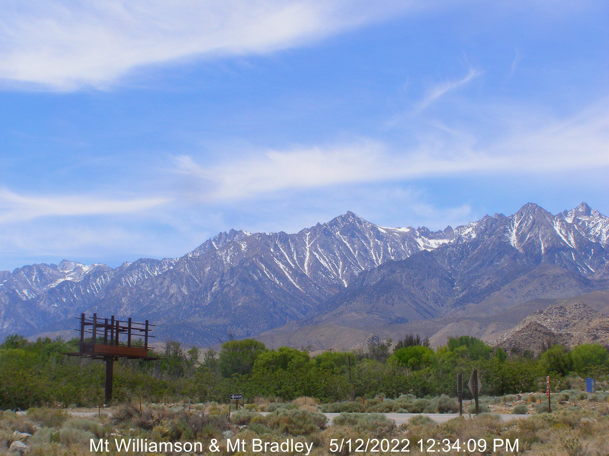
You can see the east-side of the pass here, off WhitneyZone.com. Zoom-in to the area under Tyndall, a few pixels will show you the area containing the steep switchbacks just below the pass.
http://www.whitneyzone.com/webcam/will/willi.jpg
http://www.whitneyzone.com/webcam/will/willi.jpg
Krazy Kat peeking through a lace bandana, like a one-eyed Cheshire, like a diamond-eyed jack
Who is online
Users browsing this forum: Google Adsense [Bot] and 19 guests