Recommendations for ~5 day backpacking in Sierra?
-
sha256

- Topix Newbie
- Posts: 3
- Joined: Sat Jun 17, 2017 6:00 pm
- Experience: Level 1 Hiker
Recommendations for ~5 day backpacking in Sierra?
I have a Rae Lakes Loop (Clockwise) permit to hike June 27-July 2. Considering the trail conditions, I have been strongly recommended to cancel it. So I am looking for alternatives. Are there any 4-6 day backpacking that you would recommend in Sierra for <50 miles to go in a week? I am 30 and in a decent fit. I have done the 3 day / 30 mile trips into Grand Canyon a few times and have been doing day hikes regularly. My buddy will be coming with me and he has a similar experience. Thanks!
-
AlmostThere
- Topix Addict
- Posts: 2724
- Joined: Wed Jun 24, 2009 4:38 pm
- Experience: Level 4 Explorer
Re: Recommendations for ~5 day backpacking in Sierra?
The conditions elsewhere in the high Sierra will be the same... snow above a certain elevation, particularly on north facing slopes, etc. high melt swollen dangerous streams you should not cross... move plan to September.
-
balzaccom
- Topix Addict
- Posts: 3114
- Joined: Wed Dec 17, 2008 9:22 pm
- Experience: N/A
Re: Recommendations for ~5 day backpacking in Sierra?
Trying this again with new links!
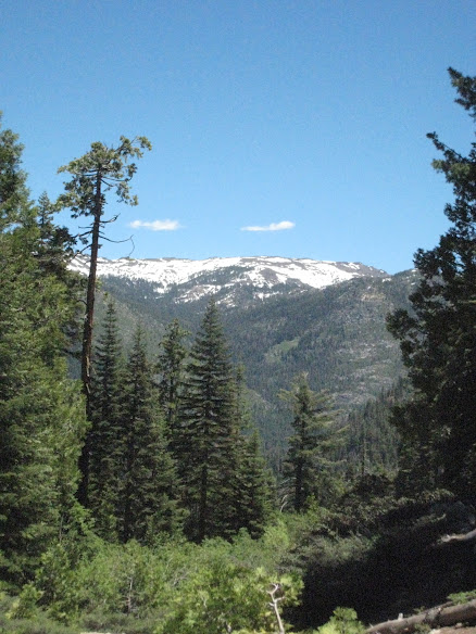
M was feeling a bit under the weather this past weekend, so we tabled plans to go backpacking. Instead, we found a nice local trail in the Stanislaus Forest below Kennedy Meadows, and took off on a day hike. It was warm (it was hot everywhere else, but we were up about 7,000 feet, so it was a bit cooler) the sky was blue, and the scenery was a treat.
we hiked up a few miles, had lunch, and then wandered around in the forest a bit before we headed back to the car. On the way, we were accompanied by at least a score of swallowtail butterflies. We even got one to sit still enough to get a good photo:

And once back at the car, we couldn't resist going up to Sonora Pass to see exactly how much snow is up there.

A lot. This is about 9,000 feet, and you can see that snow covers just about everything but the most southerly facing slopes. People were snowboarding and snowmobiling along the road here. That should give you some idea of what kinds of conditions you'll find if you start hiking anytime soon...

And by the way, this is the Stanislaus River at full flood stage. Amazing. Yes, that is solid whitewater.
M was feeling a bit under the weather this past weekend, so we tabled plans to go backpacking. Instead, we found a nice local trail in the Stanislaus Forest below Kennedy Meadows, and took off on a day hike. It was warm (it was hot everywhere else, but we were up about 7,000 feet, so it was a bit cooler) the sky was blue, and the scenery was a treat.
we hiked up a few miles, had lunch, and then wandered around in the forest a bit before we headed back to the car. On the way, we were accompanied by at least a score of swallowtail butterflies. We even got one to sit still enough to get a good photo:
And once back at the car, we couldn't resist going up to Sonora Pass to see exactly how much snow is up there.
A lot. This is about 9,000 feet, and you can see that snow covers just about everything but the most southerly facing slopes. People were snowboarding and snowmobiling along the road here. That should give you some idea of what kinds of conditions you'll find if you start hiking anytime soon...
And by the way, this is the Stanislaus River at full flood stage. Amazing. Yes, that is solid whitewater.
Last edited by balzaccom on Mon Jun 19, 2017 1:03 pm, edited 1 time in total.
Check our our website: http://www.backpackthesierra.com/
Or just read a good mystery novel set in the Sierra; https://www.amazon.com/Danger-Falling-R ... 0984884963
Or just read a good mystery novel set in the Sierra; https://www.amazon.com/Danger-Falling-R ... 0984884963
-
Flamingo

- Topix Regular
- Posts: 392
- Joined: Tue Mar 29, 2011 12:18 pm
- Experience: Level 4 Explorer
- Location: West Oakland, California
- Contact:
Re: Recommendations for ~5 day backpacking in Sierra?
@balzaccom -- Your photos are not loading for me. (Maybe it's just me, though). I'm dying to see your photos from Kennedy Meadows and Sonora Pass. Can you fix?
-
maverick

- Forums Moderator

- Posts: 12108
- Joined: Thu Apr 06, 2006 5:54 pm
- Experience: Level 4 Explorer
Re: Recommendations for ~5 day backpacking in Sierra?
Must be on your end Flamingo, showing up fine on my end. 
Professional Sierra Landscape Photographer
I don't give out specific route information, my belief is that it takes away from the whole adventure spirit of a trip, if you need every inch planned out, you'll have to get that from someone else.
Have a safer backcountry experience by using the HST ReConn Form 2.0, named after Larry Conn, a HST member: http://reconn.org
-
balzaccom
- Topix Addict
- Posts: 3114
- Joined: Wed Dec 17, 2008 9:22 pm
- Experience: N/A
Re: Recommendations for ~5 day backpacking in Sierra?
Check our our website: http://www.backpackthesierra.com/
Or just read a good mystery novel set in the Sierra; https://www.amazon.com/Danger-Falling-R ... 0984884963
Or just read a good mystery novel set in the Sierra; https://www.amazon.com/Danger-Falling-R ... 0984884963
-
AlmostThere
- Topix Addict
- Posts: 2724
- Joined: Wed Jun 24, 2009 4:38 pm
- Experience: Level 4 Explorer
Re: Recommendations for ~5 day backpacking in Sierra?
I saw them both times just fine.
-
wildhiker

- Topix Fanatic
- Posts: 1215
- Joined: Tue Jul 26, 2011 4:44 pm
- Experience: Level 4 Explorer
- Location: Palo Alto, CA
- Contact:
Re: Recommendations for ~5 day backpacking in Sierra?
So far, no one has provided any suggestions for the OP, who did take the group's advice to cancel his planned Rae Lakes Loop discussed in his previous post.
I'm less familiar with the Sequoia/Kings Canyon alternatives, but the trip report on the High Sierra trail just posted by earth_materials (http://highsierratopix.com/community/vi ... =1&t=16021) sounds like a possible alternative. It would be in-and-out, with the possibility of exploring up the HST beyond Hamilton Lake or up Lone Pine Creek until you hit the snow. Or you could possibly explore lower down from Bearpaw Meadow to Redwood Meadow to see a wilderness grove of giant sequoia trees. You could also check with the Sequoia Park rangers whether the Panther Gap trail out of Wolverton is passable. If so, and if the shuttle is running already from Giant Forest to Lodgepole, you could add a little bit of different country (and maybe less competition for the wilderness permit) by going in from Wolverton over Panther Gap (amazing views) down to the HST at Mehrten Creek, and then on the way back, stay on the HST all the way to Crescent Meadows and shuttle back to Wolverton (ask the driver to drop you off at the road junction as he heads from the General Sherman parking to Lodgepole and just walk about 1 mile up the road to Wolverton).
-Phil
-
AlmostThere
- Topix Addict
- Posts: 2724
- Joined: Wed Jun 24, 2009 4:38 pm
- Experience: Level 4 Explorer
Re: Recommendations for ~5 day backpacking in Sierra?
I could have sworn I posted here again.
Mineral King is open, and with the usual caveat about snowmelt runoff - there aren't many creeks that are typically huge around, though you cross outlet streams with frequency. a couple of loops out there that should be workable barring any uncrossable streams.... Or just go up toward Eagle or Mosquito lakes and spend the time wandering around.
Mineral King is open, and with the usual caveat about snowmelt runoff - there aren't many creeks that are typically huge around, though you cross outlet streams with frequency. a couple of loops out there that should be workable barring any uncrossable streams.... Or just go up toward Eagle or Mosquito lakes and spend the time wandering around.
-
maverick
- Forums Moderator
- Posts: 12108
- Joined: Thu Apr 06, 2006 5:54 pm
- Experience: Level 4 Explorer
Re: Recommendations for ~5 day backpacking in Sierra?
Suggested a trip to Hamilton Lake in the OP's previous thread.So far, no one has provided any suggestions for the OP, who did take the group's advice to cancel his planned Rae Lakes Loop discussed in his previous post.
Professional Sierra Landscape Photographer
I don't give out specific route information, my belief is that it takes away from the whole adventure spirit of a trip, if you need every inch planned out, you'll have to get that from someone else.
Have a safer backcountry experience by using the HST ReConn Form 2.0, named after Larry Conn, a HST member: http://reconn.org
I don't give out specific route information, my belief is that it takes away from the whole adventure spirit of a trip, if you need every inch planned out, you'll have to get that from someone else.
Have a safer backcountry experience by using the HST ReConn Form 2.0, named after Larry Conn, a HST member: http://reconn.org
Who is online
Users browsing this forum: Tehol and 31 guests