Summit Lake TR: 5/27-5/30
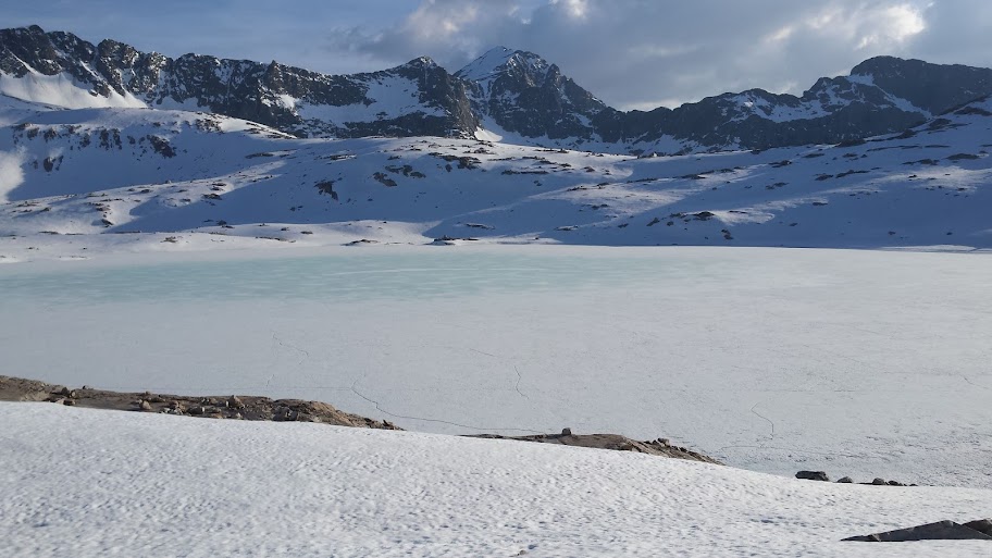
Hiked out of Shake Camp on Friday evening and got about 3 miles in before making camp. Saturday: saw some snow around 7500', lots of snow drifts around 8000-8500 on East, West & North facing slopes. At 9000', lots of deeper snow banks. At 9400', snow was 2-6' deep depending on location. Summit lake was 75% iced over with only around the shore areas open water. Tried to make it to Maggie lakes but with the trail junction sign for windy gap only 1' above the snow, we returned back to Summit lake and found the only camp spot near the lake that was not wet. Sunday: like partially froze back up but quickly melted by 9am. Too many hikers up there (+20) to stay, so we headed back down to the Tule River. Snow was melting fast on the way down and with these hot temps, the snow is going to go fast.
2016 Backcountry Conditions Reports
-
Snowtrout

- Topix Regular
- Posts: 308
- Joined: Mon Feb 18, 2013 10:06 pm
- Experience: Level 3 Backpacker
- Location: Fresno, CA
Summit Lake 5/27-5/30
Last edited by maverick on Thu Jun 02, 2016 10:03 am, edited 1 time in total.
Reason: subject matter
Reason: subject matter
-
Shawn
- Topix Fanatic
- Posts: 1072
- Joined: Sat Nov 12, 2005 9:56 pm
- Experience: Level 4 Explorer
Treasure Lakes June 3, 2016
Route taken:
Did a quick day hike to Treasure Lakes out of South Lake above Bishop. The Treasure Lakes "trail" was in dismal condition, the upper third of my route was ad hoc due to snow.
Difficult section encountered:
Due to very warm temps, it was a post-hole horror show on the upper elevation on approach to the lakes.
Special equipment needed/used:
Hiking poles helped with the soft snow / post-hole extraction tools.
Possible alternative routes:
I just made my own path when I encountered continuous snow. It is melting fast so it shouldn't be an issue for much longer.
Note: On my way down I encountered three fisherman that lost the trail and seemed, um, significantly delayed in a forested area no where near the trail. I gave them an extra map I had and provided some instructions to get them back on course. If you are not comfortable navigating off trail, and the trail unexpectedly disappears due to snow, perhaps the best choice is to turn around and try another day.
You do not have the required permissions to view the files attached to this post.
-
Wandering Daisy
- Topix Docent
- Posts: 7051
- Joined: Sun Jan 24, 2010 8:19 pm
- Experience: N/A
- Location: Fair Oaks CA (Sacramento area)
- Contact:
Emigrant-N Yosemite, May 30-June 4
Road to Shingle Springs TH is in good shape.
Kibby Ridge trail, in better shape than 2009, but new deadfall and overgrown sections. Several wet bogs, but mostly quite dry.
North facing slope down to the unnamed lakes west of Mecur Peak melting snow- some 3-foot drifts, LOTS of water, every topographic indentation a pond.
Little or no snow on route: Styx Pass - Boundary Lake - Little Bear Lake - Spotted Fawn Lake- Flora Lake - Barrett Lakes - Many Island Lake.
Day-hike to Inferno Lakes - pretty solid snow on north facing slopes, no snow on south facing slopes.
A majority of the watershed of these lakes have already melted, so lakes are high and full, but creeks are reasonable- wade to cross but not deep.
What amazed me, was how warm the water was in the lakes and small creeks.
On the way out I dropped down to Lord Meadow, Cherry Creek is HUGE! and still icy cold.
All week it was HOT! The snow is going fast at this elevation (7000-8000 feet). A few snow banks below Styx Pass were totally gone on the way out. I doubt it got below 50-60 degrees at night.
Wildflowers just beginning to bloom, the best is yet to come. Willows getting buds.
The road up to Cherry Lake really shows the devastation from the Rim Fire. Among all the burn, this year's wildflowers are in full bloom.
-
Vaca Russ

- Topix Expert
- Posts: 809
- Joined: Mon Aug 16, 2010 3:12 pm
- Experience: Level 4 Explorer
- Location: The Nut Tree
Deso High Country June 2-3
I hiked into and camped at the Dicks Lake outlet. The next morning I climbed Dicks Peak via the north face.
Northern Deso is completely snow free.
Susie is half ice free, Half Moon is starting to clear.
Pyramid, Jacks and Agassiz still hold plenty of snow.
Dicks and Fontanillis are frozen solid...The Velma's are clear.
Last year WD asked about the pass above and between Island and Clyde...here is this year's photo:
I wouldn't recommend trying to cross Dicks Pass without an ice ax and crampons.
Please see a full report here:
viewtopic.php?f=14&t=14460
Thanks,
-Russ
You do not have the required permissions to view the files attached to this post.
Last edited by Vaca Russ on Mon Jun 06, 2016 7:41 am, edited 1 time in total.
"...Or have you only comfort, and the lust for comfort, that stealthy thing that enters the house a guest, and then becomes a host and then a master?"
Kahil Gibran.
Kahil Gibran.
-
FeetFirst

- Topix Regular
- Posts: 309
- Joined: Fri Apr 22, 2011 11:35 am
- Experience: Level 4 Explorer
- Location: West Sacramento, CA
- Contact:
Desolation Wilderness, Echo to Aloha, June 3-4
Echo Lake TH west to far northwest end of Aloha via PCT. Trail was clear & dry till spur trail to boat taxi at upper Echo Lake. From there to intersection for Triangle Lake trail is under 2"-5" of running water. From there (Haypress Meadow) all the way to Lake Aloha basin is under multiple feet of snow. Gained the snow free shoulder up to Jabu Lake and scrambled the ridge up near Cracked Crag en route. Dropped back down to Le Conte Lake where I camped for the night. Found a dry section of the PCT which looked like it was dry all the way up towards Heather Lake.
Snow shoes not needed. Snow was consolidated and no post-holing involved, but it has been warm up there and things are changing quick. I had micro spikes, but didn't use them. Some hills required mini kick steps for good footing (trail runners). Gore-tex socks kept my feet warm & happy. Basic route finding required from Haypress Meadow west. However, most of the route was starting to get a pretty good boot track.

Echo Lakes

trail above boat taxi spur

Haypress Meadow

Jabu Lake

Crystal Range from Jabu Lake

Lake Aloha & Pyramid Peak

Lake Aloha towards Mosquito Pass

Lake Le Conte

Lake Le Conte

dry camp between Le Conte & PCT

from camp looking towards Mosquito Pass
Snow shoes not needed. Snow was consolidated and no post-holing involved, but it has been warm up there and things are changing quick. I had micro spikes, but didn't use them. Some hills required mini kick steps for good footing (trail runners). Gore-tex socks kept my feet warm & happy. Basic route finding required from Haypress Meadow west. However, most of the route was starting to get a pretty good boot track.
Echo Lakes
trail above boat taxi spur
Haypress Meadow
Jabu Lake
Crystal Range from Jabu Lake
Lake Aloha & Pyramid Peak
Lake Aloha towards Mosquito Pass
Lake Le Conte
Lake Le Conte
dry camp between Le Conte & PCT
from camp looking towards Mosquito Pass
I'm still rather convinced that you can achieve more than you've ever dreamed of if you just lower your standards.
-
Troutdog 59

- Topix Expert
- Posts: 651
- Joined: Thu Dec 23, 2010 12:11 pm
- Experience: N/A
- Location: Clovis
West side Ansel Adams Trail heads opening up 6/4
Went up sky Ranch Rd above Fresno Dome yesterday with the idea to possibly day hike to Grizzly Lake, but mostly to check the access to the Quartz Mtn trail head. Alas, we couldn't make it to either due to snow just past the 4x4 road to Iron Lakes. Looks like it should be gone in another week or so. We headed over to the Beasore Mdw Granite Creek area to explore. Granite Creek is ripping, even the East Fork, but no issues getting to Isberg or Mammoth trail heads with the exception of a pretty good bog just before the Mammoth TH. Beautiful day and nice to see the areas creeks with water.
Last edited by maverick on Fri Jun 10, 2016 1:56 pm, edited 1 time in total.
Reason: subject matter
Reason: subject matter
Once in a while you can get shown the light
In the strangest places if you look at it right.
The Grateful Dead
In the strangest places if you look at it right.
The Grateful Dead
-
RoguePhotonic

- Topix Fanatic
- Posts: 1693
- Joined: Thu Mar 24, 2011 9:52 am
- Experience: Level 4 Explorer
- Location: Bakersfield CA
- Contact:
Yosemite Creek from Tioga 6/4 6/5
Hiked down Yosemite Creek from the Tioga Road and went up Eagle Peak. Some patchy snow in the trees down to about 7500 feet.
-
Hobbes
- Topix Fanatic
- Posts: 1120
- Joined: Wed Apr 27, 2011 8:09 am
- Experience: N/A
- Location: The OC
Lamarck - Evo Valley 6/1
Lamarck 6/1 (Note the beautiful ski line to the right. Way too steep to ascend.)

Evo 6/1

Towards Wanda 6/1

Wanda from Muir 6/2 6:45am *

* Our goal for night of 6/1 was the hut, but we completely bonked and camped here:
We only saw two people on 6/1 - a pair of brothers hiking the PCT just exiting Evo around 4pm. They said 90% had skipped the Sierra; they were so sick of the snow they didn't care if I took a photo for them together. (Exhaustion does funny things - their response "What's there to a take a photo of? It's just more snow".) We had been in snow for 24 hours already, and would only spend a few hours below the 10.7k snowline over the next few days ourselves.
Evo 6/1
Towards Wanda 6/1
Wanda from Muir 6/2 6:45am *
* Our goal for night of 6/1 was the hut, but we completely bonked and camped here:
We only saw two people on 6/1 - a pair of brothers hiking the PCT just exiting Evo around 4pm. They said 90% had skipped the Sierra; they were so sick of the snow they didn't care if I took a photo for them together. (Exhaustion does funny things - their response "What's there to a take a photo of? It's just more snow".) We had been in snow for 24 hours already, and would only spend a few hours below the 10.7k snowline over the next few days ourselves.
Last edited by maverick on Fri Jun 10, 2016 1:57 pm, edited 2 times in total.
Reason: subject matter
Reason: subject matter
-
Kent
- Topix Newbie
- Posts: 4
- Joined: Thu Jun 26, 2014 1:56 pm
- Experience: N/A
6/8 - 6/10 Tuolumne Mdws to Waterwheel Falls
Route taken:
Glen Aulin trail from TM to Glen Aulin & Waterwheel
Dry, snow-free trial almost the entire way. A few soggy spots/puddles & remnant snow.
Creek crossings: Delaney - mostly about ankle deep. The deepest step or two is about mid-shin (12") with stronger-moving water. If you prefer to stay dry or are with a novice who doesn't like slippery rocks or a bit of current, head upstream a bit (~50yds?) and spot to log to walk across. If you use the log, loop widely back to the trail and you'll avoid the other braids of the creek. Dingley - similar, just braided into more parts. If you wade it's just deep enough to flow over/into a boot. If you like to stay dry, go upstream and cross on first log, then through 3 more crossings, each time keep angling a little more upstream to get to the next good log. You'll finish well away from the trail, but it's an easy walk back.
The swampy area below Wildcat Point is mostly mid-shin (12") & ankle depth. Crossing the stream bed itself was two steps that were just over the knee (24"). If you're one who changes shoes to cross water, keep in mind there are 2 wet sections. Don't change until you finish both.
-
cantare

- Topix Acquainted
- Posts: 26
- Joined: Wed Aug 14, 2013 9:11 pm
- Experience: Level 3 Backpacker
6/9-6/12 Hetch-Hetchy - Laurel - Tilltill - Rancheria loop
Snow: nonexistent, save for remnant patches on ~7500' shoulder of Mt. Gibson.
Creeks: Frog Creek ford between Beehive and Laurel Lk. S shore: thigh deep, moderately strong current. Log network 100' upstream of trail may be crossed dry-footed with care & good balance. No troublesome crossings anywhere else.
Mud: Beehive Meadow now dry(ish). Tilltill Valley boggy, thru trail has long stretches of calf-deep water, river sandals very useful. Some dry campsites at base of switchbacks to Vernon Lake.
Vermin: Mosquitoes 2-3 throughout dependent on the usual shade, wind, and diurnal factors. Numerous bees. Rattlesnakes out & about on hot sun-drenched slopes (Tilltill to Rancheria switchbacks, eg.)
Who is online
Users browsing this forum: No registered users and 6 guests