R03/R01 TR: Kaweah Basin Aug 15-25, 2024
Posted: Wed Dec 18, 2024 7:32 pm
Our family embarks on an extended backpack (nearly) every summer – since 2006 - in the southern Sierra. Typically these are 9-day trips – time enough to get to a beautiful and isolated place, enjoy lay-over days to explore via dayhikes, and get back out.
Our committed group on these trips is my sisters Megan and Julia (in their 60s), daughter Trekker9 and her husband Slabwalker (early-mid 30s) and self (now 72). On occasion other family members or friends join us. This August Slabwalker & Trekker9’s friend JP came with us to make a party of six.
[Last year – 2023 – our backpack didn’t happen. I had ankle replacement surgery and Slabwalker had ACL surgery, both in June of 2023 - neither of us could hike that summer.]
Our target this year was to reach Kaweah Basin. In 2017 we attempted to get to Kaweah from the Cottonwood Pass trailhead. Our 2017 schedule called for us to get to the basin in three days. This turned out to overly ambitious for our group… at the end of 3 days we were in Junction Meadow (Kern River version) and – because of a landslide during the previous heavy winter – were facing a difficult crossing of the Kern to proceed. So that year we aborted our plan and went north to Milestone Basin instead.
This year – to increase our chances of reaching Kaweah – we extended our trip to 11 days in the backcountry. In addition we looked at other routes to get there, and some of us settled on crossing Russell-Carillon Pass from the Whitney Portal trailhead as a relatively direct route to Kaweah.
As this trip report describes, the six of us were apart for major portions of the trip – in fact we only all camped together for one night out of the ten. Some of these separations were planned, others not. Between the 6 of us we had 3 Garmin Inreach units and so could (laboriously) text one another to communicate locations and plans.
This Trip Report is primarily mine, but also including inserts from Trekker9, Slabwalker and Megan to report on events/routes for which I wasn’t present.
Overall the weather was great. There was a cold front that came through on days 9 & 10. Mosquitos were not to be seen. There was smoke/haze that came in every afternoon in the western (Kaweah/Colby) region of our trek – photos were best taken in the mornings for sharpness.
DAY 1 (August 15th)
All six of us entered the mountains on this day, but in two groups from two different trailheads. Megan and Julia began from the Cottonwood Pass trailhead. They had a packer bring in their packs to Rock Creek on that first day – thus they enjoyed hiking their first 12 miles with daypacks only, knowing that their food and gear would be waiting for them. That went well!
Trekker9, Slabwalker, JP and I began from the Whitney Portal trailhead, heading up the North Fork of Lone Pine Creek towards Russell-Carillon Pass. Our first night’s goal was Upper Boy Scout Lake – less than 3 miles of horizonal hiking, but a 3000’ climb. We four were fairly leisurely about our start – camping at Convict Lake the night before, stopping in Bishop on the drive, and beginning the hike around noon. All went well enough. 3000’ vertical feet is a tough slog with full packs. The ‘ledges’ at about 10,000’ feet elevation were a challenge – part of that challenge just to discern what was intended to be the ‘trail’ in this area.
The Ledges
Then we were up out of the steep gorge, past Lower Boy Scout Lake, across the talus, up the granite slabs to Upper BSL.
Looking East to Owens Valley
I was knackered by Lower BSL, and Slabwalker helped me transport my pack on and off up the last 1000’. I have an awesome SiL!
DAY 2
On this day Megan and Julia shouldered their packs and headed north on the PCT. They reached the Crabtree Meadow camping area, then decided to push on a little farther north to avoid the crowds and achieve a little more distance. They filled up with water and continued another ½-mile before dry camping near the trail.
Trekker9, Slabwalker, JP and I had the goal of crossing Russell-Carillon Pass and reaching Wallace Lake for this day’s hike.
In recent years Slabwalker has taken to climbing non-technical peaks near our hiking route as we proceed – he can generally do this and still easily keep up with my pace. This was a day for this strategy. After breakfast I started up the long sandy slog directly from Upper BSL.
Upper Boy Scout Lake
Trekker9 gave me a head start and then followed. Slabwalker and JP headed up the alternate route to the NW – continuing up the Upper BSL canyon and then swinging around to the N and NE under Mt Russell. Trekker9 and I made it up through the sand, then across the ‘flat’ on the top and arrived at R-C Pass just as Slabwalker and JP arrived there after Slabwalker summited Mt Russell.
Sandy slope to R-C Pass
Tulainyo Lake from R-C Pass
We snacked on top. Trekker9 and I started down the north side; Slabwalker and JP went over and summitted Mt Carillon first. I’m painfully slow on my reconstructed ankle, particularly going down on talus – I don’t have the balance/confidence to step down heavily on it yet. So T, A and J had plenty of time at the bottom waiting for me. Then off to the NW past Tulainyo Lake, over a snowbank and down to the west through the meadows, over a rim and down to Wallace Lake. Slabwalker put down his pack to summit Tunnabora Peak, JP went with him partway and then also headed west to Wallace Lake. Our goal was to camp near the mouth of the lake. JP arrived first, then Trekker9 and I staggered in, with Slabwalker following. Headaches and nausea were generally shared among us this night – elevation, and maybe having to look into the setting sun for the last hours of our hike contributed. Our appetites for dinner were minimal.
(Slabwalker addition) The route up to the high shoulder of Russell above RC has a name: "Rockwell Variation". It is a very non-dangerous but physically demanding slog, involving repeated short series of "power" steps through steepish scree to get from one stable area to another for rests.
DAY 3
On this day the six of us planned to meet at Junction Meadow (Kern River). Megan and Julia accomplished this on-trail – continuing north on the PCT/JMT, turning west at Wallace Creek and down to the Kern River.
Trekker9, Slabwalker, JP and I walked down through the Wallace Creek canyon. It’s a beautiful place for a morning stroll – over ridges with sparse forest, along the creek, across various meadows.
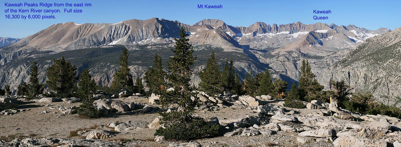
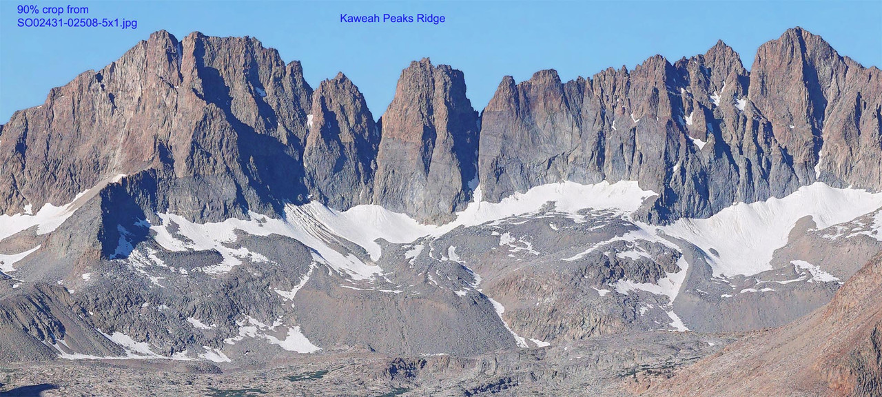
Wallace Creek Canyon, Kaweah Peaks
Meadow/Stream in Wallace Creek Canyon
Downhill, but not steeply. The map shows a use trail up through the canyon. In fact there are multiple use trails appearing and disappearing– it’s easiest if one doesn’t get hung up on trying to follow one trail in particular.
Stream Over Slab, Kaweah Peaks
At some point Slabwalker and JP pushed on ahead. Trekker9 and I reached the PCT/JMT, snacked, and continued west. After the Wright Creek crossing Trekker9 also stepped up her pace, and I eventually also reached our Junction Meadow campsite with (a little) daylight to spare.
We spend a lot of our Sierra time above treeline, so the tall pines and forested feel of this area is a nice change. Plus being low enough to have a campfire.
Trekker9: One interesting thing we saw this day, in the lightly timbered areas not far below Wallace Lake, was an obsidian arrowhead. Just a few feet away was a bit of modern human trash. A contrast of what humans leave behind them, several hundred years apart.
DAY 4
Today our hope was to all get to Kaweah Basin. This involved hiking west on the Colby Pass trail, then at an opportune time crossing the creek and angling up the slope into the Pickett Creek basin from where Kaweah Basin was accessible.
The lower section of the Colby Pass trail is not trivial. It’s a brushfield, and hasn’t been maintained as a trail for some time. Thus one is often walking through the brush while peering down into it looking for the direction of the trail.
Trail/Brush Out of Junction Meadow
Then up alongside and past the knoll that sits in the middle of the canyon, back down to the creek (where we had lunch) and on to the west on the trail – out of the brush now and easy enough to follow.
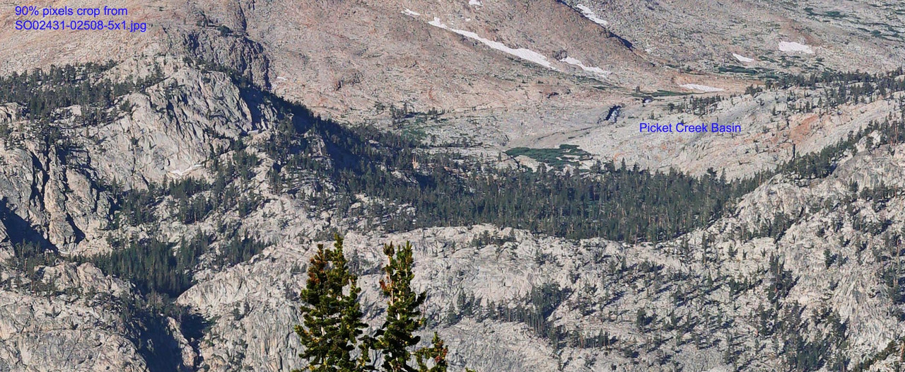
When we judged that we were opposite the (relatively) spaced contours on the S side of the creek we crossed the creek and started up. As per the contour map and online suggestions, we angled to the SE as we climbed, generally moving in the direction towards the lowest Pickett Basin lake.
But we got ‘stuck’ at a certain point. In retrospect we were trying ascend too early when we needed to continue SE towards the nose of the ridge there. It was 5pm, and the lure of the attractive creek back below was enticing. In the end the other five headed back down to a campsite along the Colby Pass trail, whereas I – loathe to give up the elevation that had been climbed and confident that I could reach at least Pickett Basin – continued on up.
And in fact I did get there - though I did it in a round-about way, eventually arriving at the lowest Pickett Lake from its SE as dusk was setting in. An attractive little lake with a rim holding it in from spilling into the Colby Pass trail valley below. With nice camping areas on either side of the lake inflow.
Communication via our Garmins confirmed that Megan & Julia would stay by the creek along the Colby Pass trail, that I would spend the next two days in the Kaweah Basin area, and Trekker9/Slabwalker/JP would choose their next move when inspiration hit.
DAY 5
In our various locations we all needed a layover day – it had been a hard first 4 days for most of us. I in particular had arrived at campsites at or near dusk on each of those days.
Megan, Julia, Trekker9, Slabwalker and JP stayed in the Colby Pass trail valley this day and enjoyed the creek running over slabs through the valley. They moved camp upstream a mile or so to a more attractive campsite.
I spent the morning at the lowest Pickett lake exploring a bit and washing up.
Lowest Pickett Lake
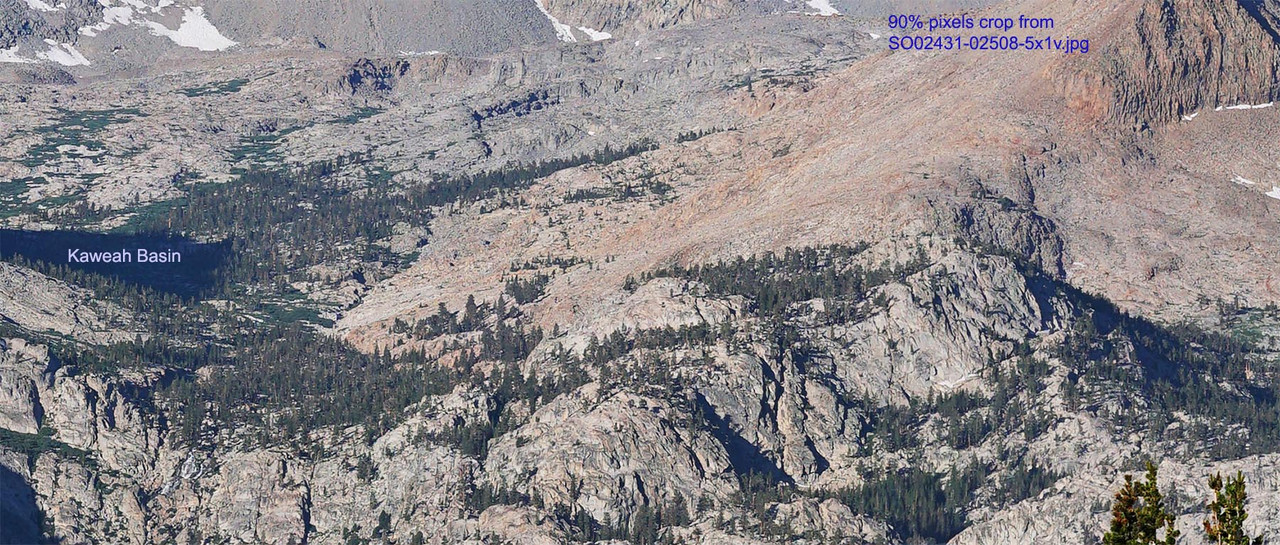
In the afternoon I packed up to make the easy trek over Pickett Creek Pass to the lowest Kaweah Basin lake. It was not as fun as I expected. First, the ridge between the Pickett and Kaweah basins is a slightly different type of rock than your standard granite – a little more reddish/brown. I experienced it as more broken up rock such that even though it wasn’t particularly steep it took me time to pick my way along through the pieces of rock.
SW View from Pickett Creek Pass
In addition there were a series of gullies running parallel to the Kaweah watercourse that had to be climbed in and out of as I proceeded down the SE side of the pass. Finally even though the map suggests that the terrain is flattish around the lowest Kaweah lake, it’s not particularly level. I found a shelf suitable for one person near the lake inflow and camped there for the night.
Trekker9: We awoke at the campsite we had made our way down to, on tired legs, the previous evening. It was lightly forested, with a campfire ring and good creek access. Around breakfast we all agreed that a layover day was desired, and messaged my dad on the inReach to let him know. Our camp was beneath the Class 1-2 slope we had attempted to go up the prior evening. It was the natural thing to look at and discuss while breakfasting, trying to draw lines to determine the route. In the end it wasn’t that complicated, but it is just hard to tell from the bottom, where there is a warped perspective of slope angles.
Shortly after breakfast, we all resumed resting. Some went to wash up in the creek. I slept for a couple more hours. Our bodies were tired after four long hiking days!
Meanwhile, Slabwalker scouted about a mile up the canyon and reported back on a good campsite. Early-afternoon, we all leisurely moved camp. It was as-advertised. Wide open with big slabs, good creek access, and another excellent fire ring (still below 10k ft). It was a warm day. Slabwalker tried to decide the exact premium he would pay for a chocolate milkshake heli-dropped at his feet, while JP thought about Huevos Rancheros. The boys played chess, and we all rested and wandered around camp.
The evening ended with another campfire, and cookies. There was a big moon that night. When I got up in the middle of the night, I didn’t need a headlamp to navigate, because the moon lit up the granite walls around us.
{continued}
Our committed group on these trips is my sisters Megan and Julia (in their 60s), daughter Trekker9 and her husband Slabwalker (early-mid 30s) and self (now 72). On occasion other family members or friends join us. This August Slabwalker & Trekker9’s friend JP came with us to make a party of six.
[Last year – 2023 – our backpack didn’t happen. I had ankle replacement surgery and Slabwalker had ACL surgery, both in June of 2023 - neither of us could hike that summer.]
Our target this year was to reach Kaweah Basin. In 2017 we attempted to get to Kaweah from the Cottonwood Pass trailhead. Our 2017 schedule called for us to get to the basin in three days. This turned out to overly ambitious for our group… at the end of 3 days we were in Junction Meadow (Kern River version) and – because of a landslide during the previous heavy winter – were facing a difficult crossing of the Kern to proceed. So that year we aborted our plan and went north to Milestone Basin instead.
This year – to increase our chances of reaching Kaweah – we extended our trip to 11 days in the backcountry. In addition we looked at other routes to get there, and some of us settled on crossing Russell-Carillon Pass from the Whitney Portal trailhead as a relatively direct route to Kaweah.
As this trip report describes, the six of us were apart for major portions of the trip – in fact we only all camped together for one night out of the ten. Some of these separations were planned, others not. Between the 6 of us we had 3 Garmin Inreach units and so could (laboriously) text one another to communicate locations and plans.
This Trip Report is primarily mine, but also including inserts from Trekker9, Slabwalker and Megan to report on events/routes for which I wasn’t present.
Overall the weather was great. There was a cold front that came through on days 9 & 10. Mosquitos were not to be seen. There was smoke/haze that came in every afternoon in the western (Kaweah/Colby) region of our trek – photos were best taken in the mornings for sharpness.
DAY 1 (August 15th)
All six of us entered the mountains on this day, but in two groups from two different trailheads. Megan and Julia began from the Cottonwood Pass trailhead. They had a packer bring in their packs to Rock Creek on that first day – thus they enjoyed hiking their first 12 miles with daypacks only, knowing that their food and gear would be waiting for them. That went well!
Trekker9, Slabwalker, JP and I began from the Whitney Portal trailhead, heading up the North Fork of Lone Pine Creek towards Russell-Carillon Pass. Our first night’s goal was Upper Boy Scout Lake – less than 3 miles of horizonal hiking, but a 3000’ climb. We four were fairly leisurely about our start – camping at Convict Lake the night before, stopping in Bishop on the drive, and beginning the hike around noon. All went well enough. 3000’ vertical feet is a tough slog with full packs. The ‘ledges’ at about 10,000’ feet elevation were a challenge – part of that challenge just to discern what was intended to be the ‘trail’ in this area.
Then we were up out of the steep gorge, past Lower Boy Scout Lake, across the talus, up the granite slabs to Upper BSL.
I was knackered by Lower BSL, and Slabwalker helped me transport my pack on and off up the last 1000’. I have an awesome SiL!
DAY 2
On this day Megan and Julia shouldered their packs and headed north on the PCT. They reached the Crabtree Meadow camping area, then decided to push on a little farther north to avoid the crowds and achieve a little more distance. They filled up with water and continued another ½-mile before dry camping near the trail.
Trekker9, Slabwalker, JP and I had the goal of crossing Russell-Carillon Pass and reaching Wallace Lake for this day’s hike.
In recent years Slabwalker has taken to climbing non-technical peaks near our hiking route as we proceed – he can generally do this and still easily keep up with my pace. This was a day for this strategy. After breakfast I started up the long sandy slog directly from Upper BSL.
Trekker9 gave me a head start and then followed. Slabwalker and JP headed up the alternate route to the NW – continuing up the Upper BSL canyon and then swinging around to the N and NE under Mt Russell. Trekker9 and I made it up through the sand, then across the ‘flat’ on the top and arrived at R-C Pass just as Slabwalker and JP arrived there after Slabwalker summited Mt Russell.
We snacked on top. Trekker9 and I started down the north side; Slabwalker and JP went over and summitted Mt Carillon first. I’m painfully slow on my reconstructed ankle, particularly going down on talus – I don’t have the balance/confidence to step down heavily on it yet. So T, A and J had plenty of time at the bottom waiting for me. Then off to the NW past Tulainyo Lake, over a snowbank and down to the west through the meadows, over a rim and down to Wallace Lake. Slabwalker put down his pack to summit Tunnabora Peak, JP went with him partway and then also headed west to Wallace Lake. Our goal was to camp near the mouth of the lake. JP arrived first, then Trekker9 and I staggered in, with Slabwalker following. Headaches and nausea were generally shared among us this night – elevation, and maybe having to look into the setting sun for the last hours of our hike contributed. Our appetites for dinner were minimal.
(Slabwalker addition) The route up to the high shoulder of Russell above RC has a name: "Rockwell Variation". It is a very non-dangerous but physically demanding slog, involving repeated short series of "power" steps through steepish scree to get from one stable area to another for rests.
DAY 3
On this day the six of us planned to meet at Junction Meadow (Kern River). Megan and Julia accomplished this on-trail – continuing north on the PCT/JMT, turning west at Wallace Creek and down to the Kern River.
Trekker9, Slabwalker, JP and I walked down through the Wallace Creek canyon. It’s a beautiful place for a morning stroll – over ridges with sparse forest, along the creek, across various meadows.
Downhill, but not steeply. The map shows a use trail up through the canyon. In fact there are multiple use trails appearing and disappearing– it’s easiest if one doesn’t get hung up on trying to follow one trail in particular.
At some point Slabwalker and JP pushed on ahead. Trekker9 and I reached the PCT/JMT, snacked, and continued west. After the Wright Creek crossing Trekker9 also stepped up her pace, and I eventually also reached our Junction Meadow campsite with (a little) daylight to spare.
We spend a lot of our Sierra time above treeline, so the tall pines and forested feel of this area is a nice change. Plus being low enough to have a campfire.
Trekker9: One interesting thing we saw this day, in the lightly timbered areas not far below Wallace Lake, was an obsidian arrowhead. Just a few feet away was a bit of modern human trash. A contrast of what humans leave behind them, several hundred years apart.
DAY 4
Today our hope was to all get to Kaweah Basin. This involved hiking west on the Colby Pass trail, then at an opportune time crossing the creek and angling up the slope into the Pickett Creek basin from where Kaweah Basin was accessible.
The lower section of the Colby Pass trail is not trivial. It’s a brushfield, and hasn’t been maintained as a trail for some time. Thus one is often walking through the brush while peering down into it looking for the direction of the trail.
Then up alongside and past the knoll that sits in the middle of the canyon, back down to the creek (where we had lunch) and on to the west on the trail – out of the brush now and easy enough to follow.
When we judged that we were opposite the (relatively) spaced contours on the S side of the creek we crossed the creek and started up. As per the contour map and online suggestions, we angled to the SE as we climbed, generally moving in the direction towards the lowest Pickett Basin lake.
But we got ‘stuck’ at a certain point. In retrospect we were trying ascend too early when we needed to continue SE towards the nose of the ridge there. It was 5pm, and the lure of the attractive creek back below was enticing. In the end the other five headed back down to a campsite along the Colby Pass trail, whereas I – loathe to give up the elevation that had been climbed and confident that I could reach at least Pickett Basin – continued on up.
And in fact I did get there - though I did it in a round-about way, eventually arriving at the lowest Pickett Lake from its SE as dusk was setting in. An attractive little lake with a rim holding it in from spilling into the Colby Pass trail valley below. With nice camping areas on either side of the lake inflow.
Communication via our Garmins confirmed that Megan & Julia would stay by the creek along the Colby Pass trail, that I would spend the next two days in the Kaweah Basin area, and Trekker9/Slabwalker/JP would choose their next move when inspiration hit.
DAY 5
In our various locations we all needed a layover day – it had been a hard first 4 days for most of us. I in particular had arrived at campsites at or near dusk on each of those days.
Megan, Julia, Trekker9, Slabwalker and JP stayed in the Colby Pass trail valley this day and enjoyed the creek running over slabs through the valley. They moved camp upstream a mile or so to a more attractive campsite.
I spent the morning at the lowest Pickett lake exploring a bit and washing up.
In the afternoon I packed up to make the easy trek over Pickett Creek Pass to the lowest Kaweah Basin lake. It was not as fun as I expected. First, the ridge between the Pickett and Kaweah basins is a slightly different type of rock than your standard granite – a little more reddish/brown. I experienced it as more broken up rock such that even though it wasn’t particularly steep it took me time to pick my way along through the pieces of rock.
In addition there were a series of gullies running parallel to the Kaweah watercourse that had to be climbed in and out of as I proceeded down the SE side of the pass. Finally even though the map suggests that the terrain is flattish around the lowest Kaweah lake, it’s not particularly level. I found a shelf suitable for one person near the lake inflow and camped there for the night.
Trekker9: We awoke at the campsite we had made our way down to, on tired legs, the previous evening. It was lightly forested, with a campfire ring and good creek access. Around breakfast we all agreed that a layover day was desired, and messaged my dad on the inReach to let him know. Our camp was beneath the Class 1-2 slope we had attempted to go up the prior evening. It was the natural thing to look at and discuss while breakfasting, trying to draw lines to determine the route. In the end it wasn’t that complicated, but it is just hard to tell from the bottom, where there is a warped perspective of slope angles.
Shortly after breakfast, we all resumed resting. Some went to wash up in the creek. I slept for a couple more hours. Our bodies were tired after four long hiking days!
Meanwhile, Slabwalker scouted about a mile up the canyon and reported back on a good campsite. Early-afternoon, we all leisurely moved camp. It was as-advertised. Wide open with big slabs, good creek access, and another excellent fire ring (still below 10k ft). It was a warm day. Slabwalker tried to decide the exact premium he would pay for a chocolate milkshake heli-dropped at his feet, while JP thought about Huevos Rancheros. The boys played chess, and we all rested and wandered around camp.
The evening ended with another campfire, and cookies. There was a big moon that night. When I got up in the middle of the night, I didn’t need a headlamp to navigate, because the moon lit up the granite walls around us.
{continued}