Desolation Tallac warm-up photo backpack
Posted: Sun Jun 09, 2024 2:06 pm
An example below of how in this era a serious photographer uses online map and satellite resources on a desktop/laptop with today June 9, 2024. Ought to complete in a few days, HTML coding and uploading into my website of all my considerable and surprising productive spring a6700 work to this point. After that will concentrate on this late June backpack.
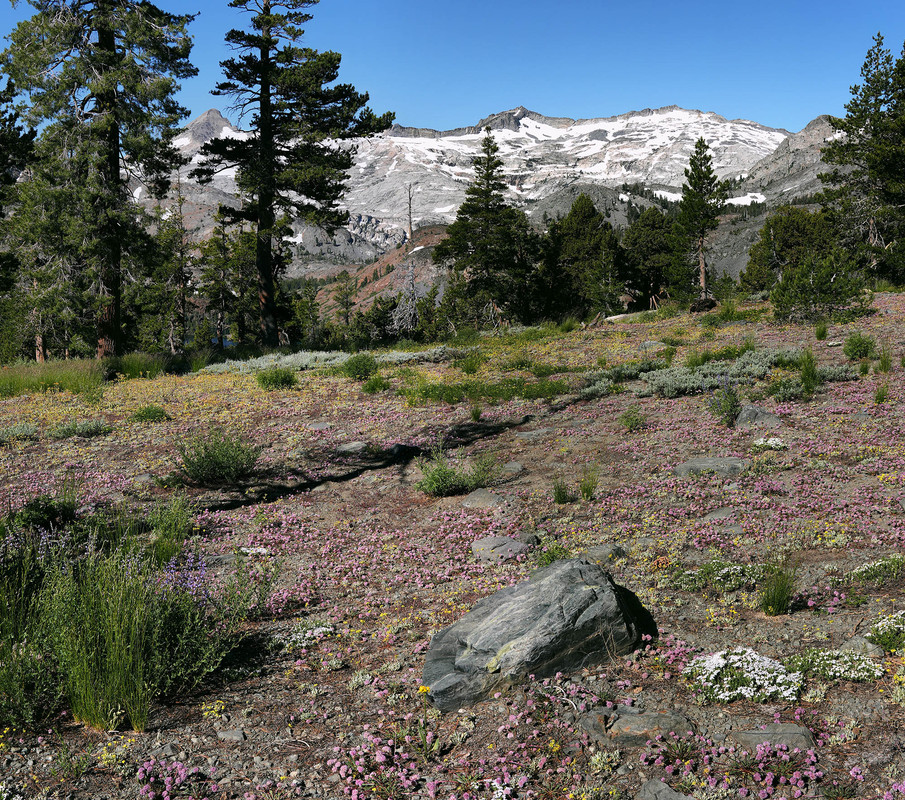
Will likely at short notice, obtain a midweek solo backpack wilderness permit on recreation dot gov a few days before this tentative trip dependent on weather conditions of sun and a clear dry atmosphere without thunderstorms or strong wind. So will morning drive east via US50 to Tahoe. On the Copernicus.eu browser, these areas have just now melted out and given a warm forecast, shows the region in the near period will be under a heat dome. So I can expect given experience, that in 2 weeks or June 23+, vegetation greenery and early wildflowers will have exploded. In the distance west, areas with patchy snows will still grace green landscapes while foregrounds ought contain optimal elements for best images. May even manage some reflections off snow melt ponds. A good lower gear weight summer warm up trip for this old guy lugging his new Sony a6700 with focus bracketing.
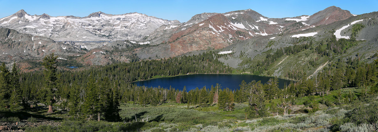
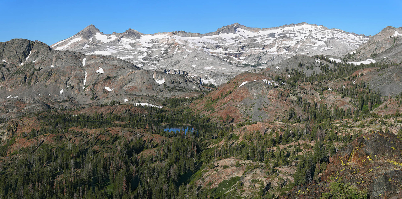
On a mid day from the Glen Alpine trailhead at 6550, I'll be taking El Dorado National Forest trail 17E06.1, a rocky trail with scree, that goes to Gilmore Lake but not quite to that lake at 8320 feet. Instead will set up about a half mile southeast about a Mt Tallac slope stream zone off the trail at the rim of the canyon at about 8250 feet at 38°53'16.76"N 120° 6'25.49"W where I've made a Google Earth (GE) placemark, I've named TallacW-camp that I can easily map locate for more analysis including jumping about point to point. That canyon rim knee is where winds from the west are stronger and Sierra juniper trees are most likely to be aesthetically wind shaped. The Glen Alpine Creek basin in my experience due to geology and elevation, has some of the most aesthetic junipers in the range that I've been occasionally working over decades. Since I hike slowly given carrying weight, that might be 3 hours including many brief stops along the route as am in no hurry and also prefer to enjoy these experience without too strenuous an effort. Thus may reach my camp zone mid afternoon while eastward light is still a bit harsh. That will allow some time for me to make a camp and relax.
https://caltopo.com/map.html#ll=38.8846 ... structures
The top of volcanic geology Mt Tallac at 9735, offers superb morning views westward towards Gilmore, Susie, Heather, Aloha, and the granitoid Crystal Range. From the above rim position that I've never actually walked, one is half the distance to Susie Lake versus the top of Tallac with more frame impact. Zoomed in, switched to the Caltopo NAIP base map, if one, selects the Ruler icon to measure Distance, yellow trail lines will appear. Then by switching the distance measurement mode back and forth, one will easily be able to make out this very lightly used old trail that isn't on the USGS topo.
https://caltopo.com/map.html#ll=38.8872 ... structures
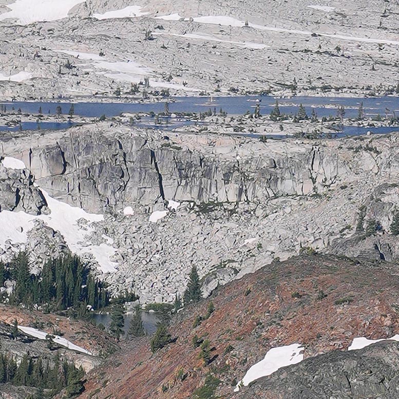
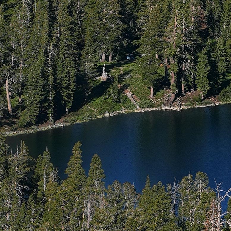
Looking at the same area with Google Earth provides higher detail to the zone. By using the 6/29/2018 historical imagery that is near the same date of my visit with a few snow patches still melting, one will also note some shallow ephemeral ponds and trail 17E06.1 is more visible as well as mentioned junipers. By orienting that zone northwestward with Gilmore in the background and playing with 3D to level a bit, one will note a nice stream green zone with trees for shade I'll likely tent somewhere at and have added a GE placement, TallacW-camp. Then by placing the Street View icon there and rotating around for a westward view, one will see the morning view I expect. Since it is lower than the top of Tallac, one won't see Aloha and just a bit of Heather.
After working that zone that the day 2 morning, I'll climb up about 700 feet to a knob at 8920 below Tallac where it appears via GE that all those lakes including Gilmore, are visible including Pyramid Peak to rusty Dicks Peak. By adding a GE placemark at that location I've named Crystal-am1, I can always return to it. It also shows the exact location as: 38°53'48.85"N 120° 6'9.56"W. By GE zooming out and using its Ruler Distance tool, one will note from where I expect to camp, the Crystal-am1 placemark is almost directly towards the top of Tallac, 6900 feet horizontally away while Crystal-am1 shows 3600 feet. Next by placing the GE Street View icon at my camp zone, it will show the top of Tallac is often visible at ground level. Thus I should be able to directly visually navigate towards the slight knob with just photo gear, that may not be obvious until getting near. Below the GE Street View icon, one can use the smaller navigation circle to travel towards the top of Tallac. Doing so, eventually the placemark becomes visible that I'll expect and then change to visual hiking. On day 2 after working the knob by later morning, will drop back down to TallacW-camp, pack up and hike back downhill towards the trailhead I ought reach mid afternoon allowing a modest 4 hour daytime drive home.
On the caltopo Forest Service base map, one can also use the Ruler icon Bearing tool to find that route is a 21 degree bearing (a bit east of due north) or 8.5 degrees magnetic I'll complement enroute with my compass. The Bearing tool will also show Susie Lake is at 245 degrees from TallacW-camp and 230 degrees from Crystal-am1 that is a good orientation for 8am>9am landscape shadowing. On the Caltopo Forest Service base map, by actuating the Ruler Distance tool that then displays noted yellow overlay lines on trails, one can also measure the 17E06.1 trail trailhead to TallacW-camp distance by moving a computer Mouse atop the yellow lines and that shows 1.8 miles. One can also select the Ruler Profile mode to create a profile graph with data showing:
distance: 1.79mi range: 6622' to 8340' gross: +1717'
About 4pm on day 1, will dayhike northwest to another photo location on the rib west of Gilmore I've named GE placemark Gilmore-pm1 at 8560 elevation that shows 4550 feet horizontal distance up an easy 350 feet where I expect to have a 30mm lens mid ground view of all of nicely round and deep blue Gilmore with Tallac directly above in the distance with a bit of residual snows about slopes. Because that rib is near and tall to Gilmore, I cannot shoot this too late as sun shadows will move over the lake.
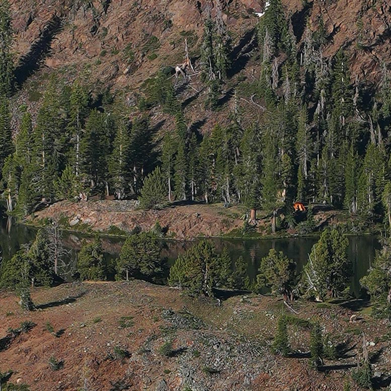
After visiting Gilmore Lake west shores below for possible eastward photos, may be back at camp by 6:30pm with plenty of time for cooking a can of soup dinner. By the 8:15pm, dusk sky colors westward over Dicks Peak ought to be interesting from one of the camp zone snow melt ponds for a possible reflection. Likewise at dawn from those same ponds, there may be a reflection of the pink Earth shadow over the Crystal Range with some color picked up by Susie in the distance. In the next couple weeks, will revisit these GE placemarks now temporarily saved on my laptop and along with some GE window captures and map captures, copy them to my old smartphone, I can during the trip use for reference.
Will likely at short notice, obtain a midweek solo backpack wilderness permit on recreation dot gov a few days before this tentative trip dependent on weather conditions of sun and a clear dry atmosphere without thunderstorms or strong wind. So will morning drive east via US50 to Tahoe. On the Copernicus.eu browser, these areas have just now melted out and given a warm forecast, shows the region in the near period will be under a heat dome. So I can expect given experience, that in 2 weeks or June 23+, vegetation greenery and early wildflowers will have exploded. In the distance west, areas with patchy snows will still grace green landscapes while foregrounds ought contain optimal elements for best images. May even manage some reflections off snow melt ponds. A good lower gear weight summer warm up trip for this old guy lugging his new Sony a6700 with focus bracketing.
On a mid day from the Glen Alpine trailhead at 6550, I'll be taking El Dorado National Forest trail 17E06.1, a rocky trail with scree, that goes to Gilmore Lake but not quite to that lake at 8320 feet. Instead will set up about a half mile southeast about a Mt Tallac slope stream zone off the trail at the rim of the canyon at about 8250 feet at 38°53'16.76"N 120° 6'25.49"W where I've made a Google Earth (GE) placemark, I've named TallacW-camp that I can easily map locate for more analysis including jumping about point to point. That canyon rim knee is where winds from the west are stronger and Sierra juniper trees are most likely to be aesthetically wind shaped. The Glen Alpine Creek basin in my experience due to geology and elevation, has some of the most aesthetic junipers in the range that I've been occasionally working over decades. Since I hike slowly given carrying weight, that might be 3 hours including many brief stops along the route as am in no hurry and also prefer to enjoy these experience without too strenuous an effort. Thus may reach my camp zone mid afternoon while eastward light is still a bit harsh. That will allow some time for me to make a camp and relax.
https://caltopo.com/map.html#ll=38.8846 ... structures
The top of volcanic geology Mt Tallac at 9735, offers superb morning views westward towards Gilmore, Susie, Heather, Aloha, and the granitoid Crystal Range. From the above rim position that I've never actually walked, one is half the distance to Susie Lake versus the top of Tallac with more frame impact. Zoomed in, switched to the Caltopo NAIP base map, if one, selects the Ruler icon to measure Distance, yellow trail lines will appear. Then by switching the distance measurement mode back and forth, one will easily be able to make out this very lightly used old trail that isn't on the USGS topo.
https://caltopo.com/map.html#ll=38.8872 ... structures
Looking at the same area with Google Earth provides higher detail to the zone. By using the 6/29/2018 historical imagery that is near the same date of my visit with a few snow patches still melting, one will also note some shallow ephemeral ponds and trail 17E06.1 is more visible as well as mentioned junipers. By orienting that zone northwestward with Gilmore in the background and playing with 3D to level a bit, one will note a nice stream green zone with trees for shade I'll likely tent somewhere at and have added a GE placement, TallacW-camp. Then by placing the Street View icon there and rotating around for a westward view, one will see the morning view I expect. Since it is lower than the top of Tallac, one won't see Aloha and just a bit of Heather.
After working that zone that the day 2 morning, I'll climb up about 700 feet to a knob at 8920 below Tallac where it appears via GE that all those lakes including Gilmore, are visible including Pyramid Peak to rusty Dicks Peak. By adding a GE placemark at that location I've named Crystal-am1, I can always return to it. It also shows the exact location as: 38°53'48.85"N 120° 6'9.56"W. By GE zooming out and using its Ruler Distance tool, one will note from where I expect to camp, the Crystal-am1 placemark is almost directly towards the top of Tallac, 6900 feet horizontally away while Crystal-am1 shows 3600 feet. Next by placing the GE Street View icon at my camp zone, it will show the top of Tallac is often visible at ground level. Thus I should be able to directly visually navigate towards the slight knob with just photo gear, that may not be obvious until getting near. Below the GE Street View icon, one can use the smaller navigation circle to travel towards the top of Tallac. Doing so, eventually the placemark becomes visible that I'll expect and then change to visual hiking. On day 2 after working the knob by later morning, will drop back down to TallacW-camp, pack up and hike back downhill towards the trailhead I ought reach mid afternoon allowing a modest 4 hour daytime drive home.
On the caltopo Forest Service base map, one can also use the Ruler icon Bearing tool to find that route is a 21 degree bearing (a bit east of due north) or 8.5 degrees magnetic I'll complement enroute with my compass. The Bearing tool will also show Susie Lake is at 245 degrees from TallacW-camp and 230 degrees from Crystal-am1 that is a good orientation for 8am>9am landscape shadowing. On the Caltopo Forest Service base map, by actuating the Ruler Distance tool that then displays noted yellow overlay lines on trails, one can also measure the 17E06.1 trail trailhead to TallacW-camp distance by moving a computer Mouse atop the yellow lines and that shows 1.8 miles. One can also select the Ruler Profile mode to create a profile graph with data showing:
distance: 1.79mi range: 6622' to 8340' gross: +1717'
About 4pm on day 1, will dayhike northwest to another photo location on the rib west of Gilmore I've named GE placemark Gilmore-pm1 at 8560 elevation that shows 4550 feet horizontal distance up an easy 350 feet where I expect to have a 30mm lens mid ground view of all of nicely round and deep blue Gilmore with Tallac directly above in the distance with a bit of residual snows about slopes. Because that rib is near and tall to Gilmore, I cannot shoot this too late as sun shadows will move over the lake.
After visiting Gilmore Lake west shores below for possible eastward photos, may be back at camp by 6:30pm with plenty of time for cooking a can of soup dinner. By the 8:15pm, dusk sky colors westward over Dicks Peak ought to be interesting from one of the camp zone snow melt ponds for a possible reflection. Likewise at dawn from those same ponds, there may be a reflection of the pink Earth shadow over the Crystal Range with some color picked up by Susie in the distance. In the next couple weeks, will revisit these GE placemarks now temporarily saved on my laptop and along with some GE window captures and map captures, copy them to my old smartphone, I can during the trip use for reference.