Page 1 of 2
Hiking an Abandoned Trail, Kaweah River Canyon
Posted: Mon Aug 30, 2021 4:29 pm
by sekihiker
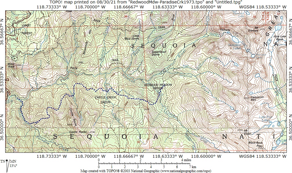
In 1972, my wife and I tried to follow an old Civilian Conservation Corps [CCC] trail built in the 1930's that went from Redwood Meadow to Paradise Creek on the south slope of the Middle Fork of the Kaweah River canyon. The trail is shown on the 1970 Starr's Guide map. Kaweah River Canyon is the deep canyon between Moro Rock and the Great Western Divide. The High Sierra Trail goes up it on the canyon's north side.
We started from Redwood Meadow in the morning. We tried to follow the old, abandoned, CCC trail but were blocked by deadfalls up to five trees high. We made our way cross country most of the time and as evening approached, we had to camp off trail on the side of the canyon. My wife reminds me that we had to dig out a flat area.
We slept well but were awakened by a "kathunk" sound that came from a tall stump at the foot of our sleeping bags. I looked up at one of the largest owls I've ever seen who was eyeing my toes which stuck out of the bottom of the bag. I quickly pulled them back in and the owl flew off.
We finally picked up the trail again near Castle Rocks. The rest of the trip was unremarkable except for the amazing switchbacks that the CCC crew had built to descend to Paradise Valley that were still in good shape even though they hadn't been maintained for about 40 years.
After reading the above, my wife said she was glad I had left out the terrifying details.
There are no photos because the entire trip was through forest.
Re: Hiking an Abandoned Trail, Kaweah River Canyon
Posted: Tue Aug 31, 2021 12:49 pm
by Shawn
Very cool report which I image is embossed forever in your mind given the circumstances (the owl among other things). I've got a few old maps purchased just to see some trails that were abandoned long ago, but I hadn't ventured out to them as you have.
Re: Hiking an Abandoned Trail, Kaweah River Canyon
Posted: Wed Sep 01, 2021 10:52 am
by Rockyroad
Bill, thanks for the entertaining report. The owl sighting would be rewarding enough for me to hike through that forest. But the unknown "terrifying details" will keep me away.
Re: Hiking an Abandoned Trail, Kaweah River Canyon
Posted: Sat Sep 11, 2021 7:57 am
by tweederjohnson
I love reports from abandoned trails. They add a sort of mystery to the trip and make one wonder what led to the trail falling out of favor (though in this case, I imagine it's the forest cover where other nearby trails probably offer more open views). Defintiely curious about the 'terrifying details' though. Any chance in sharing some of those?
Re: Hiking an Abandoned Trail, Kaweah River Canyon
Posted: Sat Sep 11, 2021 9:57 am
by creekfeet
tweederjohnson wrote: ↑Sat Sep 11, 2021 7:57 am
I love reports from abandoned trails. They add a sort of mystery to the trip and make one wonder what led to the trail falling out of favor (though in this case, I imagine it's the forest cover where other nearby trails probably offer more open views). Defintiely curious about the 'terrifying details' though. Any chance in sharing some of those?
I'm a huge fan of hiking abandoned trails myself. There's something so satisfying about searching for old rock work, tree markings, etc., almost like solving a puzzle. For SEKI I'd say there's primarily two reasons trails have fallen out of favor:
1. As stock use has declined over the years, trails designed more for this use have been left to die.
2. Parks used to have a much larger budget for trail maintenance/building. If you look at old maps of SEKI, there used to be miles and miles of trails in the mid-elevations, below where sequoias grow. However, a decision was made to abandon these trails because vegetation, especially poison oak, grows like mad in that zone, thus the trails require way more maintenance than trails in the much more barren high sierra. The one mid-elevation trail I really wish they'd bring back is the Black Oak Trail, a route that once connected numerous sequoia groves that can now only be reached by excessive bushwhacking.
Anyhow, thanks to Bill for sharing this route with us! I'm guessing 50 years later there's no semblance of this trail left, but it would certainly be an adventure to go out there and take a look around.
Re: Hiking an Abandoned Trail, Kaweah River Canyon
Posted: Sat Sep 11, 2021 1:41 pm
by SweetSierra
I read that some trails in the mid elevation of the Sierra (west side) were abandoned because they fell into disuse after the backpacking boom of the 1970s. Hikers used to flock to certain places during that time, but then hikers hiking those trails dwindled over time until very few to none traveled to these areas. So nature took them over. There was one trail I hiked to I think the South Fork of the San Joaquin that winded its way through forest and brush to a streamside camp. It has likely vanished.
Re: Hiking an Abandoned Trail, Kaweah River Canyon
Posted: Sun Sep 12, 2021 10:57 pm
by druid
Thanks for your entertaining trip report. I too enjoy searching for and following trails in various stages of abandonment. Last summer I had plans to hike the old trail from Big Arroyo to Rattlesnake Creek before the Rattlesnake Fire put a kibosh to that idea. It's ironic that so soon after your report something similar is now in the process of happening to the route you hiked 49 years ago. On the bright side I suppose the views will open up (although not in a good way, at least not right away) and I guess a lot of the deadfall you waded through will burn away although there will certainly be more to replace it. Maybe in a few decades there will be a brand new forest for the next generation of hikers to enjoy. At least I hope so.
Re: Hiking an Abandoned Trail, Kaweah River Canyon
Posted: Mon Sep 13, 2021 9:14 am
by sekihiker
tweederjohnson wrote: ↑Sat Sep 11, 2021 7:57 am
Defintiely curious about the 'terrifying details' though. Any chance in sharing some of those?
I asked my wife what bothered her the most. She said she was constantly worried we would never be able to get out of the forest.
This has been a theme on many of our adventures. We were stuck in the sand up to the pan in our VW on New Year's Day on Punta San Hipolito, Baja. The sun was setting and we had perfect reception of the Rose Bowl game on the car radio, so I settled in to follow the game. My wife was really distraught until I dug the car out the next morning. It was difficult for her to be so far away from civilization.
creekfeet wrote: ↑Sat Sep 11, 2021 9:57 am
I'm guessing 50 years later there's no semblance of this trail left, but it would certainly be an adventure to go out there and take a look around.
I wonder if fire crew is using the trail to fight the Paradise fire that is burning south of the Kaweah Middle Fork.
During the Rough Fire in 2015, crew used the trail between the Crown Valley Trail and Spanish Lake and really cleaned it up.
Maybe the same thing will happen with the trail to Castle Rocks.
SweetSierra wrote: ↑Sat Sep 11, 2021 1:41 pm
I read that some trails in the mid elevation of the Sierra (west side) were abandoned because they fell into disuse after the backpacking boom of the 1970s.
That could be. I believe the trail I'm talking about was built for stock to serve the ranger station at Redwood Meadow.
I've hiked two other abondoned trails in the area.
On the Sphinx Lakes trail I found a horseshoe just below the first Sphinx Lake.
On the trail up Cunningham Creek, over Longley Pass, and down to Lake Reflection, I found a packer camp with lots of very old bottles and cans and a horseshoe driven into a tree trunk.
So, most of the abandoned trails I've hiked have been built for stock.
druid wrote: ↑Sun Sep 12, 2021 10:57 pm
Last summer I had plans to hike the old trail from Big Arroyo to Rattlesnake Creek before the Rattlesnake Fire put a kibosh to that idea. It's ironic that so soon after your report something similar is now in the process of happening to the route you hiked 49 years ago.
What a coincidence that a fire starts burning at the west end of the trail right after I posted this.
I've hiked part of the trail to Rattlesnake Creek, but we left it and went cross country along Big Arroyo down to Kern Canyon. It was 1959 on my first extended hike in high country. We continued up to the Kern headwaters, went over Forester Pass, and exited at Roads End near Cedar Grove.
Re: Hiking an Abandoned Trail, Kaweah River Canyon
Posted: Wed Sep 15, 2021 9:35 am
by sekihiker
It looks like the KNP Complex fire is moving east across the old trail we took 50 years ago. Back then it looked like a disaster [fire] waiting to happen. I wonder what the forest fuel load looks like now after another 50 years of fire suppression. The huge black scar that will be the product of this fire isn't going to look good from the High Sierra Trail for the next decade or two.
https://caltopo.com/map.html#ll=36.4845 ... 2Cmodis_mp
Re: Hiking an Abandoned Trail, Kaweah River Canyon
Posted: Fri Sep 17, 2021 12:13 pm
by sekihiker
The fire that is mostly south of the Kaweah River is now called the Paradise KNP Complex fire.
It continues to move east through the heavily forested north facing slope of the Kaweah River.
https://caltopo.com/map.html#ll=36.5024 ... 2Cmodis_mp