Page 1 of 3

R03 TR: Taboose Pass with Bears, 4/27 - 4/30 2021

Posted: Tue May 04, 2021 10:07 pm
by Harlen
Finally a nice weather window opened up for me, but I managed to trip myself up in five ways, fell into the window and almost broke it.  I fell through on the right side though, and still went, but staggered off for my 8 hour drive at the woeful hour of 5:45 PM. My original plan was to jump up and go at 2 AM and sacrifice the night's sleep for a 10 AM, Tues. start up Taboose Creek.  Instead, I left home more than 15 hours later... don't ask why.  On the drive there I was kicking myself, and also wondering if I should instead race up to Summit City Creek after all, but I had a WP for Taboose.  Then I wondered if I should pull up into The Santa Lucia Range of the Big Sur, which was so close!, and explore "The Indians" area.  The Eastern Sierra kept pulling me on... I even considered the 8,000' Pine Mountains area at the south end of the Central Valley, but no, I pulled off to the east on Hwy 58, willing to suffer 990 miles of driving for 3 days and nights in the Sierra.  At 2 AM I was bouncing up the wrong rocky road to the Taboose Cr. TH.  Slept for just 3 hours, and hiked off with a full moon.  But the comedy of errors continued when I realized that I was miles away from the TH.  Bad language, and then I went back to the car, and bashed my way another couple miles at least, stopping to remove small boulders from the road at least 5 times.  I was still more than a mile from the real TH, but no matter, as the Diné say, I was walking in beauty. 
The Bush Lupines were in full flower, and in the clear morning light the mountains were surreal.

100_0910.JPG

100_0912.JPG
The wide view up at eastern wall included colorful Split Mtn., the thin dark line is Taboose Creek.

100_0931.JPG
There were were Desert Paintbrush, and Evening Primrose.

100_0927.JPG

100_0930.JPG
 Behind Bearzy is the Taboose Cr. Canyon.  The trail begins with loose sand, but it grows nice lupine-- the scent was fantastic!


100_0937.JPG
 My ski pants were melting my legs, so I had to resort to hiking in red boxers with my HST  t-shirt.  I'm afraid I would have represented HST poorly, but I met no one.  


100_0936.JPG
Hiking through the burn zone was no problem.  Many plants, like this Water Birch, are regrowing from their stumps.


100_0943.JPG
The golden pillar of Mt Goodale is a highlight of the upper basin.


100_0950.JPG
Bearzy hears a Pika?!


100_0953.JPG
This is the broad gentle slope of Taboose Pass. It was late in the day when I arrived at the pass.  My plan was to camp on the pass, but the wind drove me over into the first trees I could camp in.  I camped one mile west of the pass under the west ridge of Cardinal Mt. So, illegal by 1 mile for a dog, but Bearzy made me promise to pack his **** out, so I did.


100_1025.JPG
I had thought of climbing Cardinal Mtn. seen here, since Bearzy would then be on nearly legal ground as the mountain is on the main divide-- the line between dog-legal Forest Service Land, and the K.C.National Park. 

100_0959.JPG
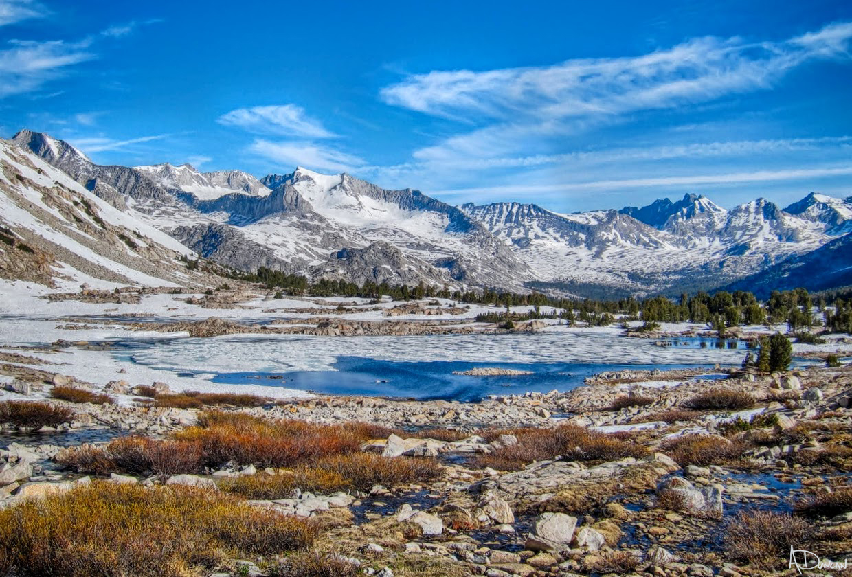
I really looked forward to seeing Arrow Peak with snow.  The western side of the divide was so different; while in Taboose Creek Canyon it felt like summer, in the middle of the range it looked and felt like spring again.  I cooked with snow for water, and was cold on the ground with Bearzy under our "quilt."   

Taboose Pass with Bears, 4/27 - 4/30, Part II

Posted: Tue May 04, 2021 10:24 pm
by Harlen
100_0998.JPG
 I brought too much gear, worrying about soft snow, and icyness high on the mountains I might have climbed.  The boots are mid-weight leather, Lowa mountain boots, nice and stiff for kicking steps in snow. The snowshoes are MSR Denalis, which are good and bad, and the crampons are lightweight aluminum.  Having the Whippet tool allowed me to lose the ice axe.  As it turned out, I didn't use any of it, but that doesn't necessarily mean I was stupid to carry it all ???  

100_0956.JPG
Sunset on the north wall of Mt. 13,259, and I believe my arrow points at the summit of Mt. Pinchot.


100_0966.JPG
 Sunrise and Moonset.


100_0963.JPG
The peaks of Cirque Crest, with Mt. Ruskin to the right.


100_0989.JPG
I had hoped to see Coyotes, Deer, or ?? crossing that wide snowy flat below our camp, but no luck.  Chipmunks and birdlife near our camp though.  It was nice to rest and gaze around at all of the intriguing high country.


100_0992.JPG

100_1005.JPG
We did climb to 12,000' on the west ridge of Cardinal to gain an even grander view.


100_1008.JPG
View north of the Upper Basin of the South Fork of the Kings.  Mt Sill and the Palisades in the distance.


100_1009.JPG
View westward from ridgetop.


100_1012.JPG
Northern extent of Cirque Crest-- Ruskin to Vennacher Needle.


100_1018.JPG
A view of T. Pass from the west, with the new metal sign on the skyline.


12.
100_1026.JPG
  Here is the old wooden sign.

Taboose Pass with Bears, 4/27 - 4/30, Part III

Posted: Tue May 04, 2021 10:37 pm
by Harlen
100_1035.JPG
Heading back east for our last night.


100_1039.JPG
I saw blood on the snow, and found that Bearzy had broken a dew claw. I wrapped it, and took his pack, Damn, I wish I could find the perfect booties; I am interested in those leather ones, as he hated the big blocky things.


100_1057.JPG
We camped in the creekside birch site.


100_1078.JPG
Bearzy's wounded paw. I carried his pack the rest of the way, plus a really cool rock sample from the pass... and GDit!, while removing an illegal firepit, I found a bunch of tinfoil, cans and crap to haul out. His claw healed well.


100_1046.JPG

100_1069.JPG

100_1065.JPG
What different scenery on the east side.


100_1084.JPG

100_1087.JPG
Birch.


100_1104.JPG
Willows in full flower.


100_1115.JPG
Mountain Mahogany growing right out of the cliffs

Taboose Pass with Bears, 4/27 - 4/30, Part IV

Posted: Tue May 04, 2021 11:00 pm
by Harlen
100_1108.JPG
Heading down to the forest belt at 9,000.' The White/Inyo Range in distance beyond the Owen's Valley.


100_1116.JPG

100_1124.JPG
Bearzy stopped and looked across the tight canyon, so I looked with him. What's he seen? Look in the middle, a quarter of the way across the frame, and click to enlarge.


100_1121.JPG
After a few of these poor photos, I watched the Bear well with my binos. It was a great view for ten minutes or so.


100_1126.JPG
Thanks for the Bear Bearzy!


100_1135.JPG
There are at least 6 places to get water on the way up and down Taboose Creek. I never carried more than a few ounces for Bearzy.


100_1155.JPG
The longest dry stretch is the first few miles. Bearzy in the shade with Penstemon flowers.


100_1156.JPG
Back in the burn zone.


100_1162.JPG


100_1139.JPG
Sceloporus Lizard, also saw some beautiful Leopard Lizards, and Desert or Granite Spinys, some Mule Deer and Ground Squirrels.


100_1164.JPG
The lowest slope, looking NE to White Mtn.


100_1166.JPG
We always stop to swim in Diaz Lake, 3 miles south of Lonepine. Lonepine Peak and Whitney in the distance.

This was a fun and challenging trip. I agonized over the decision whether to drive so far, and hike so hard for such a small amount of time. But I love the east side- even the driving along parts of Hwy 14, and 395. It was wonderful to be back the Sierra, and to finally see a real Bear again! (No offense Bearzy.) It is a nice cool, and flowery time to hike up this pretty canyon. Good Luck!

Re: Taboose Pass with Bears, 4/27 - 4/30

Posted: Tue May 04, 2021 11:15 pm
by Love the Sierra
Spectacular trip report, as always.
Thank you so much for posting!
I use the Mountain Ridge tough boots with grip or all grip boots. https://www.mtnridge.com/
The Velcro is above the dew claws so we do not have problems. I have been using their products for years. If you are in snow, you can get the standard booties. These are musher’s booties, so they stay on!

Re: Taboose Pass with Bears, 4/27 - 4/30

Posted: Tue May 04, 2021 11:22 pm
by Harlen
Bearzy made me promise to pack his **** out, so I did.
100_1016.JPG
Bearzy shite.


100_1073.JPG
Human shite.

Re: Taboose Pass with Bears, 4/27 - 4/30

Posted: Wed May 05, 2021 3:21 am
by Bluewater
Thank you for the beautiful photos and report. It’s good to read that Bearzy’s paw healed.

I have missed being in the Sierra for the last few years and your report really brought me back to some of my favorite east side stomping grounds.

The view of Upper Basin, Cirque Crest and Arrow Peak from the ridge at 12,000’ looks amazing. The snow levels look similar to June in 2016 when we did a spring trip through there.

. . .and that crazy wind at the top of Taboose Pass! I have sheltered from the wind after the long climb and camped in those trees just below the west side of the pass.

Thanks again Harlen. Your reports are much appreciated, especially during a time when I haven’t been able to be there in person :)

Image

Re: Taboose Pass with Bears, 4/27 - 4/30

Posted: Wed May 05, 2021 7:40 am
by johnz
Thank you for the report Harlen. The views from the west ridge of Cardinal are great and what a treat to be able to spy a bear ambling along the mountainside.

Re: Taboose Pass with Bears, 4/27 - 4/30

Posted: Wed May 05, 2021 7:55 am
by dougieb
I know that feeling when you are heading out for a long drive and wrestling with closer options in the middle of the night. Then you make the right decision to stick with the Sierra plan and you don't regret it. I was in this area last September and hiked down Sawmill Pass. It was so smoky I could barely make out arrow peak as I hiked through upper basin. Nice to see it in a snowy blanket. The wildflowers look beautiful too. Thanks for sharing.

Re: Taboose Pass with Bears, 4/27 - 4/30

Posted: Wed May 05, 2021 10:13 am
by Wandering Daisy
Wow, someone else does the same mental gymnastics I do every trip - as I drive down the road ask myself, do I go here, there, ???- then say, "stick to the plan, stupid".

I once did a point-to-point trip from South Pass to Taboose trailhead with plans to hitch a ride with someone going out. Well, nobody went out and I walked the road- a lot longer than I thought- ending up going all the way from the lakes below Striped Mountain in a day-ended up in dark, quarter mile short of the campground. Had I known I was that close I would have continued.

Your photos are worth a hundred remote images of snowpack. Thanks.

PS, I think I would have put the dog poop in a "cat hole" once on FS land.