Page 1 of 1
Can anyone identify this peak/area?
Posted: Sun May 03, 2020 1:14 pm
by TUIGoBlue

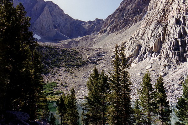
Was looking through a trip report and came across this picture. Does anyone know what peak it is or where it was taken from? The trip was in the Kern Basin/Lake Reflection area but I couldn't find anything similar in other trip reports. Thanks!
Re: Can anyone identify this peak/area?
Posted: Sun May 03, 2020 2:39 pm
by rlown
https://www.google.com/imgres?imgurl=ht ... gAegQIARAY
Mount Stanford and Kings-Kern Loop – Leor Pantilat's Adventures
Re: Can anyone identify this peak/area?
Posted: Sun May 03, 2020 3:43 pm
by CarlRaillard
Hello.
Those are the Ericsson Crags. Number 3 is the lowest, but it's also the closest to the tarn, so it stands proud and tall.
Here is Bob Burd's photo, for reference:
https://www.snwburd.com/bob/trip_photos ... 116_w.html
Sincerely,
Carl Raillard
Re: Can anyone identify this peak/area?
Posted: Tue May 05, 2020 12:42 pm
by SSSdave
Yeah EC, 2 decades+ ago 2 of us camped 3 nights close to that pond in the foxtails.
Re: Can anyone identify this peak/area?
Posted: Tue May 05, 2020 2:54 pm
by sekihiker
Lucy's Footpass to the right of the Mt Ericsson. It's a shame Lucy and Bolton Brown didn't spend a little more time in these mountains.
This closer view of the pass found in
http://www.sierrahiker.com/KernBasinI/index.html
Re: Can anyone identify this peak/area?
Posted: Tue May 05, 2020 4:05 pm
by Harlen
Carl writes:
Those are the Ericsson Crags.
I think you're right Carl. The highest peak is Erickson, and forward are the E.Crags.
Re: Can anyone identify this peak/area?
Posted: Fri May 15, 2020 2:40 am
by CarlRaillard
Harlen wrote: ↑Tue May 05, 2020 4:05 pm
Carl writes:
Those are the Ericsson Crags.
I think you're right Carl. The highest peak is Erickson, and forward are the E.Crags.
Yeah, I made a drawing of Ericsson recently. The job required studying the mountain's shape, and how it appears from various angles. I sent Bob Burd an email thanking him for his photos; I often use them, as reference material, when preparing my artmaps.
Ericsson is my favorite mountain in that neighborhood. From the summit you can see the airy bridge on Thunder Mountain, silhouetted against the sky. Also, Ericsson has an interesting glacier on its east side (the Harrison Pass side). In the lower part of the glaicer, among the associated piles of boulders, there is a moulin with a silty puddle in the bottom, and evidence of ice in the walls. Bob Burd took a photo of that dirty hole. Methinks rock glaciers are just ablation zones covered by boulders. It's possible the boulders serve as an insulating layer, much like the walls of a root celler, and help to keep the ice alive, longer, underneath.
Also, wolverines have been detected near Mount Ericsson! Check out the map, posted here.
http://www.highsierratopix.com/communit ... 66#p155266
Sincerely,
Carl Raillard