R01 TR: High Sierra Trail to Bearpaw Meadow June 20, 2017
Posted: Fri Jun 30, 2017 7:57 am
High Sierra Trail on a 3-day/2-night modified loop, made it 2 miles past Bearpaw Meadow. Mosquitos: pretty bad, deet helped. Creek crossings: dangerous. Started in Wolverton, ended at the General Sherman tree and took park shuttle back. See map.
Regarding Creek Crossings, It’s very hard to explain risk level and “perceived” danger; several creek crossings were a perilous threat for certain, risky- yes, reckless- not quite, but not much room for error just like rock climbing or skiing, a small mistake can be catastrophic. Comfort/risk/danger is relative and subjective to a certain point. Here’s how the trip went:
High Temperatures throughout the area for several days leading up to our hike, 113º near Visila and 109º at Buckey Flat near the park entrance as we drove in! This meant maximum snow-melt… Came into Lodgepole via Hwy-198 (Three Rivers), talked to the ranger before she closed the backcountry permit desk at 4pm (Visitor Center open till 4:30) and we decided against starting that evening on the HST- All creeks running very high, Reports of Mehrtern Creek sounding like the biggest obstacle. Decided to start the next morning (Tuesday) on a modified approach to the High Sierra Trail. Found (free) dispersed camping near Buck Rock Lookout on 4wd trail- very cool.
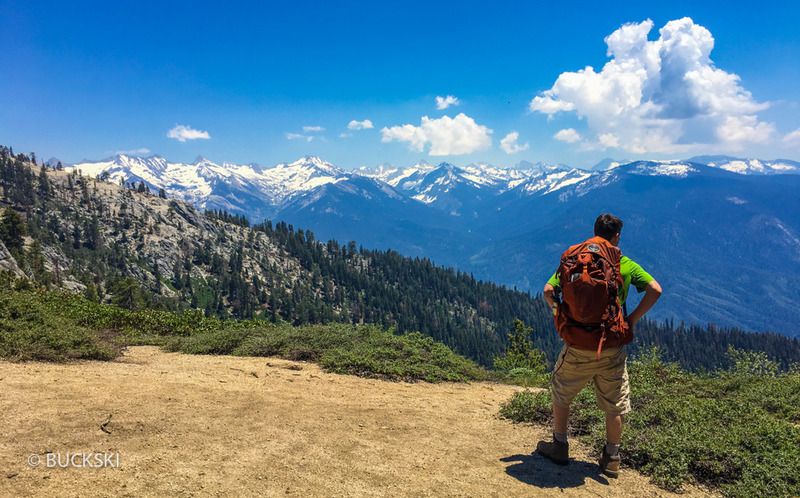
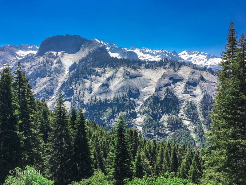
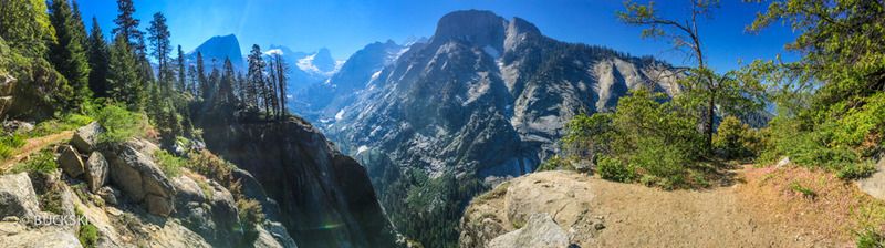
Summer Solstice 2017- Drove to Wolverton 6/20/17, Tuesday AM, lazy noon start, started hiking the Alta trail to Panther Gap- uphill a ways, another warm day but don’t recall it feeling as bad as the elevation profile makes it look. 1h:45m later, a great reveal of the big views cresting near Panther Peak and the Kaweah watershed, then dropping down 1,400ft/3.4 mi where we hit the High Sierra Trail on the East side of Mehrten Creek- the Alta trail crosses various tributaries of Mehrten creek, 2-3 of them were ankle deep across the trail for several steps, so we found places to jump across only 2-3 ft. wide.
Creek Crossings on High Sierra Trail 6/19/2017
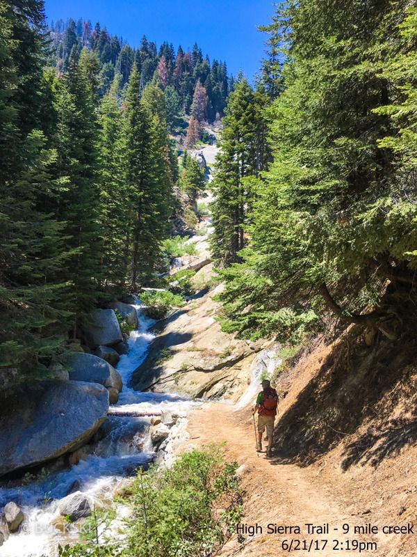
Joined the HST from Alta Trail almost 5pm, 2 main creeks between Alta trail junction (near Merhrten) and “Little Blue Dome” (feature on map) were passable with boots on. First was 12” deep and quick- had boulder hop directly across trail, second one very swift moving water under a triple log bridge crossing (looks built by park service?) – steep drop-off downstream, was a zero room for error crossing. We reach 9-mile creek at 6:15pm, peak flow, it is thigh-deep across the trail- put on our river-shoes, I recall a trip report showing the approach which is immediately upstream of the 15-foot pine log jammed across the pool along trail, one hand on the log, one pole on the ground, mostly gravel with a boulder on the end, water up to high-thigh, crotch and wasn’t much less at 2pm the next day. Would have loved to see the pack-horses here! We reached Buck Creek at 7:25p, probably should have made camp, but headed to Bearpaw. Buck Creek probably the riskiest crossing all day, though it has a bridge, the cement landing approaching the bridge was flooded draining over a granite slab into cascading rapids of whitewater. Several boulders just above water connected a tent size boulder from which it was an easy hop down to the dry bridge- boots on, stable footing across, not very technical, BUT a mistake/slip here would have quickly become a scary ordeal that would have been lucky to not end with a head injury or drowning. Important to note: There are basic swift water crossing techniques, knowing the basics is a minimum for safety and using judgment to match your comfort/assess risk.
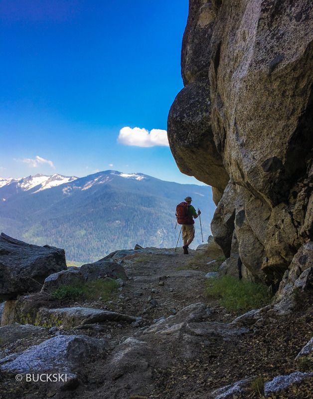
Mosquitoes were a nuisance, small campfire helped, long first day, +/- 12 miles. Woke up the next morning (Wednesday) at Bearpaw Meadow backpacker camp, not SEKI’s finest campsite for hanging around- butif you make it that far, at least drop your pack and hike another mile or two towards Lone Pine Creek, it would be a shame to not see the Hamilton Lake basin(won’t be high enough to see Hamilton Lake directly, but views of the Western Divide are encapsulating!). We carried light provisions 1.8 mi. along a wonderfully engineered section of the HST, had breakfast and coffee near Lone Pine creek on a granite boulder in the shade, enjoyed the view of tall granite mountains, all around, junipers, pines, shady maples, melting snow, was a hot morning sun and we turned around. It would have been 8 miles return to see Hamilton Lake- wanted to do it for a day-hike since we didn’t have time to camp there, but reports of water flowing out of Hamilton was dangerous, swift, fast, “we turned back”, “we went for it but it was sketchy”, “we looked at it for 15 minutes both coming and going before we crossed” is what we were hearing, but we kept seeing people come and go from Hamilton including a guy from Bearpaw High Sierra camp heading for a 8-pitch 5.9 route up a dome, then saw more young rock climbers later that day too.
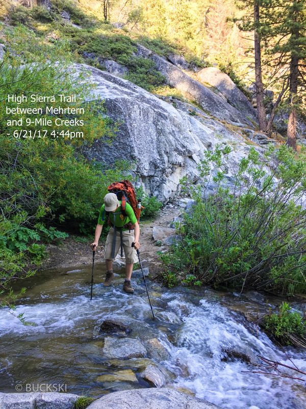
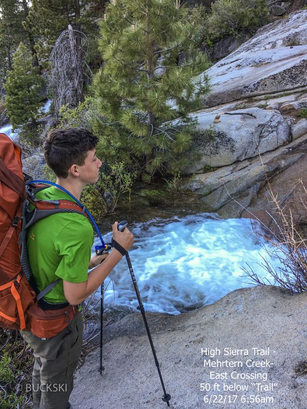
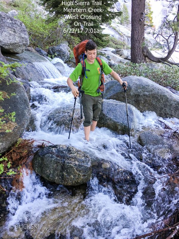
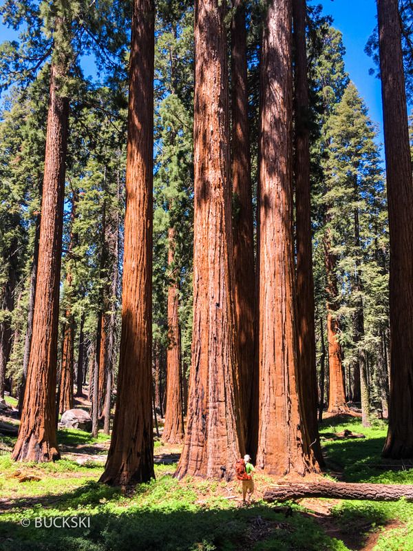
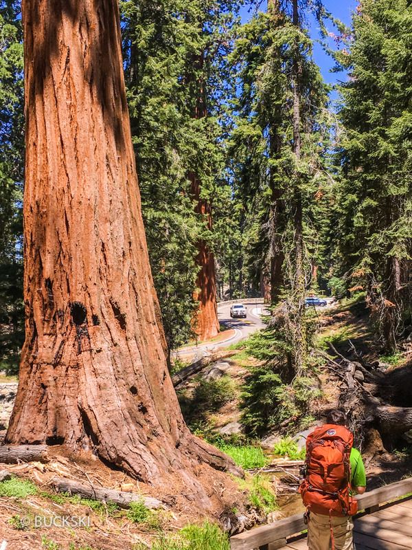
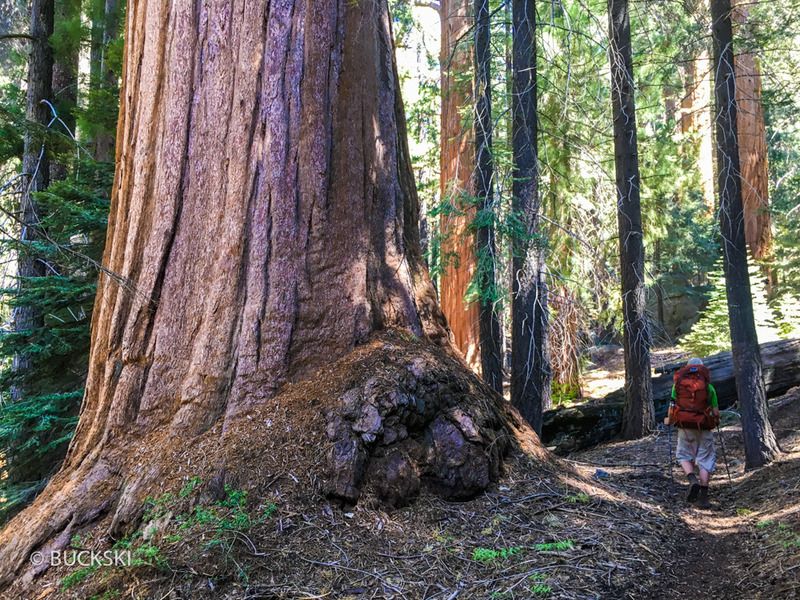
Took our time rest of the day, plan was to camp at Mehrtern Creek. We bathed, cooled off, and pumped water at Buck Creek. No rush for a short day hike. Apparently no campsites East of Mehrtern Creek (oops), plan was to cross early in the morning at low-flow. Hard to find a place for bear can that it woudn’t roll off a cliff if pawed at. Two crossings at Mehrtern Creek within 200 feet of eachother. East Crossing was a knee deep pool 50 ft downstream of trail, about 6 ft. across. West crossing was ankle-knee deep but about 30 feet across and COLD, we crossed both before 7am- finally off to an early and cool start. Hiked 3 miles in the cool morning air to the Wolverton Cutoff in 90-min. Decided to go up that hill to change the scenery and end the hike in the Giant Forest instead of the common Crescent Meadow. Great decision! Saw 2 riders and 8 pack horses at the trail crest, then 4 miles of Giant Sequoia’s with no other humans to be seen until we met Congress Trail. This became a victory lap for my nephew, with his big dusty backpack, and looks from recently showered walkers wondering where we came from. We waited 5 minutes by the General Sherman tree and hoards of mid-day tourists and a park-shuttle drove us back to Wolverton. Had a burger at the River View in Three Rivers and hit the road home, still 113º in the valley!
1
2
3
4
5
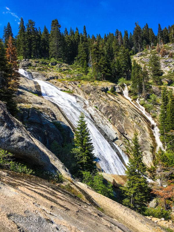
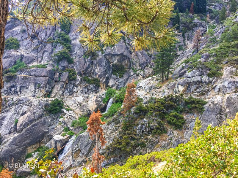
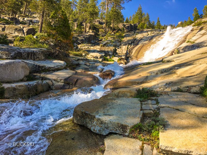
6. Waterfalls above 9-mile creek. A very short trail blaze for fantastic views (stay 100 ft. back from creek for easy route).
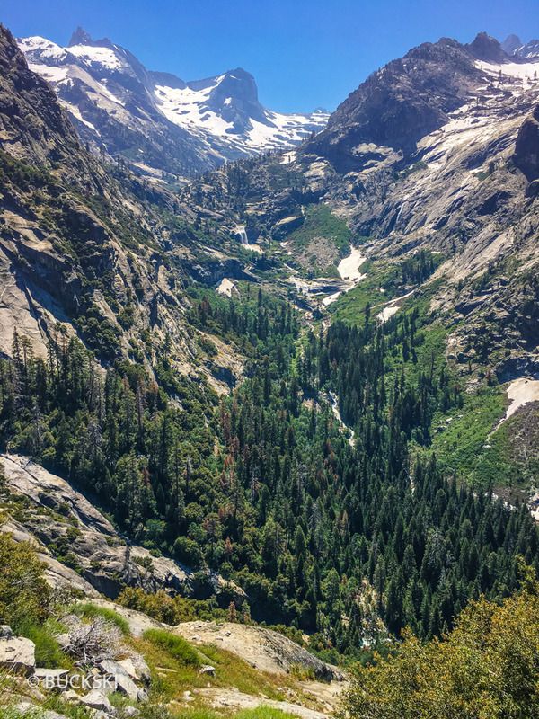
7. Lone Pine Creek - Mt. Stewart 12,025 ft.
8
9
10
11
12
13
14
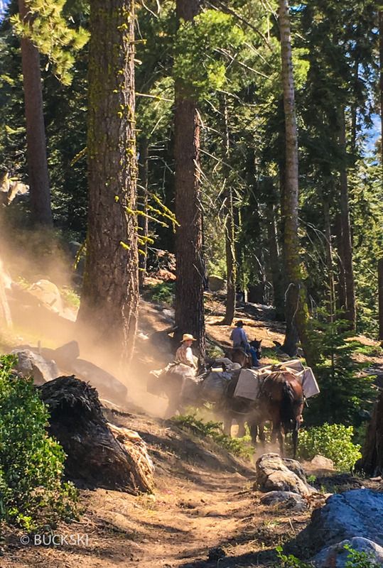
Pack Horses- to Bearpaw and back in one day via Wolverton Cutoff
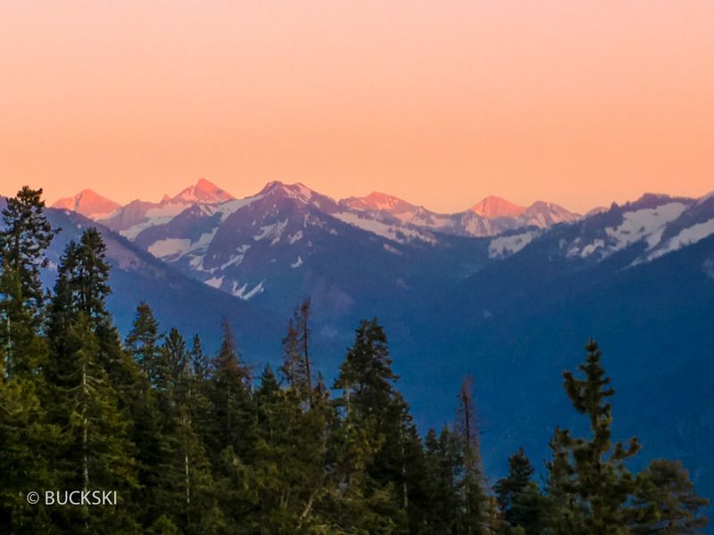
Some nice AlpenGlow on our last night
Regarding Creek Crossings, It’s very hard to explain risk level and “perceived” danger; several creek crossings were a perilous threat for certain, risky- yes, reckless- not quite, but not much room for error just like rock climbing or skiing, a small mistake can be catastrophic. Comfort/risk/danger is relative and subjective to a certain point. Here’s how the trip went:
High Temperatures throughout the area for several days leading up to our hike, 113º near Visila and 109º at Buckey Flat near the park entrance as we drove in! This meant maximum snow-melt… Came into Lodgepole via Hwy-198 (Three Rivers), talked to the ranger before she closed the backcountry permit desk at 4pm (Visitor Center open till 4:30) and we decided against starting that evening on the HST- All creeks running very high, Reports of Mehrtern Creek sounding like the biggest obstacle. Decided to start the next morning (Tuesday) on a modified approach to the High Sierra Trail. Found (free) dispersed camping near Buck Rock Lookout on 4wd trail- very cool.
Summer Solstice 2017- Drove to Wolverton 6/20/17, Tuesday AM, lazy noon start, started hiking the Alta trail to Panther Gap- uphill a ways, another warm day but don’t recall it feeling as bad as the elevation profile makes it look. 1h:45m later, a great reveal of the big views cresting near Panther Peak and the Kaweah watershed, then dropping down 1,400ft/3.4 mi where we hit the High Sierra Trail on the East side of Mehrten Creek- the Alta trail crosses various tributaries of Mehrten creek, 2-3 of them were ankle deep across the trail for several steps, so we found places to jump across only 2-3 ft. wide.
Creek Crossings on High Sierra Trail 6/19/2017
Joined the HST from Alta Trail almost 5pm, 2 main creeks between Alta trail junction (near Merhrten) and “Little Blue Dome” (feature on map) were passable with boots on. First was 12” deep and quick- had boulder hop directly across trail, second one very swift moving water under a triple log bridge crossing (looks built by park service?) – steep drop-off downstream, was a zero room for error crossing. We reach 9-mile creek at 6:15pm, peak flow, it is thigh-deep across the trail- put on our river-shoes, I recall a trip report showing the approach which is immediately upstream of the 15-foot pine log jammed across the pool along trail, one hand on the log, one pole on the ground, mostly gravel with a boulder on the end, water up to high-thigh, crotch and wasn’t much less at 2pm the next day. Would have loved to see the pack-horses here! We reached Buck Creek at 7:25p, probably should have made camp, but headed to Bearpaw. Buck Creek probably the riskiest crossing all day, though it has a bridge, the cement landing approaching the bridge was flooded draining over a granite slab into cascading rapids of whitewater. Several boulders just above water connected a tent size boulder from which it was an easy hop down to the dry bridge- boots on, stable footing across, not very technical, BUT a mistake/slip here would have quickly become a scary ordeal that would have been lucky to not end with a head injury or drowning. Important to note: There are basic swift water crossing techniques, knowing the basics is a minimum for safety and using judgment to match your comfort/assess risk.
Mosquitoes were a nuisance, small campfire helped, long first day, +/- 12 miles. Woke up the next morning (Wednesday) at Bearpaw Meadow backpacker camp, not SEKI’s finest campsite for hanging around- butif you make it that far, at least drop your pack and hike another mile or two towards Lone Pine Creek, it would be a shame to not see the Hamilton Lake basin(won’t be high enough to see Hamilton Lake directly, but views of the Western Divide are encapsulating!). We carried light provisions 1.8 mi. along a wonderfully engineered section of the HST, had breakfast and coffee near Lone Pine creek on a granite boulder in the shade, enjoyed the view of tall granite mountains, all around, junipers, pines, shady maples, melting snow, was a hot morning sun and we turned around. It would have been 8 miles return to see Hamilton Lake- wanted to do it for a day-hike since we didn’t have time to camp there, but reports of water flowing out of Hamilton was dangerous, swift, fast, “we turned back”, “we went for it but it was sketchy”, “we looked at it for 15 minutes both coming and going before we crossed” is what we were hearing, but we kept seeing people come and go from Hamilton including a guy from Bearpaw High Sierra camp heading for a 8-pitch 5.9 route up a dome, then saw more young rock climbers later that day too.
Took our time rest of the day, plan was to camp at Mehrtern Creek. We bathed, cooled off, and pumped water at Buck Creek. No rush for a short day hike. Apparently no campsites East of Mehrtern Creek (oops), plan was to cross early in the morning at low-flow. Hard to find a place for bear can that it woudn’t roll off a cliff if pawed at. Two crossings at Mehrtern Creek within 200 feet of eachother. East Crossing was a knee deep pool 50 ft downstream of trail, about 6 ft. across. West crossing was ankle-knee deep but about 30 feet across and COLD, we crossed both before 7am- finally off to an early and cool start. Hiked 3 miles in the cool morning air to the Wolverton Cutoff in 90-min. Decided to go up that hill to change the scenery and end the hike in the Giant Forest instead of the common Crescent Meadow. Great decision! Saw 2 riders and 8 pack horses at the trail crest, then 4 miles of Giant Sequoia’s with no other humans to be seen until we met Congress Trail. This became a victory lap for my nephew, with his big dusty backpack, and looks from recently showered walkers wondering where we came from. We waited 5 minutes by the General Sherman tree and hoards of mid-day tourists and a park-shuttle drove us back to Wolverton. Had a burger at the River View in Three Rivers and hit the road home, still 113º in the valley!
Of course- some Scenery Shots:
1
2
3
4
5
6. Waterfalls above 9-mile creek. A very short trail blaze for fantastic views (stay 100 ft. back from creek for easy route).
7. Lone Pine Creek - Mt. Stewart 12,025 ft.
8
9
10
11
12
13
14
Pack Horses- to Bearpaw and back in one day via Wolverton Cutoff
Some nice AlpenGlow on our last night