R04/T01 TR: Enchanted Gorge, July 24-29, 2016
Posted: Mon Aug 15, 2016 11:22 am
TR: Enchanted Gorge, July 24-29, 2016
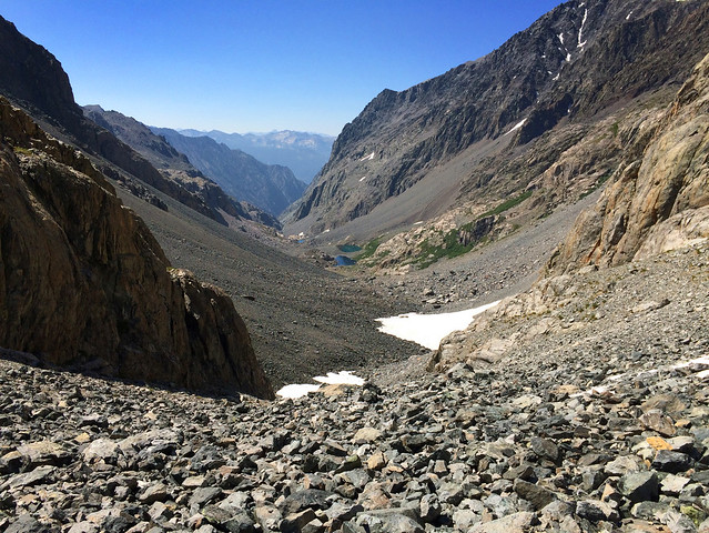
Inspired by Homer's Odyssey and Bill Finch's trip report: http://www.sierrahiker.com/EnchantedGorge/index.html, I did a six day solo trip of the Enchanted Gorge, starting at Courtwright Reservoir, over Hell For Sure Pass, down the Enchanted Gorge, up Goddard Creek, and out over Finger Col. Bill's trip report and a map were the sum total of my research for the hike. One of the things I liked best about Bill's description is that it wasn't too detailed. There were no "How-to's" and "Go this way's". It was general enough so that, following his route, I could make my own mistakes and solve my own dilemnas.
The difficulty of the most challenging part, the descent through the Enchanted Gorge's lower two-thirds, is clearly very dependent on that year's climate, time of year, snow conditions, and stream conditions. I was lucky that I didn't have any snow bridges to go over, but I did have to deal with a stream too deep to cross in most places, cliffs, and talus so steep that it often slid. And in the lower Gorge, I had to beat through thick vegetation and meet the famous stinging nettles.
The return, up Goddard Creek, made up for any disenchantment I suffered in the Gorge. Goddard Creek was everything the Enchanted Gorge was not. The creek was shallow, there are many cascades and step-pools, and its easy to walk alongside or in the creek. Until that one moment it's not, but that's in the details....
My write-up of the trip is here: http://www.jeannepanek.com/mountains-an ... nted-gorge
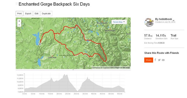
Trip Map and elevation profile:
Inspired by Homer's Odyssey and Bill Finch's trip report: http://www.sierrahiker.com/EnchantedGorge/index.html, I did a six day solo trip of the Enchanted Gorge, starting at Courtwright Reservoir, over Hell For Sure Pass, down the Enchanted Gorge, up Goddard Creek, and out over Finger Col. Bill's trip report and a map were the sum total of my research for the hike. One of the things I liked best about Bill's description is that it wasn't too detailed. There were no "How-to's" and "Go this way's". It was general enough so that, following his route, I could make my own mistakes and solve my own dilemnas.
The difficulty of the most challenging part, the descent through the Enchanted Gorge's lower two-thirds, is clearly very dependent on that year's climate, time of year, snow conditions, and stream conditions. I was lucky that I didn't have any snow bridges to go over, but I did have to deal with a stream too deep to cross in most places, cliffs, and talus so steep that it often slid. And in the lower Gorge, I had to beat through thick vegetation and meet the famous stinging nettles.
The return, up Goddard Creek, made up for any disenchantment I suffered in the Gorge. Goddard Creek was everything the Enchanted Gorge was not. The creek was shallow, there are many cascades and step-pools, and its easy to walk alongside or in the creek. Until that one moment it's not, but that's in the details....
My write-up of the trip is here: http://www.jeannepanek.com/mountains-an ... nted-gorge
Trip Map and elevation profile: