I am planning a circuit through Yosemite in late July, part of the purpose is discussed elsewhere on this forum. The general route:
1) Leaving from Mono Meadows
2) Illilouette Creek to Merced pass lakes and Ottaway lakes
3) Over Red Peak Pass to Red Devil lake or vicinity
4) Over to the the high trail above Triple Peak Fork and camp somewhere along it
5, 6) Cross x up the Lyell fork for a couple of nights camping with friends
7) Out via Merced to Happy Isles, possibly stopping for a night to break up the exit.
I have several questions
a) On the first day in we (I am bringing a friend) will get a late start from Mono Meadows--perhaps 2pm. Do we have to make it all the way to Illilouette Creek to get a reasonable campsite with water? Are there any other good options? I wonder how long it will take to get to Illilouette. We won't be fast on our first day from sea level.
b) Is Lower Ottaway a good destination for our second night? It looks the most interesting of the lakes from the maps. How is the camping there?
c) How about Red Devil for the 3rd night. It looks very interesting on the map and seems like it would be worth a night to explore a bit. But I've never heard a thing about it, and it will be slightly off trail.
d) Once we get up on the east side of Triple Peak Fork, we will need another good destination for a night. Anyone been to the little lake just north of Foerster Creek and slightly off trail? (Harriet Lake is going to be a little too far off trail for us at that point.)
e)As we hike out past Merced lake and get down to the throngs in Little Yosemite Valley, I'm undecided as to whether to just hike out through all of it or to spend one night on the trail to break it up. If we spend the night, what are the options between the Merced High Sierra Camp and Little Yosemite Valley? I've never hiked this popular area.
Many thanks in advance for your expert advice!
Planning my Clark Range circuit
-
kpeter

- Topix Fanatic
- Posts: 1466
- Joined: Mon Jan 04, 2010 1:11 pm
- Experience: Level 3 Backpacker
-
TehipiteTom

- Founding Member
- Posts: 955
- Joined: Thu Aug 24, 2006 8:42 am
- Experience: Level 4 Explorer
Re: Planning my Clark Range circuit
a) Illilouette Creek isn't far (maybe 3 miles?), and it is nearly all downhill. I'd go ahead and shoot for that for your first day, which sets you up for getting to Ottoway in a reasonable second day.
b) Beautiful lake, and while I haven't camped there, when I hiked past it I saw what looked like some good campsites.
c) Red Devil is one of my favorite lakes in the area--beautiful, wide-open views, definitely worth the detour. The off-trail portion isn't difficult at all.
b) Beautiful lake, and while I haven't camped there, when I hiked past it I saw what looked like some good campsites.
c) Red Devil is one of my favorite lakes in the area--beautiful, wide-open views, definitely worth the detour. The off-trail portion isn't difficult at all.
-
oldranger

- Topix Addict
- Posts: 2871
- Joined: Fri Jan 19, 2007 9:18 pm
- Experience: N/A
- Location: Bend, Oregon
Re: Planning my Clark Range circuit
What Tom said and I would probably not worry about camping near a lake between Triple Divide and Lyle Fork. It would not be reasonable for me to hike all the way from the Lyle Fork to the Valley in a day. Not sure what sites are like between Merced lake and Little Yosemite after the latest fire. Do remember some sites near Bunnell Cascade. I have done the 14 miles between Merced Lake and the valley in a day so that is certainly doable, too.
Great trip but would be better with a couple more layover days!
Mike
Great trip but would be better with a couple more layover days!
Mike
Mike
Who can't do everything he used to and what he can do takes a hell of a lot longer!
Who can't do everything he used to and what he can do takes a hell of a lot longer!
-
maverick

- Forums Moderator

- Posts: 12111
- Joined: Thu Apr 06, 2006 5:54 pm
- Experience: Level 4 Explorer
Re: Planning my Clark Range circuit
As TT mentioned the hike from Mono to Illilouette is easy, there are campsites all along Illilouette Creek some good ones where the trail crosses the Clark Fork and Red Creek.I have several questions
a) On the first day in we (I am bringing a friend) will get a late start from Mono Meadows--perhaps 2pm. Do we have to make it all the way to Illilouette Creek to get a reasonable campsite with water? Are there any other good options? I wonder how long it will take to get to Illilouette. We won't be fast on our first day from sea level.
b) Is Lower Ottaway a good destination for our second night? It looks the most interesting of the lakes from the maps. How is the camping there?
c) How about Red Devil for the 3rd night. It looks very interesting on the map and seems like it would be worth a night to explore a bit. But I've never heard a thing about it, and it will be slightly off trail.
d) Once we get up on the east side of Triple Peak Fork, we will need another good destination for a night. Anyone been to the little lake just north of Foerster Creek and slightly off trail? (Harriet Lake is going to be a little too far off trail for us at that point.)
e)As we hike out past Merced lake and get down to the throngs in Little Yosemite Valley, I'm undecided as to whether to just hike out through all of it or to spend one night on the trail to break it up. If we spend the night, what are the options between the Merced High Sierra Camp and Little Yosemite Valley? I've never hiked this popular area.
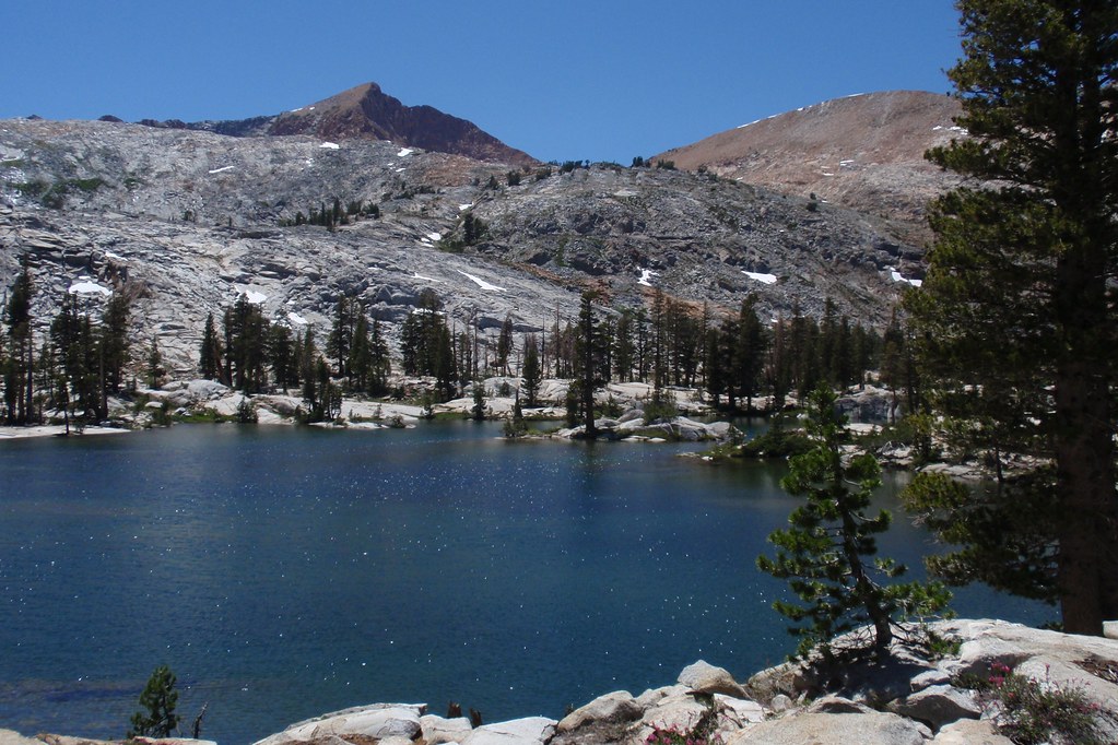
Lower Ottaway is very pretty and good camping available.
Red Devil will be one of the highlights of your trip, my favorite on your planned trip to the Meet-up.
Do not stay at LLV, stay near Bunnell Cascade before descending into Lost Valley.
Professional Sierra Landscape Photographer
I don't give out specific route information, my belief is that it takes away from the whole adventure spirit of a trip, if you need every inch planned out, you'll have to get that from someone else.
Have a safer backcountry experience by using the HST ReConn Form 2.0, named after Larry Conn, a HST member: http://reconn.org
-
maiathebee

- Topix Expert
- Posts: 471
- Joined: Tue Jun 18, 2013 11:59 am
- Experience: Level 4 Explorer
- Location: Alpine Meadows, CA
- Contact:
Re: Planning my Clark Range circuit
I did a similar route in 2014. You can read about it here if you want: https://plutoniclove.com/2014/07/24/sou ... berg-pass/. It's a super beautiful area that doesn't get much traffic. You're going to have an awesome time! Especially on the High Trail portion around the Lyell Fork. Stunning area.
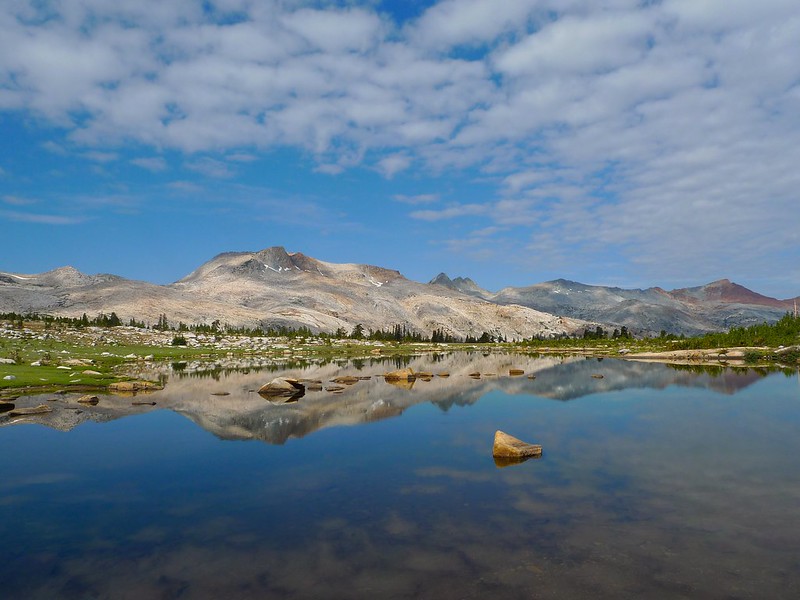 Cloud-dappled morning sun at the lakes west of Isberg Pass by Maia Averett, on Flickr
There is an absolutely baller campsite just north of the Lyell Fork as you hike out along the trail. I so wish I had known about it and camped there. It's on a little ledge at the first stream you cross as you head north out of Lyell Fork. You get your own personal little waterfall and absolutely stunning views:
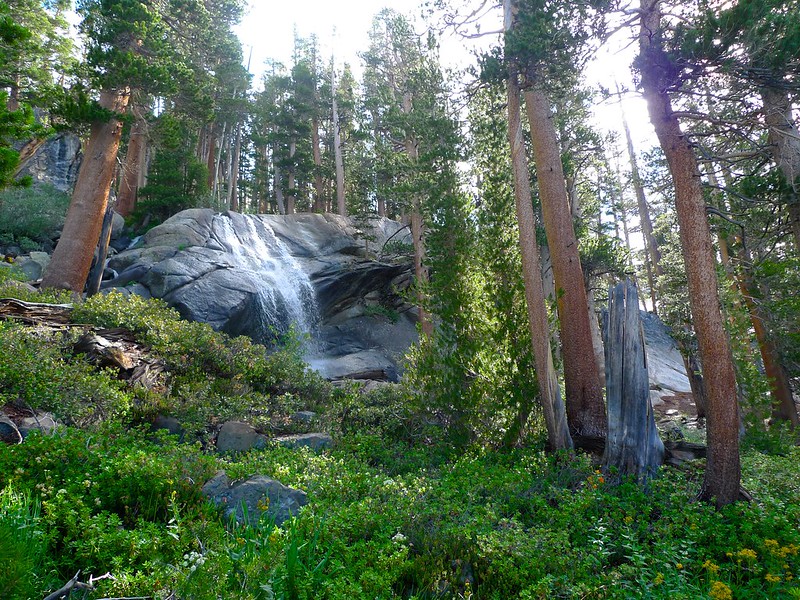 Waterfall on the High Trail between Isberg Pass and Vogelsang by Maia Averett, on Flickr
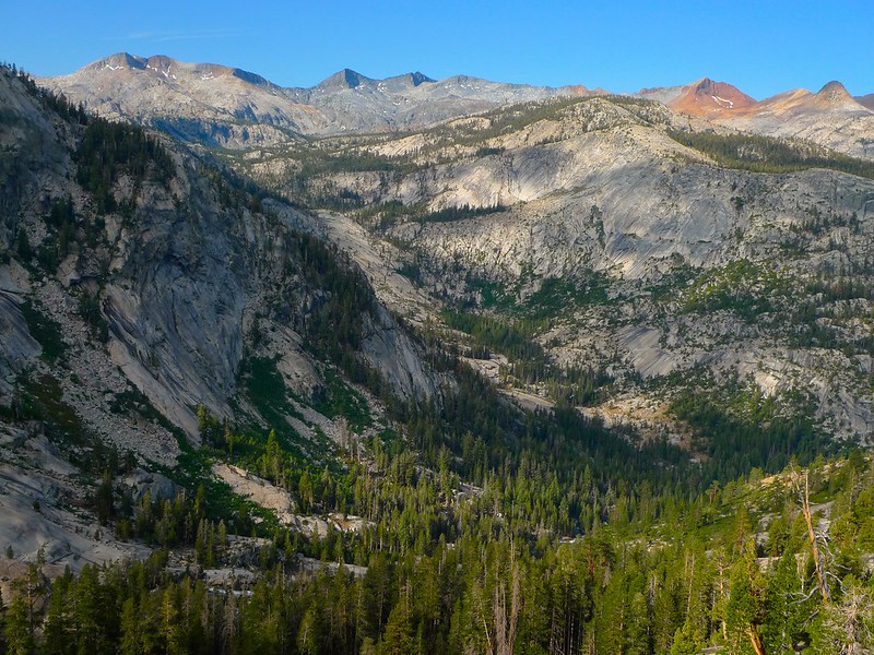 Morning sun on the Clark Range as seen from the Lyell Fork of the Merced by Maia Averett, on Flickr
I've not, but most of that area is wooded where the trail is. If you want to camp with views, I'd either stop at the lakes just below Isberg Pass or go ahead and push forward to the Lyell fork.kpeter wrote:
d) Once we get up on the east side of Triple Peak Fork, we will need another good destination for a night. Anyone been to the little lake just north of Foerster Creek and slightly off trail? (Harriet Lake is going to be a little too far off trail for us at that point.)
Cloud-dappled morning sun at the lakes west of Isberg Pass by Maia Averett, on FlickrThere is an absolutely baller campsite just north of the Lyell Fork as you hike out along the trail. I so wish I had known about it and camped there. It's on a little ledge at the first stream you cross as you head north out of Lyell Fork. You get your own personal little waterfall and absolutely stunning views:
Waterfall on the High Trail between Isberg Pass and Vogelsang by Maia Averett, on FlickrMorning sun on the Clark Range as seen from the Lyell Fork of the Merced by Maia Averett, on FlickrThere aren't a lot of options. Like mav said, there are some sites near the Bunnell Cascade. When I hiked through they were all taken. I ended up snagging an established spot at the very east end of LYV, which I'm 80% sure is legal.kpeter wrote: e)As we hike out past Merced lake and get down to the throngs in Little Yosemite Valley, I'm undecided as to whether to just hike out through all of it or to spend one night on the trail to break it up. If we spend the night, what are the options between the Merced High Sierra Camp and Little Yosemite Valley? I've never hiked this popular area.
oh hey! you're reading my signature.
that's nice. want to check out my blog?
here it is: plutoniclove.com
ig: @plutonic_love
that's nice. want to check out my blog?
here it is: plutoniclove.com
ig: @plutonic_love
-
kpeter
- Topix Fanatic
- Posts: 1466
- Joined: Mon Jan 04, 2010 1:11 pm
- Experience: Level 3 Backpacker
Re: Planning my Clark Range circuit
My goodness, ask and ye shall receive. Terrific advice from all of you, and a detailed trip report to boot. Gorgeous pictures. Thank you all for the excellent work preparing me!
-
oliverlu

- Topix Novice
- Posts: 7
- Joined: Fri May 10, 2013 1:46 pm
- Experience: N/A
Re: Planning my Clark Range circuit
We just came back from that loop. Started from GP, took the Panorama trail and the high route (past Mt Starr King) up the Pass, and the "low water route" past the HSC back to the Valley.
- If you leave at 2pm, you should easily make it to Mono Meadow/Illilouette. Next reliable water should be at Clark Fork/Red Creek (there are some nice spots near there) or further along the Illillouette. (there are a couple bears in that area) (The smaller creeks below Clark Fork were already dry).
- Lower Ottoway is nice, but there is a shelf above the lake where you overlook the lake and get to enjoy a nice sunset.
- The other side of Red Peak Pass is still holding a lot of snow (over 5ft). Most should be melted out in a month.
. Red Devil Lake is really nice. Not too far off trail, and easy to get to.
- Triple Peak Fork has some nice spots. We didn't do the high water trail, but listened to first-hand reports of it being still very wet, with massive swarms of mosquitos. The top of the switchbacks north of Triple Peak Fork crossing (along the low water trail) has a couple of amazing spots next to a nice waterfall.
- Echo Valley has a couple of camp spots, and there are some at the twin bridges before the Bunnell Cascade. There's a large trail crew living there now, but they may have moved on before your trip. From there nothing until the east end of LVY, but that area is all burned out now to the edge of the LVY camp. First-hand reports of a nightly mini paint-ball war between the rangers and bears from those that stayed there.
-
kpeter
- Topix Fanatic
- Posts: 1466
- Joined: Mon Jan 04, 2010 1:11 pm
- Experience: Level 3 Backpacker
Re: Planning my Clark Range circuit
Due to the logistics issues with the tour bus, I am considering turning this into a full loop trip from Mono Meadows. That would mean adding the section from Nevada Falls up out of the canyon and over to Illouette Creek then back up to Mono Meadows from Illouette Creek. Has anyone done this section? We'd probably be trying to get from Bunnel Cascades to Mono Meadows on the last day--with light packs of course and fully acclimated. Is this reasonable?
-
oliverlu
- Topix Novice
- Posts: 7
- Joined: Fri May 10, 2013 1:46 pm
- Experience: N/A
Re: Planning my Clark Range circuit
Going from Bunnell to Mono Meadows in a day is definitely doable especially since you'll have been acclimated. Just note that the stretch from Nevada Falls to the Illilouette crossing will be dry and that there's not much shade past the junction of the Panorama trail.
If you are still trying to get the bus, there's a 24 hr cancellation notice w/o charge, so spots tend to open up closer to departure. Also, sometimes they add another bus, so it doesn't hurt to periodically check their website.
If you are still trying to get the bus, there's a 24 hr cancellation notice w/o charge, so spots tend to open up closer to departure. Also, sometimes they add another bus, so it doesn't hurt to periodically check their website.
-
maverick
- Forums Moderator
- Posts: 12111
- Joined: Thu Apr 06, 2006 5:54 pm
- Experience: Level 4 Explorer
Re: Planning my Clark Range circuit
It is about 12.5 miles from Bunnell to Mono using the trail that goes up past Panorama Point on its eastern side (little steep), you will have to load up on water right after Nevada Falls, this trail will cut your mileage by 1.6 miles, using the Panorama Trail and then up Illilouette Creek will get you to water after about 3 miles as opposed to 4 miles, but is 1.6 miles longer.Due to the logistics issues with the tour bus, I am considering turning this into a full loop trip from Mono Meadows. That would mean adding the section from Nevada Falls up out of the canyon and over to Illouette Creek then back up to Mono Meadows from Illouette Creek. Has anyone done this section? We'd probably be trying to get from Bunnel Cascades to Mono Meadows on the last day--with light packs of course and fully acclimated. Is this reasonable?
Would rather personally use the shorter route, last thing I want to see is loads of people on the Panorama Trail as I am heading out.
Professional Sierra Landscape Photographer
I don't give out specific route information, my belief is that it takes away from the whole adventure spirit of a trip, if you need every inch planned out, you'll have to get that from someone else.
Have a safer backcountry experience by using the HST ReConn Form 2.0, named after Larry Conn, a HST member: http://reconn.org
I don't give out specific route information, my belief is that it takes away from the whole adventure spirit of a trip, if you need every inch planned out, you'll have to get that from someone else.
Have a safer backcountry experience by using the HST ReConn Form 2.0, named after Larry Conn, a HST member: http://reconn.org
Who is online
Users browsing this forum: C_S, Google Adsense [Bot], Schleppy, Slepak and 11 guests