If you've been searching for the best source of information and stimulating discussion related to Spring/Summer/Fall backpacking, hiking and camping in the Sierra Nevada...look no further!
I've seen this topic on another forum, and thought it might be fun to get started here. The rules are simple: identify the spot of the posted photo. If you get it right, you are next up to post a photo of a beloved place you've visited.
This is a great way for all of us to see cool photos of wonderful places, and learn a bit more about the great destinations there are in our wilderness.
And here's a photo to start--I don't think this one will be too hard:
If you think you know where this is, give it a shot! And no fair following the link!
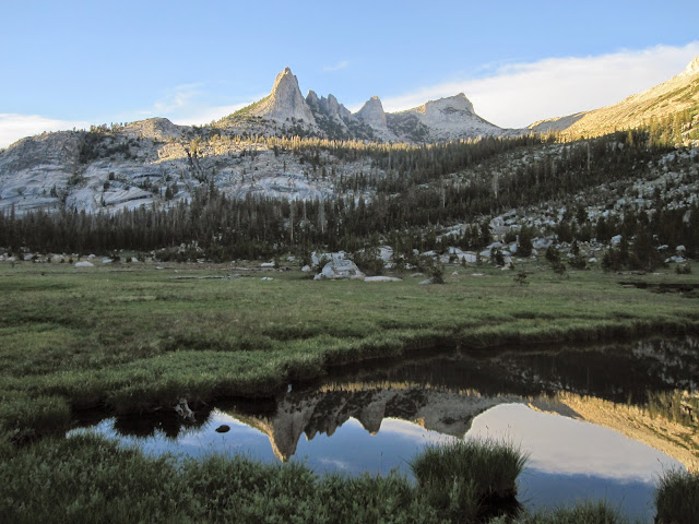
Check the center crosshairs above. Am guessing camera position is the northeast corner of Echo Lake at the crosshairs where a tiny grass hummock peninsula juts out so a photographer can get behind a small edge of calm water. One can see a boulder in the meadow right in line with the center of Echo Peaks that matches a rock on the above satellite image. Also if one switches to the topo map tab and places a straight edge between that crosshairs point and the center of Echo Peaks it appears to show in the background image the point on the map at the base of where the stream draining that slope at 9600 feet just begins a steeper gradient. That eliminates the camera position from possibly being at one of the meadow turf ponds.
A location for a person wearing shorts and t-shirt to sucked into looking like a shriveled raisin by mid June mosquitoes.
Daisy, you are oh so close. But SSSDave his it right on the money. Those are Echo Peaks (Matthes Crest is just out of view to the right in this photo). And happily, because this was later in the season, there weren't TOO many skeeters in evidence.
SSS Dave, you are up! Post a photo and see if we can guess where it is.
Will do so this evening after this m-f 8-5 working person goes home.
It would be easy for anyone to post mountain pictures that no one could guess. For example images of some shallow no-name pond in the forest away from trails without any recognizable features. Thus anyone posting an image MUST include features that can possibly be recognized. I ramble many places off trail that I could post photos of some little no name ridge line or peak and likewise no one would probably be able to identify where such was. For instance landscapes where giantbrookie and I made trips through near Hoffman Mountain on our ways to White Divide. The object is not to post something that no one will identify but rather something with clues fair numbers of members have probably seen but won't easily recognized making a worthwhile game.
Also if after a day or three no one gets anywhere, the poster ought to start providing some clues like the region.
contains quite a few images taken from unknown vaguely described locations as well as many well identified. This is an easy one. Most will instantly know the region and several more will know the basin even before looking at a map. Identifying the lakes will not take too much time. But who can identify the approximate camera position? The Balzaccom puzzle was at these crosshairs.
But they who can answer this one by using Acme map likewise, thus providing a link, will be the next postee.
(mouse select to zoom a bit)
Note the crosshairs remain at the same exact spot while switching between map tabs. And the map key at lower right contains a button "Link to this page". One must actuate that button to change the URL link to the crosshairs position else the URL in the browser address bar does not change while moving the map.