Page 1 of 1
Sierra High Route Loop
Posted: Wed Jun 10, 2015 6:08 pm
by jgaffney
I read Steve Roper's book on his alternative to the JMT. I don't have time to hike the whole trail, but I dreamed up this loop.
First, some info on me. I'm an experienced backpacker who's not afraid to hike solo in the wilderness. I'm more than adept with GPS and map-and-compass route-finding. I'm comfortable with overland travel and Class-3 scrambling. If I do this loop, I'll check in with the resident ranger at Thousand Island Lake before heading west.
Here's a general description: Hike from Tuolumne Meadows down to Thousand Island Lake. Then, leaving the JMT, hike southwest over North Glacier Pass to Twin Island Lakes, west to Blue Lake and over Blue Lake Pass, and continue west to the High Trail along the rim of the Merced River Canyon. Then, hike north through Lewis Creek, up over Vogelsang Pass, and back to Tuolumne Meadows along Rafferty Creek.
Here's a trail map:
http://i166.photobucket.com/albums/u90/ ... okc16n.jpg
All of this seems doable except for the descent from Lake Catherine across the canyon to Twin Island Lakes. Roper cautions about the Class 3 terrain in this reach but, after looking at it in Google Earth, it looks pretty exciting. Does anyone else have any experience in this area?
Thanks for your help.
Re: Sierra High Route Loop
Posted: Wed Jun 10, 2015 6:32 pm
by maverick
Hi JGaffney,
Welcome to HST! There are numerous reports about that section, and some on the entire SHR here on HST, which you can access by using the "search" feature at the top of the Backpacking section. Here is one for example that tackles that precise part of the SHR:
viewtopic.php?f=1&t=9746#p73130
When you get the time, an intro would be appreciated:
viewtopic.php?f=1&t=9329
Re: Sierra High Route Loop
Posted: Thu Jun 11, 2015 2:28 pm
by jgaffney
Maverick, thanks for the reply. The post linked to several other posts with too much info to digest at once. I tried a search here before I posted my message but, obviously, I have to get better at entering search terms. Like, how to use the "+" feature. Thanks again.
Re: Sierra High Route Loop
Posted: Fri Jun 12, 2015 9:58 pm
by Bluewater
- ImageUploadedByTapatalk1434171297.077859.jpg (181.9 KiB) Viewed 1156 times
Welcome to HST. I remember when the conversation that the link leads to was first posted. There are detailed descriptions, photos and maps about the route between Twin Island and Catherine in that post, definitely worth reading. The map above is from WD's description.
Have fun!
Sent from my iPad using Tapatalk
Re: Sierra High Route Loop
Posted: Sat Jun 13, 2015 8:43 am
by Wandering Daisy
The route I took is not the "standard" route described in Roper's book. I explored this area earlier coming up the San Joaquin from Hemlock crossing and ran into remains of an old trail. Because I was familiar with this route, I dropped down from Twin Island Lakes to the trail which is on the hillside. I believe Roper's route stays higher up on the buttresses. His route also crosses Twin Island Lake at the outlet, which is a better choice in a low flow year. I did my route in a higher flow year and being short, I really hate wading waist deep water. The route I took around the other shore of Twin Island Lake is actually harder, but does avoid deep crossings. With this year's low water, I doubt the normal outlet crossing would be difficult. I also wanted to camp in and wander around Ritter Lakes, so my route is not direct nor the standard.
Just plan for sufficient time. The first time I did this route it took me 8 hours to get from the upper Blue Lakes to Twin Island Lake- after some practice, I did it in 4 hours. The route finding is complex with lots of little cliffs, but there are many ways to go and although you may not be super efficient, the problems are solvable by a bit of backtracking if needed. It is an exercise in micro-route finding, one that is not helped by a GPS - depends more on your experience in off-trail travel. On the traverse between Blue Lakes canyon and Twin Island Lake, I found that staying fairly high was better, although a bit more distance. The is no need to get into Class 3 terrain if you are careful about route finding. My main problem were snow patches, hard frozen snow in early morning and high water - this year those obstacles are likely missing.
Re: Sierra High Route Loop
Posted: Sat Jun 13, 2015 9:06 am
by Wandering Daisy
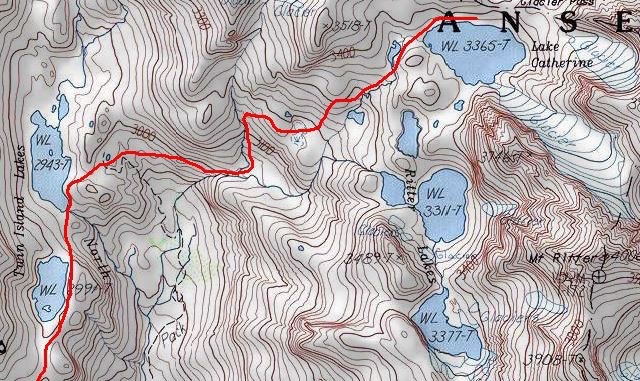
The map that Bluewater shows is a more direct route that I actually took.
Here is the actual route I took. I am not sure exactly where I crossed the shoulder coming up out of Blue Canyon. There is now a cairn that marks the point. From the cairn (going west to east) A very steep use-trail drops about 100 feet to a little drainage. I went up that drainage to get fairly high and traversed high. I went from Blue Lake (not shown on the map below) to the Ritter Lake campsite in one day.
[rimg]http://i249.photobucket.com/albums/gg23 ... oute_2.jpg[/rimg]
Re: Sierra High Route Loop
Posted: Sat Jun 13, 2015 11:36 am
by paul
When I went from Lake Catherine to Twin Island, we stayed higher than either of the two route mapped above, and it was pretty straightforward, certainly no class 3 anywhere. I recall we took off from the outlet of the first pond below Catherine, angled to the right pretty close to the foot of the cliffy stuff, and stayed right of the little know that is between the 3100 and 3200 meter lines on the map, then down a nice ramp and ended up near the inlet end of the lake. Very pleasant. But you can't always see where you want to go due to the shapes of the slopes in there, so you may have to wander around a bit to find the way.
If you have time while you're in there, taking a wander upstream from twin island lakes is very nice.
Re: Sierra High Route Loop
Posted: Tue Nov 17, 2015 7:56 am
by Hobbes
paul wrote:When I went from Lake Catherine to Twin Island, we stayed higher than either of the two route mapped above, and it was pretty straightforward, certainly no class 3 anywhere. I recall we took off from the outlet of the first pond below Catherine, angled to the right pretty close to the foot of the cliffy stuff, and stayed right of the little know that is between the 3100 and 3200 meter lines on the map, then down a nice ramp and ended up near the inlet end of the lake. Very pleasant.
I've seen other references to this route - has anyone else gone this way, or has everyone dropped down into the canyon, then climbed back up to the first Twin island lake?
http://www.mappingsupport.com/p/gmap4.p ... ||line=off
Re: Sierra High Route Loop
Posted: Sat Nov 21, 2015 11:47 am
by oleander
Hobbes wrote:paul wrote:When I went from Lake Catherine to Twin Island, we stayed higher than either of the two route mapped above, and it was pretty straightforward, certainly no class 3 anywhere. I recall we took off from the outlet of the first pond below Catherine, angled to the right pretty close to the foot of the cliffy stuff, and stayed right of the little know that is between the 3100 and 3200 meter lines on the map, then down a nice ramp and ended up near the inlet end of the lake. Very pleasant.
I've seen other references to this route - has anyone else gone this way, or has everyone dropped down into the canyon, then climbed back up to the first Twin island lake?
Karl, you don't need to drop all the way down into the canyon. That adds unnecessary elevation loss, and the regaining of that elevation back up to the Twin Island Lakes looked very steep and not obvious or easy. When you're heading downvalley from Catherine Lake, once you get roughly to the same altitude as the northernmost Twin Island Lake, you can pick up an easy-ish traverse around the canyon headwall by staying level/right. Once you get closer to the northern Twin Island Lake, the terrain gets more convoluted to navigate, but is not technical. Generally you gain about 200 feet above the lake and navigate south, parallel to its eastern shore, till you can descend to its outlet. In the intervening time you may have to drop to its eastern shore once, and regain altitude again, before being able to descend to its outlet.
Rounding the lake is slow going, but still highly preferable (by the looks of it) to the drop-into-the-canyon-and-hike-back-up option.
![[rimg]http://i249.photobucket.com/albums/gg23 ... oute_2.jpg[/rimg]](http://s249.photobucket.com/user/npallister/media/HighRoute2010/Blue%20Canyon%20Route_2.jpg.html)