Page 5 of 8
Re: Adventures With Rogue Photonic 2014 July 8-August 12
Posted: Mon Oct 20, 2014 1:13 pm
by fourputt
For the pedantic version of the record, the USGS 7.5-minute “Tunemah Pass” is a mistake, repeated on Tom Harrison’s Kings Canyon High Country. The actual pass is located 200’ below Point 10987’ as it follows the 19th-century sheepherder trail from Bunch Grass [not so] Flat and drops 5K’ down the ridge to where Goddard Creek enters Simpson Mdw at 6K’.
The “faux” pass no doubt leads to some interesting country and has made for a number of adventures since publication of the 7.5 series ... not that the “real” pass and trail is any kind of reasonable alternative for those headed to Simpson Mdw.
Re: Adventures With Rogue Photonic 2014 July 8-August 12
Posted: Tue Oct 21, 2014 9:01 am
by Cross Country
I taught school and coached after school sports. I didn´t coach my 2 kids little league teams because other dads did. If they hadn´t I would have. I always said ¨thank god there are dads who do this so I don´t have to¨.
I don´t remember ever writing a trip report because to me it´s tedious like coaching little league. Thank you to those of you who write trip reports.
Re: Adventures With Rogue Photonic 2014 July 8-August 12
Posted: Wed Oct 22, 2014 3:36 pm
by alpinemike
The actual pass is located 200’ below Point 10987’
fourputt- If I'm not mistaken this is exactly where the pass is shown to be located on both the Tom Harrison and USGS 7.5 Minute Series Maps. It may be a bit more than 200 ft according to the map I attached. I'm not sure where the pass would be if not there...
Re: Adventures With Rogue Photonic 2014 July 8-August 12
Posted: Wed Oct 22, 2014 7:20 pm
by fourputt
Should've said 200' below Pt 10987 to the south.
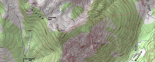
Secor, describing the Tunemah Trail, says "Make a steep ascent to the northeast, climbing over Peak 10,987, which is the real Tunemah 'Pass' (Some maps erroneously place the name on a different saddle 0.4 mile northwest of the peak.)"
You can save a little elevation by not going over the very top, but if you've spent so much effort you might as well enjoy the view.
And it's a surreal feeling camping in remotest Kings Canyon at Bunchgrass Flat and being able to see the lights of Hwy 180 at night.
Re: Adventures With Rogue Photonic 2014 July 8-August 12
Posted: Thu Oct 23, 2014 4:59 pm
by alpinemike
I guess it's a bit odd to call that crossing a pass, since it feels like you're just going over the ridge of the point itself. Regardless, thanks for the clarification. I doubt highly I will ever be in that area ever again.. The prospect of going around Goddard Creek does not entice me one bit..
Re: Adventures With Rogue Photonic 2014 July 8-August 12
Posted: Sat Oct 25, 2014 11:53 am
by alpinemike
Alright fellow readers... Here's Week 4 which continues where we left off immediately after the Enchanted Gorge.
Days 22 & 23 Layover in the Canyon at the Confluence of Goddard & Enchanted Creeks
Since we went down the Enchanted Gorge all in one day we were actually ahead of schedule by a day. So we rested after the utter and total misery of Day 21 in the Gorge. Rogue had planned a layover day in the Gorge itself so we took an extra day of rest just to dry our gear out from the previous days downpour. On Day 22 there was some rain at 4 A.M. which was odd to say the least. It was quite hot and there were plenty of mosquitoes. We practically had a fire all day for drying things out. On Day 23 it was far cooler and it rained during various parts of the day. We also had smoke on both days from some fire but couldn't figure out which direction it came from. The canyon itself is quite picturesque but the prospects of climbing out of it the following day was definitely a damper.
Day 24- Canyon at the Confluence of Goddard & Enchanted Creeks to Lake 10,570 (Below Mt. Woodworth) 3+ Miles
We started the day out no earlier than 9 as we had little more than 3 Miles to go. In an attempt to get away from the awful brush of Goddard Creek we started angling up to 8000 FT on the Northeast side of the canyon. This posed to be a horrendous decision as we had to traverse through a thick oak forest! Yes... Oak at the stupid altitude of around 8000 FT. I could not believe my eyes nor could me feet or body take the pounding of fighting through nearly impenetrable trees! The hill sides were steep and filled with loose rock which only added to the painful climb upwards. We had to lose 150 precious feet just to cross the creek that drained our lakes far above in the drainage. Here we took lunch and prepared for the most grueling climb of our lives. After crossing it was no longer oak to be battled with but willows. Oh.. how I cursed the wretched vegetation! There was nothing one could do but battle and fight their way through it. Not only was the angle impossibly steep but it was very hot.. easily in the 80's with blazing sun. This climbing up the drainage continued for hours on end. It never seemed to end. And of course as we looked across the creek the way was easier with less brush. Unfortunately getting to it meant dropping down and around to cross the creek and fighting through more brush. Eventually we came to the last stretch of brush and what could it be if not the spiky ball brush. I'm not familiar with the scientific name of this plant but the name Rogue and I gave it describes the evil that it gives. The spikes not only hurt but also stung you and stayed latched on until you forcefully took them off. The last misery of the day was a slope of talus so steep one thought he was climbing a vertical wall. It was fortunately fairly stable and we trudged our way up the slope inch by inch. After the entirety of the afternoon was passed we finally reached the bench where our lakes were. We went to the smaller one for it had better camping. The final slope was easily the steepest slope I've ever climbed and Rogue agreed in saying it was the single hardest longest climb he had ever done. It was difficult for me to imagine any worse an experience than the Enchanted Gorge but this came in as a close 2nd. I was physically and mentally exhausted to the point where I collapsed into camp. Somewhere on the order of 3700 FT in just over 1.5 miles is no walk in the park. Thunderheads built all day long but no rain came of it. We enjoyed our dinner amid a gorgeous sunset.
 Viewed 304 times")
- The beautiful granite walls of the canyon of Goddard Creek
 Viewed 296 times")
- Looking towards the mountains North of Cedar Grove the Monarch Divide
 Viewed 302 times")
- Staring down the drainage
 Viewed 302 times")
- The final head-wall to the lakes. The route we took is to the right.
 Viewed 300 times")
- The pretty lake we camped by
 Viewed 298 times")
- A serene landscape
Day 25- Layover
Our plan was to climb Mt. Woodworth but laziness prevailed today. I was still tired from the previous days climb and just wanted the body to rest up. We realized later that we should have climbed Woodworth from that point because it is such a difficult mountain to get to and neither of us wanted to get to this area again. It was a very remote area. The feeling of remoteness was all around. We estimated that very few parties have ever even been in this area for it requires the toil of climbing the drainage that we had climbed out of Goddard Creek. There was not a single sign of an established campsite whatsoever. Lots of clouds built again but no rain. The streak of rain seemed to have ended or so we thought...
 Viewed 300 times")
- Lake 10,570. It's amazing how this lake looks as though it could be somewhere in the plains with the way the reeds and willows are reflected. It has the open prairie feel
Re: Adventures With Rogue Photonic 2014 July 8-August 12
Posted: Sat Oct 25, 2014 1:16 pm
by alpinemike
Re: Adventures With Rogue Photonic 2014 July 8-August 12
Posted: Sat Oct 25, 2014 2:37 pm
by alpinemike
 Viewed 298 times")
- The massive storm over the Palisades the day prior
Day 28- Dusy Branch to Parchers Resort- 12+ Miles
Today was the final day of my original itinerary with Rogue but the entirety of this section was brutal, grueling and many times posed far more misery than fun and thus I decided that I wanted to stay out another week with him and visit some gorgeous country around what he called Island Bird Lake. So with that in mind we still had to get out to Parchers at South Lake and resupply. This morning came in just like the previous morning.. Another 4 AM thunderstorm. I was definitely annoyed but could do nothing to prevent the inevitable soaking of my feet for the 2nd day in a row. We hiked in a mist/light rain all the way into Dusy Basin. Everything was in the clouds and fog and one couldn't see the Palisades until late morning when the clouds parted slightly and made for some very epic lighting! There was even some snow on the tops of the peaks. I at this point was surviving off of the only thing I had left (and could stomach) which was cheese powder. It must have been a very comedic sight for any hiker to see me stuffing my face w/ yellow powder! But, at that point why should I care I had been out for over 28 days traversing the majestic mountains. By 1:30 we were at Parchers, which was a very good time and the only thought on my mind was of course food. We had chili with hot dogs and a mountain of cheese along with tortilla chips. Oh how my spirits rose! It was the single greatest thing I had eaten period. The simple pleasures in life are as gratifying as ever and one learns to appreciate even the smallest amount of goodness. Finally I could take my shoes off although I still didn't have any dry shoes to change out into. I had gone 2 days in wet feet and I definitely wanted to get to my car as soon as possible, which was at North Lake. There I had a pair of nice dry shoes... That would have to wait until the next day. For we were not trying to hitch out that day. It rained heavily again off and on and we knew we were in for weather for what seemed like quite a while.
 Viewed 302 times")
- Beautiful clouds and lighting in Dusy Basin
 Viewed 298 times")
- The most amazing thing I've ever eaten!
This concludes Week 4.. Just one more week to go!
Re: Adventures With Rogue Photonic 2014 July 8-August 12
Posted: Sat Oct 25, 2014 3:07 pm
by hikerdmb
Epic to say the least. Glad you survived. I like your decision to go back out. Hopefully the next section was a little easier than this last section. Hiking with Rogue is a little different than hiking with the guy you were with when we met at Evolution Lake a couple summers back.
Re: Adventures With Rogue Photonic 2014 July 8-August 12
Posted: Sun Oct 26, 2014 3:20 pm
by Wandering Daisy
In 1998 I did the Enchanted Gorge by a loop from Chasm Lake. I went down Enchanted Gorge, traversed about 100-200 feet above the confluence with Goddard Creek, and then went up Goddard Creek, up past the lake below Scylla and back to Chasm Lake. I did it in 16 hours, day-hiking. Had I planned properly I could have done it in a day, however I started late (after 9AM) and it was September, so I got stuck in dark and bivouacked, finishing the next day - got back to camp by noon. This was after a 200% snowpack year, so the river was raging and I only crossed twice- belly-rolling across snow bridges. I had to stay on the east side of Goddard Creek, which was harder than the other side, because it was also too swift to cross. Without a large pack, it was not too bad. I had a fire at night so stayed warm, but had no food after lunch on the first day.
If you go when there is more daylight, and get a start at dawn, this is a very feasible long day-trip from Chasm Lake. If I were to do it again, I would do just that. I never would want to haul my full pack! I have never done the lower part of Goddard Creek - not sure I ever want to after hearing about it. Personally, I found Goddard Creek far superior in scenery, to Enchanted Gorge.