Page 3 of 4
Re: Part 2: Aug. 2008 TR: Kaweah Basin, Colby Pass, etc.
Posted: Fri Jul 10, 2009 2:57 pm
by maverick
Hi Q
Yes, I have.
You would do this from the Big Arroyo side not from inside Kaweah Basin, unless
of coarse you were going to use Kaweah Pass as an entrance or exit from/into the
basin and then do the climb at that time as a side trip.
Re: Part 2: Aug. 2008 TR: Kaweah Basin, Colby Pass, etc.
Posted: Fri Jul 10, 2009 6:42 pm
by Mike M.
CG: that's a pretty lake -- downright dainty!
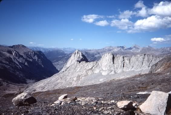
Here is the view of The Whaleback from Glacier Lake, just below Triple Divide Pass, that I like so much. (Sorry about the bad slide scan.)
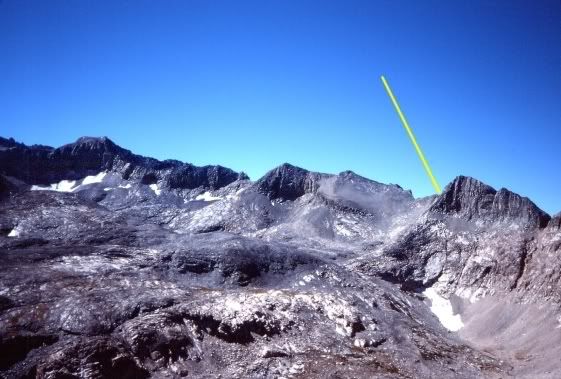
And a view of Pants Pass from Triple Divide Pass, with the yellow line pointing to Pants Pass:
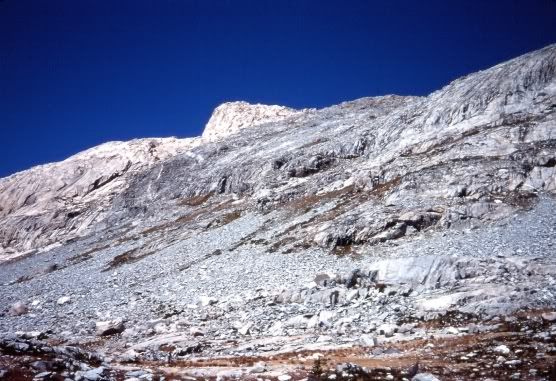
And finally, a view of the steep ridge you have to pass through to get down to the upper Kern-Kaweah watershed from Triple Divide Pass. After several trial and errors over various seasons, including working my way down a steep creekbed one year, I think the ridge shown here is the best alternative. It just takes time and patience.
Mike
Re: Triple Divide pass "dismount"
Posted: Fri Jul 10, 2009 8:56 pm
by giantbrookie
The lower part of Triple Divide Pass is certainly the trickiest part. Here's yet another way. In 2002 we did Triple Divide Pass from E to W (part of Tableland-Glacier Ridge-Josephine L-Colby L-Colby Pass-Triple Divide-Lion Lake Pass-loop out of Wolverton), leaving the Colby Pass trail at an altitude of a bit above 10800 over the Kern Kaweah River. From there the trick was to surmount the the rounded high point 12000+ 1.1 mi S of Colby Pass. There is a bit of shifting from shelf to shelf, but the way we did it there was only one very short and easy (but loose) class 3 move when we crossed into a chute above a drop off. Everything else was solid class 2. I am convinced that this approach will go 100 percent class 2 with a bit of care. Of course going W to E may be trickier as one will be descending and trying to avoid blind drop offs. Returning route from the E to W, once atop point 12000+ then one stays fairly high and north of the cliffs as one first heads WNW then curves to WSW into the gentle, high hanging valley beneath the final treadmill scree pitch up to the pass itself (this part is all class 1 and 2). I too like Glacier Lake and I also like the lake 11040+ that sits below and west of point 12000+. Another trick that isn't in Secor (and we didn't do it) appears to be that one can avoid the recommended (by Secor) descent below Glacier Lake to approach Lion Lake Pass (if headed E to W). The loose talus below Glacier Lake is pretty annoying and tedious. It seems to be better to cross the outlet from Glacier L. (at the lake) then head WSW over the little shoulder west of Glacier Lake then make a short descent in a class 2 chute directly to the little lake at the head of Cloud Canyon.
Re: Part 2: Aug. 2008 TR: Kaweah Basin, Colby Pass, etc.
Posted: Sat Jul 11, 2009 1:51 pm
by cgundersen
Hi Y'all,
First, nice shots Mike; my wife's first two photos were taken with a cheap borrowed digital camera and she's since upgraded a bit, but not to the level that a lot of folks achieve (the Whaleback is gorgeous)! Still, it's good enough for us to to refresh the mental images. Anyway, although I agree that the Whaleback looks pretty cool from up there, the perspective that's always knocked my socks off is from where you were last year, down in Big Wet meadow. Second, your Pants arrow points to a different ridge than what I've done. Last month, my wife & I did the lower ridge at the far right of your photo (and, I'd have to try to find ancient photos, but I'm pretty sure that's how I went over Pants back around the same time you did a few decades ago). Anyway, I think that both routes have their advantages/disadvantages. Our way was an easy climb out of 9 Lakes, but pretty wild descending into Kern-Kaweah. The yellow arrow route reverses the degree of difficulty.
Regarding GBs comments, yes, I've thought about heading toward Colby after doing Triple Divide, so I'm glad to hear that it's a "go". Secondly, I can confirm that hillock between Glacier Lake and Lion Pass is definitely the preferred route.
CG
Re: Part 2: Aug. 2008 TR: Kaweah Basin, Colby Pass, etc.
Posted: Sat Jul 11, 2009 11:39 pm
by Mike M.
CG:
It sounds like you and your wife went up and down what Secor calls "Piss In Your Pants Pass" -- see page 110 - 111 of the newest edition of his book, which has two photos of the area. He says there is a "vertical cliff" on the Kaweah Basin side of Piss In Your Pants Pass, which makes me think you and your wife are studs indeed for doing the pass given the conditions you found!
The route the arrow points to actually provides an easy decent into Nine Lakes Basin. Getting up from the Kaweah Basin side is harder, but there is no vertical cliff.
Mike
Re: Part 2: Aug. 2008 TR: Kaweah Basin, Colby Pass, etc.
Posted: Sun Jul 12, 2009 7:20 am
by hikerduane
Great photos and report, enjoying it all. Thank you.
Re: Part 2: Aug. 2008 TR: Kaweah Basin, Colby Pass, etc.
Posted: Sun Jul 12, 2009 3:13 pm
by cgundersen
Mike,
Hmmm; I'll obviously have to look into this Pants business a little more. Must say though, from the 9 lake basin side, the way you went looks worse. Must be one of those where the closer you get, the better it looks. Still, regardless of the answer, my wife has no interest in re-visiting Pants or its close cousins. She wants to give Pyraqueen a whirl, and from all reports that's the way to go.
CG
Re: Part 2: Aug. 2008 TR: Kaweah Basin, Colby Pass, etc.
Posted: Tue Jul 14, 2009 5:14 pm
by quentinc
Mike,
What is Milestone Pass like? I just have the Tom Harrison map, so there's not much detail, but it looks like you'd be crossing a glacier on the East side.
Re: Part 2: Aug. 2008 TR: Kaweah Basin, Colby Pass, etc.
Posted: Tue Jul 14, 2009 10:08 pm
by Mike M.
Milestone Pass is easy from the east side. The pass is actually a ridge crossing. There is a lot of talus on the west side. It is one of my favorite cross country passes -- I've been over it at least 10 times. There are great views of the Whitney range from the east side of the pass. Terrific campsites can be found high up in the drainage between Milestone and Midway.
Mike
Re: Part 2: Aug. 2008 TR: Kaweah Basin, Colby Pass, etc.
Posted: Wed Jul 15, 2009 8:50 am
by maverick
To add to what Mike said, Milestone Bowl itself is a pretty neat place too, and there is
no glacier crossing involved.