R03/R04 TR: Loop from McGee Creek 7/12-7/18 2021
-
ScubaNBeyond

- Topix Newbie
- Posts: 2
- Joined: Tue Jan 05, 2021 9:37 pm
- Experience: Level 3 Backpacker
Re: TR: Loop from McGee Creek
What an amazing trip report. You made this cross country travel sounds so easy. I wish I have your route finding skill, without a map too. Incredible! Thank you for letting me follow your trip report using my Gaia Topo.
-
robertseeburger

- Topix Expert
- Posts: 443
- Joined: Wed Apr 20, 2011 6:53 pm
- Experience: Level 4 Explorer
- Location: San Mateo Ca
Re: TR: Loop from McGee Creek
What a great TR.
This is a route that I have written down and often regretted not doing. It just hasn't made it to the top of the list.
Your TR perhaps is helping to get it there.
My own planning for a similar trip starts at Laurel Lake for the loop, but it looks similar. And in my planning, I would have gone over Franklin Pass ( I think that is name..connecting Upper Franklin with Dorothy) which I have done before. But your description of Bunny Lake Pass looks a little bit better I think.
I enjoyed your commentary on hiking without a map. I would probably accurately be described as a "map-a-holic"..( frequently looking at it).
But one time solo cross country in the Blue Canyon/Tunemah area I lost my topo map. And it was actually fun to do cross country backpacking from memory only, in a remote area.
I have to do this route someday.
-
SSSdave
- Topix Addict
- Posts: 3606
- Joined: Thu Nov 17, 2005 11:18 pm
- Experience: N/A
- Location: Silicon Valley
- Contact:
Re: TR: Loop from McGee Creek

This thread has me thinking of one of those very familiar places tonight. Plateau of Ponds. If next winter is anywhere near normal to big, I'm highly likely to do the McGee Cr - Pass - base camp at Red Slate Meadows trip I almost did this year before having to concede the state of conditions doesn't support the effort. Just compare what it looked like in 2016 late July, a bit below normal winter, to how much drier, browner, less snowy, less watery it already is as we move into August 2021.
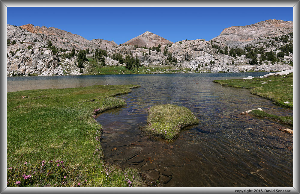
https://www.davidsenesac.com/2016_Trip_ ... 16-12.html
-
wildhiker

- Topix Fanatic
- Posts: 1220
- Joined: Tue Jul 26, 2011 4:44 pm
- Experience: Level 4 Explorer
- Location: Palo Alto, CA
- Contact:
Re: TR: Loop from McGee Creek
Thanks for another great trip report with excellent photos. That landscape is so colorful! I've been on the west side of McGee Pass, but never the east side, which looks even more colorful.
-Phil
-Phil
-
Love the Sierra

- Topix Expert
- Posts: 511
- Joined: Sat Jun 11, 2016 6:32 pm
- Experience: Level 3 Backpacker
Re: TR: Loop from McGee Creek
WOW!! Wonderful and very helpful! I think that I will be going here instead of Peter Pande. It looks beyond belief gorgeous!
Do you know if the footbridge at Tuly Hole has been fixed?
Thank you for a marvelous TR.
Aura
Do you know if the footbridge at Tuly Hole has been fixed?
Thank you for a marvelous TR.
Aura
Who is online
Users browsing this forum: No registered users and 7 guests