You pick some tough routes. My destinations always won out over dificult routes.
Here's an easy one. That's saint Diane in the pic.
R04/R01 TR: Another romp through Goddard Canyon & beyond (8/8-8/15)
-
Cross Country
- Topix Fanatic
- Posts: 1328
- Joined: Thu Dec 24, 2009 11:16 am
- Experience: Level 4 Explorer
-
Wandering Daisy

- Topix Docent
- Posts: 7070
- Joined: Sun Jan 24, 2010 8:19 pm
- Experience: N/A
- Location: Fair Oaks CA (Sacramento area)
- Contact:
Re: TR: Another romp through Goddard Canyon & beyond (8/8-8/15)
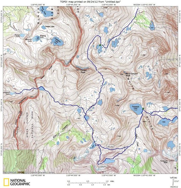
I did a similar route in 2006. I cannot remember if I wrote a trip report or not. I went in Florence Lk,over Reinstein Pass - traverse to Ionian Basin, then to the lakes below Finger Peak, over Blue Canyon Pass, then missed the pass to Tunemah - day hiked lakes below Tunemah, - back to Blue Canyon this time finding the right pass, over the pass to Hummingbird Lake - north through Pearl Lk, etc, to Confusion Lake- back out via Goddard Canyon.
I was not overly impressed with Blue Canyon - the lakes below Finger Peak were spectacular - as was Tunemah. Blue Canyon was just on my way to get to the places I wanted to see. I found Blue Canyon Pass easy - had mixed rock and snow, but snow was soft enough to kick steps. I did not have an ice axe - just trekking poles. The wrong pass I took to Tunamah was really scenic, but hard- class 3. Had to lower my pack on my bear hanging cord. The right pass (Dykman, I think) was more obvious to find from the east. I just was not paying much attention to the map and simply headed for the lowest notch when I went in - the lowest notch is NOT Dykman Pass!
Here is a map of the Blue Canyon part of the trip
-
tomba

- Topix Expert
- Posts: 508
- Joined: Sat Jun 18, 2011 12:50 pm
- Experience: Level 4 Explorer
- Location: Bay Area
Re: TR: Another romp through Goddard Canyon & beyond (8/8-8/15)
You posted it last winter. In fact I got the rough idea of my trip 2 weeks ago from your post.Wandering Daisy wrote:I did a similar route in 2006. I cannot remember if I wrote a trip report or not.
Which guidebook is this?cgundersen wrote:the same guidebook map showed a more or less direct traverse from Blue Canyon Pass to Finger col. From the tarn below Finger col, you could certainly make out where folks had started the traverse, but it's not clear that it saves any time. From our experience, the routes on the guidebook map were more for goats than geezers.
Also, Wandering Daisy, which guidebook are you referring to in your post?
Wandering Daisy wrote:I was on a bench above the south shore Confusion Lake. Although the guide book recommends staying in the slot, I found the slabs on the east side easier.
-
Turtleggjp

- Topix Acquainted
- Posts: 50
- Joined: Wed Jul 14, 2010 11:32 am
- Experience: Level 4 Explorer
Re: TR: Another romp through Goddard Canyon & beyond (8/8-8/15)
That was a very fun read! I just had my first encounter with Finger Col this year in early July. That ~15ft cliff scared me too! I camped below it and when I went to bed I began to consider all the different scenarios of how I was going to get out of there, especially if the weather was bad the next day (it wasn't). Next thing I knew, I was back at home discussing the trip with my family, and I thought to myself, "hey, that must not have been so bad after all!" Then I woke up, and Finger Col was still staring at me from above.  It turned out to be trivial on the East side, as I found the nice set of ledges that led me to the pass. That "finger" on the other side was very cool, as was the tree growing near the top of it! The other side ended up being more difficult, but just a lot of boulders, nothing technical.
It was fun to hear that I wasn't the only one spooked by Finger Col's East side!
Matt
- My camp below Finger Col
It was fun to hear that I wasn't the only one spooked by Finger Col's East side!
Matt
-
cgundersen
- Topix Fanatic
- Posts: 1346
- Joined: Sun Jul 16, 2006 1:07 pm
- Experience: N/A
Re: TR: Another romp through Goddard Canyon & beyond (8/8-8/15)
tomba
Thomas Winnett & Ed Roberts are the authors of Blackcap Mountain, which is "High Sierra Hiking Guide #3", published by Wilderness Press, Berkeley (2nd ed., 1976). Direct from the source. I just checked to see if Amazon has it, but no luck. Have not tried other online possibilities.
matt,
Cool shot of the camp, though it does not look very flat there; probably just an optical illusion. Your dream scenario sounds perfect and I'll try adopting that strategy for future gnarly climbs.
cg
-
Wandering Daisy
- Topix Docent
- Posts: 7070
- Joined: Sun Jan 24, 2010 8:19 pm
- Experience: N/A
- Location: Fair Oaks CA (Sacramento area)
- Contact:
Re: TR: Another romp through Goddard Canyon & beyond (8/8-8/15)
tomba- the guide I was referring to was Secor's guide.
Once someone puts a route in a guidebook, then nobody really explores the area to see if the guidebook route is really the best route. Another example, from Confusion Lake instead of dropping down like the guidebook route says, I traversed north, gradually descending, following the natural benches and got down to Goddard Creek without much more than class 1. It was steep, but mostly grass. Very little talus.
Once someone puts a route in a guidebook, then nobody really explores the area to see if the guidebook route is really the best route. Another example, from Confusion Lake instead of dropping down like the guidebook route says, I traversed north, gradually descending, following the natural benches and got down to Goddard Creek without much more than class 1. It was steep, but mostly grass. Very little talus.
-
Turtleggjp
- Topix Acquainted
- Posts: 50
- Joined: Wed Jul 14, 2010 11:32 am
- Experience: Level 4 Explorer
Re: TR: Another romp through Goddard Canyon & beyond (8/8-8/15)
I don't think it was perfectly flat there, but it wasn't terribly not flat either. I actually slept very good all four nights of that trip, but that could be because I did so much each day that I was very tired each night. Another interesting thing about that trip I remember, I went the entire time (5 days) without ever turning on my headlamp.cgundersen wrote:Cool shot of the camp, though it does not look very flat there; probably just an optical illusion. Your dream scenario sounds perfect and I'll try adopting that strategy for future gnarly climbs.
Matt
-
Jimr

- Forums Moderator

- Posts: 2182
- Joined: Fri Jul 31, 2009 2:14 pm
- Experience: Level 4 Explorer
- Location: Torrance
Re: TR: Another romp through Goddard Canyon & beyond (8/8-8/15)
Here's a pic of the west side lakes from Finger Col
If you don't know where you're going, then any path will get you there.
Who is online
Users browsing this forum: No registered users and 1 guest