If you've been searching for the best source of information and stimulating discussion related to Spring/Summer/Fall backpacking, hiking and camping in the Sierra Nevada...look no further!
In those photos it appears the guard rail on the right side on the bridge is damaged. However, the bridge is standing since you can see the shadow on the water below.
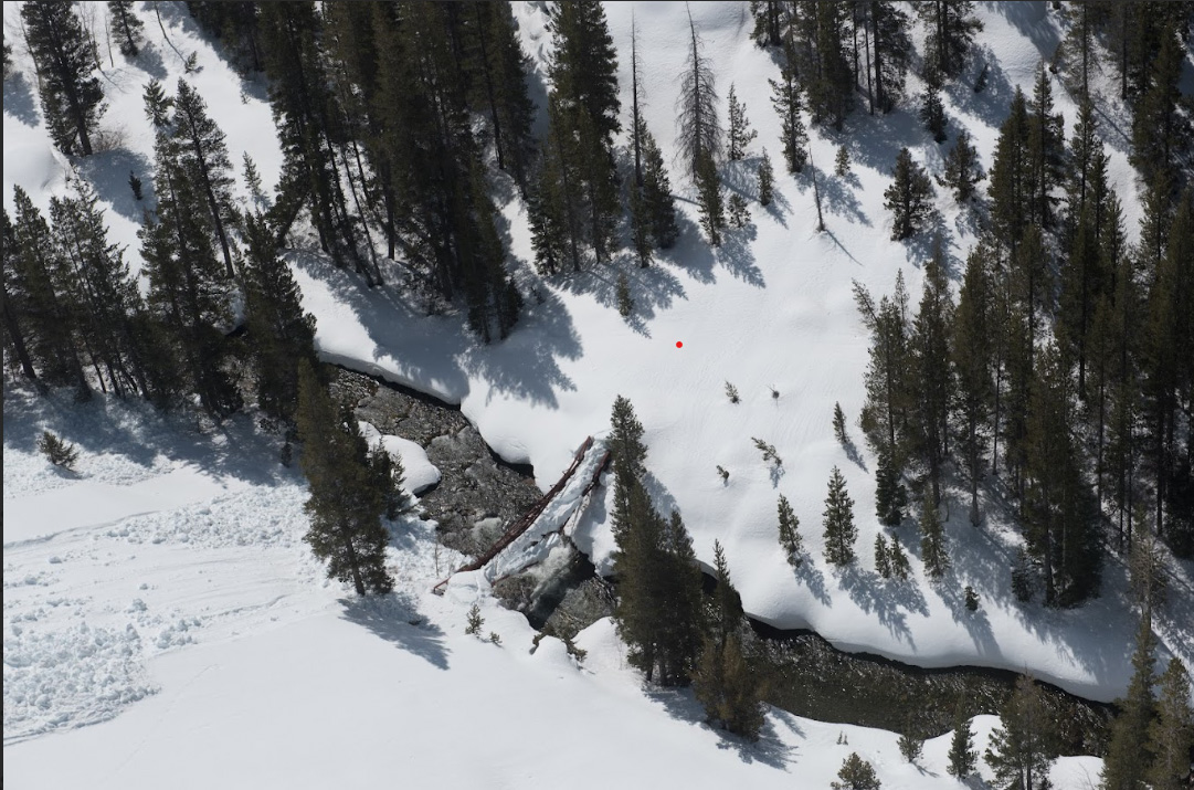
hard to say for sure, but I’d say the failure is a “twisting” mode as well as being bowed sideways. The twisting effect looks like it’s lowered the downstream edge into the water. When spring melt really picks up, the bridge might not stay in place much longer.
I have done Lamarck Col to North Lake and hiked from the JMT/PCT at the river up and out over Puite Pass to North Lake. I have done two Cottonwood pass to Happy Isles JMT trips and one Happy Isles to Whitney Portal JMT trip over the last 15 years.
I would think the vast majority of the typical casual JMT hikers wouldn't consider the detour using Lamarck Col as a viable option.
Between the very heavy lingering snow, high river water and the bridge problem, this may be a record for the fewest people completing the JMT for the season in decades.
I have a Cottonwood Pass to Bishop Pass trip planned this September and was planning to hike from South Lake to Happy Isles next year. Bringing my 72 year old brother on both trips for his first Sierra backing trips.
The PCT/JMT trail impact from this bridge is huge. It wouldn't surprise me for the park service to make it a priority for replacement. At best it the work could be completed before the snow hits next fall. Don't know if the damage is limited to the steel span or if the bridge approaches on each side would need to be replaced also.
The resupply to the McClure Meadow ranger station would also be a challenge. I assume pack animals don't normally cross Muir pass. Maybe it would just stay closed until the bridge is replaced.
jimmyjamhikes wrote: ↑Fri Apr 21, 2023 7:04 am
kpeter, you'd have to cross back over Evolution Creek to stay on the eastern shore of South Fork San Joaquin
What does Evolution Creek look like in the flats at the bottom before it joins the South Fork? When I hiked this I did both bridges in a short period of time and only saw Evolution Creek after climbing up the switchbacks on the way up and finally came back to the falls and cascades. The trail did not go close to the creek down in the valley, so I never saw the possible fording points.
Here's the Google Maps satellite view of the confluence of Evolution Creek with the South Fork San Joaquin River, probably taken in mid summer (some snow still on the peaks when you zoom out). There doesn't seem to be any "flat" where the streams join. It looks like Evolution Creek is cascading all the way down to the confluence.
I have a NOBO permit starting Aug 16, 23. Looking at a detour option comprised of Goddard Canyon Trail, over Hell for Sure pass to Reddys Hole Trail or Burnt Corral Trail and continuing past Florence Lake to MTR. Can anyone speak to what Reddys Hole Trail (and/or this plan as a whole) is like? It is on some maps and not on some others. I am assuming it is more of a "route" that an established trail. Any info on the trails on this side of the bridge detour greatly appreciated. I am trying to gather some info on viable re-route options so that I can "cross that bridge when I come to it." Sorry, that was terrible.
@ajbettencourt... (Mmmm. your username is not "notification linking"?)
Here is a photo from 2018 of the Burnt Corral trail junction sign on the main Maxson - Long Meadow trail at Long Meadow. I recall saying to my daughter: "Ah, my kind of trail!" as it was almost completely overgrown and semi-hidden, though still quite visible there. I also did that trail from Florence Lake back in the 1990's and it was not too bad I believe as I was not even aware of X-country stuff then. So, I think it could be an option for you.
Burnt Corral Jct.
However, another option could be going north earlier after Hell For Sure to Mosquito Pass and then down to the South Fork San Joaquin from there. I did that too back then and had my brother with me on his first backpacking trip so do not recall the drop down from Mosquito Pass being a bushwhack or anything. The contours look a bit steep on that slope in places but again I do not recall any real difficulty and believe I found granite zones to go down on amongst the trees. Certainly the exit point back onto the PCT is in a very convenient location east of Muir Trail Ranch! It was really beautiful in that meadow too...BUT...you then have to cross the South Fork of the San Joaquin! So maybe that is of no help whatsoever as when we did it the river was no obstacle even though we had hit snow en route. Perhaps further down nearer Blayney Meadows it opens up into multiple channels and flat water but I have no idea for this year by the time you are in the territory presumably September or fall.
grampy wrote: ↑Fri Apr 21, 2023 12:34 pm
hard to say for sure, but I’d say the failure is a “twisting” mode as well as being bowed sideways. The twisting effect looks like it’s lowered the downstream edge into the water. When spring melt really picks up, the bridge might not stay in place much longer.
The bridge IS definitely entirely above water at the time these images were taken. A close examination of the enlarged image indicates daylight between the bridge and its shadow, downstream. Given this is early season, the bridge decking probably hasn't been contacted by the river. The damage appears to be caused from heavy snow loads on the decking. Any twist damages probably indicates the downstream side of the bridge was weaker than the upstream portion of the structure. Some of that perceived twist and down stream bow, however, may be accounted for as an illusion caused by the perspective from where the image was taken.
Regarding Reddys Hole and Red Rock Basin : I went through there last year, and so no signs of a trail on the route I took. But it is easy terrain, so whether you find a trail or not it is pretty easy going. I also went through there on skis in 2011. I think if you have any off trail experience then a HFS Pass/Lower indian Lake/Reddys Hole/Red Rock Basin route to get to Thompson pass and the trail heading down to almost Florence could be a good move. That gets you close to the bridge that crosses the SJ close to where the river reaches the lake. Once you are over HFS Pass, I think that route is better than taking the trail down to Post Corral and going up Burnt Corral, especially since it avoids any question of the Post Corral crossing. No significant streams going through RH or RRB, as the best route stays up high in the drainages.