Page 2 of 3
Posted: Tue Jul 03, 2007 9:47 pm
by Rosabella
Greg... These are some of the most beautiful sierra pictures I ever seen! You've always had a way to capture the most spectacular scenes and somehow create an almost a magical feel to them, especially the ones with moving water.... but these were amazing!
So, you've piqued my interest, and I think I'm going to get my maps out to find this "Kaweah Basin". I've done very little x-country, but I'm comfortable with a map and compass, so I'd be fine with it.
It sounds like a wonderful trip!
Posted: Wed Jul 04, 2007 12:18 pm
by maverick
Hello Quentin,
It's approx 30 miles to the point across from Kern point where you ascent. The Black Rock Pass route with Spring Lake, Little Five, Big Arroyo, and Nine Lakes Basin is pretty.
Pants Pass is only very steep at the last 30 ft on both sides, with a steep dirt section on the eastern side (don't slip or lose your balance on this section). From there on, it is skiing on screen.
The Colby route starts boring through the Sugarloaf area (hot and dry from mid-season on), but it gets much better once you get to Roaring River.
The views of the Whaleback are impressive, and Colby Lake is quite beautiful. You could head up the western side of the Whaleback and go over Lion Lake Pass and Lion Rock Pass to the Nine Lakes Basin.
Triple Divide Pass from Glacier Lake is another option with incredible scenery. You can descend down to the Colby Trail, head over to Picket Creek Pass, descend to Picket Lakes, or go over the small pass into Kaweah Basin.
You could also go up Deadman Canyon and go up to Coppermine Pass and hook up with either LLP/LRP or TDP and then exit using the Colby Trail /Cloud Canyon route, giving you almost new scenery in and out (Ranger Meadow is beautiful with a great view to the south towards Elizabeth Pass).
All of these options are class 2; if you have the time, it is well worth it. I think the route from Sunset would be rated higher than the Glacier/BlackRock approach.
Posted: Wed Jul 04, 2007 2:09 pm
by copeg
Thank you doug, quentic, and Rosie! quentinc, maverick's detailed post says more than I could ever say about the approaches.
Posted: Wed Jul 04, 2007 4:52 pm
by madeintahoe
Oh My!!! Those are absolutely amazing...I LOVE them all. I looked at my map to see where you were at...it looks nice and remote. What a gorgeous part of the Sierra.
How does one choose where to go..this area is a for sure place!

Cloud Canyon is gorgeous! So nice to see it so green and lush!
Thank you for posting them!
Posted: Wed Jul 04, 2007 7:10 pm
by quentinc
Thanks Maverick. That gives me a lot to think about. Finally, how bad is Pyra-Queen pass? I ask that with the possibility of heading in from Crescent Meadow.
Posted: Thu Jul 05, 2007 12:25 pm
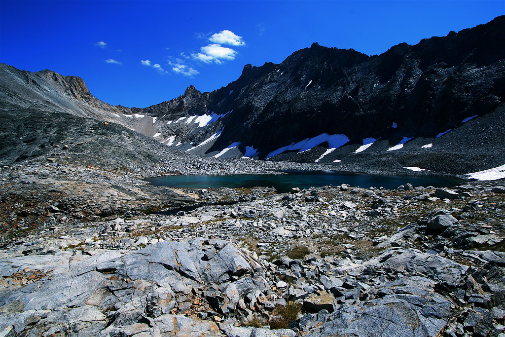
by maverick
PQC is the easiest pass from the west into Kaweah Basin, the pass is the small chute you see in the middle of the saddle from left to right above the patch of snow.
The other side is long and rocky but great scenery especially at sunrise.
Posted: Thu Jul 05, 2007 6:53 pm
by Trailtrekker06
ahhhhh. What a great trip , Trailblazer. Beautiful shots.
Posted: Fri Jul 06, 2007 6:57 am
by copeg
Thanks madeintahoe and trailtrekker! I'm still in a different world right now after being in "the real world" for a work week.
Posted: Fri Jul 06, 2007 8:13 am
by Buck Forester
YAAAA!!! Awesome adventure and pics! This stuff is what makes High Sierra Topix such a fantastic place!
Posted: Fri Jul 06, 2007 10:01 am
by lostcoyote
trailblazer
congratulations on this most outstanding photograph in your collection (my opinion here of course)
http://www.naturefocused.com/archives/v ... x/IMG_7840
it is beautiful and you were at the right place at the right time