I awoke at dawn with an early start in mind, but decided to sleep some more due to rain. When there was a break in the rain and clouds, I headed through the campground to the trailhead and started uptrail. Within fifteen minutes of hiking uphill, rain, hail, thunder, and lightning let loose, so I left the trail and took shelter among a grove of small trees surrounded by larger trees, scaring a herd of deer out of their spot. After an hour of squatting under my jacket, and checking weather radar, the thundestorm subsided and I continued to Robinson Lake.
 Viewed 516 times")
- Robinson Lake
I had reached the end of obvious trail and was over two hours behind my intended start, so I didn't linger long and quickly worked my way up the rocky terrain above the lake, generally following the stream.
 Viewed 516 times")
- Looking east to Robinson Lake, Onion Valley, and Owens Valley
 Viewed 516 times")
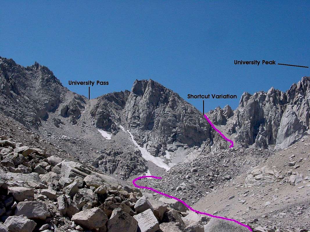
- Route above Robinson Lake heading to University Pass
As the shortcut is described as steeper, my objective was the normal University Pass Route (image by Bob Burd):
I reached the base of the scree chute and started up. As I climbed, clouds swept over the crest again and it began to sprinkle. I appreciated the cooling effect as I slogged up the steep scree. In the sections of firmer rock that I ventured through, I took care not to knock much material down, but did manage to dislodge one rock with my foot, sending it crashing downslope. As I crested the top of the pass, clouds were blowing just above me. Hail and then light snow began to fall, melting on me and leaving me to hope views would open up at some point and that conditions would not worsen. I was relieved that I did not hear thunder. I shifted from warm to cold and focused on putting on as much warm and waterproof gear as I had packed. Within five minutes, there were signs of clearing as I looked south along the ridge to Mt. Bradley...
 Viewed 516 times")
- South ridgeline from University Pass
 Viewed 516 times")
- West from University Pass
I wolfed down a snack and some water as I hurriedly began moving to warm up and to progress along the SE ridge traverse to University Peak.
http://www.summitpost.org/university-peak/151291
 Viewed 516 times")
- Center Peak
 Viewed 516 times")
- Looking northwest at fresh hail far below from near the junction of the SE Ridge and University Shoulder routes just below the summit of University Peak
Warmed by the summit push, I dropped some layers and snapped some images.
 Viewed 516 times")
- Looking north to Kearsarge Pass and Mt. Gould
 Viewed 516 times")
- Looking down to the east side of Kearsarge Pass
At this point I could have completed a class 2 loop by descending the University Shoulder route to Kearsarge Lakes and gotten to Kearsarge Pass faster, but I opted for a longer route to see more areas. I angled back toward the University Pass Route to Center Basin. The closest lake in that basin was calling my name.
 Viewed 516 times")
- Center Peak and Basin from near University Pass
Heading back on the normal route would have kept what became stiff class 2 in places to easy class 2, but I enjoyed the plunge stepping portions and reached the lake quickly. The water quenched my thirst and presented a golden opportunity to dry my clothes and rinse off some sweat.
 Viewed 516 times")
- Swimming with a view of Center Peak
I worked my way northeast and downslope, eventually reaching the JMT along Bubbs Creek after spying the largest buck I had ever seen. I found the walk very scenic as far as trails go, but soon had to adjust to seeing other folks hiking or camping along the trail every 10-15 minutes after having solitude all morning and most of the afternoon.
 Viewed 516 times")
- Bubbs Creek
Soon, I was amazed to reach a junction that could bring me to Roads End in Kings Canyon nearly as quickly as my hike back to Onion Valley would be, but that option made no sense on this hike. I enjoyed the ferns, forest and views on the way up to Bullfrog Lake. Just prior to reaching the lake, some friendly backpackers called to me from their camp and insisted on feeding me some of their overabundance of snacks to help lighten their load slightly. I was pleasantly surprised to learn that they planned to head over Forester Pass and do Tyndall, and even more pleased that their energy snacks gave me a needed boost before my last upward push.
I was alone all the way over Kearsarge Pass where dusk turned to moonless night. I took advantage of the mostly smooth trail, walking with trekking poles under starlight with a brisk wind at my back. A mile before reaching the trailhead, a bright light began to shine toward me and in my eyes. I donned my headlamp so as not to frighten the fellow hikers. Not long after, it was good to get back to my family at the campground for a meal and long rest.


