If you've been searching for the best source of information and stimulating discussion related to Spring/Summer/Fall backpacking, hiking and camping in the Sierra Nevada...look no further!
Thanks for taking the time to write up this TR, and give us a peak at the conditions
in that area. Cute dogs!
Don't get why we have over 100 views and no one has chimed in yet , we
all here at HST need to show folks we appreciate there effort and time posting TR's
otherwise some members will not do so in the future.
Professional Sierra Landscape Photographer
I don't give out specific route information, my belief is that it takes away from the whole adventure spirit of a trip, if you need every inch planned out, you'll have to get that from someone else.
Have a safer backcountry experience by using the HST ReConn Form 2.0, named after Larry Conn, a HST member:http://reconn.org
Thanks for posting the information and pictures from this lovely hike. I plan to google information as to where this is. If it is close to me, I want to backpack to the lake.
Spent a lot of time of there when i was 18-22. Hunted, fished. An excellent stomping ground to learn things. Gooseberries, wild strawberries, other edibles.
Thanks for the early season report. It's amazing how early things are thawing out this year. I recall a super dry year (1988, I believe) when I was up there and it may have had even less snow, but this year is certainly an early thaw. If Loon is thawed, this means some favorite hike to fishing spots accessible from there are, too.
giantbrookie wrote:Thanks for the early season report. It's amazing how early things are thawing out this year. I recall a super dry year (1988, I believe) when I was up there and it may have had even less snow, but this year is certainly an early thaw. If Loon is thawed, this means some favorite hike to fishing spots accessible from there are, too.
Professor Brookie,
Check out my newest post in the fishing hole. Those lakes are indeed thawed and the fishing is great!
6 RBL.JPG
7 Trout.JPG
Thanks,
-Russ
You do not have the required permissions to view the files attached to this post.
"...Or have you only comfort, and the lust for comfort, that stealthy thing that enters the house a guest, and then becomes a host and then a master?"
Thank-you Tom. That is not very far away from me, at all. I would like to add it to my list for this summers hiking. It looks very doable to hike from Loon Lake to Craig Lake. Possibly a 6 or 7 day trip.
That lake is an awesome gateway to Desolation Wilderness. Unlike many of the east side trailheads, and associated zone quotas, you can always get space out of there. The trailhead parking area is huge and mostly shaded too. Good stuff, thanks for sharing!
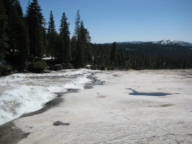
Last year I did a quick overnight above Bassi Falls during the spring melt and really enjoyed it. The large polished granite area above the falls is really cool.
I was concerned with all of the private property postings on your way up to the falls. I didn't see any more after the scramble to the top of the falls and beyond though. I actually checked with the FS Ranger beforehand and they really couldn't give me a definitive answer. They only said to follow the FS maps and any posted signs.
I'm still rather convinced that you can achieve more than you've ever dreamed of if you just lower your standards.
paula53 wrote:Thank-you Tom. That is not very far away from me, at all. I would like to add it to my list for this summers hiking. It looks very doable to hike from Loon Lake to Craig Lake. Possibly a 6 or 7 day trip.
You are most welcome! I presume that you mean Crag Lake? I usually misspell it too. I looked for a different Craig Lake and didn't find one. The reason I ask is because of some map inaccuracies. The PCT runs through the valley where the headwater of General Creek arise. To the east is a parallel valley with a string of lakes on Meeks Creek. Old USGS maps show an east-west trail connecting the General Creek Trail, near its terminus at the PCT, with the Meeks Creek Trail. This east-west trail is shown as terminating at Lake Genevieve (which is adjacent to Crag Lake). That east-west connector trail no longer exists. There are no markers for it. I have crossed Meeks creek just below Genevieve and looked around many times over the years and can find no remnants of a trail. Also, the trail is not shown on any newer maps. You might be able to XC through that section, but my guess is you'd be doing a lot of bushwhacking. Orienteering through forest is trickier than above the treeline and you'd likely be crawling over a lot of downed trees and fighting your way through a lot of brush. Your possibilities in going east from Loon Lake would be to depart the PCT down the General Creek Trail, or to turn off the PCT onto the Meeks Creek Trail near Phipps Peak. The string of lakes along Meeks Creek are beautiful. Best of luck in planning your trip!