I am planning a similar trip. We plan to leave from Maxon Trailhead and proceed up the Hell-for-Sure Pass trail to Devil's Punchbowl. From there we want to go to the Schoolmarm Lake, Six Shooter Lake, Wah Hoo Lake, Holster Lake area and spend the night. The next morning we plan to go down Bench Valley to Colt Lake and Guest Lake to the Bench Valley Trail. We will return to Maxon Trailhead via Big Maxon Meadow and Post Corral Meadow. I am really interested in hearing from anyone that has gone from Devil's Punchbowl to the Bench Valley via the pass just southwest of Mt Hutton. I understand from other posts that this area is often referred to as Devil's Saddle of Lucifer's Pass or in the book "The High Sierra - Peaks, Passes and Trails" it is called "Two Passes".
Let me know if you have experience in this area of the John Muir Wilderness.
Devil's Punchbowl to Schoolmarm Lake via Devil's Saddle
-
perkins75

- Topix Novice
- Posts: 7
- Joined: Wed Feb 20, 2013 10:22 am
- Experience: N/A
- Location: San Ramon, CA
-
SweetSierra

- Topix Regular
- Posts: 303
- Joined: Mon May 16, 2011 12:23 pm
- Experience: Level 4 Explorer
- Location: Tucson, Arizona
Re: Devil's Punchbowl to Schoolmarm Lake via Devil's Saddle
It was named "Lucifer's Saddle" by the late Sierra Mountaineer Jim Watters. I've been over it once on the route you're planning. From the highest lake below the saddle, scramble up Class 2 rock to the first saddle. It's not difficult, just some climbing that requires a few hand and foot holds. When you reach that first obvious saddle, you'll see a steep slope with big talus blocks in front of you. Don't climb that. Look to your right and there's a fairly wide shelf. Take that a short distance, then veer left and up a very easy slope to the second saddle and ridgetop where you look down into Bench Valley. It's an easy walk to the lakes in Bench Valley.
-
perkins75
- Topix Novice
- Posts: 7
- Joined: Wed Feb 20, 2013 10:22 am
- Experience: N/A
- Location: San Ramon, CA
Re: Devil's Punchbowl to Schoolmarm Lake via Devil's Saddle
Are there any helpful landmarks from the Devil's Punchbowl/Big Shot lake area to help get me to the first saddle you refer to?
-
AlmostThere
- Topix Addict
- Posts: 2724
- Joined: Wed Jun 24, 2009 4:38 pm
- Experience: Level 4 Explorer
Re: Devil's Punchbowl to Schoolmarm Lake via Devil's Saddle
I can post pictures when i get home. I was there last year.
Sent from my HTC Glacier using Tapatalk 2
Sent from my HTC Glacier using Tapatalk 2
-
perkins75
- Topix Novice
- Posts: 7
- Joined: Wed Feb 20, 2013 10:22 am
- Experience: N/A
- Location: San Ramon, CA
Re: Devil's Punchbowl to Schoolmarm Lake via Devil's Saddle
Some pictures would be wonderful!! Thanks.
-
SweetSierra
- Topix Regular
- Posts: 303
- Joined: Mon May 16, 2011 12:23 pm
- Experience: Level 4 Explorer
- Location: Tucson, Arizona
Re: Devil's Punchbowl to Schoolmarm Lake via Devil's Saddle
I'm glad AlmostThere has photos. We didn't start at Devil's Punchbowl but came over from Disappointment Lake to above Devil's Punchbowl. It was easy to contour from Disappointment Lake. Then we climbed a fairly steep but doable slab to the next level that holds Big Shot/Little Shot lakes. We contoured around the lakes until we reached the last lake's inlet stream. The route up may have been near the inlet stream but I don't remember with certainty. The climb up is over medium-sized talus--I said handholds, etc., but it's really just a short climb over not-too-steep talus. I remember that it didn't take that long to climb up to the first saddle.
-
maverick

- Forums Moderator

- Posts: 11870
- Joined: Thu Apr 06, 2006 5:54 pm
- Experience: Level 4 Explorer
Re: Devil's Punchbowl to Schoolmarm Lake via Devil's Saddle
The Sadde: http://www.picasaweb.google.com/lh/phot ... QDa0GPv38Q" onclick="window.open(this.href);return false;
http://www.flickr.com/photos/stokejob/6 ... otostream/" onclick="window.open(this.href);return false;
http://www.flickr.com/photos/stokejob/6 ... otostream/" onclick="window.open(this.href);return false;
Professional Sierra Landscape Photographer
I don't give out specific route information, my belief is that it takes away from the whole adventure spirit of a trip, if you need every inch planned out, you'll have to get that from someone else.
Have a safer backcountry experience by using the HST ReConn Form 2.0, named after Larry Conn, a HST member: http://reconn.org
-
perkins75
- Topix Novice
- Posts: 7
- Joined: Wed Feb 20, 2013 10:22 am
- Experience: N/A
- Location: San Ramon, CA
Re: Devil's Punchbowl to Schoolmarm Lake via Devil's Saddle
Maverick - Can you tell me what I am seeing in the first picture? Which direction am I looking? What is in the background?
Thanks
Thanks
-
maverick
- Forums Moderator
- Posts: 11870
- Joined: Thu Apr 06, 2006 5:54 pm
- Experience: Level 4 Explorer
Re: Devil's Punchbowl to Schoolmarm Lake via Devil's Saddle
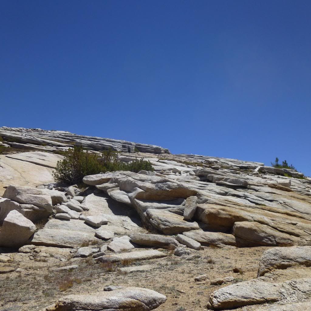
View is looking back northwest from the start of the ascent to the first pass after leaving
Little and Big Shot Lakes area.
http://www.highsierratopix.com/high-sie ... m=14&cat=2" onclick="window.open(this.href);return false;,
Use Google Earth to track the whole described route two both passes. Also try zooming
down to the ground level to get an idea of the topography from a different angle to.
Professional Sierra Landscape Photographer
I don't give out specific route information, my belief is that it takes away from the whole adventure spirit of a trip, if you need every inch planned out, you'll have to get that from someone else.
Have a safer backcountry experience by using the HST ReConn Form 2.0, named after Larry Conn, a HST member: http://reconn.org
I don't give out specific route information, my belief is that it takes away from the whole adventure spirit of a trip, if you need every inch planned out, you'll have to get that from someone else.
Have a safer backcountry experience by using the HST ReConn Form 2.0, named after Larry Conn, a HST member: http://reconn.org
-
AlmostThere
- Topix Addict
- Posts: 2724
- Joined: Wed Jun 24, 2009 4:38 pm
- Experience: Level 4 Explorer
Re: Devil's Punchbowl to Schoolmarm Lake via Devil's Saddle
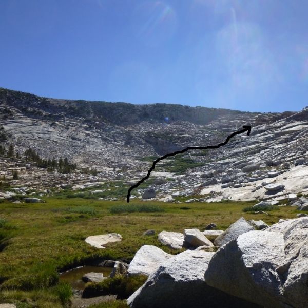
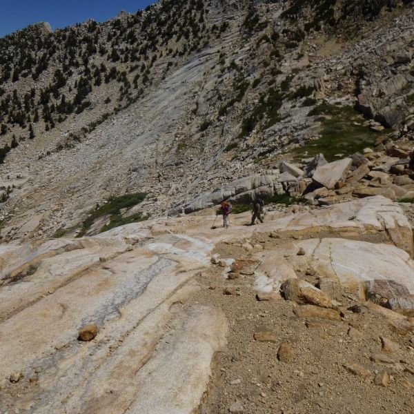
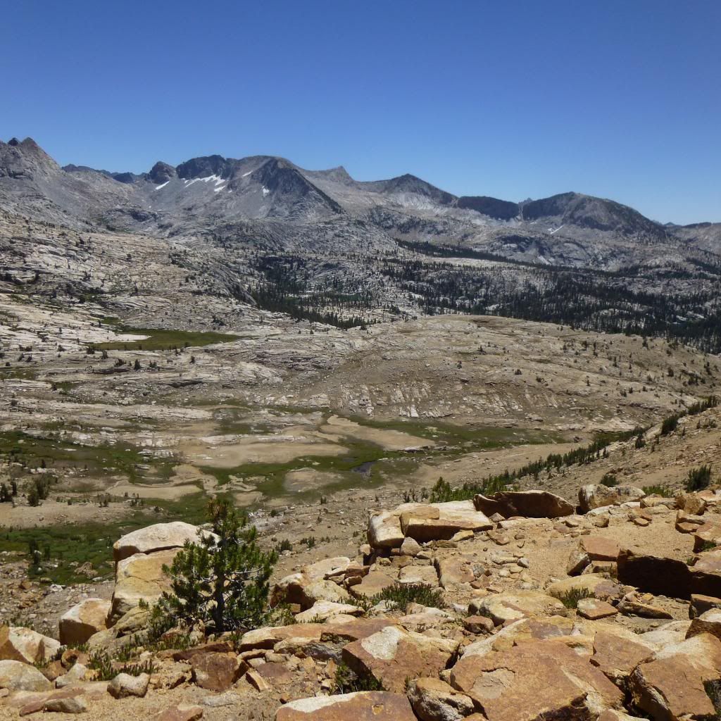
going up from Punchbowl to the little and big shot lakes, then up from there to a meadow with an unnamed tarn, you see the above. I traced a line to mark the approximate route we took, which doesn't mean you should follow it.
this is looking back down at where the top of the arrow pointed, roughly.
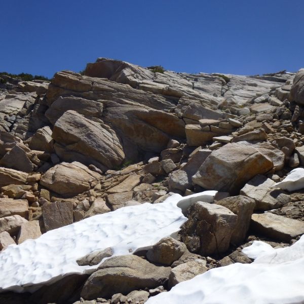
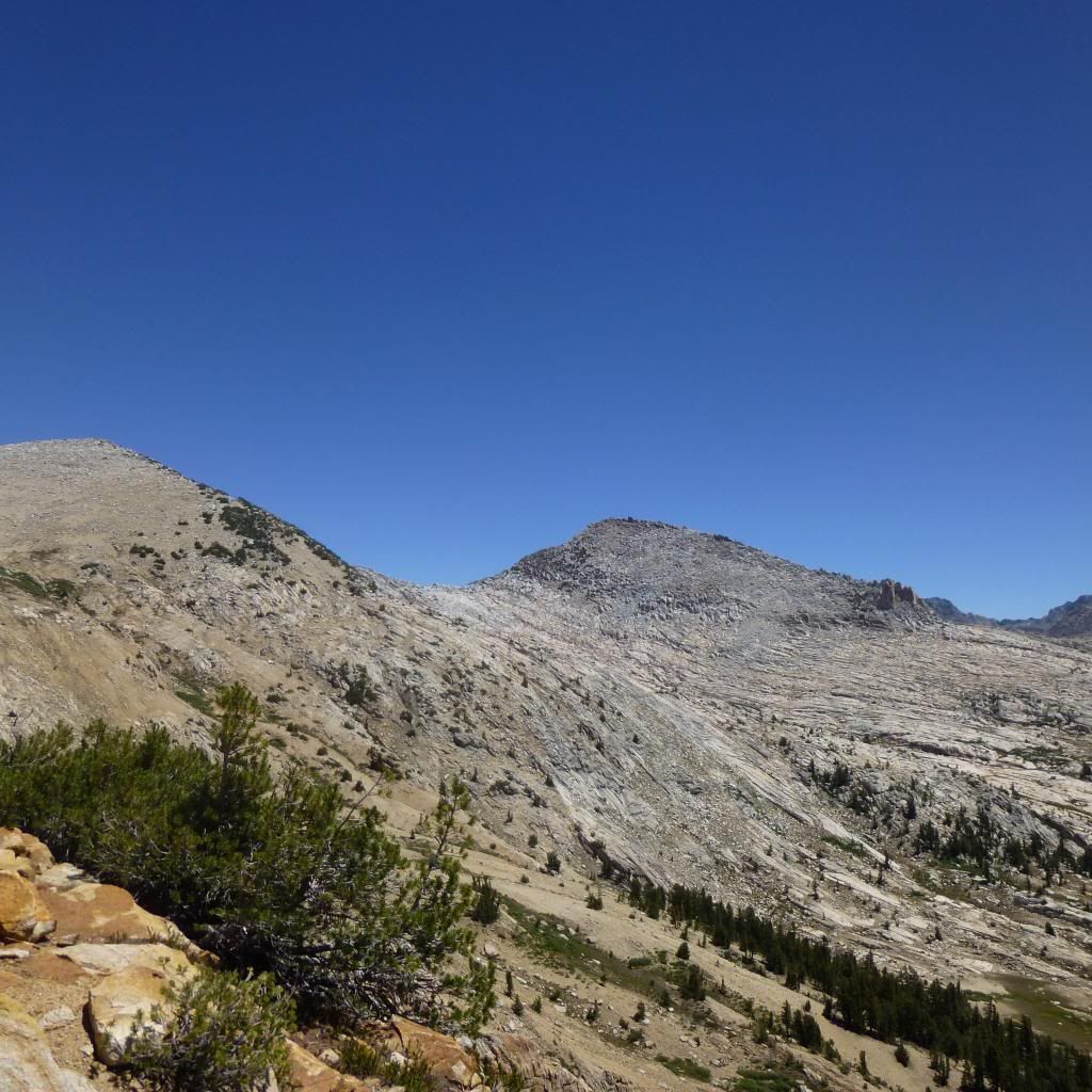
Looking up from where the previous picture was taken, at the final bit of climbing to get to the first saddle. This was steep but class 1.
when you get up that last bit you get this view. You look left and get:
Go uphill and traverse left. There start to be occasional cairns up here. Just go forward.
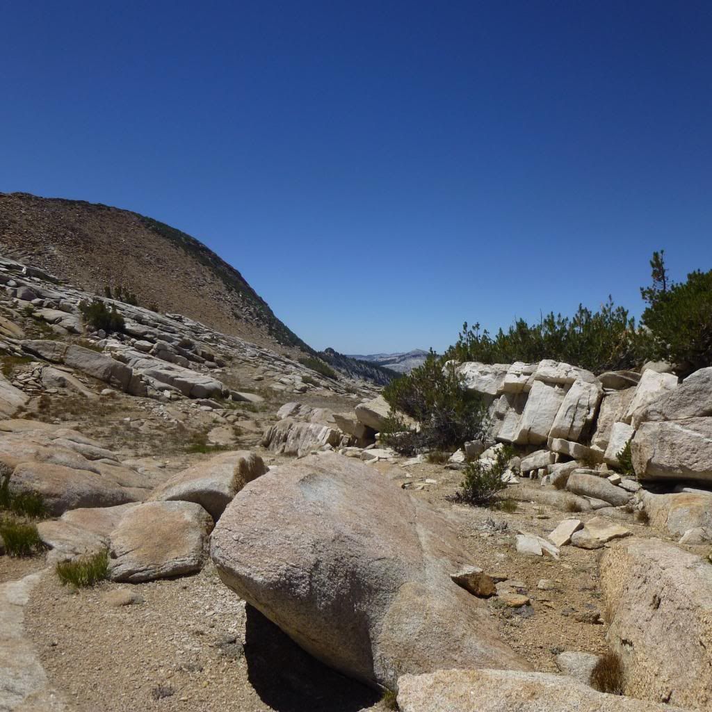
In the second saddle you see a change in the rocks and this view. looking down you think you can't just walk down it, but there's a route going down and north.
This is of the view north, the route we took goes down and then we zigzagged down into bench valley which is shown in the previous shot.
There was a big cairn in the second saddle.
Take a topo map.
Who is online
Users browsing this forum: Bing [Bot], Google Adsense [Bot] and 16 guests