Hi folks,
I am going on a backpacking trip with son and friend in midSeptember from Thousand Island Lake to Yosemite Valley. I have read Roper's book for advice on the cross country/off trail part. I am most concerned about bit from North Glacier Pass (between Thousand Island Lake and Catherine Lake) to Twin Island Lakes. Does anyone have any suggestions and particularly would anyone have waypoints (latitudeslongitudes) for those few miles.
Bob
Advice on High Route: North Glacier Pass to Twin Lakes
-
Bob

- Topix Novice
- Posts: 6
- Joined: Tue Aug 14, 2007 9:49 am
- Experience: N/A
-
cgundersen
- Topix Fanatic
- Posts: 1346
- Joined: Sun Jul 16, 2006 1:07 pm
- Experience: N/A
Hi Bob,
I (and undoubtedly others) can supply more details, but I was through there in early July with my wife and we climbed up to Catherine from the west side (but, I've gone east to west, too). Anyway, there is steady boulder-hopping around Catherine, and then the best (in my mind) route is more or less to follow the outflow creek till you reach the point that you'd need climbing gear (it's obvious). The best route then, for the direction you're going, is to do a broad traverse to your right (northwest) and then cut back to the plateau that's about halfway down the hillside. On our trip, my wife and I climbed up the southern side (because we wanted to visit the Ritter Lakes) and it was appreciably slower going but still "doable". Once you reach the plateau, there is a nice "use trail" just to the north (to your right) of the creek that will take you down to the basin from which you can access the Twin Island Lakes. I'm planning to post photos soon, so that may make it clearer.
cgundersen
PS: And, where are you headed from Twin Island Lakes....on trail, or off?
-
Bob
- Topix Novice
- Posts: 6
- Joined: Tue Aug 14, 2007 9:49 am
- Experience: N/A
Thank you very much for your very informative reply. After Twin Lakes we will continue west to Blue Lake and after that I believe head NW until we get on trail. From then on it will be trails to Half Dome, which we want to go up, and then probably Happy Isles unless we have gone very fast and have an extra day. Any suggestions or ideas are welcome.
I am very interested in seeing your photos when you post them.
Bob
I am very interested in seeing your photos when you post them.
Bob
-
cgundersen
- Topix Fanatic
- Posts: 1346
- Joined: Sun Jul 16, 2006 1:07 pm
- Experience: N/A
Hi Bob,
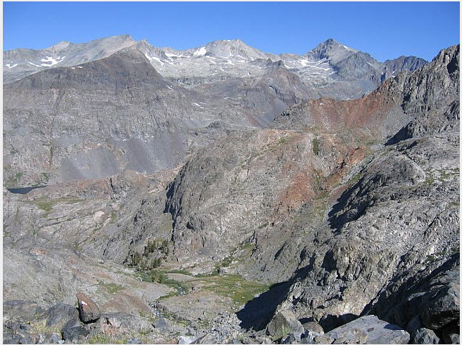
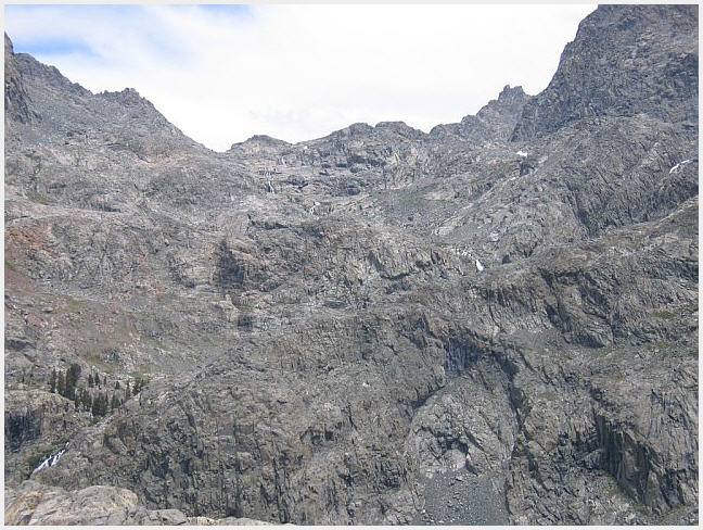
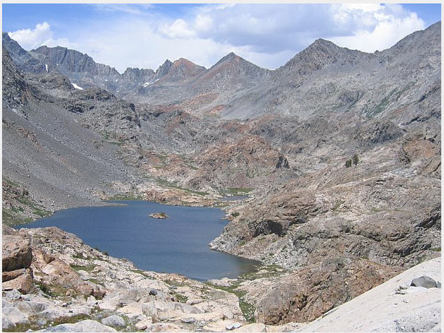
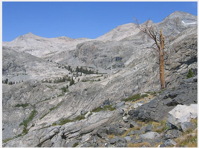
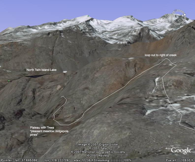
I'll insert some of the key shots below. Your planned route should be incredible; as I noted in another posting earlier this summer, Blue Lakes are probably my favorite location of anywhere I've been in the Sierras. They are a bit of a challenge to reach (particularly, from the direction you guys are going), but eminently worth the effort. The first photo I post is the key shot for getting down from Catherine. It shows the loop out to the right of the creek that you need to make before reaching the plateau (with trees) from which you make the final descent on the use trail. It may look daunting on this scale, but it's not so bad up close. In addition, I'll insert shots of the incredible scenery that you'll get to stare at whilst catching your breath; as well as the traverse from Twin Island up toward Blue Lakes (it too looks a bit daunting, but we just followed the easiest contours and although one stretch is pretty steep, it's not at all harrowing.
The descent from Catherine:
This is what the hillside (that leads up to Catherine from the west) looks like from below:
This is lower Twin Island Lake looking further up the canyon. The route up to Catherine is more to the right:
This shot is taken at about the midpoint of the traverse from Twin Island Lakes to Blue Lakes (which sit up the drainage where the trees fade out):
cgundersen
-
Bob
- Topix Novice
- Posts: 6
- Joined: Tue Aug 14, 2007 9:49 am
- Experience: N/A
Cathrine Lake photo & GoogleEarth
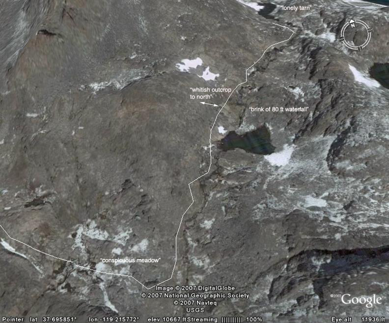
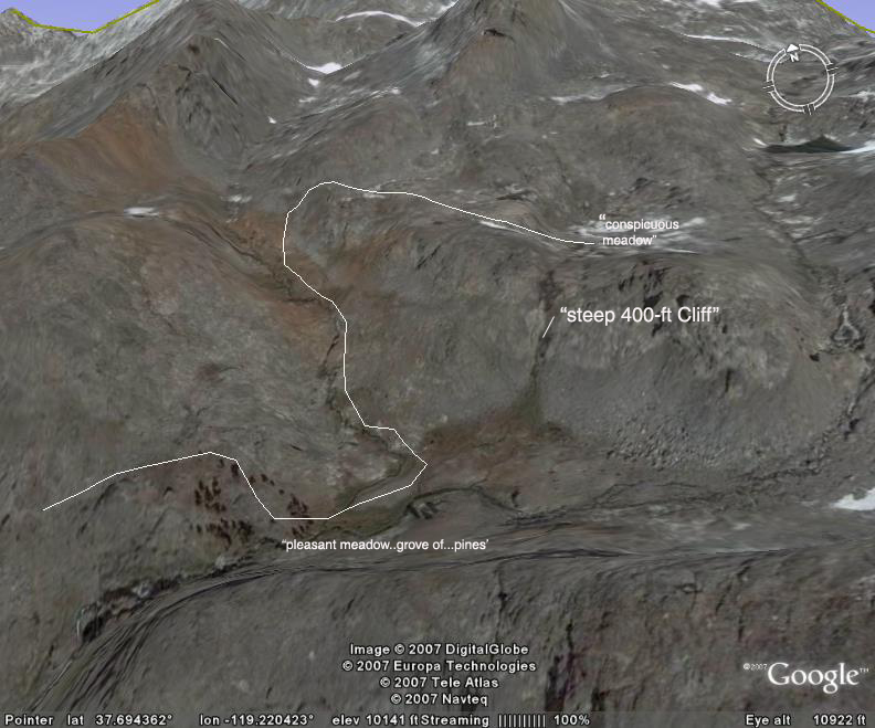
I looked at your photo of getting down from Catherine Lake, then my wife suggested I try GoogleEarth. With your photos and descriptions, along with Roper's descriptions, using GoogleEarth made the trip seem much clearer.
No doubt others on this list serve have used it, but for me it was mindbloggling how useful this tool is. At any rate, attached are a few images I took off of GoogleEarth and added some labels to.
The quotes on the photos are from Steve Roper's book "Sierra High Route". The first photo I tried to rotate and change the perspective to match your photo as much as possible. Then I drew in the path I think you were referring to, including phrases from your email.
Thanks again,
Bob
[I am not sure I have figured out how to link to photos. If not, just copy the URL and paste into browser address to see them]
Match to photo:
Leg of trip from tarn below Catherine Lake by 80 ft waterfall to Roper's "conspicuous meadow" above 400 ft cliff
Leg of trip from above 400 ft cliff, down red gully, to meadow with pine trees
[/img]
EDIT: To post photos, you have to make sure the "Disable BBCode in this post" box at the bottom is not checkmarked.
ERIC
-
Bob
- Topix Novice
- Posts: 6
- Joined: Tue Aug 14, 2007 9:49 am
- Experience: N/A
Test of photo insertion:
<img src="http://www.nbrhd.net/Backpacking/2007Se ... oMatch.jpg">
<p>
<img src="http://www.nbrhd.net/Backpacking/2007Se ... Circle.jpg">
<p>
<img src="http://www.nbrhd.net/Backpacking/2007Se ... Meadow.jpg">
<img src="http://www.nbrhd.net/Backpacking/2007Se ... oMatch.jpg">
<p>
<img src="http://www.nbrhd.net/Backpacking/2007Se ... Circle.jpg">
<p>
<img src="http://www.nbrhd.net/Backpacking/2007Se ... Meadow.jpg">
-
cgundersen
- Topix Fanatic
- Posts: 1346
- Joined: Sun Jul 16, 2006 1:07 pm
- Experience: N/A
Hi Bob,
Wow, the Google images are pretty amazing! Incidentally, once you reach Blue Lake, the obvious route out of there is the ridge south of Foerster which reaches a small lake on the plateau north of Harriet Lake(on a post by Maverick earlier this year, he came over the ridgeline further south, and it's considerably more challenging). Anyway, depending on how much "spare" time you guys have, the basin of the Lyell fork of the Merced is spectacular, and even if you don't go far up the basin, the unnamed lake immediately below Ansel Adams peak is beautiful and has a fabulous camping area on its western shore (plus, it's all down hill, once you reach the ridge above Blue).
cgundersen
-
cgundersen
- Topix Fanatic
- Posts: 1346
- Joined: Sun Jul 16, 2006 1:07 pm
- Experience: N/A
-
quentinc
- Topix Expert
- Posts: 890
- Joined: Tue Nov 01, 2005 10:28 pm
- Experience: N/A
- Location: Los Angeles
Well, I just got back from it myself. It was smokey the first two days and then crystal clear. It was gorgeous all around -- perfect in every way... except for a dislocated shoulder.  But I didn't let that stop me from completing the backpack and even tying on an extra day to do part of the High Route on the east side of the Ritter Range. I'll post a trip report when I finish getting my pictures together.
Who is online
Users browsing this forum: tmcdev and 5 guests