To quote maverick from 2 last seasons:
maverick wrote:
This is not a place to post trip reports, but a place for members to post a quick update on conditions experienced in the back-country on recent trips. Posting photo's of difficult sections encountered is encouraged.
This will allow other members considering visiting, or traveling, through the same location a heads up on difficult sections, so they can plan/prepare or re-route accordingly.
This is meant to be a quick reference for members, with up to date information, saving time from having to look through numerous trip reports to gather pertinent information for an upcoming trip. Just paste the form below into you post, and fill out the info.
Please do not ask questions about a particular area or post anything but a report
in this thread. Thanks
In the "Subject" above (title of post) section please post the area you visited, include
the dates.
Route taken:
Difficult section encountered:
Special equipment needed/used:
Possible alternative routes:
SAMPLE:
Subject: Rae Lakes-Lake Reflection-Sphinx Lakes 7/12/12 to 7/18/12
Route: Roads End-Upper Paradise Valley-Rae Lakes-Glen Pass-Junction Meadow-Lake
Reflection-Longley Pass-Cinder Col-Sphinx Col-Sphinx Lakes-Roads End
Difficult section encountered on this trip:
- Lost of snow on northern side of Glen Pass icy in the morning hours.
- Bubbs Creek crossing very difficult, found the best crossing point 400 yards west
of the usual low water crossing section.
- Big cornice encountered on Longley Pass, which was bypass by climbing rocky
section north of the pass (class 3).
Special equipment needed/used:
- Ice Axe
- Crampons
- Trekking Poles
Possible alternative routes:
- When crossing Bubb's, I notice a section about 100 yards further west that looked
much easier.
- Should have bypassed the cornice on the southern side, route looked barely class 2.
New members, please consider giving us an intro!
Follow us on Twitter @HighSierraTopix. Use hashtags #SIERRAPHILE #GotSierra? #GotMountains?
Follow us on Facebook: https://www.facebook.com/HighSierraTopix
2016 Backcountry Conditions Reports
-
rlown

- Topix Docent
- Posts: 8224
- Joined: Thu Oct 25, 2007 5:00 pm
- Experience: Level 4 Explorer
- Location: Wilton, CA
-
tomba

- Topix Expert
- Posts: 508
- Joined: Sat Jun 18, 2011 12:50 pm
- Experience: Level 4 Explorer
- Location: Bay Area
Donner Pass ski conditions Sunday 4/17
Last Sunday I skied for a few hours in Castle Valley starting from Donner Summit SNO Park. There was 100% snow coverage.
-
AlmostThere

- Topix Addict
- Posts: 2724
- Joined: Wed Jun 24, 2009 4:38 pm
- Experience: Level 4 Explorer
Re: 2016 Backcountry Conditions Reports
Not precisely backcountry conditions, but perhaps relevant to those interested in Kings Canyon trailheads.
The Deer Creek (Monarch Wilderness trailhead) is closed, no hiking there at the moment. The Yucca Flats trail is also closed/roped off. Recommend checking on road status if you intend to leave the highway to get to a trailhead, as signs indicate most are closed to the public. The Converse grove may not be accessible this year.
The Lewis Creek trail appears open but I think it will not be pleasant hiking - the Copper Creek trail on the other hand looks like you would be starting out at least in normal forested conditions. Rae Lakes loop trailheads are as usual and the trail up as far as Paradise is in really good shape with just a couple of trees down.
At the moment, there is still complete coverage in areas 9000+ feet - melting is rapid in elevations below 9000, and patchy snow in the sequoias along 180. The early season Rae Lakes backpackers we saw either had snowshoes or shorts -- I think we know who will make it all the way around.
-
maverick

- Forums Moderator

- Posts: 12150
- Joined: Thu Apr 06, 2006 5:54 pm
- Experience: Level 4 Explorer
Re: 2016 Backcountry Conditions Reports
AT,
Would you have any pictures you could please post of the area, personally my interest is the Deer Cove area, but seeing other sections that were affected by the Rough Fire in that area would be informative to many here. Thanks
Would you have any pictures you could please post of the area, personally my interest is the Deer Cove area, but seeing other sections that were affected by the Rough Fire in that area would be informative to many here. Thanks
Professional Sierra Landscape Photographer
I don't give out specific route information, my belief is that it takes away from the whole adventure spirit of a trip, if you need every inch planned out, you'll have to get that from someone else.
Have a safer backcountry experience by using the HST ReConn Form 2.0, named after Larry Conn, a HST member: http://reconn.org
-
AlmostThere
- Topix Addict
- Posts: 2724
- Joined: Wed Jun 24, 2009 4:38 pm
- Experience: Level 4 Explorer
Re: 2016 Backcountry Conditions Reports
Pictures really don't capture it. When you're in the canyon you can't see the slope above in entirety, and angles from the road are difficult. The slope above Cedar Grove proper and west was burnt out -- you can see the damage everywhere. The whole Monarch Wilderness is torched. The entire north facing slope where the road winds downward to Kings Canyon is burnt, and wildflowers are rampant. The Lodge is totally gone but they saved the home on the slope above it.maverick wrote:AT,
Would you have any pictures you could please post of the area, personally my interest is the Deer Cove area, but seeing other sections that were affected by the Rough Fire in that area would be informative to many here. Thanks
I can see from the Rough Fire damage map that the entirety of the Lewis Creek trail was burnt out, but Granite Pass/Copper is untouched. Hotel Creek/Lewis Creek trails are going to be ashy and unpleasant for a while...
-
maverick
- Forums Moderator
- Posts: 12150
- Joined: Thu Apr 06, 2006 5:54 pm
- Experience: Level 4 Explorer
Re: 2016 Backcountry Conditions Reports
Thankfully that is incorrect, the fire line did not jump the Harrington Ridge. Swamp, Slide, Kennedy and the Volcanic Lakes areas were not affected, the Swamp and Slide Lakes areas are the highlights of Monarch Wilderness.The whole Monarch Wilderness is torched.
http://inciweb.nwcg.gov/photos/CASNF/20 ... 7-CDT.jpeg
Professional Sierra Landscape Photographer
I don't give out specific route information, my belief is that it takes away from the whole adventure spirit of a trip, if you need every inch planned out, you'll have to get that from someone else.
Have a safer backcountry experience by using the HST ReConn Form 2.0, named after Larry Conn, a HST member: http://reconn.org
I don't give out specific route information, my belief is that it takes away from the whole adventure spirit of a trip, if you need every inch planned out, you'll have to get that from someone else.
Have a safer backcountry experience by using the HST ReConn Form 2.0, named after Larry Conn, a HST member: http://reconn.org
-
BufordT
- Topix Novice
- Posts: 15
- Joined: Fri Aug 21, 2015 2:28 pm
- Experience: N/A
- Contact:
Mt Silliman 04/29/16
Hope this gives an idea of current snowpack in Sequoia. Elevation from 6800' to 11,200'.
Route taken: Twin Lakes trail from Lodgepole, cross country up Silliman Creek
Difficult section encountered: About 50% snow (drift) coverage by 7500'. About 8000' on up 100% coverage. Deep but consolidated. Soft even in morning.
Special equipment needed/used: Trekking poles very helpful, carried ice axe and crampons but weren't necessary.
You do not have the required permissions to view the files attached to this post.
Celebrate the Trudge at http://enkooth.com
-
markskor

- Founding Member - RIP
- Posts: 2442
- Joined: Fri Oct 28, 2005 5:41 pm
- Experience: Level 4 Explorer
- Location: Crowley Lake and Tuolumne Meadows
Re: 2016 Backcountry Conditions Reports
Just a glimpse of current conditions - Mammoth Lakes area today...5/10/16...(just a little 7-mile warm-up.)
Gate at Twin Lakes up to Lakes Basin still locked - roads are plowed/ dry. Twin Lakes (8400') completely open, but Lake Mary (8900') - below pic - turning a little blue but still 99% frozen over....2 - 6 feet of snow everywhere. BTW, snow consolidated - slick as snot mornings...passable till early afternoons...posthole hell later on. George (9300') is completely covered still - long way to go if going any higher. Just a FYI to all those contemplating hiking up high in the next few weeks...I wouldn't, unless you really know what the hell you're doing.
Gate at Twin Lakes up to Lakes Basin still locked - roads are plowed/ dry. Twin Lakes (8400') completely open, but Lake Mary (8900') - below pic - turning a little blue but still 99% frozen over....2 - 6 feet of snow everywhere. BTW, snow consolidated - slick as snot mornings...passable till early afternoons...posthole hell later on. George (9300') is completely covered still - long way to go if going any higher. Just a FYI to all those contemplating hiking up high in the next few weeks...I wouldn't, unless you really know what the hell you're doing.
You do not have the required permissions to view the files attached to this post.
Mountainman who swims with trout
-
Vaca Russ

- Topix Expert
- Posts: 809
- Joined: Mon Aug 16, 2010 3:12 pm
- Experience: Level 4 Explorer
- Location: The Nut Tree
Re: 2016 Backcountry Conditions Reports
Just posted a report for those curious about the conditions in southern Deso (viewtopic.php?f=14&t=14309).markskor wrote:Just a FYI to all those contemplating hiking up high in the next few weeks...I wouldn't, unless you really know what the hell you're doing.
-Russ
You do not have the required permissions to view the files attached to this post.
"...Or have you only comfort, and the lust for comfort, that stealthy thing that enters the house a guest, and then becomes a host and then a master?"
Kahil Gibran.
Kahil Gibran.
-
Hobbes
- Topix Fanatic
- Posts: 1120
- Joined: Wed Apr 27, 2011 8:09 am
- Experience: N/A
- Location: The OC
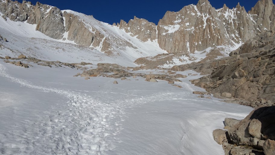
Whitney 5/14
Just got back from a Whitney hike. Clear until 9.5k, snow/clear was 80/20 around 10k @ Lone Pine lake, with 100% coverage above Outpost camp @ 10.5k.
Only post-holed twice in approx 9 miles (in/out) of snow travel walking in boots. (This was traveling between 3:30am and 9:30am.) Only wore crampons & used ice axe for the Chute, starting from Trail camp @ 12,050 and topping out at Trail Crest @ 13,600. The rest of the time was just poles with snow baskets.
I turned around at Trail crest - my first failed summit attempt. Based on advice of the only two people (from the looks of them, hardcore solos ie weather beaten with proper kits) to summit in the prior two days, got up @ 2:30am, started climbing the Chute @ 3:30am (in pitch black conditions with headlamp following established tracks), got to Trail crest at first visibility @ 5:15am. Reports from the two about the main trail to summit were sketch - one said a 1,500' fall off from the narrow boot track, the other was clinging to a boulder to pass a nasty section, his ice axe of no use. I wasn't really feeling the groove of going out 2.2 miles **and** then quickly returning via the same route to avoid having the snow just start to soften even a tad (around 9am) along the west ridge, so I decided to just plunge step all the way back down. Broke camp and walked out, getting to my car @ 11am. Got cleaned up, grabbed a burger, drove home and was having a beer in my own kitchen @ 5:30pm.
Yes, that is a 3/4 season, two person, 5lb tent. Btw, the Chute & Trail crest is directly above the center line in the tent - you can see the tracks if you look closely:

Trail was completely obscured above Outpost @ 10.5k. These tracks bypassed the entire section of trail above Mirror lake to Trail camp following the Consultation drainage (under the snow). Some took the tracks to the right going by Trailside meadow (under snow), while most (including myself) went left past Consultation (frozen completely solid), and then hooked back to TC:
Only post-holed twice in approx 9 miles (in/out) of snow travel walking in boots. (This was traveling between 3:30am and 9:30am.) Only wore crampons & used ice axe for the Chute, starting from Trail camp @ 12,050 and topping out at Trail Crest @ 13,600. The rest of the time was just poles with snow baskets.
I turned around at Trail crest - my first failed summit attempt. Based on advice of the only two people (from the looks of them, hardcore solos ie weather beaten with proper kits) to summit in the prior two days, got up @ 2:30am, started climbing the Chute @ 3:30am (in pitch black conditions with headlamp following established tracks), got to Trail crest at first visibility @ 5:15am. Reports from the two about the main trail to summit were sketch - one said a 1,500' fall off from the narrow boot track, the other was clinging to a boulder to pass a nasty section, his ice axe of no use. I wasn't really feeling the groove of going out 2.2 miles **and** then quickly returning via the same route to avoid having the snow just start to soften even a tad (around 9am) along the west ridge, so I decided to just plunge step all the way back down. Broke camp and walked out, getting to my car @ 11am. Got cleaned up, grabbed a burger, drove home and was having a beer in my own kitchen @ 5:30pm.
Yes, that is a 3/4 season, two person, 5lb tent. Btw, the Chute & Trail crest is directly above the center line in the tent - you can see the tracks if you look closely:
Trail was completely obscured above Outpost @ 10.5k. These tracks bypassed the entire section of trail above Mirror lake to Trail camp following the Consultation drainage (under the snow). Some took the tracks to the right going by Trailside meadow (under snow), while most (including myself) went left past Consultation (frozen completely solid), and then hooked back to TC:
Last edited by maverick on Sun May 29, 2016 12:37 pm, edited 1 time in total.
Reason: Subject matter
Reason: Subject matter
Who is online
Users browsing this forum: kdemtchouk and 1 guest